
New England is a region consisting of six states in the Northeastern United States: Connecticut, Maine, Massachusetts, New Hampshire, Rhode Island, and Vermont. It is bordered by the state of New York to the west and by the Canadian provinces of New Brunswick to the northeast and Quebec to the north. The Gulf of Maine and Atlantic Ocean are to the east and southeast, and Long Island Sound is to the southwest. Boston is New England's largest city and the capital of Massachusetts. Greater Boston, comprising the Boston–Worcester–Providence Combined Statistical Area, houses more than half of the region's total population. The Greater Boston area includes Worcester, Massachusetts, the second-largest city in New England; Manchester, New Hampshire, the largest city in New Hampshire; and Providence, Rhode Island, the capital of and largest city in Rhode Island.
In 1620, the Pilgrims established Plymouth Colony, the second successful settlement in British America after the Jamestown Settlement in Virginia, founded in 1607. Ten years later, Puritans established Massachusetts Bay Colony north of Plymouth Colony. Over the next 126 years, people in the region fought in four French and Indian Wars until the English colonists and their Iroquois allies defeated the French and their Algonquian allies.
In the late 18th century, political leaders from the New England colonies initiated resistance to Britain's taxes without the consent of the colonists. Residents of Rhode Island captured and burned a British Royal Navy ship which was enforcing unpopular trade restrictions, and residents of Boston threw British tea into the harbor. Britain responded with a series of punitive laws stripping Massachusetts of self-government which the colonists called the "Intolerable Acts". These confrontations led to the first battles of the American Revolutionary War in 1775 and the expulsion of the British authorities from the region in spring 1776. The region played a prominent role in the movement to abolish slavery in the United States, and it was the first region of the U.S. transformed by the Industrial Revolution, initially centered on the Blackstone and Merrimack river valleys.
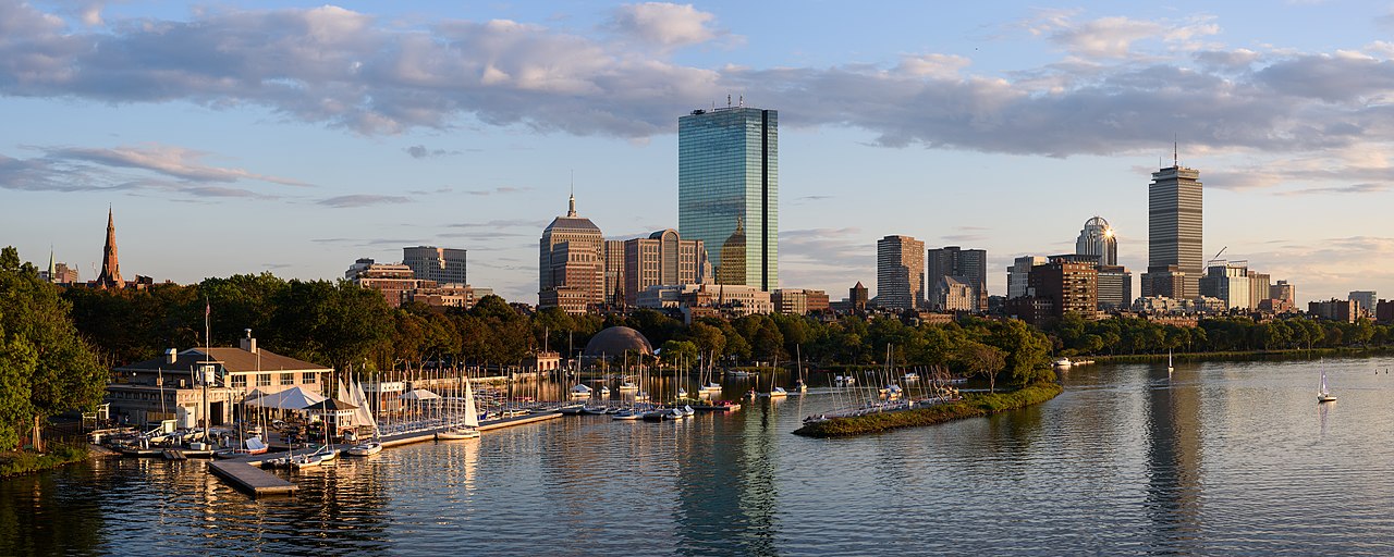
The physical geography of New England is diverse. Southeastern New England is covered by a narrow coastal plain, while the western and northern regions are dominated by the rolling hills and worn-down peaks of the northern end of the Appalachian Mountains. The Atlantic fall line lies close to the coast, which enabled numerous cities to take advantage of water power along the many rivers, such as the Connecticut River, which bisects the region from north to south.
Each state is generally subdivided into small municipalities known as towns, many of which are governed by town meetings. Unincorporated areas exist only in portions of Maine, New Hampshire, and Vermont, and village-style governments common in other areas are limited to Vermont and Connecticut. New England is one of the U.S. Census Bureau's nine regional divisions and the only multi-state region with clear and consistent boundaries. It maintains a strong sense of cultural identity, although the terms of this identity are often contrasted, combining Puritanism with liberalism, agrarian life with industry, and isolation with immigration.
History
Pre-history
Humans reached the current-day New England region by at least 10,500 years ago and likely earlier, occupying a recently de-glaciated environment. Pre-contact Native American groups in New England did not have market economies and physical artifacts tended to change very slowly. However, technological shifts brought agriculture and ceramics to the region prior to the arrival of European settlers in the 17th century.
Algonquian
The communities inhabiting the territory in the period of European colonization spoke a variety of the Eastern Algonquian languages. Prominent tribes included the Abenakis, Mi'kmaq, Penobscot, Pequots, Mohegans, Narragansetts, Nipmucs, Pocumtucks, and Wampanoags. Prior to the arrival of European colonists, the Western Abenakis inhabited what is now New Hampshire, New York, and Vermont, as well as parts of Quebec and western Maine. Their principal town was Norridgewock in today's Maine.
The Penobscots lived along the Penobscot River in Maine. The Narragansetts and smaller tribes under their sovereignty lived in Rhode Island, west of Narragansett Bay, including Block Island. The Wampanoags occupied southeastern Massachusetts, Rhode Island, and the islands of Martha's Vineyard and Nantucket. The Pocumtucks lived in Western Massachusetts, and the Mohegan and Pequot tribes lived in Connecticut. The Connecticut River Valley linked numerous tribes culturally, linguistically, and politically.
As early as 1600 CE, French, Dutch, and English traders began exploring the New World, trading metal, glass, and cloth for local beaver pelts. Many Indigenous communities are still present in modern-day New England and remain within traditional territorial boundaries, including the ten federally recognized tribes spread out across the region.

Colonial period
On April 10, 1606, King James I of England issued a charter for the Virginia Company, which consisted of the London Company and the Plymouth Company. These two privately funded ventures were intended to claim land for England, to conduct trade, and to return a profit. In 1620, the Pilgrims arrived on the Mayflower and established Plymouth Colony in Massachusetts, beginning the history of permanent European colonization in New England.
In 1616, English explorer John Smith named the region "New England". The name was officially sanctioned on November 3, 1620, when the charter of the Virginia Company of Plymouth was replaced by a royal charter for the Plymouth Council for New England, a joint-stock company established tew into the Colony of Rhode Island and Providence Plantations in 1636. At this time, Vermont was uncolonized, and the territories of New Hampshire and Maine were claimed and governed by Massachusetts. As the region grew, it received many immigrants from Europe due to its religious tolerance and economy.
French and Indian Wars
Relationships alternated between peace and armed skirmishes between colonists and local Native American tribes, the bloodiest of which was the Pequot War in 1637 which resulted in the Mystic massacre. On May 19, 1643, the colonies of Massachusetts Bay, Plymouth, New Haven, and Connecticut joined in a loose compact called the New England Confederation (officially "The United Colonies of New England"). The confederation was designed largely to coordinate mutual defense, and it gained some importance during King Philip's War which pitted the colonists and their Indian allies against a widespread Indian uprising from June 1675 through April 1678, resulting in killings and massacres on both sides. In the aftermath of settler-Native conflicts, hundreds of captive Indians were sold into slavery. Up until 1700, Native Americans comprised a majority of the non-white labor force in colonial New England.
During the next 74 years, there were six colonial wars that took place primarily between New England and New France, during which New England was allied with the Iroquois Confederacy and New France was allied with the Wabanaki Confederacy, beginning with King William's War in 1689. Mainland Nova Scotia came under the control of New England after the Siege of Port Royal (1710), but both New Brunswick and most of Maine remained contested territory between New England and New France. The British eventually defeated the French in 1763, opening the Connecticut River Valley for British settlement into western New Hampshire and Vermont.
The New England Colonies were settled primarily by farmers who became relatively self-sufficient. Later, New England's economy began to focus on crafts and trade, aided by the Puritan work ethic, in contrast to the Southern colonies which focused on agricultural production while importing finished goods from England.
Dominion of New England
By 1686, King James II had become concerned about the increasingly independent ways of the colonies, including their self-governing charters, their open flouting of the Navigation Acts, and their growing military power. He therefore established the Dominion of New England, an administrative union including all of the New England colonies. In 1688, the former Dutch colonies of New York, East New Jersey, and West New Jersey were added to the dominion. The union was imposed from the outside and contrary to the rooted democratic tradition of the colonies, and it was highly unpopular among the colonists.

The dominion significantly modified the charters of the colonies, including the appointment of royal governors to nearly all of them. There was an uneasy tension among the royal governors, their officers, and the elected governing bodies of the colonies. The governors wanted unlimited authority, and the different layers of locally elected officials would often resist them. In most cases, the local town governments continued operating as self-governing bodies, just as they had before the appointment of the governors.
After the Glorious Revolution, in 1689, Bostonians overthrew the royal governor, Sir Edmund Andros. During a popular and bloodless uprising, they seized dominion officials and adherents to the Church of England. These tensions eventually culminated in the American Revolution, boiling over with the outbreak of the War of American Independence in 1775. The first battles of which were fought in Lexington and Concord, Massachusetts, leading to the Siege of Boston by continental troops. In March 1776, British forces were compelled to retreat from Boston.
New England in the new nation
After the dissolution of the Dominion of New England, the colonies of New England ceased to function as a unified political unit but remained a defined cultural region. There were often disputes over territorial jurisdiction, leading to land exchanges such as those regarding the Equivalent Lands and New Hampshire Grants.
By 1784, all of the states in the region had taken steps towards the abolition of slavery, with Vermont and Massachusetts introducing total abolition in 1777 and 1783, respectively. The nickname "Yankeeland" was sometimes used to denote the New England area, especially among Southerners and the British.
Vermont was admitted to statehood in 1791 after settling a dispute with New York. The territory of Maine had been a part of Massachusetts, but it was granted statehood on March 15, 1820, as part of the Missouri Compromise. Today, New England is defined as the six states of Maine, Vermont, New Hampshire, Massachusetts, Rhode Island, and Connecticut.
New England's economic growth relied heavily on trade with the British Empire, and the region's merchants and politicians strongly opposed trade restrictions. As the United States and the United Kingdom fought the War of 1812, New England Federalists organized the Hartford Convention in the winter of 1814 to discuss the region's grievances concerning the war, and to propose changes to the United States Constitution to protect the region's interests and maintain its political power. Radical delegates within the convention proposed the region's secession from the United States, but they were outnumbered by moderates who opposed the idea.
Politically, the region often disagreed with the rest of the country. Massachusetts and Connecticut were among the last refuges of the Federalist Party, and New England became the strongest bastion of the new Whig Party when the Second Party System began in the 1830s. The Whigs were usually dominant throughout New England, except in the more Democratic Maine and New Hampshire.
Industrial Revolution
New England was key to the Industrial Revolution in the United States. The Blackstone Valley running through Massachusetts and Rhode Island has been called the birthplace of America's industrial revolution. In 1787, the first cotton mill in America was founded in the North Shore seaport of Beverly, Massachusetts as the Beverly Cotton Manufactory. The Manufactory was also considered the largest cotton mill of its time. Technological developments and achievements from the Manufactory led to the development of more advanced cotton mills, including Slater Mill in Pawtucket, Rhode Island. Towns such as Lawrence, Massachusetts, Lowell, Massachusetts, Woonsocket, Rhode Island, and Lewiston, Maine became centers of the textile industry following the innovations at Slater Mill and the Beverly Cotton Manufactory.
The Connecticut River Valley became a crucible for industrial innovation, particularly the Springfield Armory, pioneering such advances as interchangeable parts and the assembly line which influenced manufacturing processes all around the world. From early in the nineteenth century until the mid-twentieth, the region surrounding Springfield, Massachusetts and Hartford, Connecticut served as the United States' epicenter for advanced manufacturing, drawing skilled workers from all over the world.
The rapid growth of textile manufacturing in New England between 1815 and 1860 caused a shortage of workers. Recruiters were hired by mill agents to bring young women and children from the countryside to work in the factories. Between 1830 and 1860, thousands of farm girls moved from rural areas where there was no paid employment to work in the nearby mills, such as the Lowell Mill Girls. As the textile industry grew, immigration also grew. By the 1850s, immigrants began working in the mills, especially French Canadians and Irish.
New England as a whole was the most industrialized part of the United States. By 1850, the region accounted for well over a quarter of all manufacturing value in the country and over a third of its industrial workforce. It was also the most literate and most educated region in the country.
Political and demographic shift
During the same period, New England and areas settled by New Englanders (upstate New York, Ohio's Western Reserve, and the upper midwestern states of Michigan and Wisconsin) were the center of the strongest abolitionist and anti-slavery movements in the United States, coinciding with the Protestant Great Awakening in the region. Abolitionists who demanded immediate emancipation had their base in the region, such as William Lloyd Garrison, John Greenleaf Whittier, and Wendell Phillips. So too did anti-slavery politicians who wanted to limit the growth of slavery, such as John Quincy Adams, Charles Sumner, and John P. Hale. The anti-slavery Republican Party was formed in the 1850s, and all of New England became strongly Republican, including areas that had previously been strongholds for both the Whig and the Democratic parties. New England remained solidly Republican until Catholics began to mobilize behind the Democrats, especially in 1928. This led to the end of "Yankee Republicanism" and began New England's relatively swift transition into a consistently Democratic stronghold in national elections.
The flow of immigrants continued at a steady pace from the 1840s until cut off by World War I. The largest numbers came from Ireland and Britain before 1890, and after that from Quebec, Italy, and Southern Europe. The immigrants filled the ranks of factory workers, craftsmen, and unskilled laborers. The Irish and Italians assumed a larger and larger role in the Democratic Party in the cities and statewide, while the rural areas remained Republican.
The Great Depression and post-World War II changes
The Great Depression in the United States of the 1930s hit the region hard, with high unemployment in the industrial cities. The Boston Stock Exchange rivaled the New York Stock Exchange in 1930. The Democrats appealed to factory workers and especially Catholics, pulling them into the New Deal coalition and making the once-Republican region into one that was closely divided. However, the enormous spending on munitions, ships, electronics, and uniforms during World War II caused a burst of prosperity in every sector.
The region lost most of its factories starting with the loss of textiles in the 1930s and getting worse after 1960. The New England economy was radically transformed after World War II. The factory economy practically disappeared. Once-bustling New England communities fell into economic decay following the flight of the region's industrial base. The textile mills one by one went out of business from the 1920s to the 1970s. For example, the Crompton Company went bankrupt in 1984 after 178 years in business, costing the jobs of 2,450 workers in five states. The major reasons were cheap imports, the strong dollar, declining exports, and a failure to diversify. The shoe industry subsequently left the region as well.
What remains is very high technology manufacturing, such as jet engines, nuclear submarines, pharmaceuticals, robotics, scientific instruments, and medical devices. The Massachusetts Institute of Technology invented the format for university-industry relations in high tech fields and spawned many software and hardware firms, some of which grew rapidly. By the 21st century, the region had become famous for its leadership roles in the fields of education, medicine, medical research, high-technology, finance, and tourism.
Some industrial areas were slow in adjusting to the new service economy. In 2000, New England had two of the ten poorest cities in the U.S. (by percentage living below the poverty line): the state capitals of Providence, Rhode Island and Hartford, Connecticut. They were no longer in the bottom ten by 2010; Connecticut, Massachusetts, and New Hampshire remain among the ten wealthiest states in the United States in terms of median household income and per capita income.
Geography
The states of New England have a combined area, including water surfaces, of 71,988 square miles (186,447 km2), making the region slightly larger than the state of Washington and slightly smaller than Great Britain. Maine alone constitutes nearly one-half of the total area of New England, yet is only the 39th-largest state, slightly smaller than Indiana. The remaining states are among the smallest in the U.S., including the smallest state—Rhode Island.
The areas of the states (including water area) are:
Maine, 35,380 square miles (91,600 km2)
Massachusetts, 10,554 square miles (27,330 km2)
Vermont, 9,616 square miles (24,910 km2)
New Hampshire, 9,349 square miles (24,210 km2)
Connecticut, 5,543 square miles (14,360 km2)
Rhode Island, 1,545 square miles (4,000 km2)
Geology
New England's long rolling hills, mountains, and jagged coastline are glacial landforms resulting from the retreat of ice sheets approximately 18,000 years ago, during the last glacial period.
New England is geologically a part of the New England province, an exotic terrane region consisting of the Appalachian Mountains, the New England highlands and the seaboard lowlands. The Appalachian Mountains roughly follow the border between New England and New York. The Berkshires in Massachusetts and Connecticut, and the Green Mountains in Vermont, as well as the Taconic Mountains, form a spine of Precambrian rock.
The Appalachians extend northwards into New Hampshire as the White Mountains, and then into Maine and Canada. Mount Washington in New Hampshire is the highest peak in the Northeast, although it is not among the ten highest peaks in the eastern United States. It is the site of the second highest recorded wind speed on Earth, and has the reputation of having the world's most severe weather.
The coast of the region, extending from southwestern Connecticut to northeastern Maine, is dotted with lakes, hills, marshes and wetlands, and sandy beaches. Important valleys in the region include the Champlain Valley, the Connecticut River Valley and the Merrimack Valley. The longest river is the Connecticut River, which flows from northeastern New Hampshire for 407 mi (655 km), emptying into Long Island Sound, roughly bisecting the region. Lake Champlain, which forms part of the border between Vermont and New York, is the largest lake in the region, followed by Moosehead Lake in Maine and Lake Winnipesaukee in New Hampshire.
Climate
The climate of New England varies greatly across its 500 miles (800 km) span from northern Maine to southern Connecticut:
Maine, New Hampshire, Vermont, and western Massachusetts have a humid continental climate (Dfb in Köppen climate classification). In this region the winters are long and cold, and heavy snow is common (most locations receive 60–120 inches (150–300 cm) of snow annually in this region). The summer's months are moderately warm, though summer is rather short and rainfall is spread through the year.
In central and eastern Massachusetts, northern Rhode Island, and northern Connecticut, the same humid continental climate prevails (Dfa), though summers are warm to hot, winters are shorter, and there is less snowfall (especially in the coastal areas where it is often warmer).