
Southern Illinois is a region of the U.S. state of Illinois comprising the southern third of the state, principally south of Interstate 64. Part of downstate Illinois, it is bordered by the two most voluminous rivers in the United States: the Mississippi below its connection with the Missouri River to the west and the Ohio River to the east and south, with the tributary Wabash River, extending the southeastern border. Some areas of Southern Illinois are known historically as Little Egypt. Although part of the Midwest, certain areas of Southern Illinois more closely align culturally with neighboring parts of the Upland South (i.e. Kentucky, Tennessee, Southern Indiana, and Missouri).
South Western Illinois' most populated city is Belleville at 44,478. Other principal cities include Alton, Centralia, Collinsville, Edwardsville, Glen Carbon, Godfrey, Granite City, O'Fallon. Southern Illinois: Harrisburg, Herrin, West Frankfort, Mt. Vernon, Marion, and Carbondale, where the main campus of Southern Illinois University is located. Residents may also commute to St. Louis and Cape Girardeau, Missouri; Evansville, Indiana; and Paducah, Kentucky. The Southwestern region is home to Scott Air Force Base, a major military installation.
The area has a population of 1.2 million people, who live mostly in rural towns and cities separated by extensive farmland and the Shawnee National Forest. The two higher density areas of population are Metro East St. Louis/Southwestern Illinois (pop. 700,000+), which is the partly industrialized Illinois portion of the St. Louis Metropolitan Area, and the Southern Illinois Region of Carbondale–Marion–Herrin, Illinois Combined Statistical Area, centered on Carbondale and Marion, a two-county area that is home to 123,272 residents.

The first European settlers were French colonists in the part of their North American territory called Illinois Country. Later settlers migrated from the Upland South of the United States, traveling by the Ohio River. The region was affiliated with the southern plantation economy and rural culture. Some settlers owned slaves before the territory was organized and slavery was prohibited. Many areas developed an economy based on coal mining.
History
Early history
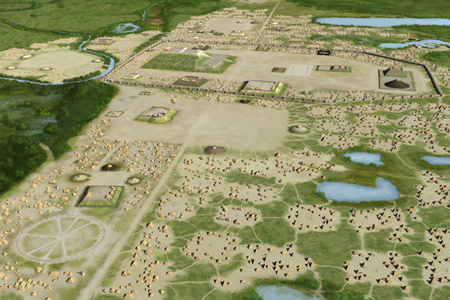
The earliest inhabitants of Illinois are thought to have arrived about 12,000 BC. They were indigenous hunter-gatherers, but they also developed their own system of agriculture. After AD 1000, the production of agricultural surpluses resulted in the development of complex, hierarchical societies. With the rise of the Mississippian culture in the Mississippi and Ohio River valleys, tribal leaders organized thousands of workers to build complex urban areas featuring numerous large earthworks – pyramidal, ridgetop and conical mounds used for religious, political and ceremonial purposes.
Cahokia, located within the boundaries of present-day Collinsville, Illinois, was the major regional center of this culture. It contains the largest prehistoric earthworks in the Americas, and has been designated as a UNESCO World Heritage Site. The mound builders' culture seems to have collapsed between 1400 and 1500 AD. The Mississippians had abandoned Cahokia long before the first European explorers arrived.

The Illinois tribes, for whom the state is named, and other historic tribes migrated to southern Illinois around AD 1500. Archaeologists say they were not descendants of the earlier inhabitants; they spoke an Algonquian language of Miami-Illini, shared in dialects among neighboring regional tribes. They had likely migrated from eastern areas, where Algonquian-speaking tribes emerged along the Atlantic Coast and waterways. The Illini left numerous artifacts, including burial sites, burned-out campfires along the bases of bluffs, pottery, flint implements, and weapons. Structures built by them include stone forts or "pounds". Visitors can see a stone fort in Giant City State Park near Makanda. At least eight other such structures are known in the region.
Illinois Country
In about 1673, French explorers from Quebec became the first Europeans to reach Illinois. The French named the area Illinois after the Indians who had greeted them. The French explored the Mississippi River, establishing outposts and seeking a route to the Pacific Ocean and the Far East. As increasing Indian unrest and warfare began in Northern Illinois over the lucrative fur trade along the Great Lakes, the French concentrated on building outposts in Southern Illinois.
The earliest European settlers were concentrated along the Mississippi, Ohio, and Wabash rivers, which provided easy routes for travel and trade. The settlements including Cahokia town, Kaskaskia and Chartres became important market villages and supply depots between Canada and the French ports on the lower Mississippi River. Other important early outposts in Southern Illinois were at Old Shawneetown and Fort Massac on the Ohio River.
After defeating the French in the French and Indian War (Seven Years' War) and signing the Treaty of Paris in 1763, the English ruled the Great Lakes region. At the time, many French settlers moved from towns on the eastern side of the Mississippi to the western side, which was ruled by Spain after the war. It took over all the Louisiana Territory west of the river. During the American Revolutionary War, the Southern Illinois area was the scene of the best known campaign in what was then the American west, when Virginians sought to occupy it against the British.
American settlers
European-American settlers were slow to arrive in Illinois after the United States victory in the American Revolutionary War. By 1800, fewer than 2,000 European Americans lived in Illinois. Soon more settlers came from the backwoods areas of Kentucky, Tennessee, Virginia, Georgia, and the Carolinas. They were mostly of English, German, and Scots-Irish descent.
In 1787, the federal government included Illinois in the Northwest Territory, an unorganized area that included present-day Ohio, Indiana, Michigan, and Wisconsin. Slavery was prohibited in this area, but for some time, slaveholders already in the area were allowed to keep their chattel property. As the areas became more populated with European Americans, they could be admitted as states to the Union. Illinois became a part of the Indiana Territory in 1800. Illinois settlers wanted more control over their own affairs and Illinois became a separate territory in 1809. It was admitted as a free state in 1818. In late 1811 and early 1812, the New Madrid earthquakes struck the region as one of the largest successions of earthquakes, including the most intensive ever inferred (not recorded) in the contiguous United States.

The first bank to be chartered in Illinois was located at Old Shawneetown in 1816. The first building used solely to house a bank in Illinois was built in 1840 in Old Shawneetown and was used until the 1920s. The Old Shawneetown State Bank has been restored as an historical site. Crops of cotton and tobacco were grown in the extreme southern region of Illinois. Cotton was grown mostly for the home weaver, but during the Civil War, cotton was also grown for export, as the regular supply of cotton from the South was not available. Enough tobacco was grown to make it a profitable crop for export. Both crops have been succeeded by other agricultural commodities.
19th century turbulence
A feud between families in Williamson County, called the Bloody Vendetta, lasted nearly ten years and took many lives. In all, 495 assaults with a deadly weapon were committed and 285 murders took place in Williamson County between 1839 and 1876.
In 1858, Abraham Lincoln ran for the U.S. Senate against incumbent Stephen A. Douglas. A series of debates were held in seven towns in Illinois, including Jonesboro and Alton. Many of the people living in Southern Illinois were first- or second-generation white Southerners. Many of these families had left the slave South to escape the economic institution of slavery despite retaining its racial ideologies.
Cairo, Illinois, at the southern tip where the Ohio River joins the Mississippi, grew to considerable commercial importance. On either bank of the rivers were states which, despite remaining loyal to the national government throughout the secession crisis, had numerous residents who, for reasons predominately rooted in racial ideologies, were sympathetic to the Southern rebellion (1860–65). Some prominent Southern Illinoisans were active in the Knights of the Golden Circle, which proposed a southern pan-Caribbean confederation of slaveholding states and nations.
The outbreak of the American Civil War exacerbated sectional tensions in the region. While the vast majority of Southern Illinoisans who served did so as U.S. volunteers, 34 men from the counties of Williamson and Jackson traveled to western Tennessee to enlist within Company G of the 15th Tennessee Volunteer Infantry. Far more served in the ranks of U.S. regiments like the 31st Illinois Volunteer Infantry, commanded by famed Southern Illinoisan John A. Logan, or 111th Illinois Volunteer Infantry, both of which were composed exclusively of Southern Illinoisans. Ulysses S Grant was commander of the District of Cairo when U.S. forces staged expeditions into the border states of Missouri and Kentucky, and the Confederate states of Tennessee and Mississippi. Despite the Southern roots of many Southern Illinoisans, 40% of eligible Southern Illinois men joined the Union Army, compared to 28% in the rest of the state.
20th century
Coal mining became an important industry in Southern Illinois around the start of the 20th century, with cities such as Harrisburg prospering, having a population of 16,000 people during the 1920s. Union miners all over the nation went on strike in 1922; during this period, 24 men were killed during a riot in Herrin, in Williamson County. It was called the Herrin Massacre, and the county was known as Bloody Williamson for years to come.

The Shelton Brothers Gang and Charles Birger gangs operated in Southern Illinois in the 1920s during Prohibition. Shoot-outs between these and other rival gangsters and with law enforcement officers were common. After being convicted of ordering the murder of the mayor of West City, the leader of the Birger gang, Charlie Birger, was hanged in 1928. In 1925 the Tri-State Tornado was the deadliest on record, devastating the city of Murphysboro and killing 234 people, the most in a single city in U.S. history.
The Wall Street Crash of 1929 and the Great Depression of the 1930s caused coal miners to lose their jobs as most mines closed. Farmers could not sell their crops and lost their land; families defaulted on home mortgage loans; and young people from the region began leaving for the cities to find work. After World War II, employment started to rise within the region, but unemployment continued to be a problem for the rural region for decades afterward.
When the Clean Air Act of 1990 required many utility companies in the United States to switch to low-sulfur coal for the health of the nation, lacking affordable technology to clean the coal, the Southern Illinois region lost markets and the economy suffered. However, demand for high-sulfur coal mined in the region has rebounded in the 2010s. Agriculture has since become the main economic driver for the Southern Illinois region.
Southern Illinois is gaining a cultural identity apart from its neighbors, as previously-dispersed rural populations become more concentrated around the cities of Marion and Belleville. Marion has grown since 1970 and in the process has been selected for Illinois' first STAR Bonds District for the Millennium Development, a project designed for a city ten times its size.
Populations among the smaller cities and towns have dropped as people moved to the Carbondale-Herrin-Marion combined statistical area and Metro East.
Origin of "Little Egypt" name
In 1799, Baptist minister John Badgley dubbed the fertile highlands and bottoms near Edwardsville the "Land of Goshen". Early Edwardsville was known as Goshen, a biblical reference to Ancient Egypt. Geographic features such as the Mississippi and its flood plains were like the fertile Nile Valley. The Indian mounds of the area were large at the time and seemed like the pyramids of Egypt. The nickname stuck, and it was reinforced by other events.
In the 1830s, poor harvests in the north of the state drove people to Southern Illinois to buy grain. Others say it was because the land of the great Mississippi and Ohio River valleys were like that of Egypt's Nile Delta. According to Hubbs, the nickname dates back to 1818, when a huge tract of land was purchased at the confluence of the rivers and its developers named it Cairo . Today, the town of Cairo still stands on the peninsula where the Ohio River joins the Mississippi.
Other settlements in the area were also given names with Egyptian, Greek, or Middle Eastern origins: The Southern Illinois University Salukis sports teams and towns such as Metropolis, Thebes, Dongola, Palestine, Lebanon, New Athens, Sparta, and Karnak show the influence of classical culture. Greek names were also related to the contemporary national pride in the new republic of the early 19th century, and were given to towns throughout the Midwest.
Although Illinois was a free state before the American Civil War, some residents in the area known as Egypt still owned slaves. Illinois law generally forbade bringing slaves into Illinois, but a special exemption was given to the salt works near Equality. In addition, an exception was made for slaveholders who held long-term indentured servants or descendants of slaves in the area before it achieved statehood.
The Underground Railroad also operated in southern Illinois, moving nearly equally northward and southward with bounties available for returned slaves appealing to the residents there. Slaves were going to "Canaan", the land of milk and honey, for which at first glance Egypt would be an easy mistake. Directions to Underground Railroad travelers were coded in Bible verses or songs, and the story of Moses fleeing Egypt was certainly used as an analog to their own plight. Egypt was the land to escape, and central Illinois represented the biblical Canaan, with Egypt being a treacherous southern Illinois.
The nicknames for this region also arose from the political tensions of the American Civil War period, as regions of the state allied differently with North and South. Because southern Illinois was settled by Southerners, they maintained a sympathy for many issues of their former home states. They supported the continuation of slavery and voted for Democrats at a time when the northern part of the state supported Republicans. The meaning is expressed in this description of the 1858 campaign of Douglas and Abraham Lincoln:
In 1858, debating in northern Illinois, Douglas had threatened Lincoln by asserting that he would "trot him down to Egypt" and there challenge him to repeat his antislavery views before a hostile crowd. The audience understood Douglas: overwhelming proslavery sentiment and Democratic unanimity in Egypt had led to the nickname.
In the fall of 1861, Democrats took a majority of seats in the state legislature. They worked to pass provisions of a new constitution, an initiative begun in 1860. They proposed reapportionment so the southern region's less populous counties would have representation equal to those in the north, which was growing more rapidly. Northern Illinois residents worried about the state coming under the political will of the southern minority. "Shall the manufacturing, agricultural and commercial interests of northern Illinois be put into Egyptian bondage?" wondered the Aurora Beacon. When Lincoln commissioned the Southern Illinois Democrat John Alexander McClernand as a brigadier general, he told him to "keep Egypt right side up".
Southern Illinois had become the center of the Knights of the Golden Circle, a secret group devoted to supporting the Confederacy. With concern rising about armed southern sympathizers, in August 1862, U.S. Marshal David Phillips arrested several Democrats who allegedly belonged to the Knights, including men in respectable positions: Congressmen, state representatives, and judges. One was Circuit Judge Andrew Duff. They were sent to Washington, D.C., where they were held for 68 days before release, but they were never charged. Democrats won across the state in the fall election.
After the war, other reasons were proposed for the nickname. Political divisions continued in the state. In the later 19th century, the central and southern agricultural areas joined the Populist Movement. Chicago and the industrial North aligned with similar areas and continued as predominantly Republican into the 20th century.
In 1871 Judge Andrew Duff wrote an article in which he ignored the war years and preceding political divisions. He claimed the name of Egypt related to Southern Illinois' role in supplying grain to northern and central Illinois following the "Winter of the Deep Snow" in 1830–31. Following a long winter and late spring, Upper Illinois lost much of its harvest in an early September frost. Southern Illinois's weather gave it good crops, so it could ship grain and corn north. The nickname supposedly arose from similarities of the events to the Bible story of Jacob's sons going to Egypt for grain to survive a famine. The nickname persisted through the 1890s, when, according to progressive journalist and Toledo mayor Brand Whitlock, members of the Illinois General Assembly whose districts lay south of the O&M Railway were called "Egyptians".
Belly dancer Farida Mazar Spyropoulos' appearance as "Little Egypt" at the 1893 World's Columbian Exposition in Chicago brought notoriety to the name, but she had no connection to the Illinois region. Other dancers took up the stage name which popularized it further in the early 20th century.
One of the earliest uses of the phrase "Little Egypt" is found in the Troy Weekly Call of Troy, Illinois, in 1912. A state news brief was headlined "Two New Little Egypt Pastors", about two new Presbyterian pastors about to be installed at Brookport and Salem, Illinois. The Chicago Tribune appears to have first used the phrase "Little Egypt" in reference to Southern Illinois on April 25, 1920 in an article about fruit grown in the region. The title character in the comic strip Moon Mullins had a girlfriend named Little Egypt. The strip's creator, Frank Willard, was a native of Anna and Southern Illinois.
Microregions
Northern boundary
"Southern Illinois" is not a formal geographic designation and definitions of what constitutes Southern Illinois vary. Many Southern Illinois residents consider the area along and south of Interstate 70 as the dividing line between the Central and Southern parts of the state. The geography of Illinois becomes gradually hillier as one travels farther South. One can see this driving south along Interstate 57.
Metro East
The most populous region of Southern Illinois is the Illinois side of the St. Louis Metropolitan Statistical Area. Noted areas are Cahokia Mounds, the American Bottom, and East St. Louis, which has had a turbulent history related to industrialization and labor, immigration and the struggle for equal rights.
Population: 702,579
East-Central Southern Illinois (Wabash Valley)
Located on the Wabash River, East-Central Southern Illinois is noted by the town of Salem, the birthplace of William Jennings Bryan, the G. I. Bill of Rights and Miracle Whip salad dressing.
Population: 155,988
West-Central Southern Illinois
Chester, in West-Central Southern Illinois is noted as the "Home of Popeye". Kaskaskia, the first state capital of Illinois is located near the Mississippi River. This area also contains the ending point of the Kaskaskia River near the Fort Kaskaskia State Historic Site. Rend Lake is located in this area.
Population: 148,930
Southwest Illinois
Located within the western reaches of the Cache River, Southwest Illinois is the second most populated region. The region's most notable institution is the main campus of Southern Illinois University in Carbondale, winner of the 1971 All-America City Award, finalist in the 2009 contest, and the fastest growing city in Southern Illinois outside the Metro East, Marion, Illinois.
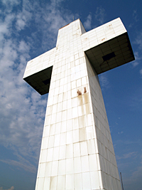
Both cities are centered in the Carbondale-Marion-Herrin, Illinois Combined Statistical Area, home to 123,272 residents. In the southern reaches of the region Alto Pass and Bald Knob Cross are located near the orchards. The large Crab Orchard lake is the largest in the region. Historic Cairo sits at the far southern end near the confluence of the Ohio and Mississippi Rivers.
Population: 158,782
Southeastern Illinois
The least populated region, Southeastern Illinois is marked by being within the Shawnee Hills and the Shawnee National Forest. The area includes many state parks and Garden of the Gods Wilderness. The historic town of Shawneetown is located on the Ohio River which is the eastern border of the region.