
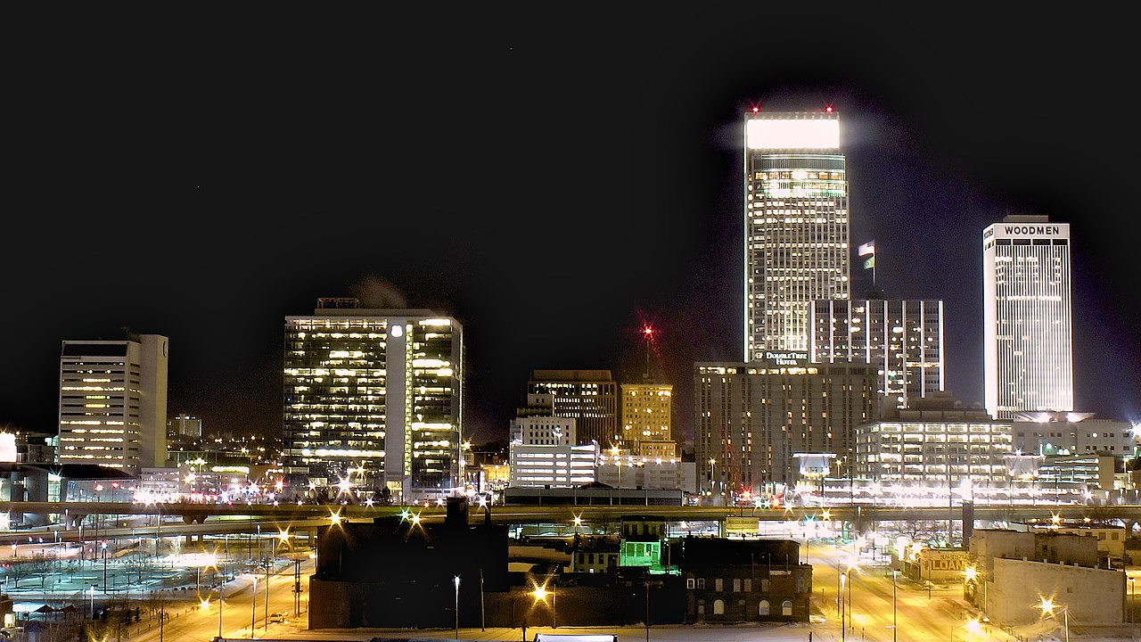
Nebraska ( nə-BRASS-kə) is a triple-landlocked state in the Midwestern region of the United States. It borders South Dakota to the north; Wyoming to the west; Colorado to the southwest; Kansas to the south; and Missouri to the southeast and Iowa to the east, both across the Missouri River. Nebraska is the 16th-largest state by land area, with just over 77,347 square miles (200,330 km2). As of the 2020 census, the population was 1,961,504, and was estimated to be 2,018,006 in 2025, it is the 38th-most populous state and the eighth-least densely populated. Nebraska's capital is Lincoln, and its most populous city is Omaha, which is on the Missouri River.
Nebraska was admitted into the United States in 1867, two years after the end of the American Civil War. The Nebraska Legislature is unlike any other American legislature in that it is unicameral, and its members are elected without any official reference to political party affiliation. Nebraska is one of only two states (Maine being the other) that divide electoral college votes by district, and is not winner-take-all state-wide.
Nebraska is composed of two major land regions: the Dissected Till Plains and the Great Plains. The Dissected Till Plains region consists of gently rolling hills and contains the state's largest cities, Omaha and Lincoln. The Great Plains region, occupying most of western Nebraska, is characterized by treeless prairie. Eastern Nebraska has a humid continental climate while western Nebraska is primarily semi-arid. The state has wide variations between winter and summer temperatures; the variations decrease in southern Nebraska. Violent thunderstorms and tornadoes occur primarily during spring and summer, and sometimes in autumn. The Chinook wind tends to warm the state significantly in the winter and early spring.
Indigenous peoples, including Omaha, Missouria, Ponca, Pawnee, Otoe, and various branches of the Lakota (Sioux) tribes, lived in the region for thousands of years before European discovery and exploration. The state is crossed by many historic trails, including that of the Lewis and Clark Expedition. The completion of the Transcontinental Railroad through Nebraska and passage of the Homestead Acts led to rapid growth in the population of American settlers in the 1870s and 1880s and the development of a large agriculture sector for which the state is known to this day.
Etymology
Nebraska's name is the result of anglicization of the archaic Otoe Ñí Brásge (contemporary Otoe: Ñíbrahge; pronounced [ɲĩbɾasꜜkɛ]), or the Omaha Ní Btháska, (pronounced [nĩbɫᶞasꜜka]), meaning "flat water", after the Platte River which flows through the state.
History
Early history
Indigenous peoples lived in the region of present-day Nebraska for thousands of years before European colonization. The historic tribes in the state included the Omaha, Missouria, Ponca, Pawnee, Otoe, and various branches of the Lakota (Sioux), some of which migrated from eastern areas into the region. When European exploration, trade, and settlement began, both Spain and France sought to control the region. In the 1690s, Spain established trade connections with the Apache, whose territory then included western Nebraska. By 1703, France had developed a regular trade with native peoples along the Missouri River in Nebraska, and by 1719 had signed treaties with several of these peoples. After war broke out between the two countries, Spain dispatched an armed expedition to Nebraska under Lieutenant General Pedro de Villasur in 1720. The party was attacked and destroyed near present-day Columbus by a large force of Pawnee and Otoe, both allied with the French. The massacre ended Spanish exploration of the area for the remainder of the 18th century. In 1762, during the Seven Years' War, France ceded the Louisiana Territory to Spain. This left Britain and Spain competing for dominance along the Mississippi River; by 1773, the British were trading with the native peoples of Nebraska. Spain dispatched two trading expeditions up the Missouri River in 1794 and 1795; the second, under James Mackay, established the first European settlement in Nebraska near the mouth of the Platte River. Later that year, Mackay's party built a trading post, dubbed Fort Carlos IV (Fort Charles), near present-day Homer.
American settlement and statehood
In 1819, the United States established Fort Atkinson as the first U.S. Army post west of the Missouri River, just east of present-day Fort Calhoun. The army abandoned the fort in 1827 as migration moved farther west. European-American settlement was scarce until 1848 and the California Gold Rush. On May 30, 1854, the U.S. Congress created the Kansas and Nebraska territories, divided by the Parallel 40° North, under the Kansas–Nebraska Act. The Nebraska Territory included parts of the modern-day states of Colorado, North Dakota, South Dakota, Wyoming, and Montana. The territorial capital of Nebraska was Omaha.
Late 19th century
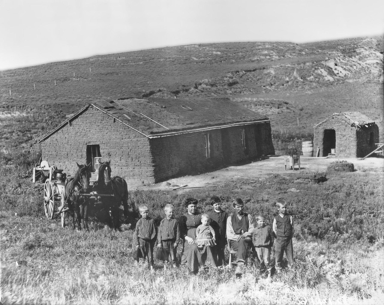
In the 1860s, after the U.S. government forced many of the American Indian tribes to cede their lands and settle on reservations, it opened large tracts of land to agricultural development by European immigrants and American settlers. Under the Homestead Act, thousands of settlers migrated into Nebraska to claim free land granted by the federal government. Because so few trees grew on the prairies, many of the first farming settlers built their homes of sod, as had Native Americans such as the Omaha. The first wave of settlement gave the territory a sufficient population to apply for statehood. Nebraska became the 37th state on March 1, 1867, and the capital was moved from Omaha to the center at Lancaster, later renamed Lincoln after the recently assassinated President of the United States, Abraham Lincoln. The battle of Massacre Canyon, on August 5, 1873, was the last major battle between the Pawnee and the Sioux.
During the 1870s to the 1880s, Nebraska experienced a large growth in population. Several factors contributed to attracting new residents. The first was that the vast prairie land was perfect for cattle grazing. This helped settlers to learn the unfamiliar geography of the area. The second factor was the invention of several farming technologies. New agricultural innovations such as barbed wire, windmills, and the steel plow, combined with fair weather, enabled settlers to transform Nebraska into prime farming land. By the 1880s, Nebraska's population had soared to more than 450,000 people. The Arbor Day holiday was founded in Nebraska City by territorial governor J. Sterling Morton. The National Arbor Day Foundation is still headquartered in Nebraska City, with some offices in Lincoln.
In the late 19th century, African Americans migrated from the South to Nebraska as part of the Great Migration. Eventually, they moved primarily to Omaha which offered working-class jobs in meat packing, the railroads and other industries. Omaha has a long history of civil rights activism. Blacks encountered discrimination from other Americans in Omaha and especially from recent European immigrants who were also competing for the same jobs as well.
20th century
In 1912, African Americans founded the Omaha chapter of the National Association for the Advancement of Colored People to work for improved conditions in the city and state. During the Omaha Race Riots in 1919, many white rioters protested throughout Omaha in response to an incident in which a black man was accused of sexually assaulting a white woman. The Great Depression also greatly affected the residents of Nebraska. From 1930 to 1936 the Dust Bowl, a period of dust storms caused by drought, destruction of topsoil by farming practices, and other factors affected Nebraska along with much of the Midwestern United States. In 1934, voters passed an initiative to make Nebraska's legislature a unicameral body, and the first unicameral session was held in 1937. Kay Orr was elected Nebraska's first female governor on November 4, 1986.
Geography
The state is bordered by South Dakota to the north; Iowa to the east and Missouri to the southeast, across the Missouri River; Kansas to the south; Colorado to the southwest; and Wyoming to the west. It is the only triply landlocked state in the United States. The state has 93 counties and is split between two time zones, with the majority of the state observing Central Time and the Panhandle and surrounding counties observing Mountain Time.

Three rivers cross the state from west to east:
The Niobrara River flows through the northern part of the state, and
The Platte River, formed by the confluence of the North Platte and the South Platte, runs through the state's central portion

The Republican River runs across the southern part.
The first Constitution of Nebraska in 1866 described Nebraska's boundaries as follows:The State of Nebraska shall consist of all the territory included within the following boundaries, to-wit: Commencing at a point formed by the intersection of the western boundary of the State of Missouri, with the fortieth degree of north latitude; extending thence due west along said fortieth degree of north latitude, to a point formed by its intersection with the twenty-fifth degree of longitude west from Washington [the Southern border]; thence north along said twenty-fifth degree of longitude, to a point formed by its intersection with the forty-first degree of north latitude; thence west along said forty-first degree of north latitude to a point formed by its intersection with the twenty-seventh degree of longitude west from Washington; thence north along said twenty-seventh degree of west longitude, to a point formed by its intersection with the forty-third degree of north latitude [the Western border, which is the Panhandle]; thence east along said forty-third degree of north latitude to the Keya Paha river; thence down the middle of the channel of said river, with its meanderings, to its junction with the Niobrara River; thence down the middle of the channel of said Niobrara River, and following the meanderings thereof to its junction with the Missouri River [the Northern border]; thence down the middle of the channel of said Missouri River, and following the meanderings thereof to the place of beginning [the Eastern border, which is the Missouri River].
The description given for the northern border is no longer accurate, since the Keya Paha River and the Niobrara River no longer form the boundary of the state of Nebraska. Instead, Nebraska's northern border now extends east along the forty-third degree of north latitude until it meets the Missouri River directly.

Nebraska is composed of two major land regions, the Dissected Till Plains and the Great Plains. The easternmost portion of the state was scoured by Ice Age glaciers; the Dissected Till Plains were left after the glaciers retreated. The Dissected Till Plains is a region of gently rolling hills; Omaha and Lincoln are in this region. The Great Plains occupy most of western Nebraska, with the region consisting of several smaller, diverse land regions, including the Sandhills, the Pine Ridge, the Rainwater Basin, the High Plains and the Wildcat Hills. Panorama Point, at 5,424 feet (1,653 m), is Nebraska's highest point; though despite its name and elevation, it is a relatively low rise near the Colorado and Wyoming borders. A former tourist slogan for the State of Nebraska was "Where the West Begins", but this has since been changed to "Honestly, it's not for everyone". Locations given for the beginning of the "West" in Nebraska include the Missouri River, the intersection of 13th and O Streets in Lincoln (where it is marked by a red brick star), the 100th meridian, and Chimney Rock.
Federal land management
Areas under the management of the National Park Service include:
Agate Fossil Beds National Monument near Harrison
California National Historic Trail
Chimney Rock National Historic Site near Bayard
Homestead National Monument of America in Beatrice
Lewis and Clark National Historic Trail
Missouri National Recreational River near Ponca
Mormon Pioneer National Historic Trail
Niobrara National Scenic River near Valentine
Oregon National Historic Trail
Pony Express National Historic Trail
Scotts Bluff National Monument at Gering
Areas under the management of the National Forest Service include:
Nebraska National Forest
Oglala National Grassland
Samuel R. McKelvie National Forest
Climate
Two major climatic zones are represented in Nebraska. The eastern two-thirds of the state has a humid continental climate (Köppen Dfa), although the southwest of this region may be classed as a humid subtropical climate (Cfa) using the −3 °C or 26.6 °F near the Kansas state line, analogous to the predominantly humid subtropical climate of Kansas and Oklahoma. Western Nebraska, including the Nebraska Panhandle and adjacent areas bordering Colorado have a semi-arid climate (Köppen BSk). The entire state experiences wide seasonal variations in both temperature and precipitation. Average temperatures are fairly uniform across Nebraska, with hot summers and generally cold winters. However, chinook winds from the Rocky Mountains provide a temporary moderating effect on temperatures in the state's western portion during the winter. Thus, average January maximum temperatures are highest at around 43 °F or 6.1 °C in southwestern Dundy County, and lowest at about 30 °F or −1.1 °C around South Sioux City in the northeast.
Average annual precipitation decreases east to west from about 31.5 inches (800 mm) in the southeast corner of the state to about 13.8 inches (350 mm) in the Panhandle. Humidity also decreases significantly from east to west. Snowfall across the state is fairly even, with most of Nebraska receiving between 25 and 35 inches (0.64 and 0.89 m) of snow each year. Nebraska's highest-recorded temperature was 118 °F (48 °C) in Minden on July 24, 1936. The state's lowest-recorded temperature was −47 °F (−44 °C) in Camp Clarke on February 12, 1899.
Nebraska is located in Tornado Alley. Thunderstorms are common during both the spring and the summer. Violent thunderstorms and tornadoes happen primarily during those two seasons, although they also can occur occasionally during the autumn.
Settlements
Eighty-nine percent of the cities in Nebraska have fewer than 3,000 people. Nebraska shares this characteristic with five other Midwestern states: Kansas, Oklahoma, North Dakota and South Dakota, and Iowa. Hundreds of towns have a population of fewer than 1,000. Regional population declines have forced many rural schools to consolidate.
Fifty-three of Nebraska's 93 counties reported declining populations between 1990 and 2000, ranging from a 0.06% loss (Frontier County) to a 17.04% loss (Hitchcock County).
More urbanized areas of the state have experienced substantial growth. In 2020, the city of Omaha had a population of 486,051 and in 2024, the city's estimated population was 489,265, a 0.7% increased from the 2020 census. In 2020, the city of Lincoln had a population of 291,082 and in 2024, the city's estimated population was 300,619, a 3.3% increased from the 2020 census.
As of the 2020 census, there were 528 cities and villages in the state of Nebraska. There are five classifications of cities and villages in Nebraska, which are based upon population. All population figures are 2024 Census Bureau estimates unless flagged by a reference number.
Metropolitan Class City (400,000 or more)
Omaha 489,265
Primary Class City (100,000–399,999)
Lincoln 300,619
First Class City (5,000–99,999)
Second Class Cities (800–4,999) and Villages (100–799) make up the rest of the communities in Nebraska. There are 116 second-class cities and 382 villages in the state.
Metropolitan areas
Omaha-Council Bluffs 878,138 (Nebraska portion); 1,001,010 (total for Nebraska and Iowa)