
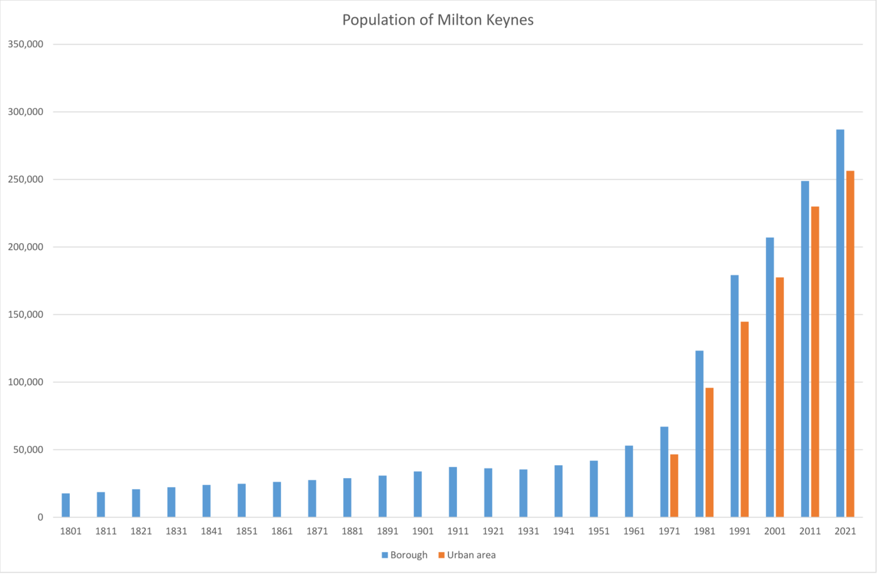
Milton Keynes ( KEENZ) is a city in Buckinghamshire, England, about 50 miles (80 km) north-west of London. At the 2021 census, the population of its urban area was 264,349. The River Great Ouse forms the northern boundary of the urban area; a tributary, the River Ouzel, meanders through its linear parks and balancing lakes. Approximately 25% of the urban area is parkland or woodland, including two Sites of Special Scientific Interest (SSSIs). By design, the city comprises many well-delineated neighbourhoods.
In the 1960s, the government decided that a further generation of new towns in the south east of England was needed to relieve housing congestion in London. Milton Keynes was to be the biggest yet, with a population of 250,000 and area of 22,000 acres (9,000 ha). At designation, its area incorporated the existing towns of Bletchley, Fenny Stratford, Wolverton and Stony Stratford, along with another fifteen villages and farmland in between. These settlements had an extensive historical record since the Norman Conquest; detailed archaeological investigations before development revealed evidence of human occupation from the Neolithic period, including the Milton Keynes Hoard of Bronze Age gold jewellery. The government established Milton Keynes Development Corporation (MKDC) to design and deliver this new city. The Corporation decided on a softer, more human-scaled landscape than in the earlier English new towns but with an emphatically modernist architecture. Recognising how traditional towns and cities had become choked in traffic, they established a grid of distributor roads about 1 km (0.6 mi) between edges, leaving the spaces between to develop more organically. An extensive network of shared-use paths for leisure cyclists and pedestrians criss-crosses through and between them. Rejecting the residential tower block concept that had become unpopular, they set a height limit of three storeys outside Central Milton Keynes.
Facilities include a 1,400-seat theatre, a municipal art gallery, two multiplex cinemas, an ecumenical central church, a 400-seat concert hall, a teaching hospital, a 30,500-seat football stadium, an indoor ski-slope and a 65,000-capacity open-air concert venue. Seven railway stations serve the Milton Keynes urban area (one inter-city). The Open University is based here and there is a small campus of the University of Bedfordshire. Most major sports are represented at amateur level; Red Bull Racing (Formula One), MK Dons (association football), and Milton Keynes Lightning (ice hockey) are its professional teams. The Peace Pagoda overlooking Willen Lake was the first such to be built in Europe. The many works of sculpture in parks and public spaces include the iconic Concrete Cows at Milton Keynes Museum.

Milton Keynes is among the most economically productive localities in the UK, ranking highly across a number of criteria. It has the UK's fifth-highest number of business startups per capita (but equally of business failures). It is home to several major national and international companies. Despite economic success and personal wealth for some, there are pockets of nationally significant poverty. The employment profile is composed of about 90% service industries and 9% manufacturing.
History
Birth of a "new city"
It may startle some political economists to talk of commencing the building of new cities ... planned as cities from their first foundation, and not mere small towns and villages. ... A time will arrive when something of this sort must be done ... England cannot escape from the alternative of new city building.
In the 1960s, the UK government decided that a further generation of new towns in the South East of England was needed to relieve housing congestion in London. Since the 1950s, overspill housing for several London boroughs had been constructed in Bletchley. Further studies in the 1960s identified north Buckinghamshire as a possible site for a large new town, a new city, encompassing the existing towns of Bletchley, Stony Stratford, and Wolverton. The New Town (informally and in planning documents, "New City") was to be the biggest yet, with a target population of 250,000, in a "designated area" of 21,883 acres (8,855.7 ha). The name "Milton Keynes" was taken from that of an existing village on the site.

On 23 January 1967, when the formal "new town designation order" was made, the area to be developed was largely farmland and undeveloped villages. The site was deliberately located equidistant from London, Birmingham, Leicester, Oxford, and Cambridge, with the intention that it would be self-sustaining and eventually become a major regional centre in its own right. Planning control was taken from elected local authorities and delegated to the Milton Keynes Development Corporation (MKDC). Before construction began, every area was subject to detailed archaeological investigation: doing so has exposed a rich history of human settlement since Neolithic times and has provided a unique insight into the history of a large sample of the landscape of North Buckinghamshire.
The corporation's strongly modernist designs were regularly featured in the magazines Architectural Design and the Architects' Journal. MKDC was determined to learn from the mistakes made in the earlier new towns, and revisit the garden city ideals. They set in place the characteristic grid roads that run between districts ("grid squares"), as well as a programme of intensive planting, balancing lakes and parkland. Central Milton Keynes ("CMK") was not intended to be a traditional town centre but a central business and shopping district to supplement local centres embedded in most of the grid squares. This non-hierarchical devolved city plan was a departure from the English new towns tradition and envisaged a wide range of industry and diversity of housing styles and tenures. The largest and almost the last of the British New Towns, Milton Keynes has "stood the test of time far better than most, and has proved flexible and adaptable". The radical grid plan was inspired by the work of Melvin M. Webber, described by the founding architect of Milton Keynes, Derek Walker, as the "father of the city". Webber thought that telecommunications meant that the old idea of a city as a concentric cluster was out of date and that cities which enabled people to travel around them readily would be the thing of the future, achieving "community without propinquity" for residents.
The government wound up MKDC in 1992, 25 years after the new town was founded. Control was transferred to the Commission for New Towns (CNT) and then finally to English Partnerships, with planning functions returning to the local council (Milton Keynes Borough (now City) Council). From 2004 to 2011 a government quango, the Milton Keynes Partnership, had development control powers to accelerate the growth of Milton Keynes.
Formal award of city status
Along with many other towns and boroughs, Milton Keynes competed (unsuccessfully) for formal city status in the 2000, 2002 and 2012 competitions. However the Borough (including rural areas, in addition to the MK urban area) was successful in 2022, in the Queen's Platinum Jubilee Civic Honours competition. On 15 August 2022, the Crown Office in Chancery announced formally that Queen Elizabeth II had ordained by letters patent that the Borough of Milton Keynes has been given city status. In law, it is the Borough rather than its eponymous settlement that has city status; nevertheless it is the latter that is more commonly known as the city.
Name
The name "Milton Keynes" was a reuse of the name of one of the original historic villages in the designated area, now more generally known as "Milton Keynes Village" to distinguish it from the modern settlement. A century after the Norman invasion, the manor transferred by marriage to Hugh de Kaynes, whose family held it to the late 13th century (as well as others in the country – Ashton Keynes in Wiltshire, Somerford Keynes in Gloucestershire, and Horsted Keynes in West Sussex). The village was originally known as Middeltone (11th century); then later as Middelton Kaynes or Caynes (13th century); Milton Keynes (15th century); and Milton alias Middelton Gaynes (17th century).
Prior history
The area that was to become Milton Keynes encompassed a landscape that has a rich historic legacy. The area to be developed was largely farmland and undeveloped villages, but with evidence of permanent settlement dating back to the Bronze Age. Before construction began, every area was subject to detailed archaeological investigation: this work has provided an insight into the history of a very large sample of the landscape of south-central England. There is evidence of Stone Age, late Bronze Age/early Iron Age, Romano-British, Anglo-Saxon, Anglo-Norman, Medieval, and late Industrial Revolution settlements such as the railway towns of Wolverton (with its railway works) and Bletchley (at the junction of the London and North Western Railway with the Oxford–Cambridge Varsity Line). The most notable archaeological artefact was the Milton Keynes Hoard, which the British Museum described as "one of the biggest concentrations of Bronze Age gold known from Britain and seems to flaunt wealth".

Bletchley Park, the site of World War II Allied code-breaking and Colossus, the world's first programmable electronic digital computer, is a major component of MK's modern history. It is now a flourishing heritage attraction, receiving hundreds of thousands of visitors annually.
When the boundary of Milton Keynes was defined in 1967, some 40,000 people lived in four towns and fifteen villages or hamlets in the "designated area".
Geography
Location and nearest settlements
Milton Keynes is in south central England, at the northern end of the South East England region, about 50 miles (80 km) north-west of London.

The nearest large towns are Northampton, Bedford, Luton and Aylesbury. The nearest large cities are Coventry, Leicester, Cambridge, London and Oxford.
Geology
Its surface geology is primarily gently rolling Oxford clay or, more formally:
... a portion of more or less dissected boulder clay plateau, with streams falling fairly steeply to the [Great] Ouse and Ouzel flood plains, across slopes cut chiefly in Oxford clay. Middle Jurassic rocks, in particular the Blisworth limestone and cornbrash, form strong features in the lands bordering the Ouse valley in the north.

Its highest points are in the centre (110 m; 360 ft) and at Woodhill on the western boundary (120 m; 390 ft). The lowest point of the urban area is in Newport Pagnell, where the Ouzel joins the Great Ouse (50 m; 160 ft).
Parks and environmental infrastructure
Because of the (poorly drained) clay soils and the urban hard surfaces, the development corporation identified water runoff into the Ouzel and its tributaries as a significant risk to be managed and so put in place two large balancing lakes (Caldecotte and Willen) and a number of smaller detention ponds. These provide an important leisure amenity for most of the year. Building in the floodplains of the Ouse and Ouzel was precluded too, thus providing long-distance linear parks that are within easy reach of most residents.
The north basin of Willen Lake is a bird sanctuary, with a Peace Pagoda and Buddhist temple by the lake.
The two Sites of Special Scientific Interest, Howe Park Wood and Oxley Mead, are the most significant of a number of important wildlife sites in and around MK.
Just outside the Milton Keynes urban area lies Little Linford Wood, a conservation site and nature reserve managed by the Berkshire, Buckinghamshire and Oxfordshire Wildlife Trust. It is considered to be one of the best habitats for dormice.
Climate
Milton Keynes experiences an oceanic climate (Köppen climate classification Cfb) as is typical of almost all of the United Kingdom.
The nearest Met Office weather station is in Woburn, Bedfordshire, just outside the south eastern fringe of Milton Keynes. Recorded temperature extremes range from 39.6 °C (103.3 °F) during July 2022, to as low as −20.6 °C (−5.1 °F) on 25 February 1947; this is the lowest temperature ever reported in England in February.
Urban design
The radical plan, form and scale of Milton Keynes attracted international attention. Early phases of development include work by celebrated architects, including Sir Richard MacCormac, Norman Foster, Henning Larsen, Ralph Erskine, John Winter, and Martin Richardson. Led by Lord Campbell of Eskan (chairman) and Fred Roche (General Manager), the Corporation attracted talented young architects, led by the respected designer, Derek Walker. In the modernist Miesian tradition is the Shopping Building designed by Stuart Mosscrop and Christopher Woodward, a grade II listed building, which the Twentieth Century Society called the "most distinguished" twentieth century retail building in Britain. The Development Corporation also led an ambitious public art programme.
The urban design has not been universally praised. In 1980, the then president of the Royal Town Planning Institute, Francis Tibbalds, described Central Milton Keynes as "bland, rigid, sterile, and totally boring." Michael Edwards, a member of the original consultancy team, believes that there were weaknesses in their proposal and that the Development Corporation implemented it badly.
Grid roads and grid squares
The Milton Keynes Development Corporation planned the major road layout according to street hierarchy principles, using a grid pattern of approximately 1 km (0.6 mi) intervals, rather than on the more conventional radial pattern found in older settlements. Major distributor roads run between communities, rather than through them: these distributor roads are known locally as grid roads and the spaces between them – the neighbourhoods – are known as grid squares (though few are actually square or even rectilinear). This spacing was chosen so that people would always be within six minutes' walking distance of a grid-road bus-stop. Consequently, each grid square is a semi-autonomous community, making a unique collective of 100 clearly identifiable neighbourhoods within the overall urban environment. The grid squares have a variety of development styles, ranging from conventional urban development and industrial parks to original rural and modern urban and suburban developments. Most grid squares have a local centre, intended as a retail hub, and many have community facilities as well. Each of the original villages is the heart of its own grid-square. Originally intended under the master plan to sit alongside the grid roads, these local centres were mostly in fact built embedded in the communities.
Although the 1970 master plan assumed cross-road junctions, roundabout junctions were built at intersections because this type of junction is more efficient at dealing with small to medium volumes. Some major roads are dual carriageway, the others are single carriageway. Along one side of each single carriageway grid road, there is usually a (grassed) reservation to permit dualling or additional transport infrastructure at a later date. As of 2018, this has been limited to some dualling. The edges of each grid square are landscaped and densely planted – some additionally have noise attenuation mounds – to minimise traffic noise from the grid road impacting the adjacent grid square. Traffic movements are fast, with relatively little congestion since there are alternative routes to any particular destination other than during peak periods. The national speed limit applies on the grid roads, although lower speed limits have been introduced on some stretches to reduce accident rates. Pedestrians rarely need to cross grid roads at grade, as underpasses and bridges were specified at frequent places along each stretch of all of the grid roads. In contrast, the later districts planned by English Partnerships have departed from this model, without a road hierarchy but with conventional junctions with traffic lights and at grade pedestrian crossings.
Redways
There is a separate network (approximately 170 miles (270 km) total length) of cycle and pedestrian routes – the redways – that runs through the grid-squares and often runs alongside the grid-road network. This was designed to segregate slow moving cycle and pedestrian traffic from fast moving motor traffic. In practice, it is mainly used for leisure cycling rather than commuting, perhaps because the cycle routes are shared with pedestrians, cross the grid-roads via bridge or underpass rather than at grade, and because some take meandering scenic routes rather than straight lines. It is so called because it is generally surfaced with red tarmac. The national Sustrans national cycle network routes 6 and 51 take advantage of this system.
Height
The original design guidance declared that commercial building heights in the centre should not exceed six storeys, with a limit of three storeys for houses (elsewhere), paraphrased locally as "no building taller than the tallest tree". In contrast, the Milton Keynes Partnership, in its expansion plans for Milton Keynes, believed that Central Milton Keynes (and elsewhere) needed "landmark buildings" and subsequently lifted the height restriction for the area. As a result, high rise buildings have been built in the central business district. As of 2014, local plans have protected the existing boulevard framework and set higher standards for architectural excellence.
Linear parks
The floodplains of the Great Ouse and of its tributaries (the Ouzel and some brooks) have been protected as linear parks that run right through Milton Keynes; these were identified as important landscape and flood-management assets from the outset. At 4,100 acres (1,650 ha) – ten times larger than London's Hyde Park and a third larger than Richmond Park – the landscape architects realised that the Royal Parks model would not be appropriate or affordable and drew on their National Park experience. As Bendixson and Platt (1992) write: "They divided the Ouzel Valley into 'strings, beads and settings'. The 'strings' are well-maintained routes, be they for walking, bicycling or riding; the 'beads' are sports centres, lakeside cafes and other activity areas; the 'settings' are self-managed land-uses such as woods, riding paddocks, a golf course and a farm".
The Grand Union Canal is another green route (and demonstrates the level geography of the area – there is just one minor lock in its entire 10-mile (16 km) meandering route through from the southern boundary near Fenny Stratford to the "Iron Trunk" aqueduct over the Ouse at Wolverton at its northern boundary).
The initial park system was planned by Peter Youngman (Chief Landscape Architect), who also developed landscape precepts for all development areas: groups of grid squares were to be planted with different selections of trees and shrubs to give them distinct identities. The detailed planning and landscape design of parks and of the grid roads was evolved under the leadership of Neil Higson, who from 1977 took over from Youngman.
In a national comparison of urban areas by open space available to residents, Milton Keynes ranked highest in the UK. Milton Keynes is unusual in that most of the parks are owned and managed by a charity, the Milton Keynes Parks Trust rather than the local authority, to ensure that the management of the city's green spaces is largely independent of the council's expenditure priorities.
Forest city concept
The Development Corporation's original design concept aimed for a "forest city" and its foresters planted millions of trees from its own nursery in Newlands in the following years. Parks, lakes and green spaces cover about 25% of Milton Keynes; as of 2018, there are 22 million trees and shrubs in public open spaces. When the Development Corporation was being wound up, it transferred the major parks, lakes, river-banks and grid-road margins to the Parks Trust, a charity which is independent of the municipal authority. MKDC endowed the Parks Trust with a portfolio of commercial properties, the income from which pays for the upkeep of the green spaces. As of 2018, approximately 25% of the urban area is parkland or woodland. It includes two Sites of Special Scientific Interest, Howe Park Wood and Oxley Mead.
Centre
As a key element of the planners' vision, Milton Keynes has a purpose built centre, with a very large "covered high street" shopping centre,
a theatre, municipal art gallery, a multiplex cinema, hotels, central business district, an ecumenical church, Milton Keynes Civic Offices and central railway station.
Campbell Park, a formal park extending east from the business area to the Grand Union Canal, is described in the Pevsner Architectural Guides as "...the largest and most imaginative park to have been laid out in Britain in the 20th century". The park is listed (grade 2) by Historic England,
Original towns and villages
Milton Keynes consists of many pre-existing towns and villages that anchored the urban design, as well as new infill developments. The modern-day urban area outside the original six towns (Bletchley, Fenny Stratford, Newport Pagnell, Stony Stratford, Wolverton, and Woburn Sands) was largely rural farmland but included many picturesque North Buckinghamshire villages and hamlets: Bradwell village and its Abbey, Broughton, Caldecotte, Great Linford, Loughton, Milton Keynes Village, New Bradwell, Shenley Brook End, Shenley Church End, Simpson, Stantonbury, Tattenhoe, Tongwell, Walton, Water Eaton, Wavendon, Willen, Great and Little Woolstone, Woughton on the Green. These historical settlements were made the focal points of their respective grid square. Every other district has an historical antecedent, if only in original farms or even field names.
Bletchley was first recorded in the 12th century as Blechelai. Its station was an important junction (the London and North Western Railway with the Oxford-Cambridge Varsity Line), leading to the substantial urban growth in the town in the Victorian period. It expanded to absorb the village of Water Eaton and town of Fenny Stratford.
Bradwell is a traditional rural village with earthworks of a Norman motte and bailey and parish church. Bradwell Abbey, a former Benedictine Priory and scheduled monument, was of major economic importance in this area of North Buckinghamshire before its dissolution in 1524. Nowadays there is only a small medieval chapel and a manor house occupying the site. New Bradwell, to the north of Bradwell and east of Wolverton, was built specifically for railway workers. The level bed of the old Wolverton to Newport Pagnell Line near here has been converted to a redway, making it a favoured route for cycling. A working windmill is sited on a hill outside the village.