
Greater Sudbury (French: Grand Sudbury), also known as Sudbury, is the most populous city in Northern Ontario with a population around 166,004 in 2021. Greater Sudbury is the only single-tier municipality in Northern Ontario, the largest city in Ontario by area and the fifth largest in Canada. The city is separate from, but entirely surrounded by, the Sudbury District.
The Sudbury region was inhabited by the Ojibwe people of the Algonquin group of the Anishinaabe prior to the founding of Sudbury after the discovery of nickel and copper ore in 1883 during the construction of the Canadian Pacific Railway. Greater Sudbury was formed in 2001 by merging the cities and towns of the former Regional Municipality of Sudbury with several previously unincorporated townships. Being located inland, the local climate is extremely seasonal, with average January lows of around −18 °C (0 °F) and average July highs of 25 °C (77 °F).
The population resides in an urban core and many smaller communities scattered around 330 lakes and among hills of rock blackened by historic smelting activity. Sudbury was once a major lumber center and a world leader in nickel mining. Mining and related industries dominated the economy for much of the 20th century. The two major mining companies which shaped the history of Sudbury were Inco, now Vale Limited, which employed more than 25% of the population by the 1970s, and Falconbridge, now Glencore. Sudbury has since expanded from its resource-based economy to emerge as the major retail, economic, health, and educational center for Northeastern Ontario. Sudbury is also home to a large Franco-Ontarian population, which influences its arts and culture.
Toponymy
James Worthington, the superintendent of construction on the Northern Ontario segment of the railway, selected the name Sudbury after Sudbury, Suffolk, in England, which was the hometown of his wife Caroline Hitchcock.
The city's official name was changed to Greater Sudbury in 2001, when it was amalgamated with its suburban towns into the current city, on the grounds of ensuring that the merger did not erase the longstanding community identities of the outlying towns. In everyday usage, however, the city is still more commonly referred to as just Sudbury.
History
The original name for the region was N'Swakamok, which translates to 'where the three roads meet' in the Ojibwe language. The Sudbury region was home to by Ojibwe people, an Anishinaabeg group, as early as 9,000 years ago following the retreat of the last continental ice sheet.
In 1850, local Ojibwe chiefs entered into an agreement with the British Crown to share a large tract of land, including what is now Sudbury, as part of the Robinson Huron Treaty. In exchange the Crown pledged to pay an annuity to First Nations people, which was originally set at $1.60 per treaty member and increased incrementally; its last increase was in 1874, leaving it fixed at $4.
French Jesuits were the first to establish a European settlement when they set up a mission called Sainte-Anne-des-Pins, just before the construction of the Canadian Pacific Railway in 1883. The Sainte-Anne-des-Pins church played a prominent role in the development of Franco-Ontarian culture in the region. Coincidentally, Ste-Anne is the patron saint of miners.
During construction of the railway in 1883, blasting and excavation revealed high concentrations of nickel-copper ore at Murray Mine on the edge of the Sudbury Basin. This discovery brought the first waves of European settlers, who arrived not only to work at the mines, but also to build a service station for railway workers. Provincial land surveyor JL Morris laid out the intersection of Elm Street and Durham Street in 1884 as he planned the township.
Rich deposits of nickel sulphide ore were discovered in the Sudbury Basin geological formation. The construction of the railway allowed exploitation of these mineral resources and shipment of the commodities to markets and ports, as well as large-scale lumber extraction. In 1886 the Canadian Copper Company and others besides had been formed with the idea to exploit the region's natural wealth, and by 1888 the Copper Cliff smelter was born.
Sudbury was incorporated as a town in 1893, and its first mayor was Joseph Étienne aka Stephen Fournier.
The American inventor Thomas Edison visited the Sudbury area as a prospector in 1901. He is credited with the original discovery of the ore body at Falconbridge.

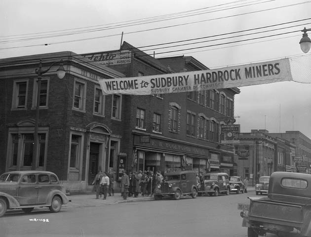
Mining began to replace lumber as the primary industry as the area's transportation network was improved to include trams. These enabled workers to live in one community and work in another. Sudbury's economy was dominated by the mining industry for much of the 20th century. Two major mining companies were created: Inco in 1902 and Falconbridge in 1928. They became two of the city's major employers and two of the world's leading producers of nickel.
Through the decades that followed, Sudbury's economy went through boom and bust cycles as world demand for nickel fluctuated. Demand was high during the First World War, when Sudbury-mined nickel was used extensively in the manufacturing of artillery in Sheffield, England. It bottomed out when the war ended and then rose again in the mid-1920s as peacetime uses for nickel began to develop. The town was reincorporated as a city in 1930.
The city recovered from the Great Depression much more quickly than almost any other city in North America due to increased demand for nickel in the 1930s. Sudbury was the fastest-growing city and one of the wealthiest cities in Canada for most of the decade. Many of the city's social problems in the Great Depression era were not caused by unemployment or poverty, but due to the difficulty in keeping up with all of the new infrastructure demands created by rapid growth — for example, employed mineworkers sometimes ended up living in boarding houses or makeshift shanty towns, because demand for new housing was rising faster than supply. Between 1936 and 1941, the city was ordered into receivership by the Ontario Municipal Board. Another economic slowdown affected the city in 1937, but the city's fortunes rose again with wartime demands during the Second World War. The Frood Mine alone accounted for 40 percent of all the nickel used in Allied artillery production during the war. After the end of the war, Sudbury was in a good position to supply nickel to the United States government when it decided to stockpile non-Soviet supplies during the Cold War.

The open coke beds used in the early to mid-20th century and logging for fuel resulted in a near-total loss of native vegetation in the area. Consequently, the terrain was made up of exposed rocky outcrops permanently stained charcoal black by the air pollution from the roasting yards. Acid rain added more staining, in a layer that penetrates up to 3 in (76 mm) into the once pink-grey granite.
In 1969 a white paper circulated about local Indigenous issues. The N'Swakamok Native Friendship Centre was founded in 1972 to address these concerns and provide support for the local Indigenous community.
The construction of the Inco Superstack in 1972 dispersed sulphuric acid through the air over a much wider area, reducing the acidity of local precipitation. This enabled the municipality, province and Inco and academics from Laurentian University to begin an environmental recovery program in the late 1970s, labelled a "regreening" effort. Lime was spread over the charred soil by hand and by aircraft. Seeds of wild grasses and other vegetation were also spread. As of 2010, 9.2 million new trees have been planted in the city. Vale has begun to rehabilitate the slag heaps that surrounds their smelter in the Copper Cliff area with the planting of grass and trees, as well as the use of biosolids to stabilize and regreen tailings areas.

In 1978, the workers of Sudbury's largest mining corporation, Inco (now Vale), embarked on a strike over production and employment cutbacks. The strike, which lasted for nine months, badly damaged Sudbury's economy. The city government was spurred to launch a project to diversify the city's economy.
A unique and visionary project, Science North was inaugurated in 1984 with two-snowflake styled buildings connected by a tunnel through the Canadian shield where the Creighton fault intersects the shores of Lake Ramsey. The city tried to attract new employers and industries through the 1980s and 1990s with mixed success. The city of Sudbury and its suburban communities, which were reorganized into the Regional Municipality of Sudbury in 1973, was subsequently merged in 2001 into the single-tier city of Greater Sudbury.
In 2006, both of the city's major mining companies, Canadian-based Inco and Falconbridge, were taken over by new owners: Inco was acquired by the Brazilian company CVRD (now renamed Vale), while Falconbridge was purchased by the Swiss company Xstrata, which itself was purchased by Anglo–Swiss Glencore, forming Glencore Xstrata. Xstrata donated the historic Edison Building, the onetime head office of Falconbridge, to the city in 2007 to serve as the new home of the municipal archives. On September 19, 2008, a fire destroyed the historic Sudbury Steelworkers Hall on Frood Road. A strike at Vale's operations, which began on July 13, 2009, was tentatively resolved in July 2010. The 2009 strike lasted longer than the devastating 1978 strike, but had a much more modest effect on the city's economy than the earlier action—unlike in 1978, the local rate of unemployment declined slightly during the 2009 strike.
The ecology of the Sudbury region has recovered dramatically, helped by regreening programs and improved mining practices. The United Nations honoured twelve cities in the world, including Sudbury, with the Local Government Honours Award at the 1992 Earth Summit to recognise the city's community-based environmental reclamation strategies. By 2010, the regreening programs had successfully rehabilitated 3,350 ha (8,300 acres) of land in the city; however, approximately 30,000 ha (74,000 acres) of land have yet to be rehabilitated.
Various studies have confirmed that the provincial government's initial claims that the municipal amalgamation would result in cost savings and increased efficiencies have not borne out, and in fact administration of the amalgamated city costs significantly more than the prior regional government structure did.
Geography
Sudbury has 330 lakes over 10 ha (25 acres) in size within the city limits. The most prominent is Lake Wanapitei, one of the largest lakes in the world that is completely contained within a municipality. Ramsey Lake, a few kilometres south of downtown Sudbury, held a similar status before the municipal amalgamation in 2001 brought Lake Wanapitei fully inside the city limits. Sudbury is divided into two main watersheds: to the east is the French River watershed which flows into Georgian Bay, and to the west is the Spanish River watershed, which flows into the North Channel of Lake Huron.
Sudbury is built around many small, rocky mountains with exposed igneous rock of the Canadian (Precambrian) Shield. The ore deposits in Sudbury are part of a large geological structure, known as the Sudbury Basin, which are the remnants of a nearly two billion-year-old impact crater; long thought to be the result of a meteorite collision, though more recent analysis has suggested that the crater may in fact have been created by a comet.
Sudbury's pentlandite, pyrite and pyrrhotite ores contain profitable amounts of many elements—primarily nickel and copper, but also platinum, palladium and other valuable metals.
Local smelting of the ore releases this sulphur into the atmosphere where it combines with water vapour to form sulphuric acid, contributing to acid rain. As a result, Sudbury has had a widespread reputation as a wasteland. In parts of the city, vegetation was devastated by acid rain and logging to provide fuel for early smelting techniques. To a lesser extent, the area's ecology was also impacted by lumber camps providing wood for the reconstruction of Chicago after the Great Chicago Fire of 1871. While other logging areas in Northeastern Ontario were also involved in that effort, the emergence of mining-related processes in the following decade made it significantly harder for new trees to grow to full maturity in the Sudbury area than elsewhere.
The resulting erosion exposed bedrock in many parts of the city, which was charred in most places to a pitted, dark black appearance. There was not a complete lack of vegetation in the region, as paper birch and wild blueberry patches thrived in the acidic soils. During the Apollo crewed lunar exploration program, NASA astronauts trained in Sudbury to become familiar with impact breccia and shatter cones, rare rock formations produced by large meteorite impacts. However, the popular misconception that they were visiting Sudbury because it purportedly resembled the lifeless surface of the Moon persists.
Conservation Sudbury operates a conservation area, the Lake Laurentian Conservation Area, in the city's south end. Other unique environmental projects in the city include the Fielding Bird Sanctuary, a protected area along Highway 17 near Lively that provides a managed natural habitat for birds, and a hiking and nature trail near Coniston, which is named in honour of scientist Jane Goodall.
Six provincial parks (Chiniguchi River, Daisy Lake Uplands, Fairbank, Killarney Lakelands and Headwaters, Wanapitei and Windy Lake) and two provincial conservation reserves (MacLennan Esker Forest and Tilton Forest) are also located partially or entirely within the city boundaries.
Climate
Greater Sudbury has a humid continental climate (Köppen climate classification: Dfb). This region has warm and often humid summers with occasional short lasting periods of hot weather, with long, cold and snowy winters. It is situated north of the Great Lakes, making it prone to arctic air masses. Monthly precipitation is equal year round, with snow cover expected for up to six months of the year. Although extreme weather events are rare, one of the worst tornadoes in Canadian history struck the city and its suburbs on August 20, 1970, killing six people, injuring two hundred, and causing more than C$17 million (equivalent to $138 million in 2025) in damages.
The highest temperature ever recorded in Greater Sudbury was 41.1 °C (106.0 °F) on July 13, 1936. The lowest temperature ever recorded was −48.3 °C (−54.9 °F) on December 29, 1933.
Communities
The city of Sudbury and its suburban communities were reorganized into the Regional Municipality of Sudbury in 1973, which was subsequently merged in 2001 into the single-tier city of Greater Sudbury.
In common usage, the city's urban core is still generally referred to as Sudbury, while the outlying former towns are still referred to by their old names and continue in some respects to maintain their own distinct community identities despite their lack of political independence. Each of the seven former municipalities in turn encompasses numerous smaller neighbourhoods. Amalgamated cities (2001 Canadian census population) include: Sudbury (85,354) and Valley East (22,374). Towns (2001 Canadian census population) include: Rayside-Balfour (15,046), Nickel Centre (12,672), Walden (10,101), Onaping Falls (4,887), and Capreol (3,486). The Wanup area, formerly an unincorporated settlement outside of Sudbury's old city limits, was also annexed into the city in 2001, along with a large wilderness area on the northeastern shore of Lake Wanapitei.
Demographics
In the 2021 Census of Population conducted by Statistics Canada, Greater Sudbury had a population of 166,004 living in 71,476 of its 75,967 total private dwellings, a change of 2.8% from its 2016 population of 161,531. With a land area of 3,186.26 km2 (1,230.22 sq mi), it had a population density of 52.1/km2 (134.9/sq mi) in 2021.
At the census metropolitan area (CMA) level in the 2021 census, the Greater Sudbury CMA had a population of 170,605 living in 73,387 of its 78,225 total private dwellings, a change of 2.8% from its 2016 population of 165,958. With a land area of 4,187.4 km2 (1,616.8 sq mi), it had a population density of 40.7/km2 (105.5/sq mi) in 2021.
In 2011, the population of Sudbury was less educated than the Canadian average, with 17.2% of the population holding a university degree (compared to 23.3% nationally) and 18.1% with no certificate, diploma or degree (compared to 17.3% nationally).
In 2021, the median age was 43.2 years, slightly higher than the provincial average of 41.6 years.
Ethnicity
Greater Sudbury has few visible minorities with 6.6% reporting visible minority status on the 2021 census compared to the national average of 26.5%, but a much higher percentage of Indigenous Canadians (11%) than the national average of 5%. Visible minorities representing over 0.5% of the population include: 2.5% Black, 1.9% South Asian, and 0.6% Chinese.
Note: Totals greater than 100% due to multiple origin responses.
Religion
According to the 2021 census profile, the residents of Greater Sudbury are predominantly Christian. Around 64% (down from 81% in 2011) of the population belongs to Christian denominations with Catholics composing the largest single group (47%, down from 59% in 2011). Those with no religious affiliation accounted for 33% (up from 18% in 2011) of the population. Other religions such as Islam, Judaism, and Hinduism constitute around 3% of the population in total, up from 1% in 2011.
Language
Sudbury is a bilingual city with a large francophone population, with 37.5% of Sudburians able to speak French and 22.6% having French as mother tongue. 83.8% of the population use English as the language spoken most often at home, followed by French at 10.6%, which is significantly higher than the Ontario average of 1.8%.
Economy
After a brief period as a lumber camp, Sudbury's economy was dominated by the mining industry for much of the 20th century. By the 1970s, Inco employed a quarter of the local workforce. However, in 2006, Inco and Falconbridge were taken over by foreign multinational corporations: Inco was acquired by the Brazilian company Vale, and Falconbridge was purchased by the Swiss company Xstrata which was in turn purchased by Anglo–Swiss Glencore forming Glencore Xstrata. Several other mining companies, including First Nickel and KGHM, also have mining operations in the Sudbury area.
Mining now employs only 6,000 people in the city, although the mining supply and service sector employs a further 10,000. By 2006, 80% of Greater Sudbury's labour force was employed in services with 20% remaining in manufacturing. Over 345 mining supply and service companies are located in Sudbury. This includes a number of public and private firms pursuing research and development in new mining technologies such as Mining Innovation Rehabilitation and Applied Research Corporation (MIRARCO), the Northern Center for Advanced Technology (NORCAT), and the Centre for Excellence in Mining Innovation (CEMI).
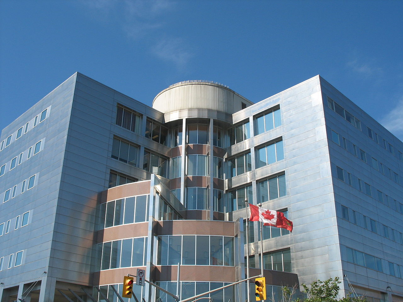
While mining has decreased in relative importance, Sudbury's economy has diversified to establish itself as a major centre of finance, business, tourism, health care, education, government, and science and technology research. Many of these reflect Sudbury's position as a regional service center for Northeastern Ontario, a market of 550,000 people.
The top employers in Sudbury as of November 2010 include:
Many retail businesses in the city have moved outside of the downtown core in the late 20th century and the city has struggled to rebuild and maintain a vibrant downtown core. In the 2000s and early 2010s, projects aimed at revitalizing the downtown core included the creation of Market Square, a farmer's and craft market; the redevelopment of the Rainbow Center Mall; streetscape beautification projects; the conversion of several underutilized historic properties into mixed-use office and loft developments; and the establishment and launch of the McEwen School of Architecture, as well as cultural events such as Downtown Rotary Blues for Food, Sudbury's Largest Yard and Sidewalk Sale, Downtown Sudbury Ribfest and the Up Here art and music festival. New projects underway in the late 2010s include Place des Arts, a performing and visual arts center; and the redesign and renovation of the central plaza at Tom Davies Square.
Despite these efforts, a large percentage of the city's retail service sector is still found outside of the downtown core, in areas such as the Four Corners, the RioCan and Silver Hills power centres on the Kingsway, and the New Sudbury Centre, the largest shopping mall in Northern Ontario with 110 stores.
Film industry
Sudbury has an emerging film and television industry, with a number of projects filming in the city in the 2000s. Development of an active film and television production industry in Northern Ontario was initially undertaken by Cinéfest, the city's largest annual film festival, in the early 1990s, and is currently overseen by Music and Film in Motion, a non-profit organization based in Sudbury.