
North Wales (Welsh: Gogledd Cymru [ˈɡɔɡlɛð ˈkəmrɨ]) is a region of Wales, encompassing its northernmost areas. It borders mid Wales to the south, England to the east, and the Irish Sea to the north and west. The area is highly mountainous and rural, with Snowdonia National Park (Parc Cenedlaethol Eryri) and the Clwydian Range and Dee Valley (Bryniau Clwyd a Dyffryn Dyfrdwy), known for its mountains, waterfalls and trails, wholly within the region. Its population is concentrated in the north-east and northern coastal areas, with significant Welsh-speaking populations in its western and rural areas. North Wales is imprecisely defined, lacking any exact definition or administrative structure. It is commonly defined administratively as its six most northern principal areas, but other definitions exist, with Montgomeryshire historically considered to be part of the region.
Those from North Wales are sometimes referred to as "Gogs" (from Welsh gogledd 'north'); in turn, those from South Wales are sometimes called "Hwntws" by those from North Wales.
The region includes the localities of Wrexham, Deeside, Rhyl, Colwyn Bay, Flint, Bangor, Llandudno, and Holyhead. The largest localities in North Wales are the city of Wrexham and the conurbations of Deeside and Rhyl/Prestatyn, where the main retail, cultural, educational, tourism, and transport infrastructure and services of North Wales are located. Bangor and St Asaph are the region's cities, Bangor is Wales's oldest city, whereas St Asaph is one of Wales's smallest and was awarded status in 2012. Wrexham, the region's largest settlement, became a city in 2022.

History
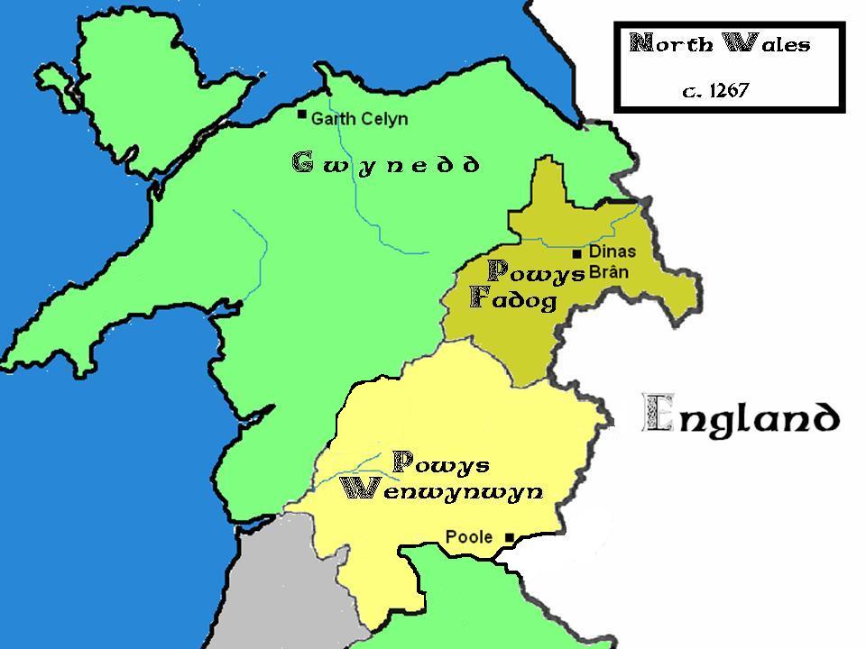
Historically, for most of North Wales, the region can be referred to as simply "Gwynedd", named after one of the last independent Welsh kingdoms, the Kingdom of Gwynedd. This has led to a stronger sense of Welsh identity and home to more Welsh-language speakers, especially in North West Wales, than the rest of Wales. The term "North Wales" is rarely applied to all of Wales during the Anglo-Saxon invasion of Britain and the period of the Heptarchy, to distinguish it from "West Wales", known today as Cornwall, although the term "Wales" or the names of the various petty kingdoms of Wales (Gwynedd, and Powys in North Wales) are more commonly used to depict the region during this time.
The region is steeped in history, being a crucial component in Welsh medieval history, and was from the 5th to the 12th/13th centuries under the control of the influential Welsh kingdoms of Gwynedd, and Powys following the end of Roman rule in Britain. The Kingdom of Gwynedd controlled the majority of what is now the commonly defined 6 counties of North Wales, including all of the North Wales coast, with Powys retaining control over what is modern Powys, and parts of Wrexham and Flintshire, in addition to part of Shropshire. Through their over 800 year existences', their rulers acclaimed themselves to be the "King(s) of the Britons", and Gwynedd would lead the charge in the subsequent formation of the Principality of Wales. The mountainous stronghold of Snowdonia formed the nucleus of that realm and would become the last redoubt of independent Medieval Wales — only overcome in 1283 by English forces under Edward I. To this day it remains a stronghold of the Welsh language and a centre for Welsh national and cultural identity.
World Heritage & Biosphere Sites
The area is home to three of the four UNESCO World Heritage Sites in Wales. These are Pontcysyllte Aqueduct and Canal, the Slate Landscape of Northwest Wales and, collectively, the Edwardian castles and town walls of the region which comprise those at Caernarfon, Beaumaris, Conwy and Harlech. It also shares with Powys and Ceredigion the distinction of hosting the only UNESCO Biosphere (from Man and Biosphere (MAB) Programme to promote sustainable development) reserve in Wales, namely, Biosffer Dyfi Biosphere. London has only one more site than North Wales.

Definition
There is no generally agreed definition of the boundaries and status of North Wales are undefined, and the boundary of North Wales with South or Mid Wales differs between organisations. It is strongly used culturally for comparison to the more urban South Wales. The most common definition for statistical and administrative purposes of North Wales consists of the six principal areas of: Isle of Anglesey, Conwy, Denbighshire, Flintshire, Gwynedd, and Wrexham. These have a combined estimated population in 2018 of 698,400 people. Under this definition, the area borders the principal areas of Ceredigion, Powys, and the rest of Wales to the south, England and its counties of Shropshire, and Cheshire to the east, and the Irish Sea to the north and west. Other definitions, especially historical, commonly include Montgomeryshire, one of the historic counties of Wales, to be part of North Wales, although as part of Powys it is more commonly considered Mid Wales today. The definitions of North and Mid Wales constantly overlap, with Meirionnydd (southern part of the modern principal area of Gwynedd) sometimes considered Mid Wales.
Capitalisation
North Wales may also be spelled as 'north Wales' with a lower case 'n' for north, coined as the "to cap or not to cap" debate. It is argued that using a lower case 'n' is to be only used to signify "north" as merely a geographic identifier, and a capital 'N' to distinctly separate the region for cultural, organisational, or statistical purposes from the rest of Wales. Such usage may follow ideological lines, with North Wales used to promote the region as a distinct entity separate from the rest of Wales, whilst north Wales is merely the northern bit of Wales. Organisations which administer the region together with the rest of Wales, may prefer to use a lower case for "north"; whilst organisations only operating in the region either alone or separately from the rest of Wales may use a capitalised N. Local newspapers, such as the Daily Post describe themselves as a "capper", capitalising the 'N', whereas other organisations such as BBC News may use a lower case. The Welsh Government's style guide uses lowercase, whereas Visit Wales uses capitalised. David Williams, chairman of the North Wales Business Club, announced his support for capping the term "North", saying that North Wales should be a "very recognisable region in our own right".
Principal areas
For local administration purposes, the region is most commonly made up of the following six principal areas: the Isle of Anglesey, Conwy County Borough, Denbighshire, Flintshire, Gwynedd, and Wrexham County Borough.
These principal areas are commonly divided into two groups, used for local news (e.g. BBC), regional tourism boards, town and country planning, and were the proposed replacements to the existing 6 principal areas before proposals were scrapped in 2019. They are:
North East Wales (Denbighshire, Flintshire, Wrexham), and
North West Wales (Anglesey, Conwy, Gwynedd).

However a North Central Wales (Conwy and Denbighshire) grouping has been occasionally used, specifically for health administration.
The population, density and areas are estimates for 2024 from the Office for National Statistics.
Historical divisions
In addition to the six principal areas, North Wales is also divided into the following preserved counties for various ceremonial purposes: Clwyd (comprising Conwy, Denbighshire, Flintshire and Wrexham), and Gwynedd (comprising Gwynedd and Isle of Anglesey) The preserved counties are based on the counties created by the Local Government Act 1972 and were used for local government purposes (with county councils) between 1974 and 1996. During this period up to the present, Montgomeryshire remained a part of Powys.

Prior to the preserved counties, there were counties, now referred to as historic counties. These are the oldest of the counties of North Wales, used for centuries. North Wales contained six historic counties: Anglesey, Caernarfonshire, Denbighshire, Flintshire, Merionethshire, and Montgomeryshire. The most notable difference between these six counties and the present six (seven with Montgomeryshire) is that Caernarfonshire and Merionethshire were combined into one principal area, initially called 'Caernarfonshire and Merionethshire' until a day after its formation where it took the name Gwynedd instead, and the formation of two county boroughs, Conwy carved out of Caernarfonshire and Denbighshire, and Wrexham carved out of Denbighshire and Flintshire.
Although the boundaries of local kingdoms or principalities fluctuated, the north of Wales was divided into three regions during the Middle Ages:
Upper Gwynedd (or Gwynedd above the Conwy), defined as the area north of the River Dyfi and west of the River Conwy
Lower Gwynedd (or Gwynedd below the Conwy), also known as the Perfeddwlad ("the middle country") and defined as the region east of the River Conwy and west of the River Dee; and
Ynys Môn (or Anglesey), a large island off the north-west coast.
English Maelor, currently part of Wrexham County Borough, located east of the River Dee, was (as the name suggests) part of England during a significant part of this period.
Electoral divisions
North Wales is electorally divided into constituencies and electoral wards to elect local representatives to multiple layers of government.
Parliamentary constituencies
Since 2026, four Senedd (Welsh Parliament; Welsh: Senedd Cymru) constituencies have covered North Wales: Bangor Conwy Môn, Clwyd, Fflint Wrecsam, and Gwynedd Maldwyn.
Before the May 2026 Senedd election, there were eleven constituencies used for the Senedd that covered North Wales: Aberconwy, Alyn and Deeside, Arfon, Clwyd South, Clwyd West, Delyn, Dwyfor Meironnydd, Montgomeryshire (if considered North Wales), Vale of Clwyd, Wrexham and Ynys Môn. Additionally there was an electoral region for the Senedd, used to share the name "North Wales", yet it did not cover all of North Wales. The rest of North Wales was covered by the Mid and West Wales Senedd electoral region.
Since 2024, there are eight UK Parliament constituencies: Alyn and Deeside, Bangor Aberconwy, Clwyd East, Clwyd North, Dwyfor Meirionnydd, Montgomeryshire and Glyndŵr (if considered North Wales), Wrexham and Ynys Môn.
Between 1979 and 1994, all of North Wales (including Montgomery) was a single European Parliament constituency (EPC), the North Wales European Parliament Constituency. In 1994, minor border changes put parts of Montgomeryshire in the neighbouring Mid and West Wales constituency. In 1999, both of the constituencies ceased, when it was absorbed into the larger Wales constituency until 2020 when it was subsequently abolished following the United Kingdom's withdrawal from the European Union on 31 January 2020.
Border to the south
The division with the rest of Wales is arbitrary and depends on the particular use being made. For example, the boundary of North Wales Police differs from the boundary of the North Wales area of the Natural Resources Wales and the North Wales Regional Transport Consortium (Taith). The historic boundary follows the pre-1996 county boundaries of Merionethshire and Denbighshire which in turn closely follow the geographic features of the River Dyfi to Aran Fawddwy, then crossing the high moorlands following the watershed until reaching Cadair Berwyn and then following the River Rhaeadr and River Tanat to the Shropshire border. The most common definition is that North Wales ends at the peripheries of the northern 6 principal areas, therefore the border is between Wrexham - Powys, Denbighshire - Powys, Gwynedd - Powys, and Gwynedd - Ceredigion (over the River Dyfi).
Geography
The area is mostly rural, with many mountains and valleys. This, in combination with its coast (on the Irish Sea), means tourism is the principal industry. Farming, which was once the principal economic force in the area, is now much reduced in importance. The average income per capita of the local population is the lowest in the UK.
The eastern part of North Wales contains the most populous areas, with more than 300,000 people living in the areas around Wrexham and Deeside. Wrexham, with a population of 65,692 at the 2011 census in its built-up area, is North Wales's largest city. The total population of North Wales is 696,300 (2017). The majority of other settlements are along the coast, including some popular resort towns, such as Rhyl, Llandudno, Pwllheli, Prestatyn and Tywyn. There are two cathedral cities: Bangor and St Asaph; and a number of medieval castles (e.g. Criccieth, Dolbadarn, Dolwyddelan, Harlech, Caernarfon Castle, Beaumaris, Conwy). The area of North Wales is about 6,172 square kilometres.
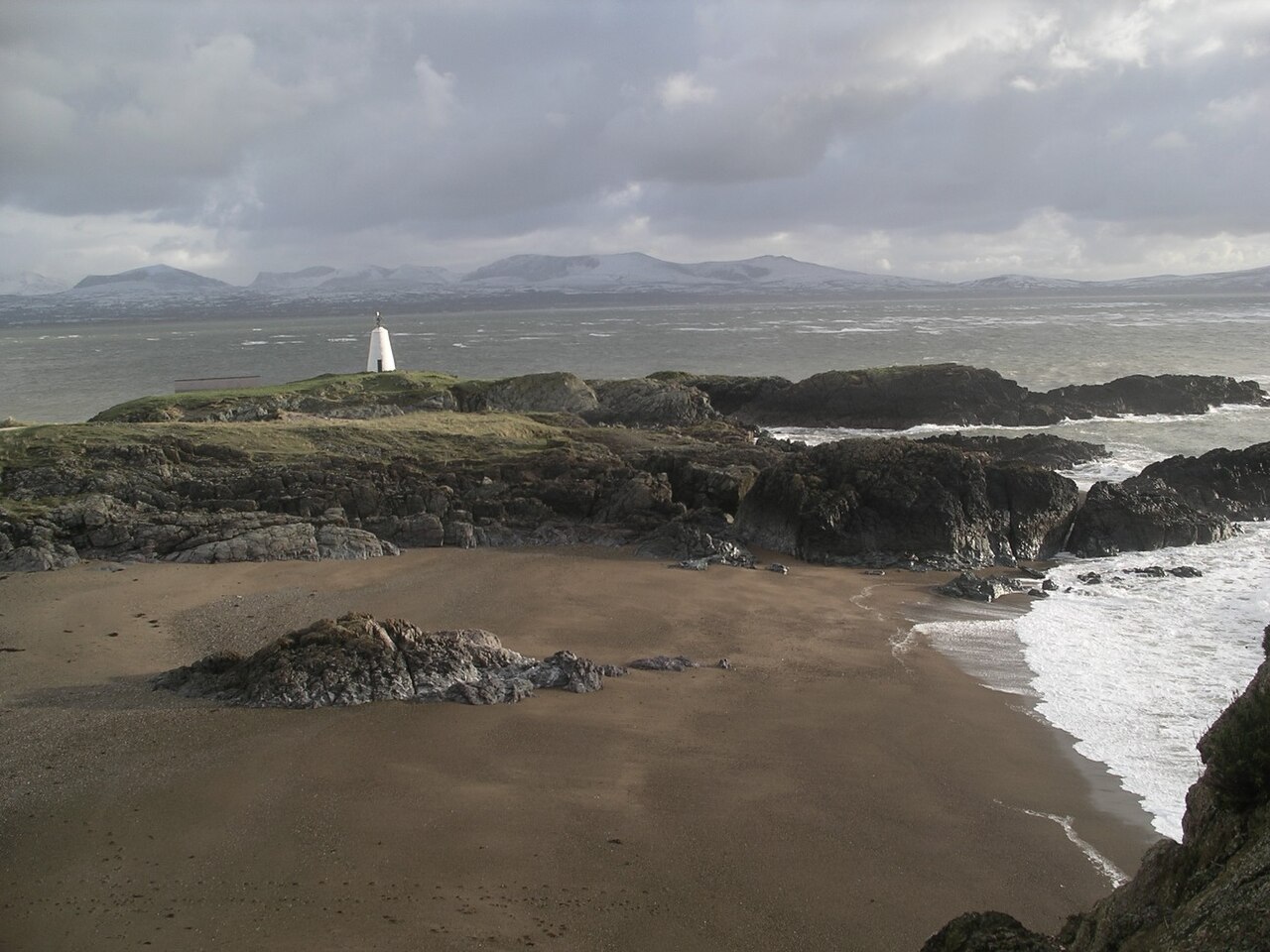
The highest mountain in Wales is Snowdon (Yr Wyddfa), in northwest Wales.
Transport
Roads
North Wales does not have any motorways, with the only motorways in Wales being present in South Wales, and nearest motorways (M53 and M56) being on the other side of the Wales-England border. There have been proposals to upgrade the A55 into a motorway or have more motorway-like features. Trunk roads in the region are maintained by the North and Mid Wales Trunk Road Agent (NMWTRA).
The main roads spanning across North Wales, mostly span east to west, especially along the North Wales coast. This is mainly due to the mountainous terrain in the middle of Wales, leading most north-south connections to be slower, leading to diversions onto north-south roads in England. The emphasis on east-west roadways has led to North Wales having closer connections with North West England (centred on Liverpool and Manchester) rather than with South Wales.
The busiest road in North Wales is the A55, the "North Wales Expressway", a dual carriageway primary road connecting Chester to Holyhead, along the North Wales coast and passing Deeside, Llandudno Junction, Conwy, and Bangor. It is described as the economic lifeline for North Wales, and the second most important road in all of Wales, only to the M4 in South Wales. The road connects all the way to the Port of Holyhead following an extension in 2001, which provides ferry connections to the Republic of Ireland. The majority of the road is part of the E-road network as E22 (until Ewloe, where it goes along the A494 into England), and is a dual carriageway, grade-separated, for its entire 88-mile length.
A historically important road in the region is the A5, a major road that was the primary link between the region and London (as the "London-Holyhead Trunk Road"). The road crosses the Menai Suspension Bridge and is regarded as a more scenic route, with its historical importance as a connection between London and the Port of Holyhead, superseded by the A55. Other roads transiting North Wales, from east to west include the A458 from Halesowen to Mallwyd, and the A494 from Dolgellau to Saughall (originally to Birkenhead).
The busiest north-south road travelling through the region is the A483 from Chester (originally from Manchester) through Wrexham and into England near Oswestry, before re-entering Montgomeryshire and passing Welshpool and Newtown, before continuing onto Swansea. Other major north-south roads include the single-carriageways of the A470 from Llandudno to Cardiff via the Conwy valley, and the A487 from Bangor to Haverfordwest via Caernarfon and Snowdonia.
Sea
The Port of Holyhead, on the isle of Anglesey, is the main commercial and ferry port in North Wales. The port had the third-largest volume of freight traffic, in Wales, in 2018 (5.2 million tonnes), after Milford Haven and Port Talbot, and it is the main port for freight and sea passenger transport with the Republic of Ireland, handling more than 2 million passengers each year. 81% of freight traffic going through Welsh ports to the Republic of Ireland, and 75.5% of sea passenger traffic between Wales and the Republic of Ireland went through Holyhead in 2018. Historically, there were two routes between Holyhead and the Irish ports of Dublin and Dun Laoghaire. The route to Dun Laoghaire was the most popular in 1998 with over 1.7 million passengers ferried, however following a consistent decline in passenger traffic, it was removed in 2015. The other route to Dublin saw an overall increase in passenger numbers from just over 1 million in 1998 to just over 1.9 million in 2018, an increase of 82%.
A Mostyn-Dublin ferry service once existed, on the now Liverpool-Dublin route, attracting a peak of 48,000 passengers in 2003, before being discontinued in 2004.
Rail
The public rail network of the region is largely split into two sections. These sections are centred around the two main west-east railway lines transversing the region, as there are currently no north-south railway lines wholly in the region. This is largely due to the mountainous regions of Snowdonia resting between the two lines, and low passenger numbers of north-south lines leading to their closure. The public rail network is managed and maintained by Network Rail. Historically, the region had a more extensive rail network with more interconnectivity of the current lines and more connections to the south. However, due to falling passenger numbers, the emergence of automobiles and other factors, the region's railways came under review, resulting in the Beeching cuts to the network. Many former rail corridors of the once more extensive network were superseded by road infrastructure. The numerous heritage railways scattered across the region serve as a reminder of the former railways across the region.
The majority of lines operated in Wales are part of the Wales & Borders franchise, the current operator is Transport for Wales Rail, a Welsh-Government owned company, although some services (from Holyhead and Wrexham) are operated by the West Coast Partnership operator, Avanti West Coast on services using the West Coast Main Line to London Euston.
According to StatsWales, the number of rail journeys across the 6 principal areas of North Wales, made in 2017-18 was 1.4 million, an increase of 20,525 from 2007-8. The largest share of these rail journeys, at 38.4%, was within the boundaries of Gwynedd. Conwy was the principal area which saw the greatest increase in rail journeys as a percentage of journeys over the ten-year period, at 22.5%. The least amount of rail journeys in 2018-19 was in Anglesey.
As of 2025, there as 66 rail stations within the boundaries of the 6 northern principal areas, of which 2 are among the 20 busiest stations in Wales, Rhyl, and Bangor. 41 of the rail stations are stations of the North Wales lines, whereas the remaining 25 are stations of the Mid Wales lines, specifically the Cambrian Line. There is a total of 5 rail routes in North Wales: the North Wales Coast Line, the Shrewsbury—Chester Line, the Conwy Valley Line, the Borderlands Line (all part of the North Wales lines) and the Cambrian Line. All 5 routes together in 2023-24 had approximately 5,657,746 entries and exits through the 66 stations.
The North Wales Coast Line, the main rail line serving the north Wales coast, and connecting with Irish Ferries and Stena Line ferry services to Dublin Port in the Republic of Ireland. The Conwy Valley Line branches off at Llandudno Junction, heading north to Llandudno and south to Blaenau Ffestiniog. The Shrewsbury—Chester line, connects Chester and Shrewsbury via Wrexham, providing the main north Wales and south Wales connection. A former open-access operator Wrexham & Shropshire, used to provide a Wrexham General—London Marylebone service until 2011. The Borderlands Line, intersects the Shrewsbury—Chester line at Wrexham General, branching south to Wrexham Central (where it terminates), and north to Bidston (Birkenhead), and the North Wales Coast Line at Shotton. Bidston connects to the Wirral line, providing Merseyrail services, west to West Kirby, and east to Liverpool Central. The Cambrian Line forms the other west-east line in the region (as the Mid-Wales line), it connects Shrewsbury, westwards with Mid Wales and towns along Cardigan Bay. The line is commonly split into two sections, the section from Shrewsbury to Aberystwyth is sometimes referred to as the Cambrian Main Line, with the Cambrian Coast Line, splitting off from this line at Dovey Junction, heading northwest to Pwllheli. The Welsh Marches Line connects Crewe to Newport, via Shrewsbury, with services from Holyhead usually continuing to Cardiff Central. It forms part of the North Wales South Wales service, along with the Shrewsbury—Chester, North Wales Coast Line, and South Wales Main Line. These lines form the main rail connection between North Wales and South Wales.
Chester provides the main travel connections for the North Wales Coast, as a major transport hub. As part of the North Wales Metro, from Chester (and Wrexham General at limited times), via the Halton Curve, direct trains run to Liverpool Lime Street, linking to the Merseyrail. Services to Manchester Piccadilly from Chester, via the Chester—Manchester line for Transport for Wales services, and the Mid—Cheshire line for Northern services, in addition to the Northern service to Leeds, provide North Wales's connections to Northern England. Shrewsbury provides the main travel connections for passengers from the Cambrian Line (and those commuting south from other North Wales stations), providing services, in addition to those to South Wales, through England to Crewe, Birmingham International, and Birmingham New Street, and via the Heart of Wales line, services to Llanelli.
Heritage and narrow gauge railway lines
There are numerous heritage railways in the region. Most of them are narrow-gauge. Several run on sections of historically longer lines. Heritage railways employ more than 300 people and generate over £50 million per year for the North Wales economy.
The heritage railways in the region are: