
The Arabian Peninsula, or simply Arabia, is a peninsula in West Asia. It accounts for the majority of the land situated on the Arabian plate. With an area of 3,237,500 km2 (1.25 million mi2), it is the world's largest peninsula—roughly comparable in size to India. Nine countries are located on the Arabian Peninsula: Bahrain, Kuwait, Oman, Qatar, Saudi Arabia, the United Arab Emirates, and Yemen, as well as the southern halves of Iraq and Jordan.
Geographically, the Arabian Peninsula is bounded by Mesopotamia and the Levant to the north and northwest and therewithal surrounded by the Indian Ocean: the Persian Gulf, the Strait of Hormuz, and the Gulf of Oman to the east and northeast; the Arabian Sea to the southeast; and the Gulf of Aden to the south, the Strait of Mandeb to the southwest, and the Red Sea to the west. Prior to the 7th century AD, Greco-Roman conceptions of "Arabia" were broader than the modern peninsula and extended into the Southern Levant, including the Sinai, the Negev, and regions of modern Jordan, as reflected in the Roman province of Arabia Petraea, whose capital was Petra. In this context, Sinai formed part of a wider regional classification rather than an isolated extension of the peninsula, despite being partly separated from it by the Gulf of Aqaba and situated on the African plate. Most of the peninsula is covered by the Arabian Desert, which is an extension of the Sahara Desert.
Between 56 and 23 million years ago, the peninsula was formed as a result of the Red Sea Rift involving the African and Arabian plates. It was among the first regions to be occupied by modern humans following their departure from Africa during the Paleolithic. The historical record of the Arabian Peninsula is thought to have begun in the early 1st millennium BC, when writing systems were introduced to the region. For much of the peninsula's ancient history, it was sparsely populated by Arab tribes and home to a variety of local and foreign religious practices, while numerous empires and kingdoms exercised limited political authority in different areas. However, in the 7th century AD, the entire Arabian Peninsula was politically, culturally, and religiously united by the Arab leader Muhammad after he claimed prophethood and founded Islam, thus enabling the Arabization of many non-Arab civilizations throughout much of Asia and Africa.

While the Greco-Roman world had known the Arabian Peninsula in three large regions—Petraea for the north, Deserta for the centre, and Felix for the south—medieval Muslim geographers instead divided it into four main regions: the Central Plateau (Najd and Al-Yamama), South Arabia (Yemen, Hadhramaut, and southwestern Oman), Al-Bahrain (Eastern Arabia or Al-Hassa), and the Hejaz (Tihamah for the western coast). Since the 20th century, it has been of critical significance in both Arab and global geopolitics due to the discovery and subsequent industrialization of vast reserves of oil and natural gas. Most of the peninsula's countries are petrocracies and accordingly play a key role in the petroleum politics defining the contemporary Middle East.
Etymology
In antiquity, the term "Arabia" encompassed a larger area than the current term "Arabian Peninsula" and included the Arabian Desert and large parts of the Syrian–Arabian desert. During the Hellenistic period, the area was known as Arabia (Ancient Greek: Ἀραβία). The Romans named three regions "Arabia":
Arabia Petraea ('Stony Arabia'): it consisted of the former Nabataean Kingdom in the southern Levant, the Sinai Peninsula and north-western Arabian Peninsula. It was the only one that became a province, with Petra (in Jordan) as its capital.

Arabia Deserta ('Desert Arabia'): signified the desert lands of Arabia. As a name for the region, it remained popular into the 19th and 20th centuries, and was used in Charles M. Doughty's Travels in Arabia Deserta (1888).
Arabia Felix ('Fortunate Arabia'): was used by geographers to describe the southern part of the Arabian Peninsula, mostly what is now Yemen, which enjoys more rainfall, is much greener than the rest of the peninsula and has long enjoyed much more productive fields.
One of the nomes of Ptolemaic Egypt was named Arabia.

Arabians used a north–south division of Arabia: ash-Sham vs. al-Yaman, or Arabia Deserta vs. Arabia Felix. Arabia Felix had originally been used for the whole peninsula, and at other times only for the southern region. Because its use became limited to the south, the whole peninsula was simply called Arabia. Arabia Deserta was the entire desert region extending north from Arabia Felix to Palmyra and the Euphrates, including all the area between Pelusium on the Nile and Babylon. This area was also called Arabia and not sharply distinguished from the peninsula.
The Arabs and the Ottoman Empire considered the west of the Arabian Peninsula region where the Arabs lived 'the land of the Arabs'—bilad al-'Arab (Arabia), and its major divisions were the bilad al-Sham (Syria), bilad al-Yaman (Yemen), and bilad al-'Iraq (Iraq). The Ottomans used the term Arabistan in a broad sense for the region starting from Cilicia, where the Euphrates river makes its descent into Syria, through Palestine, and on through the remainder of the Sinai and Arabian peninsulas.
The provinces of Arabia were: al-Tih, the Sinai Peninsula, Hejaz, Asir, Yemen, Hadramaut, Mahra and Shilu, Oman, Hasa, Bahrain, Dahna, Nufud, the Hammad, which included the deserts of Syria, Mesopotamia and Babylonia.

Geography
The Arabian Peninsula is located in the continent of Asia and is bounded by (clockwise) the Persian Gulf to the north-east, the Strait of Hormuz and the Gulf of Oman to the east, the Arabian Sea to the south-east, the Gulf of Aden and the Guardafui Channel to the south, and the Bab-el-Mandeb strait to the south-west and the Red Sea to the south-west and west.
The northern portion of the peninsula transitions into the Syrian Desert with no clear borderline, although the northern boundary of the peninsula is generally considered to be the northern borders of Saudi Arabia and Kuwait, as well as the southern regions of Iraq and Jordan.
The most prominent feature of the peninsula is the desert, but in the south-west, there are mountain ranges, which receive greater rainfall than the rest of the peninsula. Harrat ash Shaam is a large volcanic field that extends from north-western Arabia into Jordan and southern Syria.
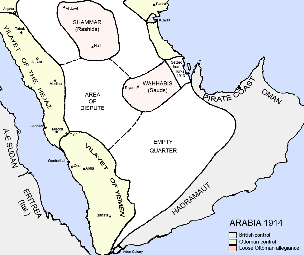
Political boundaries
The Peninsula's constituent countries are (clockwise from north to south) Kuwait, Qatar, and the United Arab Emirates (UAE) in the east, Oman in the south-east, Yemen in the south, and Saudi Arabia at the center. The island country of Bahrain lies just off the east coast of the Peninsula, to the northwest of Qatar. Due to Yemen's jurisdiction over the Socotra Archipelago, the Peninsula's geopolitical outline faces the Guardafui Channel and the Somali Sea to the south.
The six countries of Bahrain, Kuwait, Oman, Qatar, Saudi Arabia, and the UAE form the Gulf Cooperation Council (GCC).
The Kingdom of Saudi Arabia covers the largest part of the Peninsula. The Peninsula contains the world's largest oil reserves. Saudi Arabia and the UAE are economically the wealthiest in the region. Qatar, the only peninsular country in the Persian Gulf on the larger peninsula, is home to the Arabic television station Al Jazeera and its English-language subsidiary Al Jazeera English. Kuwait, on the border with Iraq, is an important country strategically, forming one of the main staging grounds for coalition forces mounting the United States–led 2003 invasion of Iraq.
Population
Despite its historically sparse population, political Arabia stands out for its rapid population growth, driven by both significant inflows of migrant labor and persistently high birth rates. The population is characterized by its relative youth and a heavily skewed gender ratio favoring males. In several states, the number of South Asians surpasses that of the native population.
The four smallest states by area, with coastlines entirely bordering the Persian Gulf, showcase the world's most extreme population growth, nearly tripling every two decades. In 2014, the estimated population of the Arabian Peninsula was 77,983,936, including expatriates.
The Arabian Peninsula is known for having one of the most uneven adult sex ratios in the world, with females in some regions, especially the east, constituting only a quarter of people aged between 20 and 40.
Cities
The ten most populous cities in the Arabian Peninsula are:
Landscape
The rocks exposed vary systematically across Arabia, with the oldest rocks exposed in the Arabian-Nubian Shield near the Red Sea, overlain by earlier sediments that become younger towards the Persian Gulf. Perhaps the best-preserved ophiolite on Earth, the Samail Ophiolite, lies exposed in the mountains of the UAE and northern Oman.
The peninsula consists of:
A central plateau, the Najd, with fertile valleys and pastures used for the grazing of sheep and other livestock
A range of deserts: the Nefud in the north, which is stony; the Rub' al Khali or Great Arabian Desert in the south, with sand estimated to extend 600 ft (180 m) below the surface; between them, the Dahna Mountains
Stretches of dry or marshy coastline with coral reefs on the Red Sea side (Tihamah)
Oases and marshy coast-land in Eastern Arabia, the most important of which are those of the Al Ain emirate (Tawam region) and Hofuf/Al-Ahsa (in modern-day Saudi Arabia), according to an author
The south-west monsoon coastline of Dhofar and Eastern Yemen (Mahra).
Arabia has few lakes or permanent rivers. Most areas are drained by ephemeral watercourses called wadis, which are dry except during the rainy season. Plentiful ancient aquifers exist beneath much of the peninsula, however, and where this water surfaces, oases form (e.g. Al-Hasa and Qatif, two of the world's largest oases) and permit agriculture, especially palm trees, which allowed the peninsula to produce more dates than any other region in the world.
In general, the climate is extremely hot and arid, although there are exceptions. Higher elevations are made temperate by their altitude, and the Arabian Sea coastline can receive cool, humid breezes in summer due to cold upwelling offshore. The peninsula has no thick forests. Desert-adapted wildlife is present throughout the region.
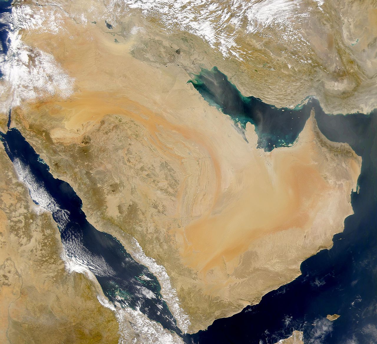
A plateau more than 2,500 feet (760 m) high extends across much of the Arabian Peninsula. The plateau slopes eastwards from the massive, rifted escarpment along the coast of the Red Sea, to the shallow waters of the Persian Gulf. The interior is characterized by cuestas and valleys, drained by a system of wadis. A crescent of sand and gravel deserts lies to the east.
Mountains
There are mountains at the eastern, southern and north-western borders of the peninsula. Broadly, the ranges can be grouped as follows:
North-east: The Hajar range, of UAE and Oman
South-east: The Dhofar Mountains of southern Oman, contiguous with the eastern Yemeni Hadhramaut
West: Bordering the eastern coast of the Red Sea are the Sarawat, which can be seen to include the Haraz Mountains to the east of Yemen, as well as those of 'Asir (once part of Yemen) and Hejaz the latter including the Midian in what is now north-western Saudi Arabia
North-west: Aside from the Sarawat, the northern portion of Saudi Arabia hosts the Jabal Shamar Mountains, which include the Aja and Salma subranges
Central: The Najd hosts the Tuwaiq Escarpment or Tuwair range
From the Hijaz southwards, the mountains show a steady increase in altitude westward as they get nearer to Yemen, and the highest peaks and ranges are all located in Yemen. The highest, Jabal An-Nabi Shu'ayb or Jabal Hadhur of the Haraz subrange of the Sarawat range, is 3,666 metres (12,028 ft) high. By comparison, the Tuwayr, Shammar and Dhofar generally do not exceed 1,000 m (3,300 ft) in height.
Not all mountains in the peninsula are visibly within ranges. Jebel Hafeet in particular, on the border of the UAE and Oman, measuring between 1,100 and 1,300 m (3,600 and 4,300 ft), is not within the Hajar range, but may be considered an outlier of that range.
Land and sea
Most of the Arabian Peninsula is unsuited to agriculture, making irrigation and land reclamation projects essential. The narrow coastal plain and isolated oases, amounting to less than 1% of the land area, are used to cultivate grains, coffee and tropical fruits. Goat, sheep, and camel husbandry is widespread elsewhere throughout the rest of the Peninsula.
Some areas have a summer humid tropical monsoon climate, in particular the Dhofar and Al Mahrah areas of Oman and Yemen. These areas allow for large scale coconut plantations. Much of Yemen has a tropical monsoon rain influenced mountain climate. The plains usually have either a tropical or subtropical arid desert climate or arid steppe climate.
The sea surrounding the Arabian Peninsula is generally tropical with a very rich sea life and some of the world's largest and most pristine coral reefs. The protozoa and zooxanthellae living in symbiosis with Red Sea corals have a unique hot weather adaptation to sudden rise and fall in sea water temperature. Hence, these coral reefs are not affected by coral bleaching caused by rise in temperatures, as Indo-Pacific coral reefs are.
The reefs are also unaffected by mass tourism and diving or other large scale human interference. The Persian gulf has suffered significant loss and degradation of coral reefs with the biggest ongoing threat believed to be coastal construction activity altering the marine environment.
The fertile soils of Yemen have encouraged settlement of almost all of the land from sea level up to the mountains at 10,000 feet (3,000 m). In the higher elevations, elaborate terraces have been constructed to facilitate grain, fruit, coffee, ginger and khat cultivation. The Arabian peninsula is known for its rich oil, i.e. petroleum production due to its geographical location.
According to NASA's Gravity Recovery and Climate Experiment (GRACE) satellite data (2003–2013) analysed in a University of California, Irvine (UCI)-led study published in Water Resources Research in June 2015, the most over-stressed aquifer system in the world is the Arabian Aquifer System, upon which more than 60 million people depend for water. Twenty-one of the 37 largest aquifers "have exceeded sustainability tipping points and are being depleted" and thirteen of them are "considered significantly distressed".
History
Prehistoric Arabia
Prehistoric Arabia is the period of the Arabian Peninsula before any written records are known, going back to when humans first began to settle in the region, until around 1000 BC, when systematic written documentation begins to appear in the archaeological record. Stone tools from the Middle Paleolithic era along with fossils of other animals discovered at Ti's al Ghadah, in north-western Saudi Arabia, might imply that hominins migrated through a "Green Arabia" between 300,000 and 500,000 years ago.
Two-hundred-thousand-year-old stone tools were discovered at Shuaib Al-Adgham in the eastern Al-Qassim Province, which would indicate that many prehistoric sites, located along a network of rivers, had once existed in the area. Acheulean tools found in Sadaqah, Riyadh Region reveal that hominids lived in the Arabian Peninsula around 188,000 years ago. Human habitation in Arabia may have occurred as early as 130,000 years ago. A fossilized Homo sapiens finger bone found at Al Wusta in the Nefud Desert dates to approximately 90,000 years ago and is the oldest human fossil discovered outside of Africa and the Levant. This indicates human migrations from Africa to Arabia occurred around this time.
The Arabian Peninsula may have been the homeland of a 'Basal Eurasian' population, which diverged from other Eurasians soon after the Out-of-Africa migration, and subsequently became isolated, until it started to mix with other populations in the Middle East around 25,000 years ago. These different Middle Eastern populations would later spread Basal Eurasian ancestry via the Neolithic Revolution to all of Western Eurasia.
Pre-Islamic Arabia
Archaeology has revealed the existence of many civilizations in pre-Islamic Arabia (such as the Thamud), especially in South Arabia. South Arabian civilizations include the Kingdom of Saba, Awsan, Ma'in, and Himyar. From 106 AD to 630 AD north-western Arabia was under the control of the Roman Empire, which renamed it Arabia Petraea. Central Arabia was the location of the Kingdom of Kinda in the 4th, 5th and early 6th centuries, as well as the Ma'add tribes. Eastern Arabia was home to the Dilmun civilization. The earliest known events in Arabian history are migrations from the peninsula into neighbouring areas.