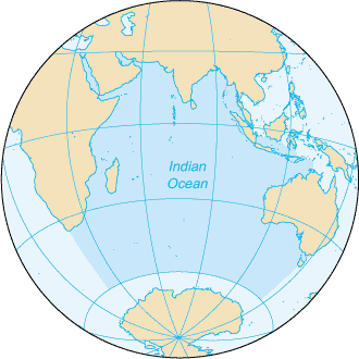
The Indian Ocean is the third-largest of the world's five oceanic divisions, covering 70,560,000 km2 (27,240,000 sq mi) or approximately 20% of the water area of Earth's surface. It is bounded by Asia to the north, Africa to the west and Australia to the east. To the south it is bounded by the Southern Ocean or Antarctica, depending on the definition in use. The Indian Ocean has large marginal or regional seas, including the Andaman Sea, the Arabian Sea, the Bay of Bengal, and the Laccadive Sea.
Geologically, the Indian Ocean is the youngest of the oceans (being directly preceded by the Tethys Ocean, which fragmented into the Mediterranean Sea and the Indian Ocean only 20 million years ago), and it has distinct features such as narrow continental shelves. Its average depth is 3,741 m. It is the warmest ocean, with a significant impact on global climate due to its interaction with the atmosphere. Its waters are affected by the Indian Ocean Walker circulation, resulting in unique oceanic currents and upwelling patterns. The Indian Ocean is ecologically diverse, with important ecosystems such as coral reefs, mangroves, and seagrass beds. It hosts a significant portion of the world's tuna catch and is home to endangered marine species. The climate around the Indian Ocean is characterized by monsoons.
The Indian Ocean has been a hub of cultural and commercial exchange since ancient times. It played a key role in early human migrations and the spread of civilizations. In modern times, it remains crucial for global trade, especially in oil and hydrocarbons. Environmental and geopolitical concerns in the region include climate change, overfishing, pollution, piracy, and disputes over island territories.
Etymology
The Indian Ocean has been known by its present name since at least 1515, when the Latin form Oceanus Orientalis Indicus (lit. 'Indian Eastern Ocean') is attested, named after India, which projects into it. It was earlier known as the Eastern Ocean, a term that was still in use during the mid-18th century, as opposed to the Western Ocean (Atlantic) before the Pacific was surmised. The modern Hindi name for the Ocean is हिंद महासागर (Hind Mahāsāgar; lit. transl. Ocean of India).
Conversely, Chinese explorers (e.g., Zheng He during the Ming dynasty) who traveled to the Indian Ocean during the 15th century called it the Western Oceans.
In Ancient Greek geography, the Indian Ocean region known to the Greeks was called the Erythraean Sea.
In traditional South Asian geography, the ocean is historically called the "Mahodadhi", divided into the two seas Purvapayodhi (sunrise) and Apara (sunset).
Geography
Extent and data
The borders of the Indian Ocean, as delineated by the International Hydrographic Organization in 1953, included the Southern Ocean but not the marginal seas along the northern rim. In 2002 the IHO delimited the Southern Ocean separately, which removed waters south of 60°S from the Indian Ocean but included the northern marginal seas.
Meridionally, the Indian Ocean is delimited from the Atlantic Ocean by the 20° east meridian, running south from Cape Agulhas, South Africa, and from the Pacific Ocean by the meridian of 146°49'E, running south from South East Cape on the island of Tasmania in Australia. The northernmost extent of the Indian Ocean (including marginal seas) is approximately 30°N in the Persian Gulf.
The Indian Ocean covers 70,560,000 km2 (27,240,000 sq mi), including the Red Sea and the Persian Gulf but excluding the Southern Ocean, or 19.5% of the world's oceans. Its volume is 264,000,000 km3 (63,000,000 cu mi) or 19.8% of the world's oceans' volume; it has an average depth of 3,741 m (12,274 ft) and a maximum depth of 7,290 m (23,920 ft).
All of the Indian Ocean is in the Eastern Hemisphere. The centre of the Eastern Hemisphere, the 90th meridian east, passes through the Ninety East Ridge.
Within these waters are a number of islands. These include those controlled by surrounding countries, and independent island states and territories. Of the non-coastal islands, there are two broad clusters: one around Madagascar, and one south of India. A few other oceanic islands are scattered elsewhere.
Coasts and shelves
In contrast to the Atlantic and Pacific, the Indian Ocean is enclosed by major landmasses and an archipelago on three sides and does not stretch from pole to pole, and can be likened to an embayed ocean. It is centered on the Indian Peninsula. Although this subcontinent has played a significant role in its history, the Indian Ocean has foremostly been a cosmopolitan stage, interlinking diverse regions by innovations, trade, and religion since early in human history.
The active margins of the Indian Ocean have an average width (horizontal distance from land to shelf break) of 19 ± 0.61 km (11.81 ± 0.38 mi) with a maximum width of 175 km (109 mi). The passive margins have an average width of 47.6 ± 0.8 km (29.58 ± 0.50 mi).
The average width of the slopes (horizontal distance from shelf break to foot of slope) of the continental shelves are 50.4–52.4 km (31.3–32.6 mi) for active and passive margins respectively, with a maximum width of 205.3–255.2 km (127.6–158.6 mi).
In correspondence of the Shelf break, also known as Hinge zone, the Bouguer gravity ranges from 0 to 30 mGals that is unusual for a continental region of around 16 km thick sediments. It has been hypothesized that the "Hinge zone may represent the relict of continental and proto-oceanic crustal boundary formed during the rifting of India from Antarctica."
Australia, Indonesia, and India are the three countries with the longest shorelines and exclusive economic zones. The continental shelf makes up 15% of the Indian Ocean.
More than two billion people live in countries bordering the Indian Ocean, compared to 1.7 billion for the Atlantic and 2.7 billion for the Pacific (some countries border more than one ocean).
Rivers
The Indian Ocean drainage basin covers 21,100,000 km2 (8,100,000 sq mi), virtually identical to that of the Pacific Ocean and half that of the Atlantic basin, or 30% of its ocean surface (compared to 15% for the Pacific). The Indian Ocean drainage basin is divided into roughly 800 individual basins, half that of the Pacific, of which 50% are located in Asia, 30% in Africa, and 20% in Australasia. The rivers of the Indian Ocean are shorter on average (740 km (460 mi)) than those of the other major oceans. The largest rivers are (order 5) the Zambezi, Ganges-Brahmaputra, Indus, Jubba, and Murray rivers and (order 4) the Shatt al-Arab, Wadi Ad Dawasir (a dried-out river system on the Arabian Peninsula) and Limpopo rivers. After the breakup of East Gondwana and the formation of the Himalayas, the Ganges-Brahmaputra rivers flow into the world's largest delta known as the Bengal delta or Sunderbans.
Marginal seas
Marginal seas, gulfs, bays and straits of the Indian Ocean include:
Along the east coast of Africa, the Mozambique Channel separates Madagascar from mainland Africa, while the Sea of Zanj is located north of Madagascar.
On the northern coast of the Arabian Sea, Gulf of Aden is connected to the Red Sea by the strait of Bab-el-Mandeb. In the Gulf of Aden, the Gulf of Tadjoura is located in Djibouti and the Guardafui Channel separates Socotra island from the Horn of Africa. The northern end of the Red Sea terminates in the Gulf of Aqaba and Gulf of Suez. The Indian Ocean is artificially connected to the Mediterranean Sea without ship lock through the Suez Canal, which is accessible via the Red Sea. The Arabian Sea is connected to the Persian Gulf by the Gulf of Oman and the Strait of Hormuz. In the Persian Gulf, the Gulf of Bahrain separates Qatar from the Arabian Peninsula.
Along the west coast of India, the Gulf of Kutch and Gulf of Khambat are located in Gujarat in the northern end while the Laccadive Sea separates the Maldives from the southern tip of India. The Bay of Bengal is off the east coast of India. The Gulf of Mannar and the Palk Strait separate Sri Lanka from India, while Adam's Bridge separates the two. The Andaman Islands are between the Bay of Bengal and the Andaman Sea.
In Indonesia, the so-called Indonesian Seaway is composed of the Malacca, Sunda and Torres Straits.
The Gulf of Carpentaria is located on the Australian north coast while the Great Australian Bight constitutes a large part of its southern coast.
Climate
Several features make the Indian Ocean unique. It constitutes the core of the large-scale Tropical Warm Pool which, when interacting with the atmosphere, affects the climate both regionally and globally. Asia blocks heat export and prevents the ventilation of the Indian Ocean thermocline. Asia also drives the Indian Ocean monsoon, the strongest on Earth, which causes large-scale seasonal variations in ocean currents, including the reversal of the Somali Current and Indian Monsoon Current. Because of the Indian Ocean Walker circulation, there are no continuous equatorial easterlies. Upwelling occurs near the Horn of Africa and the Arabian Peninsula in the Northern Hemisphere and north of the trade winds in the Southern Hemisphere. The Indonesian Throughflow is a unique Equatorial connection to the Pacific.
The climate north of the equator is affected by a monsoon climate. Strong north-east winds blow from October until April; from May until October, south and west winds prevail. In the Arabian Sea, the violent Monsoon brings rain to the Indian subcontinent. In the southern hemisphere, the winds are generally milder, but summer storms near Mauritius can be severe. When the monsoon winds change, cyclones sometimes strike the shores of the Arabian Sea and the Bay of Bengal.
Some 80% of the total annual rainfall in India occurs during summer and the region is so dependent on this rainfall that many civilisations perished when the Monsoon failed in the past. The huge variability in the Indian Summer Monsoon has also occurred pre-historically, with a strong, wet phase 33,500–32,500 BP; a weak, dry phase 26,000–23,500 BC; and a very weak phase 17,000–15,000 BP,
corresponding to a series of dramatic global events: Bølling–Allerød warming, Heinrich, and Younger Dryas.
The Indian Ocean is the warmest ocean in the world. Long-term ocean temperature records show a rapid, continuous warming in the Indian Ocean, at about 1.2 °C (2.2 °F) for the warm pool region) during 1901–2012. Research indicates that human induced greenhouse warming, and changes in the frequency and magnitude of El Niño (or the Indian Ocean Dipole), events are a trigger to this strong warming in the Indian Ocean. While the Indian Ocean warmed at a rate of 1.2 °C per century between 1950–2020, climate models predict accelerated warming, at a rate of 1.7 °C (3.1 °F)–3.8 °C (6.8 °F) per century during 2020–2100.
Though the warming is basin-wide, maximum warming is in the northwestern Indian Ocean including the Arabian Sea, and reduced warming off the Sumatra and Java coasts in the southeast Indian Ocean. Global warming is projected to push the tropical Indian Ocean into a basin-wide near-permanent heatwave state by the end of the 21st century, where marine heatwaves are projected to increase from 20 days per year (during 1970–2000) to 220–250 days per year.
South of the Equator (20–5°S), the Indian Ocean is gaining heat from June to October, during the austral winter, while it is losing heat from November to March, during the austral summer.
In 1999, the Indian Ocean Experiment showed that fossil fuel and biomass burning in South and Southeast Asia caused air pollution (also known as the Asian brown cloud) that reached as far as the Intertropical Convergence Zone. This pollution has implications on both a local and global scale.
Oceanography
Forty percent of the sediment of the Indian Ocean is found in the Indus and Ganges fans. The oceanic basins adjacent to the continental slopes mostly contain terrigenous sediments. The ocean south of the polar front (roughly 50° south latitude) is high in biologic productivity and dominated by non-stratified sediment composed mostly of siliceous oozes. Near the three major mid-ocean ridges the ocean floor is relatively young and therefore bare of sediment, except for the Southwest Indian Ridge due to its ultra-slow spreading rate.
The ocean's currents are mainly controlled by the monsoon. Two large gyres, one in the northern hemisphere flowing clockwise and one south of the equator moving anticlockwise (including the Agulhas Current and Agulhas Return Current), constitute the dominant flow pattern. During the winter monsoon (November–February), however, circulation is reversed north of 30°S and winds are weakened during winter and the transitional periods between the monsoons.
The Indian Ocean contains the largest submarine fans of the world, the Bengal Fan and Indus Fan, and the largest areas of slope terraces and rift valleys.
The inflow of deep water into the Indian Ocean is 11 Sv, most of which comes from the Circumpolar Deep Water (CDW). The CDW enters the Indian Ocean through the Crozet and Madagascar basins and crosses the Southwest Indian Ridge at 30°S. In the Mascarene Basin the CDW becomes a deep western boundary current before it is met by a re-circulated branch of itself, the North Indian Deep Water. This mixed water partly flows north into the Somali Basin whilst most of it flows clockwise in the Mascarene Basin where an oscillating flow is produced by Rossby waves.
Water circulation in the Indian Ocean is dominated by the Subtropical Anticyclonic Gyre, the eastern extension of which is blocked by the Southeast Indian Ridge and the 90°E Ridge. Madagascar and the Southwest Indian Ridge separate three cells south of Madagascar and off South Africa. North Atlantic Deep Water reaches into the Indian Ocean south of Africa at a depth of 2,000–3,000 m (6,600–9,800 ft) and flows north along the eastern continental slope of Africa. Deeper than NADW, Antarctic Bottom Water flows from Enderby Basin to Agulhas Basin across deep channels (<4,000 m (13,000 ft)) in the Southwest Indian Ridge, from where it continues into the Mozambique Channel and Prince Edward fracture zone.
North of 20° south latitude the minimum surface temperature is 22 °C (72 °F), exceeding 28 °C (82 °F) to the east. Southward of 40° south latitude, temperatures drop quickly.
The Bay of Bengal contributes more than half (2,950 km3 or 710 cu mi) of the runoff water to the Indian Ocean. Mainly in summer, this runoff flows into the Arabian Sea but also south across the Equator where it mixes with fresher seawater from the Indonesian Throughflow. This mixed freshwater joins the South Equatorial Current in the southern tropical Indian Ocean.
Sea surface salinity is highest (more than 36 PSU) in the Arabian Sea because evaporation exceeds precipitation there. In the Southeast Arabian Sea salinity drops to less than 34 PSU. It is the lowest (c. 33 PSU) in the Bay of Bengal because of river runoff and precipitation. The Indonesian Throughflow and precipitation results in lower salinity (34 PSU) along the Sumatran west coast. Monsoonal variation results in eastward transportation of saltier water from the Arabian Sea to the Bay of Bengal from June to September and in westerly transport by the East India Coastal Current to the Arabian Sea from January to April.
An Indian Ocean garbage patch was discovered in 2010 covering at least 5 million square kilometres (1.9 million square miles). Riding the southern Indian Ocean Gyre, this vortex of plastic garbage constantly circulates the ocean from Australia to Africa, down the Mozambique Channel, and back to Australia in a period of six years, except for debris that gets indefinitely stuck in the centre of the gyre.
The garbage patch in the Indian Ocean will, according to a 2012 study, decrease in size after several decades to vanish completely over centuries. Over several millennia, however, the global system of garbage patches will accumulate in the North Pacific.
There are two amphidromes of opposite rotation in the Indian Ocean, probably caused by Rossby wave propagation.
Icebergs drift as far north as 55° south latitude, similar to the Pacific but less than in the Atlantic where icebergs reach up to 45°S. The volume of iceberg loss in the Indian Ocean between 2004 and 2012 was 24 Gt.
Since the 1960s, anthropogenic warming of the global ocean combined with contributions of freshwater from retreating land ice causes a global rise in sea level. Sea level also increases in the Indian Ocean, except in the south tropical Indian Ocean where it decreases, a pattern most likely caused by rising levels of greenhouse gases.
Marine life
Among the tropical oceans, the western Indian Ocean hosts one of the largest concentrations of phytoplankton blooms in summer, due to the strong monsoon winds. The monsoonal wind forcing leads to a strong coastal and open ocean upwelling, which introduces nutrients into the upper zones where sufficient light is available for photosynthesis and phytoplankton production.
These phytoplankton blooms support the marine ecosystem, as the base of the marine food web, and eventually the larger fish species. The Indian Ocean accounts for the second-largest share of the most economically valuable tuna catch. Its fish are of great and growing importance to the bordering countries for domestic consumption and export. Fishing fleets from Russia, Japan, South Korea, and Taiwan also exploit the Indian Ocean, mainly for shrimp and tuna.
Research indicates that increasing ocean temperatures are taking a toll on the marine ecosystem. A study on the phytoplankton changes in the Indian Ocean indicates a decline of up to 20% in the marine plankton in the Indian Ocean, during the past six decades. The tuna catch rates have also declined 50–90% during the past half-century, mostly due to increased industrial fisheries, with the ocean warming adding further stress to the fish species.
Endangered and vulnerable marine mammals and turtles:
80% of the Indian Ocean is open ocean and includes nine large marine ecosystems: the Agulhas Current, Somali Coastal Current, Red Sea, Arabian Sea, Bay of Bengal, Gulf of Thailand, West Central Australian Shelf, Northwest Australian Shelf and Southwest Australian Shelf. Coral reefs cover c. 200,000 km2 (77,000 sq mi). The coasts of the Indian Ocean includes beaches and intertidal zones covering 3,000 km2 (1,200 sq mi) and 246 larger estuaries. Upwelling areas are small but important. The hypersaline salterns in India covers between 5,000–10,000 km2 (1,900–3,900 sq mi) and species adapted for this environment, such as Artemia salina and Dunaliella salina, are important to bird life.