
Zambia (), officially the Republic of Zambia, is a landlocked country in Southern Africa. It is bordered to the north by the Democratic Republic of the Congo, Tanzania to the northeast, Malawi to the east, Mozambique to the southeast, Zimbabwe and Botswana to the south, Namibia to the southwest, and Angola to the west. The capital city of Zambia is Lusaka, located in the south-central part of Zambia. The population is concentrated mainly around Lusaka in the south and the Copperbelt Province to the north, the core economic hubs of Zambia.
Originally inhabited by Khoisan peoples, the region was affected by the Bantu expansion of the thirteenth century. Following European expeditions in the eighteenth century, the British Empire began to consolidate control of the area following the 1890 British Ultimatum against the Portuguese, who had claimed the area between Angola and Mozambique in the 1885 Pink Map. Britain formed the British protectorates of Barotziland–North-Western Rhodesia and North-Eastern Rhodesia towards the end of the nineteenth century. These were merged in 1911 to form Northern Rhodesia. For most of the colonial period, Zambia was governed by an administration appointed from London with the advice of the British South Africa Company. On 24 October 1964, Zambia became independent of the United Kingdom as a republic in the Commonwealth, and prime minister Kenneth Kaunda became the inaugural president. Kaunda's socialist United National Independence Party (UNIP) maintained power from 1964 until 1991, with him playing a role in regional diplomacy, cooperating with the United States in search of solutions to conflicts in Southern Rhodesia (Zimbabwe), Angola, and Namibia. From 1972 to 1991, Zambia was a one-party state with UNIP as the sole legal political party under the motto "One Zambia, One Nation" coined by Kaunda. Following the introduction of a multiparty system in the early 1990s, Kaunda was defeated in the 1991 Zambian general election. Zambia has since continued to experience peaceful transitions of power.
Natural resources in Zambia include minerals, wildlife, forestry, freshwater, and arable land. As of an estimate in 2018, 47.9% of the population is affected by multidimensional poverty. The Common Market for Eastern and Southern Africa (COMESA) is headquartered in Lusaka.

Etymology
The territory of Zambia was known as "Northern Rhodesia" from 1911 to 1964. It was renamed "Zambia" in October 1964 on its independence from British rule. The name "Zambia" derives from the Zambezi river (Zambezi may mean "the grand river").
Geography
Zambia is a landlocked country in southern Africa, with a tropical climate, and consists mostly of high plateaus with some hills and mountains, dissected by river valleys. At 752,614 square kilometres (290,586 sq mi), it is the 39th-largest country in the world. The country lies mostly between latitudes 8° and 18°S, and longitudes 22° and 34°E.
Zambia is drained by two major river basins: the Zambezi/Kafue basin in the centre, west, and south covering about three-quarters of the country; and the Congo basin in the north covering about one-quarter of the country. An area in the northeast forms part of the internal drainage basin of Lake Rukwa in Tanzania.

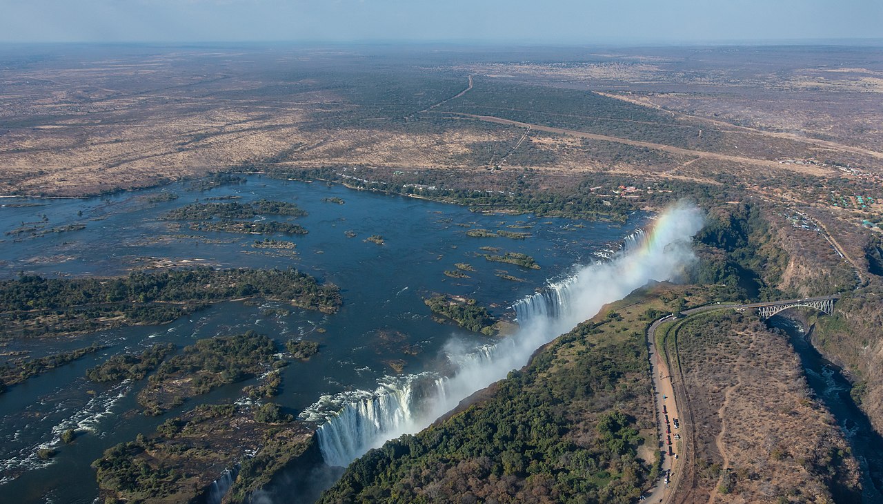
In the Zambezi basin, there are rivers flowing wholly or partially through Zambia: the Kabompo, Lungwebungu, Kafue, Luangwa, and the Zambezi, which flows through the country in the west and then forms its southern border with Namibia, Botswana, and Zimbabwe. Its source is in Zambia and it diverts into Angola, and a number of its tributaries rise in Angola's central highlands. The edge of the Cuando River floodplain (not its main channel) forms Zambia's southwestern border, and via the Chobe River.
Two of the Zambezi's longest and largest tributaries, the Kafue and the Luangwa, flow mainly in Zambia. Their confluences with the Zambezi are on the border with Zimbabwe at Chirundu and Luangwa town respectively. Before its confluence, the Luangwa River forms part of Zambia's border with Mozambique. From Luangwa town, the Zambezi leaves Zambia and flows into Mozambique, and eventually into the Mozambique Channel.
In Eastern Zambia the plateau which extends between the Zambezi and Lake Tanganyika valleys is tilted upwards to the north, and so rises imperceptibly from about 900 metres (3,000 ft) in the south to 1,200 metres (3,900 ft) in the centre, reaching 1,800 metres (5,900 ft) in the north near Mbala. These plateau areas of northern Zambia have been categorised by the World Wildlife Fund as a large section of the Central Zambezian miombo woodlands ecoregion.

The Luangwa Valley splits the plateau in a curve north-east to south-west, extended west into the heart of the plateau by the deep valley of the Lunsemfwa River. Hills and mountains are found by the side of some sections of the valley, including in its north-east the Nyika Plateau (2,200 metres or 7,200 feet) on the Malawi border, which extend into Zambia as the Mafinga Hills, containing the country's highest point, Mafinga Central (2,339 metres or 7,674 feet).
Climate
Zambia is located on the plateau of Central Africa, between 1,000 and 1,600 metres (3,300 and 5,200 ft) above sea level. The average elevation of 1,200 metres (3,900 ft) gives the land a generally moderate climate. The climate of Zambia is tropical, modified by elevation. In the Köppen climate classification, most of the country is classified as humid subtropical (Cfa) or tropical wet and dry (Aw), with stretches of semi-arid steppe climate (BSh) in the south-west and along the Zambezi valley.
The two main seasons are the rainy season (November to April) corresponding to summer, and the dry season (May/June to October/November), corresponding to winter. The dry season is subdivided into the cool dry season (May/June to August), and the hot dry season (September to October/November). The modifying influence of altitude gives the country subtropical weather rather than tropical conditions during the cool season of May to August.
Biodiversity
In 2015, Zambia was reported to have approximately 12,505 identified species: 63% animal species, 33% plant species and 4% bacterial species and other microorganisms.
There are an estimated 3,543 species of wild flowering plants, consisting of sedges, herbaceous plants and woody plants. The Northern and North-Western provinces of the country have the highest diversity of flowering plants. Approximately 53% of flowering plants are rare and occur throughout the country.
A total of 242 mammal species are found in the country, with most occupying the woodland and grassland ecosystems. The Rhodesian giraffe and Kafue lechwe are some subspecies that are endemic to Zambia.
Roughly 490 known fish species, belonging to 24 fish families, have been reported in Zambia, with Lake Tanganyika having the highest number of endemic species.
History
Prehistory
The fossil skull remains of the Broken Hill Man (also known as Kabwe Man), dated between 300,000 and 125,000 years BC, further shows that the area was inhabited by early humans. Broken Hill Man was discovered in Zambia in Kabwe District.
Khoisan and Batwa
Zambia once was inhabited by the Khoisan and Batwa peoples until around AD 300, when migrating Bantu began to settle the areas. It is believed the Khoisan people originated in East Africa and spread southwards around 150,000 years ago. The Twa people were split into two groups: the Kafwe Twa lived around the Kafue Flats and the Lukanga Twa who lived around the Lukanga Swamp. Many examples of ancient rock art in Zambia, like the Mwela Rock Paintings, Mumbwa Caves, and Nachikufu Cave, are attributed to these early hunter-gatherers.

The Bantu (Abantu)
The early history of the peoples of Zambia is deduced from oral records, archaeology, and written records, mostly from non-Africans.
Bantu origins
The Bantu people originally lived in West and Central Africa around what is today Cameroon and Nigeria. Approximately 5000 years ago, they began a millennia-long expansion into much of the continent. This event has been called the Bantu expansion; it was one of the largest human migrations in history. The Bantu are believed to have been the first to have brought iron working technology into large parts of Africa. The Bantu Expansion happened primarily through two routes: a western one via the Congo Basin and an eastern one via the African Great Lakes.
First Bantu settlement
The first Bantu people lived in villages. They lacked an organised unit under a chief or headman and worked as a community and helped each other in times of field preparation for their crops. Villages moved around as the soil became exhausted as a result of the slash-and-burn technique of planting crops. The people kept herds of cattle.
The first Bantu communities in Zambia were highly self-sufficient. Early European missionaries who settled in Southern Zambia noted the independence of these Bantu societies. One of these missionaries noted:
"[If] weapons for war, hunting, and domestic purposes are needed, the [Tonga] man goes to the hills and digs until he finds the iron ore. He smelts it and with the iron thus obtained makes axes, hoes, and other useful implements. He burns wood and makes charcoal for his forge. His bellows are made from the skins of animals and the pipes are clay tile, and the anvil and hammers are also pieces of the iron he has obtained. He moulds, welds, shapes, and performs all the work of the ordinary blacksmith".
Goods traded at the major trading hub of Ingombe Ilede included fabrics, beads, gold, and bangles. The site itself is located at the confluence of the Zambezi and Lusitu rivers, making it ideal for long-distance trade. Denizens imported items from what is today southern Democratic Republic of Congo and Kilwa Kisiwani while others came from as far away as India, China and the Arab world. The African traders were later joined by the Portuguese in the 16th century.
Second Bantu settlement
The second mass settlement of Bantu people into Zambia was of people groups that are believed to have taken the western route of the Bantu migration through the Congo Basin. These Bantu people spent the majority of their existence in what is later the Democratic Republic of Congo.
Luba-Lunda states
The Bemba, along with other related groups such as the Lamba, Bisa, Senga, Kaonde, Swaka, Nkoya and Soli, formed integral parts of the Luba Kingdom in Upemba part of the Democratic Republic of Congo and have a strong relation to the Luba people. The area which the Luba Kingdom occupied has been inhabited by early farmers and iron workers since the 300s C.E.
Over time, these communities learned to use nets and harpoons, make dugout canoes, clear canals through swamps and make dams as high as 2.5 meters (8 ft 2 in). As a result, they grew a diverse economy trading fish, copper and iron items and salt for goods from other parts of Africa, like the Swahili coast and, later on, the Portuguese. From these communities arose the Luba Kingdom in the 14th century.
The Luba Kingdom was a large kingdom with a centralised government and smaller independent chiefdoms. It had large trading networks that linked the forests in the Congo Basin and the mineral-rich plateaus of what is today Copperbelt Province and stretched from the Atlantic coast to the Indian Ocean coast. The arts were also held in high esteem in the kingdom, and artisans were held in high regard.
Literature was well developed in the Luba Kingdom. One renowned Luba genesis story that articulated the distinction between two types of Luba emperors goes as follows:
Nkongolo Mwamba, the red king, and Ilunga Mbidi Kiluwe, a prince of legendary black complexion. Nkongolo Mwamba is the drunken and cruel despot, Ilunga Mbidi Kiluwe the refined and gentle prince. Nkongolo the Red is a man without manners, a man who eats in public, gets drunk, and cannot control himself, whereas [Ilunga] Mbidi Kiluwe is a man of reservation, obsessed with good manners; he does not eat in public, controls his language and his behaviour, and keeps a distance from the vices and modus vivendi of ordinary people. Nkongolo Mwamba symbolises the embodiment of tyranny, whereas Mbidi Kiluwe remains the admired caring and compassionate kin.
In the same region of Southern Congo, the Lunda people were made into a satellite of the Luba empire and adopted forms of Luba culture and governance, thus becoming the Lunda Empire to the south. According to Lunda genesis myths, a Luba hunter named Chibinda Ilunga, son of Ilunga Mbidi Kiluwe, introduced the Luba model of statecraft to the Lunda sometime around 1600 when he married a local Lunda princess named Lueji and was granted control of her kingdom. Most rulers who claimed descent from Luba ancestors were integrated into the Luba empire. The Lunda kings, however, remained separate and actively expanded their political and economic dominance over the region.
The Lunda, like its parent state Luba, also traded with both coasts, the Atlantic and Indian Oceans. While ruler Mwaant Yaav Naweej had established trade routes to the Atlantic coast and initiated direct contact with European traders eager for slaves and forest products and controlling the regional Copper trade, and settlements around Lake Mweru regulated commerce with the East African coast.
The Luba-Lunda states eventually declined as a result of both Atlantic slave trade in the west and Indian Ocean slave trade in the east and wars with breakaway factions of the kingdoms. The Chokwe, a group that is closely related to the Luvale and formed a Lunda satellite state, initially suffered from the European demand for slaves, but once they broke away from the Lunda state, they themselves became notorious slave traders, exporting slaves to both coasts.
The Chokwe eventually were defeated by the other ethnic groups and the Portuguese. This instability caused the collapse of the Luba-Lunda states and a dispersal of people into various parts of Zambia from the Democratic Republic of the Congo. The majority of Zambians trace their ancestry to the Luba-Lunda and surrounding Central African states.
The Maravi Confederacy
In the 1200s, before the founding of the Luba-Lunda states, a group of Bantu people started migrating from the Congo Basin to Lake Mweru then finally settled around Lake Malawi. These migrants are believed to have been one of the inhabitants around the Upemba area in the Democratic Republic of Congo. By the 1400s these groups of migrants collectively called the Maravi, and most prominently among them was the Chewa people who started imitating other Bantu groups like the Tumbuka.
In 1480 the Maravi Empire was founded by the kalonga (paramount chief of the Maravi) from the Phiri clan, one of the main clans, with the others being Banda, Mwale and Nkhoma. The Maravi Empire stretched from the Indian Ocean through what today is Mozambique to Zambia and central parts of Malawi. The political organisation of the Maravi resembled that of the Luba and is believed to have originated from there. The primary export of the Maravi was ivory, which was transported to Swahili brokers.
Iron was also manufactured and exported. In the 1590s the Portuguese endeavoured to take monopoly over Maravi export trade. This attempt was met with outrage by the Maravi of Lundu, who unleashed their WaZimba armed force. The WaZimba sacked the Portuguese trade towns of Tete, Sena and various other towns.
The Maravi are also believed to have brought the traditions that would become Nyau secret society from Upemba. The Nyau form the cosmology or indigenous religion of the people of Maravi. The Nyau society consists of ritual dance performances and masks used for the dances; this belief system spread around the region.
The Maravi declined as a result of succession disputes within the confederacy, attack by the Ngoni and slave raids from the Yao.
Mutapa Empire and Mfecane
As Great Zimbabwe was in decline, one of its princes, Nyatsimba Mutota, broke away from the state forming a new empire called Mutapa. The title of Mwene Mutapa, meaning "Ravager of the Lands", was bestowed on him and subsequent rulers.
The Mutapa Empire ruled territory between the Zambezi and Limpopo rivers, in what is now Zambia, Zimbabwe and Mozambique, from the 14th to the 17th century. By its peak, Mutapa had conquered the Dande area of the Tonga and Tavara. The Mutapa Empire predominately engaged in the Indian Ocean transcontinental trade with and via the WaSwahili. The primary exports were gold and ivory for silk and ceramics from Asia.
Like their contemporaries in Maravi, Mutapa had problems with the arriving Portuguese traders. The peak of this uneasy relationship was reached when the Portuguese attempted to influence the kingdoms internal affairs by establishing markets in the kingdom and converting the population to Christianity. This action caused outrage by the Muslim WaSwahili living in the capital, this chaos gave the Portuguese the excuse they were searching for to warrant an attack on the kingdom and try to control its gold mines and ivory routes. This attack failed when the Portuguese succumbed to disease along the Zambezi river.
In the 1600s internal disputes and civil war began the decline of Mutapa. The weakened kingdom was finally conquered by the Portuguese and was eventually taken over by rival Shona states.
The Portuguese also had vast estates, known as Prazos, and they used slaves and ex-slaves as security guards and hunters. They trained the men in military tactics and gave them guns. These men became expert elephant hunters and were known as the Chikunda. After the decline of the Portuguese the Chikunda made their way to Zambia.
The Portuguese presence in the region was a reason for the founding of the Rozvi Empire, a breakaway state of Mutapa. The ruler of the Rozvi, Changamire Dombo, became one of the most powerful leaders in South-Central Africa's history. Under his leadership, the Rozvi defeated the Portuguese and expelled them from their trading posts along the Zambezi river.
But perhaps the most notable instance of this increased militarisation was the rise of the Zulu under the leadership of Shaka. Pressures from the English colonialists in the Cape and increased militarisation of the Zulu resulted in the Mfecane (the crushing). The Zulu expanded by assimilating the women and children of tribes they defeated, if the men of these Nguni tribes escaped slaughter, they used the military tactics of the Zulu to attack other groups.