
The Tibetan Plateau, also known as the Qinghai–Tibet Plateau, Qingzang Plateau, or Himalayan Plateau, is a vast elevated plateau located at the intersection of Central, South, and East Asia. Geographically, Tibet is located to the north of the Himalayas and the Indian subcontinent, and to the south of Tarim Basin and Mongolian Plateau. Geopolitically, it covers most of the Tibet Autonomous Region, most of Qinghai, the western half of Sichuan, Southern Gansu provinces, southern Xinjiang province in Western China, Bhutan, the Indian regions of Ladakh and Lahaul and Spiti (Himachal Pradesh) as well as Gilgit-Baltistan in Pakistan, northwestern Nepal, eastern Tajikistan and southern Kyrgyzstan.
It stretches approximately 1,000 kilometres (620 mi) north to south and 2,500 kilometres (1,600 mi) east to west. It is the world's largest and highest plateau above sea level, with an area of 2,500,000 square kilometres (970,000 sq mi). With an average elevation exceeding 4,500 metres (14,800 ft) and being surrounded by imposing mountain ranges that harbor the world's two highest summits, Mount Everest and K2, the Tibetan Plateau is often referred to as "the Roof of the World".
The plateau contains the headwaters of most of the streams in surrounding regions. This includes the three longest rivers in Asia (the Yellow, Yangtze, and Mekong). Its tens of thousands of glaciers and other geographical and ecological features serve as a natural "water tower" storing water and maintaining flow. It is sometimes termed the Third Pole because its ice fields contain the largest reserve of fresh water outside the polar regions. The impact of climate change on the Tibetan Plateau is of ongoing scientific interest.

Description
The Tibetan Plateau is surrounded by the massive mountain ranges of high-mountain Asia. The plateau is bordered to the south by the inner Himalayan range, to the north by the Kunlun Mountains which separate it from the Tarim Basin, and to the northeast by the Qilian Mountains, which separate it from the Hexi Corridor and Gobi Desert. To the east and southeast are the Salween, Mekong, and Yangtze rivers in northwest Yunnan, western Sichuan, and southwest Qinghai. In the west, the curve of the rugged Karakoram range of northern Kashmir embraces the plateau. The Indus River originates in the western Tibetan Plateau in the vicinity of Lake Manasarovar.
The plateau is bounded in the north by a broad escarpment where the altitude drops from around 5,000 metres (16,000 ft) to 1,500 metres (4,900 ft) over a horizontal distance of less than 150 kilometres (93 mi). Along the escarpment is a range of mountains. About halfway across the Tarim Basin the bounding range becomes the Altyn-Tagh, and the Kunluns, by convention, continue somewhat to the south. In the 'V' formed by this split is the western part of the Qaidam Basin. The Altyn-Tagh ends near the Dangjin pass on the Dunhuang–Golmud road. To the west are short ranges called the Danghe, Yema, Shule, and Tulai Nanshans. The easternmost range is the Qilian Mountains. The line of mountains continues east of the plateau as the Qinling, which separates the Ordos Plateau from Sichuan. North of the mountains runs the Gansu or Hexi Corridor which was the main silk-road route from China proper to the west.
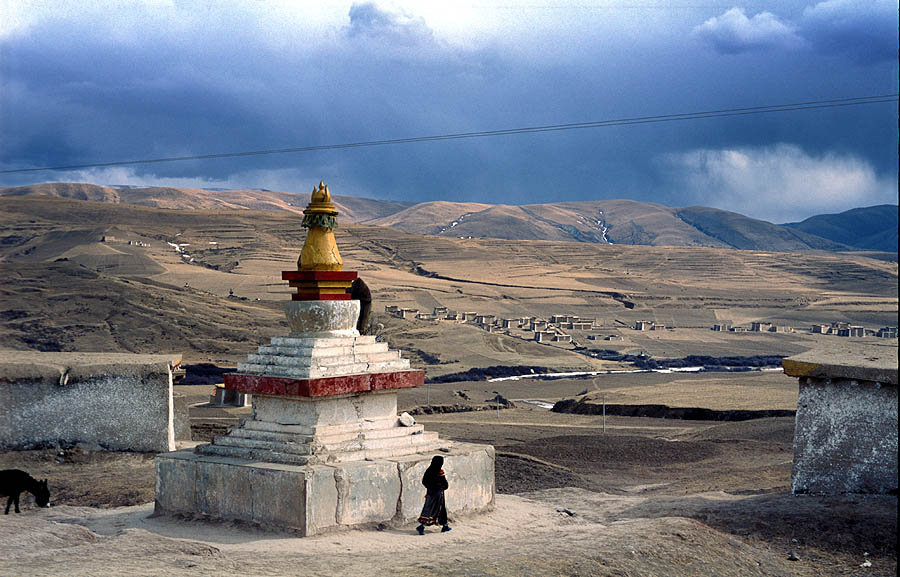
The plateau is a high-altitude arid steppe interspersed with mountain ranges and large brackish lakes. Annual precipitation ranges from 100 to 300 millimetres (3.9 to 11.8 in) and falls mainly as hail. The southern and eastern edges of the steppe have grasslands that can sustainably support populations of nomadic herdsmen, although frost occurs for six months of the year. Permafrost occurs over extensive parts of the plateau. Proceeding to the north and northwest, the plateau becomes progressively higher, colder, and drier, until reaching the remote Changtang region in the northwestern part of the plateau. Here the average altitude exceeds 5,000 metres (16,000 ft) and winter temperatures can drop to −40 °C (−40 °F). As a result of this extremely inhospitable environment, the Changtang region (together with the adjoining Kekexili region) is the least populous region in Asia and the third least populous area in the world after Antarctica and northern Greenland.
Geology and geological history
The geological history of the Tibetan Plateau is closely related to that of the Himalayas. The Himalayas belong to the Alpine orogeny and are among the younger mountain ranges on the planet, consisting mostly of uplifted sedimentary and metamorphic rock. Their formation is a result of a continental collision or orogeny along the convergent boundary between the Indo-Australian plate and the Eurasian plate.
The collision began in the Upper Cretaceous period about 70 million years ago (Mya), when the north-moving Indo-Australian plate, moving at about 15 cm (6 in) per year, collided with the Eurasian plate. About 50 Mya, the fast-moving Indo-Australian plate had completely closed the Tethys Ocean, the existence of which has been determined by sedimentary rocks settled on the ocean floor and the volcanoes that fringed its edges. Since these sediments were light, they crumpled into mountain ranges rather than sinking to the floor. During this early stage of its formation in the Late Palaeogene, Tibet consisted of a deep valley bounded by multiple mountain ranges rather than the more topographically uniform elevated flatland that it is today. The Tibetan Plateau's mean elevation continued to vary since its initial uplift in the Eocene; isotopic records show the plateau's altitude was around 3,000 metres above sea level around the Oligocene–Miocene boundary and that it fell by 900 metres between 25.5 and 21.6 Mya, attributable to tectonic unroofing from east–west extension or to erosion fromweathering. The plateau subsequently rose by 500 to 1,000 metres between 21.6 and 20.4 million years ago.
Palaeobotanical evidence indicates that the Nujiang Suture Zone and the Yarlung-Tsangpo Suture Zone remained tropical or subtropical lowlands until the late Oligocene or Early Miocene, enabling biotic interchange across Tibet. The age of east–west grabens in the Lhasa and Himalaya terranes suggests that the plateau's elevation was close to its modern altitude by around 14 to 8 Mya. Erosion rates in Tibet decreased significantly around 10 Mya. The Indo-Australian plate continues to be driven horizontally below the Tibetan Plateau, which forces the plateau to move upwards; the plateau is still rising at a rate of approximately 5 mm (0.2 in) per year (although erosion reduces the actual increase in height).

Much of the plateau is of relatively low relief. The cause of this is debated among geologists. Some argue that the plateau is an uplifted peneplain formed at low altitude, while others argue that the low relief stems from erosion and infill of topographic depressions that occurred at already high elevations. The current tectonics of the plateau are also debated. The best-regarded explanations are provided by the block model and the alternative continuum model. According to the former, the crust of the plateau is formed of several blocks with little internal deformation separated by major strike-slip faults. In the latter, the plateau is affected by distributed deformation resulting from flow within the crust.
Environment
The Tibetan Plateau supports a variety of ecosystems, most of them classified as montane grasslands. While parts of the plateau feature an alpine tundra-like environment, other areas feature monsoon-influenced shrublands and forests. Species diversity is generally reduced on the plateau due to the elevation and low precipitation. The plateau hosts the Tibetan wolf, and species of snow leopard, wild yak, wild ass, cranes, vultures, hawks, geese, snakes, and water buffalo. One notable animal is the high-altitude jumping spider that can live at elevations of over 6,500 metres (21,300 ft).
Ecoregions, as defined by the World Wide Fund for Nature, are as follows:

The Pamir alpine desert and tundra covers the western end where it transitions to the Pamir Mountains
The North Tibetan Plateau–Kunlun Mountains alpine desert covers the northwestern limits along the Kunlun Mountains
The Karakoram–West Tibetan Plateau alpine steppe covers the westernmost parts and Ladakh

The Northwestern Himalayan alpine shrub and meadows on the edges mountains bordering the extreme west
The Central Tibetan Plateau alpine steppe covers most of the central portions and the eastern Changtang
The Western Himalayan alpine shrub and meadows covers the southwestern plateau in the Garuda Valley region
The Qaidam Basin semi-desert located in the Qaidam Basin in the north
The Qilian Mountains subalpine meadows covering the Qilian Mountains in the northernmost portions
The Qilian Mountains conifer forests covering parts of the mountain ranges in the northeast
The Tibetan Plateau alpine shrublands and meadows covering a swath of the central and northeast
The Yarlung Tsangpo arid steppe in the Yarlung Tsangpo river Valley, where most of the permanent human population lives
The Eastern Himalayan alpine shrub and meadows cover the south on the northern side of the Himalayas
The Southeast Tibet shrub and meadows cover the southeastern and eastern parts of the plateau and are generally rainier than the other high-altitude regions
The Northeastern Himalayan subalpine conifer forests reach up mountain valleys in the south and contain some of the highest altitude forests in the world
The Nujiang Lancang Gorge alpine conifer and mixed forests cover the mountain valleys that reach 500 km (310 mi) into the southeast
The Hengduan Mountains subalpine conifer forests cover the southeasternmost mountain valleys
The Qionglai–Minshan conifer forests cover the eastern edges
Human history
Archaic Denisovans lived on the plateau from around 200,000 to 40,000 years ago, according to a study published in Nature. Archaeological evidence suggests that the earliest human occupation of the plateau occurred between 30,000 and 40,000 years ago.
Since colonization of the plateau, Tibetan culture has adapted and flourished in the western, southern, and eastern regions. The Changtang is generally too high and cold to support permanent population. The Tibetan Empire existed from the 7th century to the 9th century AD. Nomads are the remainders of nomadic practices historically once widespread in Asia and Africa. Pastoral nomads constitute about 40% of the ethnic Tibetan population. The presence of nomadic peoples on the plateau is predicated on their adaptation to survival on the world's grassland by raising livestock rather than crops, which are unsuitable to the terrain.
Impact on other regions
Monsoons are caused by the different amplitudes of surface temperature seasonal cycles between land and oceans. This differential warming occurs because heating rates differ between land and water. Ocean heating is distributed vertically through a "mixed layer" that may be 50 meters deep through the action of wind and buoyancy-generated turbulence, whereas the land surface conducts heat slowly, with the seasonal signal penetrating only a meter or so. Additionally, the specific heat capacity of liquid water is significantly greater than that of most materials that make up land.
Together, these factors mean that the heat capacity of the layer participating in the seasonal cycle is much larger over the oceans than over land, with the consequence that the land warms and cools faster than the ocean. In turn, air over the land warms faster and reaches a higher temperature than does air over the ocean. The warmer air over land tends to rise, creating an area of low pressure. The pressure anomaly then causes a steady wind to blow toward the land, which brings the moist air over the ocean surface with it. Rainfall is then increased by the presence of the moist ocean air. The rainfall is stimulated by a variety of mechanisms, such as low-level air being lifted upwards by mountains, surface heating, convergence at the surface, divergence aloft, or from storm-produced outflows near the surface. When such lifting occurs, the air cools due to expansion in lower pressure, which in turn produces condensation and precipitation.
In winter, the land cools off quickly, but the ocean maintains the heat longer. The hot air over the ocean rises, creating a low-pressure area and a breeze from land to ocean while a large area of drying high pressure is formed over the land, increased by wintertime cooling. Monsoons are similar to sea and land breezes, a term usually referring to the localized, diurnal cycle of circulation near coastlines everywhere, but they are much larger in scale, stronger and seasonal. The seasonal monsoon wind shift and weather associated with the heating and cooling of the Tibetan Plateau is the strongest such monsoon on Earth.
Glaciers
Frozen biological samples
Ice of the plateau provides a valuable window to the past. In 2015, researchers studying the plateau reached the top of the Guliya glacier, with ice thickness of 310 m (1,020 ft), and drilled to a depth of 50 m (160 ft) in order to recover ice core samples. Due to the extremely low biomass in those 15,000-year-old samples, it had taken around 5 years of research to extract 33 viruses, of which 28 were new to science. None had survived the extraction process. Phylogenetic analysis suggests those viruses had infected plants or other microorganisms.
Climate change
The Tibetan Plateau contains the world's third-largest store of ice. Qin Dahe, the former head of the China Meteorological Administration, issued the following assessment in 2009:
Temperatures are rising four times faster than elsewhere in China, and the Tibetan glaciers are retreating at a higher speed than in any other part of the world. In the short term, this will cause lakes to expand and bring floods and mudflows. In the long run, the glaciers are vital lifelines for Asian rivers, including the Indus and the Ganges. Once they vanish, water supplies in those regions will be in peril.The Tibetan Plateau contains the largest area of low-latitude glaciers and is particularly vulnerable to global warming. Over the past five decades, 80% of the glaciers have retreated, losing 4.5% of their combined areal coverage. The region is also liable to suffer damages from permafrost thaw caused by climate change.