
Stanley Park is a 405-hectare (1,001-acre) public park in British Columbia, Canada, that makes up the northwestern half of Vancouver's Downtown peninsula, surrounded by waters of Burrard Inlet and English Bay The park borders the neighbourhoods of West End and Coal Harbour to its southeast, and is connected to the North Shore via the Lions Gate Bridge. The historic lighthouse on Brockton Point marks the park's easternmost point. While it is not the largest urban park, Stanley Park is about one-fifth larger than New York City's 340-hectare (840-acre) Central Park and almost half the size of London's 960-hectare (2,360-acre) Richmond Park.
Stanley Park has a long history. The land was originally used by Indigenous peoples for thousands of years before British Columbia was colonized by the British during the 1858 Fraser Canyon Gold Rush and was one of the first areas to be explored in the city. For many years after colonization, the future park, with its abundant resources, would also be home to non-Indigenous settlers. The land was later turned into Vancouver's first park when the city incorporated in 1886. It was named after Lord Stanley 16th Earl of Derby, a British politician who had recently been appointed Governor General of Canada. It was originally known as Coal Peninsula and was set aside for military fortifications to guard the entrance to Vancouver harbour. In 1886, Vancouver City Council successfully sought a lease of the park which was granted for $1 per year. In September 1888, Lord Stanley opened the park in his name.
Unlike other large urban parks, Stanley Park is not the creation of a landscape architect but rather the evolution of a forest and urban space over many years. Most of the manmade structures present in the park were built between 1911 and 1938 under the influence of then-superintendent W.S. Rawlings. Additional attractions, such as a polar bear exhibit, aquarium, and a miniature train, were added in the post–World War II period.

Much of the park remains as densely forested as it was in the late 1800s, with about a half million trees, some of which stand as tall as 76 metres (249 ft) and are hundreds of years old. Thousands of trees were lost (and many replanted) after three major windstorms that took place in the past 100 years, the last in 2006.
Significant effort was put into constructing the near-century-old Vancouver Seawall, which can draw thousands of people to the park in the summer. The park also features forest trails, beaches, lakes, children's play areas, and the Vancouver Aquarium, among many other attractions. On June 18, 2014, Stanley Park was named "top park in the entire world" by Tripadvisor, based on reviews submitted.
History
Coast Salish land
Archaeological evidence suggests a human presence in the park dating back more than 3,000 years. The area is the traditional territory of multiple coastal Indigenous peoples. From the Burrard Inlet and Howe Sound regions, Squamish Nation had a large village in the park. From the lower Fraser River area, Musqueam Nation used its natural resources.

Where Lumberman's Arch is now, there once was a large village called Whoi Whoi, or X̱wáýx̱way, roughly meaning 'place of masks'. One longhouse, built from cedar poles and slabs, was measured at 61 metres (200 ft) long by 18 metres (60 ft) wide. These houses were occupied by large extended families living in different quadrants of the house. The larger houses were used for ceremonial potlatches where a host would invite guests to witness and participate in ceremonies and the giving away of property.
Another settlement was further west along the same shore. This place was called Chaythoos, meaning 'high bank'. The site of Chaythoos is noted on a brass plaque placed on the lowlands east of Prospect Point commemorating the park's centennial.
Both sites were occupied in 1888, when some residents were forcefully removed to allow a road to be constructed around the park, and their midden was used for construction material.

The popular landmark Siwash Rock, located near present-day Third Beach, was once called Slhx̱i7lsh, meaning 'he is standing up'. In the oral history, a fisherman was transformed into this rock by three powerful brothers as punishment for his immorality.
In 2010, the chief of the Squamish Nation proposed renaming Stanley Park as Xwayxway Park after the large village once located in the area.
European exploration
The first European explorations of the peninsula were made by expeditions commanded by Spanish captain José María Narváez (1791) and British captain George Vancouver (1792).
In A Voyage of Discovery, Vancouver describes the area as "an island ... with a smaller island Deadman's Island (the correct name being Deadman Island) lying before it", suggesting that it was originally surrounded by water, at least at high tide.
Vancouver also wrote about meeting the people living there:Here we were met by about fifty [natives] in canoes, who conducted themselves with great decorum and civility, presenting us with several fish cooked and undressed of a sort resembling smelt. These good people, finding we were inclined to make some return for their hospitality, showed much understanding in preferring iron to copper.
According to historians, the Indigenous peoples probably first saw Vancouver's ship from Chaythoos, a location in the future park that in today's terms lay just east of the Lions Gate Bridge (or First Narrows Bridge as it is sometimes called). Speaking about this event later in a conversation with archivist Major Matthews, Andy Paull, whose family lived in the area, confirms the account given by Vancouver:

As Vancouver came through the First Narrows, the [natives] in their canoes threw these feathers in great handfuls before him. They would of course rise in the air, drift along, and fall to the surface of the water, where they would rest for quite a time. It must have been a pretty scene, and duly impressed Captain Vancouver, for he speaks most highly of the reception he was accorded.
No significant contact with inhabitants in the area was recorded for decades, until around the time of the Crimean War (1853–1856). British admirals arranged with Chief Joe Capilano that if there were an invasion, the British would defend the south shore of Burrard Inlet and the Squamish would defend the north. The British gave him and his men 60 muskets. Although the attack anticipated by the British never came, the guns were used by the Squamish to repel an attack by an indigenous raid from the Euclataws. Stanley Park was not attacked, but this was when it started to be thought of as a strategic military position.
Early uses of park land
The peninsula was a popular place for gathering traditional food and materials in the 1800s, but it started to see even more activity after the Fraser Canyon Gold Rush in 1858, going through a succession of uses when non-Indigenous settlers moved into the area.

The shallow waters around the First Narrows and Coal Harbour were popular fishing spots for clams, salmon, and other fish. August Jack Khatsahlano, a celebrated dual chief of the Squamish and Musqueam who once lived at Chaythoos, remembered how he used to fish-rake in Coal Harbour and catch many herrings. They would also hunt grouse, ducks, and deer on the peninsula.
Second Beach was a source of "clay ... which, when rolled into loaves, as (my people) did it, and heated or roasted before a fire, turned into a white like chalk" that was used to make wool blankets.
Indigenous inhabitants also cut down large cedar trees in the area for a variety of traditional purposes, such as making dugout canoes.
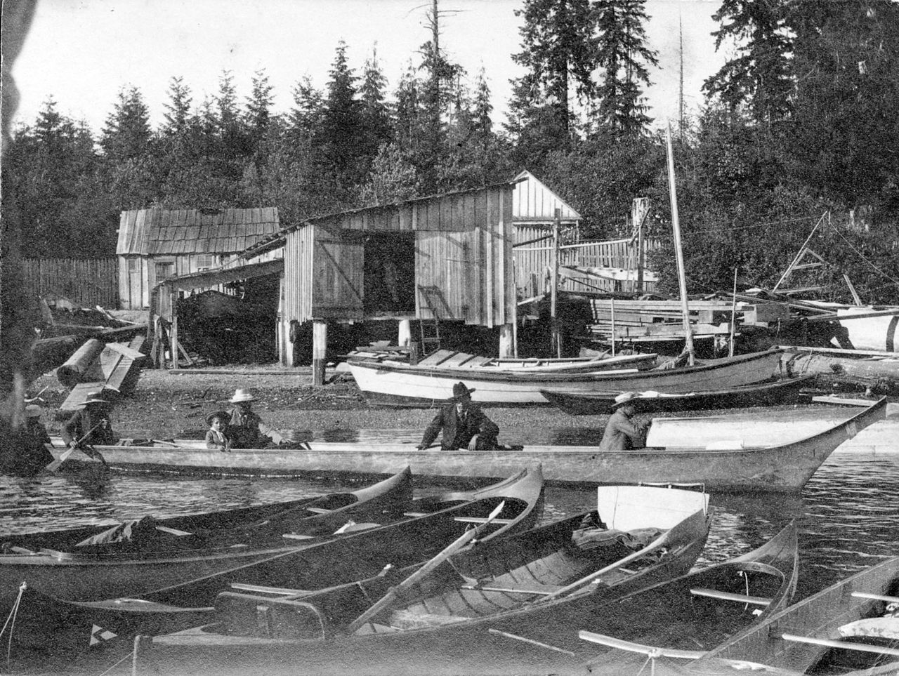
By 1860, non-Indigenous settlers (Portuguese, Scots, and others) had started building homes on the peninsula, first at Brockton Point and later on Deadman Island. "Portuguese Joe" Silvey was the first European to settle in the future park. A Chinese settlement also grew in a cleared area at Anderson Point (near the present day Vancouver Rowing Club).
The peninsula was surveyed and made a military reserve in an 1863 survey completed by the Royal Engineers. Despite the houses and cabins on the land, it was again considered a strategic point in case Americans attempted an invasion and launched an attack on New Westminster (then the colonial capital) via Burrard Inlet.
In 1865, Edward Stamp decided that Brockton Point would be an ideal site for a lumber mill. He cleared close to 40 hectares (100 acres) with the permission of colonial officials, but the site proved too impractical and he moved his operation east, eventually becoming Hastings Mill. The land cleared by Stamp later became the Brockton sports fields.
The future park was selectively logged by six different companies between the 1860s and 1880s, but its military status saved the land from further development. Most of today's trails in Stanley Park got their start as old skid roads.
Near the end of the 1800s, the city's principal reservoir was built in the area south of Prospect Point that is now a playing field and picnic area. Despite the reservoir's demolition in 1948, there is still a Reservoir Trail at that location.
From the 1860s to 1880s, settlers in Burrard Inlet used Brockton Point, Anderson Point, and nearby Deadman Island as burial grounds. This practice stopped when the Mountain View Cemetery opened in 1887. Deadman Island had already had a long history as a burial site. In 1865, unsuspecting newcomer John Morton found old cedar boxes in the trees. They turned out to be coffins that had been placed there to keep the remains of important Indigenous persons out of reach of wild animals.
Leasing the land
In 1886, as its first order of business, Vancouver City Council voted to petition the British government to lease the military reserve for use as a park. To manage their new acquisition, city council appointed a six-person park committee, which in 1890 was replaced with an elected body, the Vancouver Park Board.
In 1908, 20 years after the first lease, the federal government renewed the lease for 99 more years.
In 2006, a letter from Parks Canada stated that "the Stanley Park lease is perpetually renewable and no action is required by the Park Board in relation to the renewal".
Opening and dedication
On September 27, 1888, the park was officially opened (although the legal status of Deadman Island as part of the park would remain ambiguous for many years). The park was named after Lord Stanley, who had recently become Canada's sixth governor general. Mayor David Oppenheimer gave a formal speech opening the park to the public and delivering authority for its management to the park committee.
The following year, Lord Stanley became the first governor general to visit Vancouver when he officially dedicated the park. Mayor Oppenheimer led a procession of vehicles around Brockton Point along the newly completed Park Road to the clearing at Prospect Point. An observer at the event wrote:
Lord Stanley threw his arms to the heavens, as though embracing within them the whole of 1000 acres of primeval forest, and dedicated it "to the use and enjoyment of peoples of all colours, creeds, and customs, for all time. I name thee Stanley Park."
Eviction of pre-park residents
When Lord Stanley made his declaration, there were still a number of homes on lands he had claimed for the park. Some, who had built their homes less than twenty years earlier, would continue to live on the land for years. Most were evicted by the park board in 1931, but the last resident, Tim Cummings, lived at Brockton Point until his death in 1958.
Sarah Avison, the daughter of the first park ranger, recalled when the city evicted the Chinese settlers at Anderson Point in 1889:
The Park Board ordered the [Chinese settlers] to leave the park; they were trespassers; but [they] would not go, so the Park Board told my father to set fire to the buildings. I saw them burn; there were five of us children, and you know what children are like when there is a fire. So father set fire to the shacks; what happened to the Chinese I do not know.
Most of the dwellings at Xwayxway were reported vacant by 1899, and in 1900, two of such houses were purchased by the park board for $25 each and burned. One Squamish family, "Howe Sound Jack" and Sexwalia "Aunt Sally" Kulkalem, continued to live at Xwayxway until Sally died in 1923. Sally's ownership of the property surrounding her home was accepted by authorities in the 1920s, and following her death, the property was purchased from her heir, Mariah Kulkalem, for $15,500 and resold to the federal government.
Although most residents of the area were evicted by the early 20th century, the municipal government still owns a number of field homes used by the park's "live-in caretakers". Caretakers that occupy the field homes are not charged rent by the city, although they are required to assist in park operations and provide a permanent presence for the park board. In 2006, the City of Vancouver decided it would no longer replace live-in caretakers who retired or moved out from the field homes, with the city opting to convert several unoccupied field homes into artist studios.
Construction of Lost Lagoon and causeway
From 1913 to 1916, a lake was constructed in a shallow part of Coal Harbour, a project that was not without its detractors. The lake was named Lost Lagoon due to its history of "disappearing" at low tide. The lake and a causeway into the park were designed by Thomas Mawson, who also designed a lighthouse for Brockton Point around the same time. Before the causeway, a wooden footbridge provided the only access route into the park from Coal Harbour. Construction of the causeway (and new roads within the park for emergency access) was completed by 1926.
In 1923, the saltwater pipes entering the lake from Coal Harbour were shut off, turning it into a freshwater lake. A lit fountain was later erected to commemorate the city's golden jubilee. The fountain, installed in 1936, was purchased from Chicago, a leftover from its world's fair in 1933.
The causeway was widened and extended through the centre of the park in the 1930s with the construction of the Lions Gate Bridge, which connects downtown Vancouver to the North Shore. At the same time, two pedestrian subways were added under the causeway at the entrance to the park from Georgia Street.
By the 1950s, visitors could take rented rowboats on Lost Lagoon, but boating and other activities were banned in 1973 as the lake became a bird sanctuary. By 1995, the old boathouse had been turned into the Lost Lagoon Nature House. It is operated by the Stanley Park Ecology Society, which is a nonprofit organization that works alongside of the Vancouver Park Board to promote stewardship and conservation in Stanley Park.
Seawall
Construction of the 8.8-kilometre (5.5 mi) seawall and walkway around the park began in 1917 and took several decades to complete. The original idea for the seawall is attributed to park board superintendent W. S. Rawlings, who conveyed his vision in 1918: It is not difficult to imagine what the realization of such an undertaking would mean to the attractions of the park and personally I doubt if there exists anywhere on this continent such possibilities of a combined park and marine walk as we have in Stanley Park.
James "Jimmy" Cunningham, a master mason, dedicated 32 years of his life to the construction of the seawall from 1931 until his retirement in 1963. Cunningham continued to return to monitor the wall's progress until his death at 85.
The walkway was extended several times and, as of 2023, is 22 kilometres (14 mi) from end to end, making it the world's longest uninterrupted waterfront walkway. The Stanley Park portion is just under half of the entire length, which starts at Canada Place in the downtown core, runs around Stanley Park, along English Bay, around False Creek, and finally to Kitsilano Beach. From there, a trail continues 600 metres (2,000 ft) to the west, connecting to an additional 12 kilometres (7.5 mi) of beaches and pathways that terminate at the mouth of the Fraser River.
Swimming pools
By 1933, there were two seaside, saltwater pools in the park, one at Second Beach and one at Lumberman's Arch. These "draw and fill" pools used sun-warmed water from the ocean. Once a week, the pool gates were opened at low tide to release the water back into the ocean, before the next high tide of clean water.
For many years, children could take swimming lessons for free at Lumberman's Arch under the Vancouver Sun's Learn to Swim program. The pool was filled in after developing persistent problems and replaced with the current water spray park in 1987. The spray park, the largest of its kind in Vancouver, consists of a series of water geysers, showers, and cannons.
In 1995, after more than 60 years of operation, the Second Beach pool was shut down because it failed to meet new health standards. By 1996, it had been replaced with the current heated pool.
At both locations, remnants of the old pool's semicircle shaped outer wall can still be seen.
In wartime
See List of World War II-era fortifications on the British Columbia Coast