
The Ohio River (Seneca: Ohi:yo') is a 981-mile-long (1,579 km) river in the United States. It is located at the boundary of the Midwestern and Southern United States, flowing in a southwesterly direction from Pittsburgh, Pennsylvania, to its mouth on the Mississippi River at Cairo, Illinois. It is the third largest river by discharge volume in the United States and the largest tributary by volume of the Mississippi River. It is also the sixth oldest river on the North American continent. The river flows through or along the border of six states, and its drainage basin includes parts of 14 states. Through its largest tributary, the Tennessee River, the basin includes several states of the southeastern United States. It is the source of drinking water for five million people.
The river became a primary transportation route for pioneers during the westward expansion of the early U.S. The lower Ohio River just below Louisville was obstructed by rapids known as the Falls of the Ohio where the elevation falls 26 feet (7.9 m) in 2 miles (3.2 km) restricting larger commercial navigation, although in the 18th and early 19th century its three deepest channels could be traversed by a wide variety of craft then in use. In 1830, the Louisville and Portland Canal (now the McAlpine Locks and Dam) bypassed the rapids, allowing even larger commercial and modern navigation from the Forks of the Ohio at Pittsburgh to the Port of New Orleans at the mouth of the Mississippi on the Gulf of Mexico. Since the "canalization" of the river in 1929, the Ohio has not been a natural free-flowing river; today, it is divided into 21 discrete pools or reservoirs by 20 locks and dams for navigation and power generation.
The name "Ohio" comes from the Seneca word Ohi:yo', meaning "good river". In his Notes on the State of Virginia published in 1781–82, Thomas Jefferson stated: "The Ohio is the most beautiful river on earth. Its current gentle, waters clear, and bosom smooth and unbroken by rocks and rapids, a single instance only excepted."
After the French and Indian War, Britain's trans-Appalachian Indian Reserve was divided by the river into colonial lands to the south and Native American lands to the north. In the late 18th century, the river became the southern boundary of the Northwest Territory. The river was in the early 19th century considered the western extension of the Mason–Dixon line that divided Pennsylvania from Maryland, and thus part of the border between free and slave territory, and between the Northern and Southern United States or Upland South. Where the river was narrow, it was crossed by thousands of slaves escaping to the North for freedom; many were helped by free blacks and whites of the Underground Railroad resistance movement.
The Ohio River is a climatic transition area, as its water runs along the periphery of the humid continental and humid subtropical climate areas. It is inhabited by fauna and flora of both climates. During winter, it regularly freezes over in Pittsburgh but rarely farther south towards Cincinnati and Louisville. Further down the river in places like Owensboro and Paducah, closer to its confluence with the Mississippi, the Ohio is ice-free year-round.
Today, the Ohio River is one of the most polluted rivers in the United States. The Ohio has faced significant industrial pollution historically along with farm runoff.

Etymology
The name "Ohio" derives from the Seneca word Ohi:yo' (roughly pronounced oh-HEE-yoh, with the vowel in "hee" held longer), a proper name derived from ohiːyoːh ("good river"). "Great river" and "large creek" have also been given as translations.
Native Americans, including the Lenape and Iroquois, considered the Ohio and Allegheny rivers as the same, as is suggested by a New York State road sign on Interstate 86 that refers to the Allegheny River also as Ohi:yo'. Similarly, the Geographic Names Information System lists O-hee-yo and O-hi-o as variant names for the Allegheny.
An earlier Miami-Illinois language name was also applied to the Ohio River, Mosopeleacipi ("river of the Mosopelea" tribe). Shortened in the Shawnee language to pelewa thiipi, spelewathiipi or peleewa thiipiiki, the name evolved through variant forms such as "Polesipi", "Peleson", "Pele Sipi" and "Pere Sipi", and eventually stabilized to the variant spellings "Pelisipi", "Pelisippi" and "Pellissippi". Originally applied just to the Ohio River, the "Pelisipi" name later was variously applied back and forth between the Ohio River and the Clinch River in Virginia and Tennessee. In his original draft of the Land Ordinance of 1784, Thomas Jefferson proposed a new state called "Pelisipia", to the south of the Ohio River, which would have included parts of present-day Eastern Kentucky, Virginia and West Virginia.
History
Indigenous use
The river had great significance in the history of the Native Americans, as numerous prehistoric and historic civilizations formed along its valley. For thousands of years, Native Americans used the river as a major transportation and trading route.
In the five centuries before European colonization, the Mississippian culture built numerous regional chiefdoms and major earthwork mounds in the Ohio Valley like the Angel Mounds near Evansville, Indiana as well as in the Mississippi Valley and the Southeast. The historic Osage, Omaha, Ponca, and Kaw peoples lived in the Ohio Valley. Under pressure over the fur trade from the Iroquois nations to the northeast, they migrated west of the Mississippi River in the 17th century to the territory now defined as Missouri, Arkansas, and Oklahoma.
European arrival
Several accounts exist of the discovery and traversal of the Ohio River by Europeans in the latter half of the 17th century: Virginian colonist Abraham Wood's trans-Appalachian expeditions between 1654 and 1664; Frenchman Robert de La Salle's putative Ohio expedition of 1669; and two expeditions of Virginians sponsored by Colonel Wood: the Batts and Fallam expedition of 1671, and the Needham and Arthur expedition of 1673–74.

Exploration and settlement
Arnout Viele (1693)
In early autumn 1692, loyal English-speaking Dutchman Arnout Viele and a party of eleven companions from Esopus—Europeans, Shawnee, and a few loyal Delaware guides—were sent by the governor of New York to trade with the Shawnee and bring them into the English sphere of influence. Viele understood several Native American languages, which made him valuable as an interpreter. He is credited with being the first European to travel and explore western Pennsylvania and the upper Ohio Valley. Viele made contact with Native American nations as far west as the Wabash River, in present-day Indiana.
He and his company left Albany, traveling southbound and crossing portions of present-day New Jersey and eastern Pennsylvania. They apparently followed the west branch of the Susquehanna River into the mountains, traversing the Tioga River and reaching a tributary of the Allegheny River before floating down to the Shawnee towns along the Ohio River. Viele and his expedition spent most of 1693 exploring the Ohio River and its tributaries in northern Kentucky with their Shawnee hosts. Gerit Luykasse, two of Viele's Dutch traders, and two Shawnee reappeared in Albany in February 1694 "to fetch powder for Arnout [Viele] and his Company"; their party had been gone for fifteen months, but Viele was away for about two years. He and his companions returned from the Pennsylvania wilderness in August 1694, accompanied by diplomats from "seven Nations of Indians" who sought trade with the English (or peace with the powerful Iroquois nations of New York and Pennsylvania), and hundreds of Shawnee who intended to relocate in the Minisink country on the upper Delaware River.
Gaspard-Joseph Chaussegros de Léry (1729)
In 1729, Gaspard-Joseph Chaussegros de Léry, a French architect and surveyor whose survey was the first mapping of the Ohio River, led an expedition of French troops from Fort Niagara down the Allegheny and Ohio Rivers as far as the mouth of the Great Miami River near Big Bone Lick and possibly the Falls of the Ohio (present-day Louisville). Chaussegros de Léry mapped the Great Lakes in 1725, and engineered the Niagara fortifications in 1726.

I am indebted for the topographical details of the course of this River to M. de Lery, Engineer, who surveyed it with the compass at the time that he descended it with a detachment of French troops in 1729.
A map of the Ohio River valley, drawn by Bellin from observations by de Lery, is in Pierre François Xavier de Charlevoix's History of New France. The 1744 Bellin map, "Map of Louisiana" (French: Carte de La Louisiane), has an inscription at a point south of the Ohio River and north of the Falls: "Place where one found the ivory of Elephant in 1729" (French: endroit ou on à trouvé des os d'Elephant en 1729). De Lery's men found teeth weighing ten pounds (4.5 kg) with a diameter of five to seven inches (130 to 180 mm), tusks 11 feet (3.4 m) long and 6–7 inches (150–180 mm) in diameter, and thigh bones 5 feet (1.5 m) long. The bones were collected and shipped to Paris, where they were identified as mastodon remains; they are on display at the French National Natural History Museum.
Charles III Le Moyne, Baron de Longueil (1739)
Charles III Le Moyne, second Baron de Longueuil (later the governor of Montreal and interim governor of New France), commanded Fort Niagara from 1726 to 1733. He led an expedition of 442 men, including Native Americans, from Montreal to war against the Chickasaw who occupied territory on the lower part of the Mississippi River in the area claimed as La Louisiane. According to Gaston Pierre de Lévis, Duke de Mirepoix, the expedition used the Ohio River as a corridor to the Mississippi.

Among the officers who accompanied this party were Major de Lignery; Lieutenants, de Vassan, Aubert de Gaspe, Du Vivier, de Verrier, Le Gardeur de St. Pierre, Chevalier de Villiers, de Portneuf, de Sabrevious; Father Vernet, chaplain; Cadets, Joncaire de Closonne, Le Gai de Joncaire, Drouet de Richarville the younger, Chaussegros de Lery the younger, de Gannes, Chev. Benoist, de Morville, de Selles, and seventeen others. The rank and file consisted of three sergeants, six corporals, six lance corporals, twenty-four soldiers, forty-five habitants, one hundred and eighty-six Iroquois from the Sault, forty-one from the Lake of Two Mountains, thirty-two Algonquin and Nipissing, fifty Abenaqui from St. Francois and Bécancour, Quebec; Father La Bretonnier, Jesuit; Queret, missionary.
One of the first reported eyewitness accounts of Shannoah, a Shawnee town, was by le Moyne III in July 1739. On their journey down the Ohio River toward the Mississippi, they met with local chiefs in a village on the Scioto River.
John Howard and John Peter Salling (1742)
John Howard, a pioneer from Virginia, led a party of five—John Peter Salling (a Pennsylvania German), Josiah Howard (John's son), Charles Sinclair, and John Poteet (Vizt)—from the Virginia mountains to the Mississippi River. The elder Howard had a promised reward of 10,000 acres (4,000 ha) of land for a successful expedition from the Virginia Royal Governor's Council to reinforce British claims in the west. Howard offered equal shares of the 10,000 acres to the four other members of his expedition. The party of five left John Peter Salling's house in August County on March 16, 1742, and traveled west to Cedar Creek (near the Natural Bridge), crossing Greenbrier River and landing at the New River. At New River, the Virginia explorers built a large bull boat frame and covered it with five buffalo skins. The first Englishmen to explore the region then followed the New River for 250 miles (400 km), until it became too dangerous to navigate. At a large waterfall, they traveled overland to the Coal River. Following the Kanawha River, they entered the Ohio River 444 miles (715 km) above the falls. The Virginia pioneers traced the northern boundary of Kentucky for five hundred miles (800 km), reaching the Mississippi River on June 7. They descended just below the mouth of the Arkansas River, where they were ambushed by a large company of Native Americans, Blacks and Frenchmen on July 2, 1742; one or two of Howard's men were killed. The rest were brought to New Orleans and imprisoned as spies. After two years in prison, Salling escaped on October 25, 1744, and returned on a southern route to his home in Augusta County, Virginia, in May 1745. John Howard was extradited to France to stand trial. His ship was intercepted by the English and, as a free man, he reported his adventures after landing in London; however, his account has been lost. Salling's detailed account of Virginia's adjacent lands was used in Joshua Fry and Peter Jefferson's 1751 map.
In 1749, the Ohio Company was established in Virginia Colony to settle and trade in the Ohio River region. Exploration of the territory and trade with the Indians in the region near the Forks brought white colonists from both Pennsylvania and Virginia across the mountains, and both colonies claimed the territory. The movement across the Allegheny Mountains of Anglo-American settlers and the claims of the area near modern-day Pittsburgh led to conflict with the French, who had forts in the Ohio River Valley. This conflict was called the French and Indian War, and would merge into the global Anglo-French struggle, the Seven Years' War. In 1763, following its defeat in the war, France ceded its area east of the Mississippi River to Britain and its area west of the Mississippi River to Spain in the 1763 Treaty of Paris.
The 1768 Treaty of Fort Stanwix with several tribes opened Kentucky to colonial settlement and established the Ohio River as a southern boundary for American Indian territory. In 1774 the Quebec Act restored the land east of the Mississippi River and north of the Ohio River to Quebec, in effect making the Ohio the southern boundary of Canada. This appeased French Canadians in Quebec but angered the colonists of the Thirteen Colonies. Lord Dunmore's War south of the Ohio river also contributed to cession of land north to Quebec to prevent colonial expansion onto Native American territory. In 1776, during the Revolutionary War, the British military engineer John Montrésor created a map of the river showing the strategic location of Fort Pitt, including specific navigational information about the Ohio River's rapids and tributaries in that area. The 1783 Treaty of Paris gave the entire Ohio Valley to the United States, and numerous white settlers entered the region.
The economic connection of the Ohio Country to the East was significantly increased in 1818 when the National Road being built westward from Cumberland, Maryland, reached Wheeling, Virginia, (now West Virginia), providing an easier overland connection from the Potomac River to the Ohio River. The Wheeling Suspension Bridge was built over the river at Wheeling from 1847 to 1849, making the trip west easier, and was the world's largest suspension bridge until 1851. The bridge survived the American Civil War, after having been improved in 1859. It was renovated again in 1872, and remains in use as the oldest vehicular suspension bridge in the U.S.
Louisville was founded in 1778 as a military encampment on Corn Island (now submerged) by General George Rogers Clark at the only major natural navigational barrier on the river, the Falls of the Ohio. The Falls were a series of rapids where the river dropped 26 feet (7.9 m) in a stretch of about 2 miles (3.2 km). In this area, the river flowed over hard, fossil-rich beds of limestone. The outpost was moved that same year to the south shore where Fort-on-Shore was constructed. It proved insufficient within three years, and Fort Nelson was constructed upriver. The town of Louisville was chartered in 1780, in honor of King Louis XVI of France. The first locks on the river – the Louisville and Portland Canal – were built between 1825 and 1830 to circumnavigate the falls. Fears that Louisville's transshipment industry would collapse proved ill-founded: but the increasing size of steamships and barges on the river meant that the outdated locks could serve only the smallest vessels until well after the Civil War when improvements were made. The U.S. Army Corps of Engineers improvements were expanded again in the 1960s, forming the present-day McAlpine Locks and Dam.
19th century
During the nineteenth century, emigrants from Virginia, North Carolina and Kentucky traveled by the river and settled along its northern bank. Known as butternuts, they formed the dominant culture in the southern portions of Ohio, Indiana and Illinois with a society that was primarily Southern in culture. Largely devoted to agricultural pursuits, they shipped much of their produce along the river to ports such as Cincinnati.
Because the Ohio River flowed westward, it became a convenient means of westward movement by pioneers traveling from western Pennsylvania. After reaching the mouth of the Ohio, settlers would travel north on the Mississippi River to St. Louis, Missouri. There, some continued on up the Missouri River, some up the Mississippi, and some farther west over land routes. In the early 19th century, river pirates such as Samuel Mason, operating out of Cave-In-Rock, Illinois, waylaid travelers on their way down the river. They killed travelers, stealing their goods and scuttling their boats. The folktales about Mike Fink recall the keelboats used for commerce in the early days of American settlement. The Ohio River boatmen inspired performer Dan Emmett, who in 1843 wrote the song "The Boatman's Dance".
Trading boats and ships traveled south on the Mississippi to New Orleans, and sometimes beyond to the Gulf of Mexico and other ports in the Americas and Europe. This provided a much-needed export route for goods from the west since the trek east over the Appalachian Mountains was long and arduous. The need for access to the port of New Orleans by settlers in the Ohio Valley is one of the factors that led to the United States' Louisiana Purchase in 1803.
Because the river is the southern border of Ohio, Indiana, and Illinois, it was part of the border between free states and slave states in the years before the American Civil War. One antebellum slave trader reported that they kept slaves chained two-by-two while navigating the Ohio, only when they reached the Mississippi could the slaves be unchained for a time, because "there was slavery on both sides of the boat". The expression "sold down the river" originated as a lament of Upper South slaves, especially from Kentucky, who were shipped via the Ohio and Mississippi to cotton and sugar plantations in the Deep South. Changes in crops cultivated in the Upper South resulted in slaves available to be sold to the South, where the expansion of cotton plantations was doing very well. Invention of the cotton gin made cultivation of short-staple cotton profitable throughout the Black Belt of this region.
Before and during the Civil War, the Ohio River was called the "River Jordan" by slaves crossing it to escape to freedom in the North via the Underground Railroad. More escaping slaves, estimated in the thousands, made their perilous journey north to freedom across the Ohio River than anywhere else across the north–south frontier. Harriet Beecher Stowe's Uncle Tom's Cabin, the bestselling novel that fueled abolitionist work, was the best known of the anti-slavery novels that portrayed such escapes across the Ohio. The times have been expressed by 20th-century novelists as well, such as the Nobel Prize-winning Toni Morrison, whose novel Beloved was adapted as a film of the same name. She also composed the libretto for the opera Margaret Garner (2005), based on the life and trial of an enslaved woman who escaped with her family across the river.
20th century
The Silver Bridge at Point Pleasant, West Virginia, collapsed into the river on December 15, 1967. The collapse killed 46 people who had been crossing when the bridge failed. The bridge had been built in 1929, and by 1967 was carrying too heavy a load for its design. The bridge was rebuilt about one mile downstream and in service as the Silver Memorial Bridge in 1969. In the early 1980s, the Falls of the Ohio National Wildlife Conservation Area was established at Clarksville, Indiana.
Border disputes
The colonial charter for Virginia defined its territory as extending to the north shore of the Ohio, so that the riverbed was "owned" by Virginia. Where the river serves as a boundary between states today, Congress designated the entire river to belong to the states on the east and south, i.e., West Virginia and Kentucky at the time of admission to the Union, that were divided from Virginia. Thus Wheeling Island, the largest inhabited island in the Ohio River, belongs to West Virginia, although it is closer to the Ohio shore than to the West Virginia shore. Kentucky sued the state of Indiana in the early 1980s because of their construction of the never-completed Marble Hill Nuclear Power Plant in Indiana, which would have discharged its waste water into the river. This would have adversely affected Kentucky's water supplies.
The U.S. Supreme Court held that Kentucky's jurisdiction (and, implicitly, that of West Virginia) extended only to the low-water mark of 1793 (important because the river has been extensively dammed for navigation so that the present river bank is north of the old low-water mark). Similarly, in the 1990s, Kentucky challenged Illinois's right to collect taxes on a riverboat casino docked in Metropolis, citing its own control of the entire river. A private casino riverboat that docked in Evansville, Indiana, on the Ohio River opened about the same time. Although such boats cruised on the Ohio River in an oval pattern up and down, the state of Kentucky soon protested. Other states had to limit their cruises to going forward, then reversing and going backward on the Indiana shore only. Both Illinois and Indiana have long since changed their laws to allow riverboat casinos to be permanently docked, with Illinois changing in 1999 and Indiana in 2002.
Course and watershed
The combined Allegheny-Ohio river is 1,310 miles (2,110 km) long and carries the largest volume of water of any tributary of the Mississippi. The Indians and early European explorers and settlers of the region often considered the Allegheny to be part of the Ohio. The forks (the confluence of the Allegheny and Monongahela rivers at what is now Pittsburgh) were considered a strategic military location by colonial French and British, and later independent American military authorities.
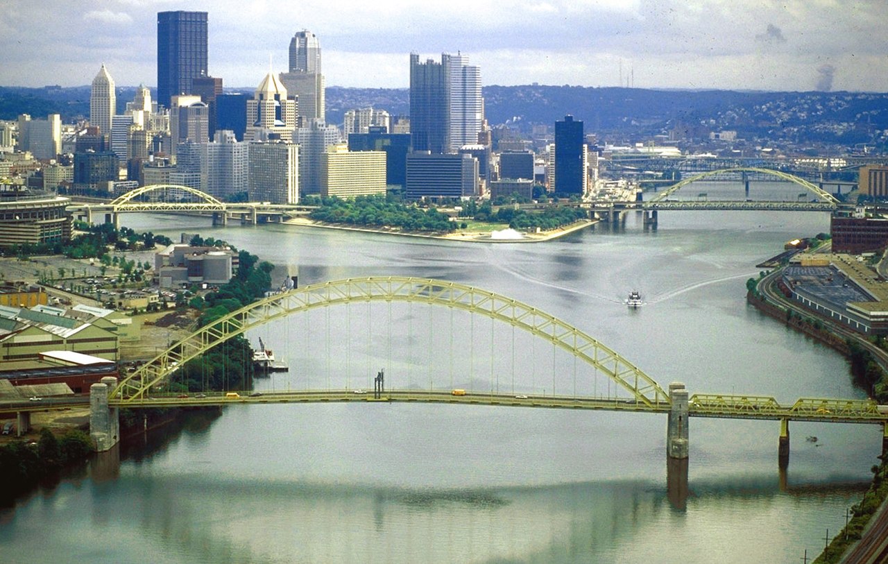
The Ohio River is formed by the confluence of the Allegheny and Monongahela rivers at what is now Point State Park in Pittsburgh, Pennsylvania. From there, it flows northwest through Allegheny and Beaver counties, before making an abrupt turn to the south-southwest at the West Virginia–Ohio–Pennsylvania triple-state line (near East Liverpool, Ohio; Chester, West Virginia; and Ohioville, Pennsylvania). From there, it forms the border between West Virginia and Ohio, upstream of Wheeling, West Virginia.
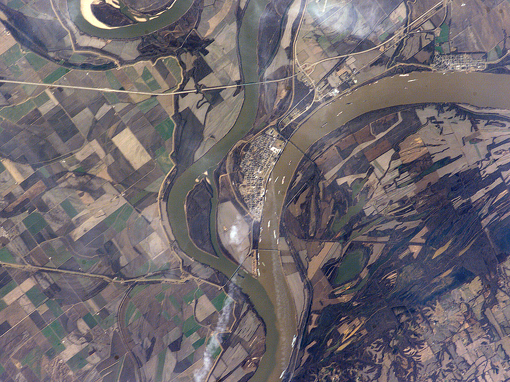
The river follows a roughly southwest and then west-northwest course until Cincinnati, before bending to a west-southwest course for most of the remainder of its length. The course forms the northern borders of West Virginia and Kentucky; and the southern borders of Ohio, Indiana and Illinois, until it joins the Mississippi River at the city of Cairo, Illinois. Where the Ohio joins the Mississippi is the lowest elevation in the state of Illinois, at 315 feet (96 m).
The Mississippi River flows to the Gulf of Mexico on the Atlantic Ocean. Among rivers wholly or mostly in the United States, the Ohio is the second largest by discharge volume and the tenth longest and has the eighth largest drainage basin. It serves to separate the Midwestern Great Lakes states from the Upper South states, which were historically border states in the Civil War.
The Ohio River is a left (east) and the largest tributary by volume of the Mississippi River in the United States. At the confluence, the Ohio is considerably bigger than the Mississippi, measured by long-term mean discharge. The Ohio River at Cairo is 281,500 cu ft/s (7,960 m3/s); and the Mississippi River at Thebes, Illinois, which is upstream of the confluence, is 208,200 cu ft/s (5,897 m3/s). The Ohio River flow is greater than that of the Mississippi River, so hydrologically the Ohio River is the main stream of the river system.
River depth
The Ohio River is a naturally shallow river that was artificially deepened by a series of dams. The natural depth of the river varied from about 3 to 20 feet (1 to 6 m). The dams raise the water level and have turned the river largely into a series of reservoirs, eliminating shallow stretches and allowing for commercial navigation. From its origin to Cincinnati, the average depth is approximately 15 feet (5 m). The largest immediate drop in water level is below the McAlpine Locks and Dam at the Falls of the Ohio at Louisville, Kentucky, where flood stage is reached when the water reaches 23 feet (7 m) on the lower gauge. However, the river's deepest point is 168 feet (51 m) on the western side of Louisville, Kentucky. From Louisville, the river loses depth very gradually until its confluence with the Mississippi at Cairo, Illinois, where it has an approximate depth of 19 feet (6 m).
Water levels for the Ohio River from Smithland Lock and Dam upstream to Pittsburgh are predicted daily by the National Oceanic and Atmospheric Administration's Ohio River Forecast Center. The water depth predictions are relative to each local flood plain based upon predicted rainfall in the Ohio River basin in five reports as follows:
Pittsburgh, Pennsylvania, to Hannibal Locks and Dam, Ohio (including the Allegheny and Monongahela rivers)
Willow Island Locks and Dam, Ohio, to Greenup Lock and Dam, Kentucky (including the Kanawha River)
Portsmouth, Ohio, to Markland Locks and Dam, Kentucky
McAlpine Locks and Dam, Kentucky, to Cannelton Locks and Dam, Indiana
Newburgh Lock and Dam, Indiana, to Golconda, Illinois
The water levels for the Ohio River from Smithland Lock and Dam to Cairo, Illinois, are predicted by the National Oceanic and Atmospheric Administration's Lower Mississippi River Forecast Center.