
Lake Erie ( EER-ee) is the fourth-largest lake by surface area of the five Great Lakes in North America and the eleventh-largest globally. It is the southernmost, shallowest, and smallest by volume of the Great Lakes and also has the shortest average water residence time. At its deepest point, Lake Erie is 210 feet (64 m) deep, making it the only Great Lake whose deepest point is above sea level.
Located on the International Boundary between Canada and the United States, Lake Erie's northern shore is the Canadian province of Ontario, specifically the Ontario Peninsula, with the U.S. states of Michigan, Ohio, Pennsylvania, and New York on its western, southern, and eastern shores. These jurisdictions divide the surface area of the lake with water boundaries. The largest city on the lake is Cleveland, anchoring the third largest U.S. metro area in the Great Lakes region, after Greater Chicago and Metro Detroit. Other major cities along the lake shore include Buffalo, New York; Erie, Pennsylvania; and Toledo, Ohio.
Situated below Lake Huron, Erie's primary inlet is the Detroit River. The main natural outflow from the lake is via the Niagara River, which provides hydroelectric power to Canada and the U.S. as it spins huge turbines near Niagara Falls at Lewiston, New York, and Queenston, Ontario. Some outflow occurs via the Welland Canal, part of the Saint Lawrence Seaway, which diverts water for ship passages from Port Colborne, Ontario, on Lake Erie, to St. Catharines on Lake Ontario, an elevation difference of 326 ft (99 m). Lake Erie's environmental health has been an ongoing concern for decades, with issues such as overfishing, pollution, algae blooms, aquatic invasive species, and eutrophication generating headlines.

Etymology
Lake Erie appeared on maps as Lac du Chat as early as 1650. René de Bréhant de Galinée recorded the name of the lake as Lac Érié around 1670. The name Erie is derived from the Iroquoian word erielhonan, meaning "long tail".
Geography
Geographic features
Lake Erie (42.2° N, 81.2W) has a mean elevation of 571 feet (174 m) above sea level. It has a surface area of 9,910 square miles (25,667 km2) with a length of 241 statute miles (388 km; 209 nmi) and breadth of 57 statute miles (92 km; 50 nmi) at its widest points. It is the shallowest of the Great Lakes with an average depth of 10 fathoms 3 feet or 63 ft (19 m) and a maximum depth of 35 fathoms (210 ft; 64 m) Although Lake Erie is the shallowest of the Great Lakes, its basin lies at a relatively high elevation, the lake's deepest point remains above the surface elevation of Lake Ontario, into which the Great Lakes system drains via the Niagara River and Niagara Falls.
Because Erie is the shallowest, it is also the warmest of the Great Lakes, and in 1999 this almost became a problem for two nuclear power plants which require cool lake water to keep their reactors cool. The warm summer of 1999 caused lake temperatures to come close to the 85 °F (29 °C) limit necessary to keep the plants cool. Also because of its shallowness, it is the first to freeze in the winter.

The shallowest section of Lake Erie is the western basin where depths average only 25 to 30 feet (7.6 to 9.1 m); as a result, "the slightest breeze can kick up lively waves", also known as seiches. The "waves build very quickly", according to other accounts. The region around the lake is known as the "thunderstorm capital of Canada" with "breathtaking" lightning displays. Sometimes fierce waves springing up unexpectedly have led to dramatic rescues; in one instance, a Cleveland resident was trapped by churning surf with six foot waves near his dock, but was rescued by a fire department diver from Avon Lake, Ohio:
In a tug of war against the waves, the two were finally hauled out by rope. After being trapped for an hour-and-a-half, Baker was back on dry land, exhausted and battered but alive.
Lake Erie is primarily fed by the Detroit River (from Lake Huron and Lake St. Clair) and drains via the Niagara River and Niagara Falls into Lake Ontario. Navigation downstream is provided by the Welland Canal, part of the Saint Lawrence Seaway. Other major contributors to Lake Erie include Grand River, Huron River, Maumee River, Sandusky River, Cuyahoga River, and Buffalo River. The drainage basin covers 30,140 square miles (78,100 km2).

Point Pelee National Park, the southernmost point of the Canadian mainland, is located on a peninsula extending into the lake. Lake Erie has 31 islands (13 in Canada, 18 in the U.S.), located generally in the western side of the lake. The largest of these is Pelee Island.
Water levels
Lake Erie has a lake retention time of 2.6 years, the shortest of all the Great Lakes. The lake's surface area is 9,910 square miles (25,667 km2). Lake Erie's water level fluctuates with the seasons as in the other Great Lakes. Generally, the lowest levels are in January and February and the highest in June or July, although there have been exceptions. The average yearly level varies depending on long-term precipitation. Short-term level changes are often caused by seiches that are particularly high when southwesterly winds blow across the length of the lake during storms. These cause water to pile up at the eastern end of the lake. Storm-driven seiches can cause damage onshore. During one storm in November 2003, the water level at Buffalo rose by 7 feet (2.1 m) with waves of 10–15 feet (3.0–4.6 metres) for a rise of 22 feet (6.7 m). Meanwhile, at the western end of the lake, Toledo experienced a similar drop in water level.
Historic High Water. In the summer of 1986, Lake Erie reached its highest level at 5.08 feet (1.55 m) above the datum. The high water records were set from April 1986 through January 1987. Levels ranged from 4.33 to 5.08 feet (1.32–1.55 m) above the datum.
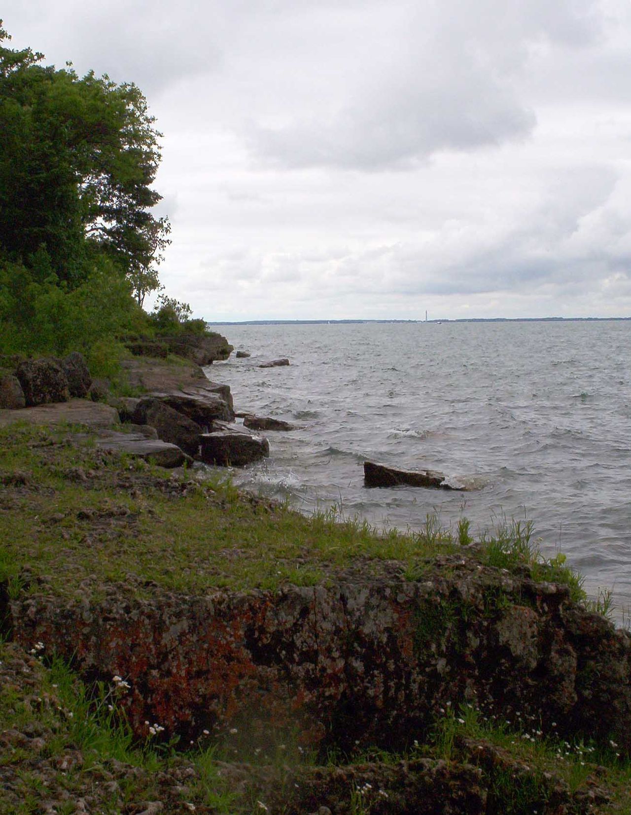
Historic Low Water. In the winter of 1934, Lake Erie reached its lowest level at 1.5 feet (0.46 m) below the datum. Monthly low water records were set from July 1934 through June 1935. During these twelve months water levels ranged from 1.5 feet (0.46 m) below the datum to even with the datum.
Geology
Lake Erie was carved out by glacier ice and went through many phases before its current form which is less than 4,000 years old, which is a short span in geological terms. Before this, the land on which the lake now sits went through several complex stages. A large lowland basin formed over two million years ago as a result of an eastern flowing river that existed well before the Pleistocene ice ages. This ancient drainage system was destroyed by the first major glacier in the area, while it deepened and enlarged the lowland areas, allowing water to settle and form a lake. The glaciers were able to carve away more land on the eastern side of the lowland because the bedrock is made of shale which is softer than the carbonate rocks of dolomite and limestone on the western side. The lake basin is divided into distinct eastern, central basin, and western basin sub-basins, with especially shallow conditions in the western basin, which averages only 25 feet (7.6 m) deep and is rich in nutrients and fish. Geological analyses indicate that differential glacial erosion, and the influence of structural features such as the Niagara Escarpment, limited the extent of overdeepening when compared with Lake Superior and Lake Ontario.
As many as three glaciers advanced and retreated over the land, causing temporary lakes to form in the time periods in between each of them (see: Lake Whittlesey, Lake Maumee and Lake Arkona). Because each lake had a different volume of water, their shorelines rested at differing elevations. The last lake to form, Lake Warren, existed between about 13,000 and 12,000 years ago. It was deeper than the current Lake Erie, and its shoreline existed about eight miles (13 km) inland from the modern one. Early Lake Erie went through many phases with its ancient sand dunes visible in the Oak Openings Region in Northwest Ohio. There, the sandy dry lake bed soil was not sufficient to support large trees with the exception of a few species of oaks, forming a rare oak savanna.

History
Indigenous peoples
At the time of European contact, there were several Indigenous peoples living around the shores of the eastern end of the lake. The Erie tribe (from whom the lake takes its name) lived along the southern edge, while the Neutrals (also known as Attawandaron) lived along the northern shore. The tribal name "erie" is a shortened form of the Iroquoian word erielhonan, meaning "long tail". The name may also come from the word eri, meaning "cherry tree". Near Port Stanley, there is an Indigenous village dating from the 16th century known as the Southwold Earthworks where as many as 800 Neutral Indigenous peoples once lived; the archaeological remains include double earth walls winding around the grass-covered perimeter. Europeans named the tribe the Neutral Indians since these people refused to fight with other tribes.
Both the Erie and Neutrals were colonized and assimilated by their hostile eastern neighbors, the Iroquois Confederacy, between 1651 and 1657 during the Beaver Wars. For decades after those wars, the land around eastern Lake Erie was claimed and utilized by the Iroquois as a hunting ground. As the power of the Iroquois waned during the last quarter of the 17th century, several other, mainly Anishinaabe, displaced them from the territories they claimed on the north shore of the lake. There was a legend of an Indigenous woman named Huldah, who, despairing over her lost British lover, hurled herself from a high rock from Pelee Island.
European exploration and settlement
In 1669, Frenchman Louis Jolliet was the first documented European to sight Lake Erie, although there is speculation that Étienne Brûlé may have come across it in 1615. Lake Erie was the last of the Great Lakes to be explored by Europeans, since the Iroquois who occupied the Niagara River area were in conflict with the French, and they did not allow explorers or traders to pass through; explorers followed rivers out of Lake Ontario and portaged to Lake Huron. British authorities in Canada were nervous about possible expansion by American settlers across Lake Erie, so Colonel Thomas Talbot developed the Talbot Trail in 1809 as a way to stimulate settlement to the area; Talbot recruited settlers from Ireland and Scotland, and there are numerous places named after him in southern Ontario, such as Port Talbot, the Talbot River, and Talbotville.
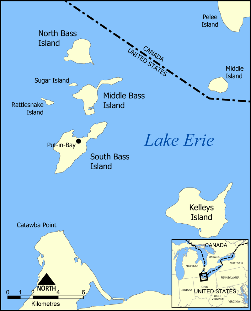
During the War of 1812, a United States Navy squadron under Oliver Hazard Perry captured a smaller Royal Navy squadron near Put-in-Bay, Ohio at the 1813 Battle of Lake Erie. As part of the conflict, American troops made repeated raids throughout the Ontario area around Port Rowan, burning towns and villages. Generally, however, with the exceptions of the American Revolutionary War and the War of 1812—which were conflicts between the U.S. and Britain—relations between the U.S. and Canada have been remarkably friendly with an "unfortified boundary" and an agreement "that has kept all fleets of war off the Great Lakes."
In 1837, the Lower Canada Rebellion broke out. These primarily concerned political reforms and land allocation issues. Some of the rebels stationed themselves in the U.S. and crossed the ice from Sandusky Bay to Pelee Island wearing "tattered overcoats and worn-out boots", and carrying muskets, pitchforks, and swords, but the islanders had already fled. Later, there was a battle on the ice with the Royal 32nd Regiment, with the rebels being driven to retreat.
Settlers established commercial fisheries on the north coast of the lake around the 1850s. An important business was fishing. In the pre-Civil War years, railways sprouted everywhere, and around 1852 there were railways circling the lake. Maritime traffic picked up, although the lake was usually closed because of ice from December to early April, and ships had to wait for the ice to clear before proceeding. Since slavery had been abolished in Canada in 1833 but was still legal in southern U.S., a Lake Erie crossing was sometimes required for fugitive slaves seeking freedom:
When Kentucky fugitive Lewis Clarke arrived in Cleveland, he had no idea how to find Canada. "I went out to the shore of the lake again and again, to try and see the other side, but I could see no hill, mountain, nor city of the asylum I sought," he once told an interviewer. "I was afraid to inquire where (Canada) was, lest it would betray such a degree of ignorance as to excite suspicion at once." Many fugitives also had to overcome fears instilled by their former masters ...
Prior to modern radar and weather forecasting, merchant ships were often caught up in intense gales:
A violent gale is blowing on Lake Erie ... The schooner Stranger came in this morning and reports seeing a vessel about 12 miles [19 km] up, 2 miles [3.2 km] from the Canada shore, with three men clinging to the masts, which alone were visible above the water–heard their cries and screams ...
There were reports of disasters usually from sea captains passing information to reporters; in 1868, the captain of the Grace Whitney saw a sunken vessel with "three men clinging to the masthead," but he could not help because of the gale and high seas.
A balloonist named John Steiner of Philadelphia made an ambitious trip across the lake in 1857. His voyage was described in The New York Times:
He arose to the height of about three miles, and started off at a slow but steady rate ... The lake could be seen from one end to the other nearly ... At one time Mr. Steiner counted 38 sail vessels, all in sight, and far below him. The hands on board several of the vessels saw him, and rightly apprehending that he was an aeronaut, cheered him heartily ... He neared the Canada shore a little below Long Point ... he was accordingly driven towards Buffalo ... Night was drawing on and it became apparent that he could not, with this current, get away from the water before dark, and after nightfall it would not be safe to come down. Seeing a propeller (powered boat) ... the Mary Stewart ... He first struck the water about 25 miles below Long Point ... During this time Mr. Steiner says he thinks his balloon bounded from the water at least twenty times. It would strike and then rebound, like a ball, going into the air from twenty to fifty feet, and still rushing down the lake at railroad speed ... Mr. Steiner then abandoned the balloon, leaping into the water and swimming towards the boat, which speedily reached him ...
In 1885, lake winds were so strong that water levels dropped substantially, sometimes by as much as two feet, so that at ports such as Toledo, watercraft could not load coal or depart the port. During the history of the lake as a fishery, there has been marked battling by opposing interest groups:
The preservation of the fisheries of Lake Erie has become a serious problem to all who have given it close attention ... the fisheries are being exhausted by the wasteful methods which are now in vogue ... it is still the custom of the pound fishermen about Sandusky to take fish of all sizes, and if they are too small to be marketable they are turned over to a fertilizer factory. If left undisturbed for two or three years more, these little fish would be a very valuable product ...
Predictions of the lake being over-fished in 1895 were premature, since the fishery has survived commercial and sport fishing, pollution in the middle of the 20th century, invasive species and other ailments, but state and provincial governments, as well as national governments, have played a greater role as time went by. Business boomed; in 1901, the Carnegie Company proposed building a new harbor near Erie, Pennsylvania, in Elk Creek to accommodate shipments from its tube-plant site nearby. In 1913, a memorial to Commodore Oliver Hazard Perry was built on Put-in-Bay island featuring a Doric column.
Steamships have operated on Lake Erie since the early 1800s. Large, opulent cruise liners carried passengers between Detroit, Cleveland, Buffalo and other cities on the lake until the rise of the automobile in the 1950s drastically cut demand for their services. The Detroit and Cleveland Navigation Company was one of the largest and most renowned of these companies.
During the Prohibition years from 1919 to 1933, a "great deal of alcohol crossed Erie" along with "mobster corpses" dumped into the Detroit River which sometimes washed up on the beaches of Pelee Island. Notable rum runners included Thomas Joseph McGinty and the Purple Gang. The Coast Guard attempted to interdict the Canadian liquor with its Rum Patrol, and a casino operated on Middle Island.
During the 20th century, commercial fishing was prevalent but so was the boom in manufacturing industry around the lake, and often rivers and streams were used as sewers to flush untreated sewage which ended up in the lake. Sometimes poorly constructed sanitary systems meant that when old pipes broke, raw sewage would spill directly into the Cuyahoga River and into the lake. A report in Time magazine in 1969 described the lake as a "gigantic cesspool" since only three of 62 beaches were rated "completely safe for swimming".
By 1975 the popular commercial fish blue pike had been declared extinct, although the declaration may have been premature. By the 1980s, there were about 130 fishing vessels with about 3,000 workers, but commercial fishing was declining rapidly, particularly from the American side.
Great Lakes Compact
In 2005, the Great Lakes states of Ohio, Michigan, New York, Pennsylvania, Illinois, Indiana, Wisconsin, and Minnesota and the Canadian Provinces of Ontario and Quebec endorsed the Great Lakes-St. Lawrence River Basin Sustainable Water Resources Compact. It was signed into law by President George W. Bush in September 2008. An international water-rights policy overseen by the Great Lakes Commission, the compact aims to prevent diversion of water from Great Lakes to distant states, as well as to set standards for use and conservation. It had support from both political parties, including United States Senator George Voinovich of Ohio and Governor Jennifer Granholm of Michigan, but is not popular in the southwestern states because of frequent drought conditions and water scarcity.
Lake environment
Climate
Lake Erie in winter
Like the other Great Lakes, Erie produces lake-effect snow when the first cold winds of winter pass over the warm waters. When the temperatures of the relatively warm surface water and the colder air separate to at least 18 °F (10 °C) to 23 °F (13 °C) apart, then "lake-effect snow becomes possible:"
As cold air flows over the warm water, the lake warms and moistens the air. Since warm, moist air is less dense than cold air, the heated air rises. Rising air cools and water vapor condenses into cloud droplets ... the efficiency of snow production increases when the wind pushes the clouds over land. Friction with the ground causes air to pile up. This frictional convergence creates lift and enhances snowfall.
Heavy lake-effect snowfalls can occur when cold air travels 60 miles (97 km) or longer over a large unfrozen lake. Lake-effect snow makes Buffalo and Erie the eleventh and thirteenth-snowiest cities in the contiguous United States, respectively, according to data collected from the National Climatic Data Center. Since winds blow primarily west to east along the main axis of the lake, lake-effect snowstorms are more pronounced on the eastern parts of the lake. Buffalo typically gets 95 inches (240 cm) of snow each winter and sometimes ten feet (3.0 m) of snow; the snowiest city is Syracuse, New York, which can receive heavy snowfall from both the lake effect process and large coastal cyclones. A storm around Christmas in 2001 pounded Buffalo with 7 feet (2.1 m) of snow.
The effects of the warmer lake water is reduced when the lake freezes over. In January 2011, for example, residents of Cleveland were glad when Lake Erie was "90 percent frozen" since it meant that the area had "made it over the hump" in terms of enduring repeated snowfalls which required much shoveling. Being the shallowest of the Great Lakes, it is the most likely to freeze and frequently does. In contrast, Lake Michigan has never completely frozen over since the warmer and deeper portion is in the south, although it came close to being totally frozen during three harsh winters over the past century. In past years, lake ice was so thick that it was possible to drive over it or go sailing on iceboats. Many lake residents take advantage of the ice and travel; some drive to Canada and back:
The first ice usually forms in late November, and by January, it locks into place. For islanders in the Western Basin, it is the equivalent of summer vacation ... Once the lake freezes, islanders organize impromptu ice rallies. Families gather to drink hot wine and race all-terrain vehicles across the lake. They also race iceboats, which resemble sailboats on skates ... Many people drive to other islands for dinner with friends. They ride in cars with the roofs and doors chopped off so they can escape if the vehicles fall through the ice. Islanders stab evergreen trees into the ice every 50 yards [46 m] to mark a route ... Even in the coldest winters, there are dangerous patches of thin ice. The cracks are so predictable that the Put-in-Bay Ice Yacht Club prints them on a map ... On a normal winter day, the ice is dotted with 2,000 fishing shanties.
Windy conditions
Strong winds have caused lake currents to shift sediment on the bottom, leading to shifting sandbars that have been the cause of shipwrecks. But winds can have a peaceful purpose as well; there have been proposals to place electricity–producing wind turbines in windy and shallow points in the lake and along the coast. Steel Winds, a former steel mill site in Buffalo, has been developed as an urban wind farm housing 14 turbines capable of generating up to 35 megawatts of electricity. A plan by Samsung to build an offshore wind farm on the north shore of the lake, from Port Maitland to Nanticoke for a distance of 15.5 mi (24.9 km), has been met with opposition from residents. Canadians near Leamington and Kingsville have organized protest groups to thwart attempts to bring wind turbines to the lake; reasons against the turbines include spoiling lake views. Plans to install turbines in Pigeon Bay, south of Leamington were met with opposition as well. The notion that bird and bat migration may be hurt by the wind turbines has been used to argue against the wind turbines as well.
Microclimates
The lake is responsible for microclimates that are important to agriculture. Along its north shore is one of the richest areas of Canada's fruit and vegetable production; this southernmost tip, particularly in the area around Leamington, is known as Canada's "tomato capital". The area around Port Rowan has special trees that grow because of the "tempering effect of the lake", and species include tulip trees, dogwood, sassafras, and sour gum. This area's many greenhouses produce a "variety of tropical plants rarely cultivated so far north", including some species of cacti, because of the lake's tempering effect. Along the southeastern shore of Ohio, Pennsylvania, and New York is an important grape-growing region, as are the islands in the lake. Apple orchards are abundant in northeast Ohio to western New York.
Long-term weather patterns
According to one estimate, 34 to 36 inches (860 to 910 mm) of water evaporate each year from the surface of the lake, which allows for rainfall and other precipitation in surrounding areas. Reports are conflicting about the overall effect of global warming on the Great Lakes region, including Lake Erie. One account suggests that climate change is causing greater evaporation of lake water, leading to warmer temperatures, as well as thinner or nonexistent ice in winter, which is fueling concerns that "Erie appears to be shrinking" and is the most likely candidate among the five Great Lakes to "turn into a festering mud puddle." In 2010, the Windsor Star reported that the lake experienced record-breaking water temperatures, reaching 81 °F (27 °C) in mid-August and compared the lake to a "bath tub".
Ecosystems
Lake Erie has a complex ecosystem with many species in interaction. Human activity, such as pollution and maritime ship traffic, can affect this environment in numerous ways. The interactions between invasive species can sometimes have beneficial effects, though harmful effects are more likely. Some introductions have been seen as beneficial such as the introduction of Pacific salmon. Occasionally there have been mass die-offs of certain species of fish, sometimes for reasons unknown, such as many numbers of rainbow smelt in May 2010.