
The Klondike Gold Rush was a migration by an estimated 100,000 prospectors to the Klondike region of Yukon in northwestern Canada, between 1896 and 1898. Gold was discovered there by local miners on August 16, 1896; when news reached Seattle and San Francisco the following year, it triggered a stampede of prospectors. Some became wealthy, but the majority went in vain. It has been immortalized in films, literature, and photographs.
To reach the gold fields, most prospectors took the route through the ports of Dyea and Skagway in southeast Alaska. Here, the "Klondikers" could follow either the Chilkoot or White Pass trail to the Yukon River and sail down to the Klondike. The Canadian authorities required each person to bring a year's supply of food in order to prevent starvation. In all, the Klondikers' equipment weighed close to a ton, which most carried themselves in stages. Performing this task and contending with the mountainous terrain and cold climate meant that most of those who persisted did not arrive until the summer of 1898. Once there, they found few opportunities, and many left disappointed.
To accommodate the prospectors, boom towns sprang up along the routes. At their terminus, Dawson City was founded at the confluence of the Klondike and Yukon rivers. From a population of 500 in 1896, the town grew to house approximately 17,000 people by summer 1898. Built of wood, isolated, and unsanitary, Dawson suffered from fires, high prices, and epidemics. Despite this, the wealthiest prospectors spent extravagantly, gambling and drinking in the saloons. The indigenous Hän, on the other hand, suffered from the rush; they were forcibly moved into a reserve to make way for the Klondikers, and many died.

Beginning in 1898, the newspapers that had encouraged so many to travel to the Klondike lost interest in it. In the summer of 1899, gold was discovered around Nome in west Alaska, and many prospectors left the Klondike for the new goldfields, marking the end of the Klondike Rush. The boom towns declined, and the population of Dawson City fell. Gold mining production in the Klondike peaked in 1903 after heavier equipment was brought in. Since then, the Klondike has been mined on and off, and its legacy continues to draw tourists to the region and contribute to its prosperity. An estimated 14,000,000 oz (400,000,000 g) of gold has been taken from the area (until 2013), of which half came from Bonanza Creek and a quarter from Hunker Creek.
Background
The indigenous peoples in north-west America had traded in copper nuggets prior to European expansion. Most of the tribes were aware that gold existed in the region, but the metal was not valued by them. The Russians and the Hudson's Bay Company had both explored the Yukon in the first half of the 19th century, but ignored the rumours of gold in favour of fur trading, which offered more immediate profits.
In the second half of the 19th century, American prospectors began to spread into the area. Making deals with the Native Tlingit and Tagish tribes, the early prospectors opened the important routes of Chilkoot and White Pass and reached the Yukon valley between 1870 and 1890. Here, they encountered the Hän people, semi-nomadic hunters and fishermen who lived along the Yukon and Klondike Rivers. The Hän did not appear to know about the extent of the gold deposits in the region.

In 1883, Ed Schieffelin identified gold deposits along the Yukon River, and an expedition up the Fortymile River in 1886 discovered considerable amounts of it and founded Fortymile City. The same year gold had been found on the banks of the Klondike River, but in small amounts and with no claims being made. By late 1886, several hundred miners were working their way along the Yukon valley, living in small mining camps and trading with the Hän. On the Alaskan side of the border, Circle City, a logtown, was established in 1893 on the Yukon River. In three years it grew to become "the Paris of Alaska", with about 1,200 inhabitants, saloons, opera houses, schools, and libraries. In 1896, it was so well-known that a correspondent from the Chicago Daily Record came to visit. At the end of the year, it became a ghost town, when large gold deposits were found upstream on the Klondike.
Discovery (1896)
On August 16, 1896, an American prospector named George Carmack and two Tagish men, Skookum Jim (Keish), and Tagish Charlie (K̲áa Goox̱) were travelling south of the Klondike River. Following a suggestion from Robert Henderson, a Canadian prospector, they began looking for gold on Bonanza Creek, then called Rabbit Creek, one of the Klondike's tributaries. It is not clear who discovered the gold: George Carmack or Skookum Jim, but the group agreed to let George Carmack appear as the official discoverer because they feared that authorities would not recognize an indigenous claimant.
In any event, gold was present along the river in huge quantities. Carmack measured out four strips of ground for mining along the river, two for himself as the discoverer and one each for Jim and Charlie. These claims were registered the next day at the police post at the mouth of the Fortymile River and news spread rapidly from there to other mining camps in the Yukon River valley.

By the end of August, all of Bonanza Creek had been claimed by miners. A prospector then advanced up into one of the creeks feeding into the Bonanza, later to be named Eldorado Creek. He discovered new sources of gold there, which would prove to be even richer than those on the Bonanza. Claims began to be sold between miners and speculators for considerable sums. Just before Christmas, word of the gold reached Circle City. Despite the winter, many prospectors immediately left for the Klondike by dog-sled, eager to reach the region before the best claims were taken. The outside world was still largely unaware of the news, and although Canadian officials had managed to send a message to their superiors in Ottawa about the finds and influx of prospectors, the government did not give it much attention. The winter prevented river traffic, and it was not until June 1897 that the first boats left the area, carrying the freshly mined gold and the full story of the discoveries.
Beginning of the stampede (July 1897)
In the resulting Klondike stampede, an estimated 100,000 people tried to reach the Klondike goldfields, though only around 30,000 to 40,000 eventually did. The height of the Klondike gold rush was from the summer of 1897 to the summer of 1898.
It began on July 14, 1897, in San Francisco and was spurred further three days later in Seattle, when the first of the early prospectors returned from the Klondike, bringing with them large amounts of gold on the ships Excelsior and Portland. The press reported that a total of $1,139,000 (equivalent to $1 billion at 2010 prices) had been brought in by these ships, although this proved to be an underestimate. The migration of prospectors caught so much attention that it was joined by outfitters, writers and photographers.
Various factors lay behind this sudden mass response. Economically, the news had reached the US at the height of a series of financial recessions and bank failures in the 1890s. The gold standard of the time tied paper money to the production of gold and shortages towards the end of the 19th century meant that gold dollars were rapidly increasing in value ahead of paper currencies and being hoarded. This had contributed to the Panic of 1893 and Panic of 1896, which caused unemployment and financial uncertainty. There was a huge, unresolved demand for gold across the developed world that the Klondike promised to fulfil and, for individuals, the region promised higher wages or financial security.
Psychologically, the Klondike, as historian Pierre Berton describes, was "just far enough away to be romantic and just close enough to be accessible". Furthermore, the Pacific ports closest to the gold strikes were desperate to encourage trade and travel to the region. The mass journalism of the period promoted the event and the human interest stories that lay behind it. A worldwide publicity campaign engineered largely by Erastus Brainerd, a Seattle newspaperman, helped establish that city as the premier supply centre and the departure point for the gold fields.
The prospectors came from many nations, although an estimated majority of 60 to 80 percent were Americans or recent immigrants to America. Most had no experience in the mining industry, being clerks or salesmen. Mass resignations of staff to join the gold rush became notorious. In Seattle, this included the mayor, twelve policemen, and a significant percentage of the city's streetcar drivers.

Some stampeders were famous: John McGraw, the former governor of Washington, joined, together with the prominent lawyer and sportsman A. Balliot. Frederick Burnham, a well-known American scout and explorer, arrived from Africa, only to be called back to take part in the Second Boer War. Among those who documented the rush was the Swedish-born photographer Eric Hegg, who took some of the iconic pictures of Chilkoot Pass, and reporter Tappan Adney, who afterwards wrote a first-hand history of the stampede. Jack London, later a famous American writer, left to seek for gold but made his money during the rush mostly by working for prospectors. Friedrich Trump, grandfather of later US president Donald Trump, had arrived in the U.S. in 1885. He joined the gold rush as a provider.
Seattle and San Francisco competed fiercely for business during the rush, with Seattle winning the larger share of trade. Indeed, one of the first to join the gold rush was William D. Wood, the mayor of Seattle, who resigned and formed a company to transport prospectors to the Klondike.
The publicity around the gold rush led to a flurry of equipment adding "Klondike" to the name, allegedly designed for the northwest. Guidebooks offered advice about routes, equipment, mining, and costs. The newspapers of the time termed this phenomenon "Klondicitis".

Routes to the Klondike
The Klondike could be reached only by the Yukon River, either upstream from its delta, downstream from its head, or from somewhere in the middle through its tributaries. River boats could navigate the Yukon in the summer from the delta until a point called Whitehorse, above the Klondike. Travel, in general, was made difficult by both terrain and climate. The region was mountainous, the rivers winding and sometimes impassable; summers, albeit short, still brought heat, while during the long winters, temperatures could drop below −50 °C (−58 °F).
Aids for the travellers to carry their supplies varied; some had brought dogs, horses, mules, or oxen, whereas others had to rely on carrying their equipment on their backs or on sleds pulled by hand. Shortly after the stampede began in 1897, the Canadian authorities introduced rules requiring anyone entering Yukon Territory to bring with them a year's supply of food; typically this weighed around 1,150 pounds (520 kg). By the time camping equipment, tools and other essentials were included, a typical traveller was transporting as much as a ton in weight. Unsurprisingly, the price of draft animals soared; at Dyea, even poor quality horses could sell for as much as $700 ($25,083 in 2025), or be rented out for $40 ($1,433 in 2025) a day.
From Seattle or San Francisco, prospectors could travel by sea up the coast to the ports of Alaska. The route following the coast is now referred to as the Inside Passage. It led to the ports of Dyea and Skagway plus ports of nearby trails. The sudden increase in demand encouraged a range of vessels to be pressed into service including old paddle wheelers, fishing boats, barges, and coal ships still full of coal dust. All were overloaded and many sank.
All water routes
It was possible to sail all the way to the Klondike, first from Seattle across the northern Pacific to the Alaskan coast. From St. Michael, at the Yukon River delta, a river boat could then take the prospectors the rest of the way up the river to Dawson, often guided by one of the Native Koyukon people who lived near St. Michael. Although this all-water route, also called "the rich man's route", was expensive and long – 4,700 miles (7,600 km) in total – it had the attraction of speed and avoiding overland travel. At the beginning of the stampede a ticket could be bought for $150 ($5,375 in 2025) while during the winter 1897–98 the fare settled at $1,000 ($38,700 in 2025).
In 1897, some 1,800 travellers attempted this route but the vast majority were caught along the river when the region iced over in October. Only 43 reached the Klondike before winter and of those 35 had to return, having thrown away their equipment en route to reach their destination in time. The remainder mostly found themselves stranded in isolated camps and settlements along the ice-covered river often in desperate circumstances.
Dyea/Skagway routes
Most of the prospectors landed at the southeast Alaskan towns of Dyea and Skagway, both located at the head of the natural Lynn Canal at the end of the Inside Passage. From there, they needed to travel over the mountain ranges into Canada's Yukon Territory, and then down the river network to the Klondike. Along the trails, tent camps sprung up at places where prospectors had to stop to eat or sleep or at obstacles such as the icy lakes at the head of the Yukon. At the start of the rush, a ticket from Seattle to the port of Dyea cost $40 ($1,433 in 2025) for a cabin. Premiums of $100 ($3,583 in 2025), however, were soon paid and the steamship companies hesitated to post their rates in advance since they could increase on a daily basis.
White Pass trail
Those who landed at Skagway made their way over the White Pass before cutting across to Bennett Lake. Although the trail began gently, it progressed over several mountains with paths as narrow as 2 feet (0.61 m) and in wider parts covered with boulders and sharp rocks. Under these conditions horses died in huge numbers, giving the route the informal name of Dead Horse Trail. The volumes of travellers and the wet weather made the trail impassable and, by late 1897, it was closed until further notice, leaving around 5,000 stranded in Skagway.
An alternative toll road suitable for wagons was eventually constructed and this, combined with colder weather that froze the muddy ground, allowed the White Pass to reopen, and prospectors began to make their way into Canada. Moving supplies and equipment over the pass had to be done in stages. Most divided their belongings into 65 pounds (29 kg) packages that could be carried on a man's back, or heavier loads that could be pulled by hand on a sled. Ferrying packages forwards and walking back for more, a prospector would need about thirty round trips, a distance of at least 2,500 miles (4,000 km), before they had moved all of their supplies to the end of the trail. Even using a heavy sled, a strong man would be covering 1,000 miles (1,600 km) and need around 90 days to reach Lake Bennett.
Chilkoot trail
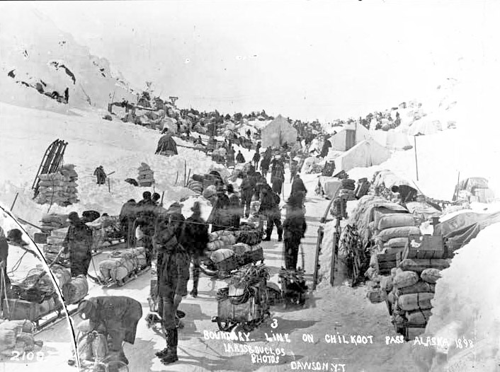
Those who landed at Dyea, Skagway's neighbour town, travelled the Chilkoot Trail and crossed its pass to reach Lake Lindeman, which fed into Lake Bennett at the head of the Yukon River. The Chilkoot Pass was higher than the White Pass, but more used it: around 22,000 during the gold rush. The trail passed up through camps until it reached a flat ledge, just before the main ascent, which was too steep for animals. This location was known as the Scales, and was where goods were weighed before travellers officially entered Canada. The cold, the steepness and the weight of equipment made the climb extremely arduous and it could take a day to get to the top of the 1,000 feet (300 m) high slope.
As on the White Pass trail, supplies needed to be broken down into smaller packages and carried in relay. Packers, prepared to carry supplies for cash, were available along the route but would charge up to $1 ($35.83 in 2025) per lb (0.45 kg) on the later stages; many of these packers were natives: Tlingits or, less commonly, Tagish. Avalanches were common in the mountains and, on April 3, 1898, one claimed the lives of more than 60 people travelling over Chilkoot Pass.
Entrepreneurs began to provide solutions as the winter progressed. Steps were cut into the ice at the Chilkoot Pass which could be used for a daily fee, this 1,500 step staircase becoming known as the "Golden Steps". By December 1897, Archie Burns built a tramway up the final parts of the Chilkoot Pass. A horse at the bottom turned a wheel, which pulled a rope running to the top and back; freight was loaded on sledges pulled by the rope. Five more tramways soon followed, one powered by a steam engine, charging between 8 and 30 cents per 1 pound (0.45 kg). An aerial tramway was built in the spring of 1898, able to move 9 tonnes of goods an hour up to the summit.
Head of Yukon River
At Lakes Bennett and Lindeman, the prospectors camped to build rafts or boats that would take them the final 500 miles (800 km) down the Yukon to Dawson City in the spring. 7,124 boats of varying size and quality left in May 1898; by that time, the forests around the lakes had been largely cut down for timber. The river posed a new problem. Above Whitehorse, it was dangerous, with several rapids along the Miles Canyon through to the White Horse Rapids.
After many boats were wrecked and several hundred people died, the North-West Mounted Police (NWMP) introduced safety rules, vetting the boats carefully and forbidding women and children to travel through the rapids. Additional rules stated that any boat carrying passengers required a licensed pilot, typically costing $25 ($895.80 in 2025), although some prospectors simply unpacked their boats and let them drift unmanned through the rapids with the intent of walking down to collect them on the other side. During the summer, a horse-powered rail-tramway was built by Norman Macaulay, capable of carrying boats and equipment through the canyon at $25 a time, removing the need for prospectors to navigate the rapids.
Parallel trails
There were a few more trails established during 1898 from South-east Alaska to the Yukon River. One was the Dalton trail: starting from Pyramid Harbour, close to Dyea, it went across the Chilkat Pass some miles west of Chilkoot and turned north to the Yukon River, a distance of about 350 miles (560 km). This was created by Jack Dalton as a summer route, intended for cattle and horses, and Dalton charged a toll of $250 ($9,675 in 2025) for its use.
The Takou route started from Juneau and went north-east to Teslin Lake. From here, it followed a river to the Yukon, where it met the Dyea and Skagway route at a point halfway to the Klondike. It meant dragging and poling canoes up-river and through mud together with crossing a 5,000 feet (1,500 m) mountain along a narrow trail.
Finally, there was the Stikine route starting from the port of Wrangell further south-east of Skagway. This route went up the uneasy Stikine River to Glenora, the head of navigation. From Glenora, prospectors would have to carry their supplies 150 miles (240 km) to Teslin Lake where it, like the Takou route, met the Yukon River system.
All-Canadian routes
An alternative to the South-east Alaskan ports were the All-Canadian routes, so-called because they mostly stayed on Canadian soil throughout their journey. These were popular with British and Canadians for patriotic reasons and because they avoided American customs. The first of these, around 1,000 miles (1,600 km) in length, started from Ashcroft in British Columbia and crossed swamps, river gorges, and mountains until it met with the Stikine River route at Glenora. From Glenora, prospectors would face the same difficulties as those who came from Wrangell. At least 1,500 men attempted to travel along the Ashcroft route and 5,000 along the Stikine. The mud and the slushy ice of the two routes proved exhausting, killing or incapacitating the pack animals and creating chaos amongst the travellers.
Three more routes started from Edmonton, Alberta; these were not much better – barely trails at all – despite being advertised as "the inside track" and the "back door to the Klondike". One, the "overland route", headed north-west from Edmonton, ultimately meeting the Peace River and then continuing on overland to the Klondike, crossing the Liard River en route. To encourage travel via Edmonton, the government hired T.W. Chalmers to build a trail, which became known as the Klondike Trail or Chalmers Trail. The other two trails, known as the "water routes", involved more river travel. One went by boat along rivers and overland to the Yukon River system at Pelly River and from there to Dawson. Another went north of Dawson by the Mackenzie River to Fort McPherson, before entering Alaska and meeting the Yukon River at Fort Yukon, downstream to the Klondike. From here, the boat and equipment had to be pulled up the Yukon about 400 miles (640 km). An estimated 1,660 travellers took these three routes, of whom only 685 arrived, some taking up to 18 months to make the journey.
"All-American" route
An equivalent to the All-Canadian routes was the "All-American route", which aimed to reach the Yukon from the port of Valdez, which lay further along the Alaskan coast from Skagway. This, it was hoped, would evade the Canadian customs posts and provide an American-controlled route into the interior. From late 1897 onwards 3,500 men and women attempted it; delayed by the winter snows, fresh efforts were made in the spring.
In practice, the huge Valdez glacier that stood between the port and the Alaskan interior proved almost insurmountable and only 200 managed to climb it; by 1899, the cold and scurvy was causing many deaths amongst the rest. Other prospectors attempted an alternative route across the Malaspina Glacier just to the east, suffering even greater hardships. Those who did manage to cross it found themselves having to negotiate miles of wilderness before they could reach Dawson. Their expedition was forced to turn back the same way they had come, with only four men surviving.
Border control
The borders in South-east Alaska were disputed between the US, Canada and Britain since the American purchase of Alaska from Russia in 1867. The US and Canada both claimed the ports of Dyea and Skagway. This, combined with the numbers of American prospectors, the quantities of gold being mined and the difficulties in exercising government authority in such a remote area, made the control of the borders a sensitive issue.
Early on in the gold rush, the US Army sent a small detachment to Circle City, in case intervention was required in the Klondike, while the Canadian government considered excluding all American prospectors from the Yukon Territory. Neither eventuality took place and instead the US agreed to make Dyea a sub-port of entry for Canadians, allowing British ships to land Canadian passengers and goods freely there, while Canada agreed to permit American miners to operate in the Klondike. Both decisions were unpopular among their domestic publics: American businessmen complained that their right to a monopoly on regional trade was being undermined, while the Canadian public demanded action against the American miners.
The North-West Mounted Police set up control posts at the borders of the Yukon Territory or, where that was disputed, at easily controlled points such as the Chilkoot and White Passes. Their tasks included enforcing the rules requiring that travellers bring a year's supply of food with them to be allowed into the Yukon Territory, checking for illegal weapons, preventing the entry of criminals and enforcing customs duties.
This last task was particularly unpopular with American prospectors, who faced paying an average of 25 percent of the value of their goods and supplies. The Mounties had a reputation for running these posts honestly, although accusations were made that they took bribes. Prospectors, on the other hand, tried to smuggle prize items like silk and whiskey across the pass in tins and bales of hay: the former item for the ladies, the latter for the saloons.
Mining
Of the estimated 30,000 to 40,000 people who reached Dawson City during the gold rush, only around 15,000 to 20,000 finally became prospectors. Of these, no more than 4,000 struck gold and only a few hundred became rich. By the time most of the stampeders arrived in 1898, the best creeks had all been claimed, either by the long-term miners in the region or by the first arrivals of the year before. The Bonanza, Eldorado, Hunker, and Dominion Creeks were all taken, with almost 10,000 claims recorded by the authorities by July 1898; a new prospector would have to look further afield to find a claim of his own.
Geologically, the region was permeated with veins of gold, forced to the surface by volcanic action and then worn away by the action of rivers and streams, leaving nuggets and gold dust in deposits known as placer gold. Some ores lay along the creek beds in lines of soil, typically 15 feet (4.6 m) to 30 feet (9.1 m) beneath the surface. Others, formed by even older streams, lay along the hilltops; these deposits were called "bench gold". Finding the gold was challenging. Initially, miners had assumed that all the gold would be along the existing creeks, and it was not until late in 1897 that the hilltops began to be mined. Gold was also unevenly distributed, which made the prediction of good mining sites uncertain without exploratory digging.
Methods
Mining began with clearing the ground of vegetation and debris. Prospect holes were then dug in an attempt to find the ore or "pay streak". If these holes looked productive, proper digging could commence, aiming down to the bedrock, where the majority of the gold was found. The digging would be carefully monitored in case the operation needed to be shifted to allow for changes in the flow.