
Key West (Spanish: Cayo Hueso [kaʝo ˈweso]) is an island in the Straits of Florida, at the southern end of the U.S. state of Florida. Together with all or parts of the separate islands of Dredgers Key, Fleming Key, Sunset Key, and the northern part of Stock Island, it constitutes the City of Key West.
The island of Key West is about 4 miles (6 kilometers) long and 1 mile (2 km) wide, with a total land area of 4.2 square miles (11 km2). Within Florida, it is 130 miles (210 km) southwest of Miami by air, about 165 miles (266 km) by road. Key West is approximately 95 miles (153 km) north of Cuba at their closest points, and 106 miles (171 km) north-northeast of Havana.
The city of Key West is the county seat of Monroe County, which includes a majority of the Florida Keys and part of the Everglades. The total land area of the city is 5.6 square miles (14.5 km2). The population within the city limits was 26,444 at the 2020 census. The official city motto is "One Human Family".

Key West is the southernmost city in the contiguous United States and the westernmost island connected by highway in the Florida Keys. Duval Street, its main street, is 1.1 miles (1.8 km) in length in its 14-block-long crossing from the Gulf of Mexico to the Straits of Florida and the Atlantic Ocean. Key West is the southern terminus of U.S. Route 1 – the longest north–south road in the United States, as well as State Road A1A, the East Coast Greenway and, before 1935, the Florida East Coast Railway. Key West is a port of call for passenger cruise ships. The Key West International Airport provides airline service. Naval Air Station Key West is an important year-round training site for naval aviation due to the tropical weather, which is also the reason Key West was chosen as the site of President Harry S. Truman's Winter White House. The central business district is located along Duval Street and includes much of the northwestern corner of the island.
History
Precolonial and colonial times
At various times before the 19th century, people who were related or subject to the Calusa and the Tequesta inhabited Key West. The last Native American residents of Key West were Calusa refugees who were taken to Cuba when Florida was transferred from Spain to Great Britain in 1763.
Cayo Hueso (Spanish pronunciation: [ˈkaʝo ˈweso]) is the original Spanish name for the island of Key West. It literally means "bone cay", cay referring to a low island or reef. It is said that the island was littered with the remains (bones) of prior native inhabitants, who used the isle as a communal graveyard. This island was the westernmost Key with a reliable supply of water.

Between 1763, when Great Britain took control of Florida from Spain, and 1821, when the United States took possession of Florida from Spain, there were few or no permanent inhabitants anywhere in the Florida Keys. Cubans and Bahamians regularly visited the Keys, the Cubans primarily to fish, while the Bahamians fished, caught turtles, cut hardwood timber, and salvaged wrecks. Smugglers and privateers also used the Keys for concealment. In 1766 the British governor of East Florida recommended that a post be set up on Key West to improve control of the area, but nothing came of it. During both the British and Spanish periods no nation exercised de facto control. The Bahamians apparently set up camps in the Keys that were occupied for months at a time, and there were rumors of permanent settlements in the Keys by 1806 or 1807, but the locations are not known. Fishermen from New England started visiting the Keys after the end of the War of 1812, and may have briefly settled on Key Vaca in 1818.
Ownership claims
In 1815, the Spanish governor of Cuba in Havana deeded the island of Key West to Juan Pablo Salas, an officer of the Royal Spanish Navy Artillery posted in Saint Augustine, Florida. After Florida was transferred to the United States in 1821, Salas was so eager to sell the island that he sold it twice – first for a sloop valued at $575 to a General John Geddes, a former governor of South Carolina, and then to a U.S. businessman John W. Simonton, during a meeting in a Havana café on January 19, 1822, for the equivalent of $2,000 in pesos in 1821. Geddes tried in vain to secure his rights to the property before Simonton who, with the aid of some influential friends in Washington, was able to gain clear title to the island. Simonton had wide-ranging business interests in Mobile, Alabama. He bought the island because a friend, John Whitehead, had drawn his attention to the opportunities presented by the island's strategic location. John Whitehead had been stranded in Key West after a shipwreck in 1819 and he had been impressed by the potential offered by the deep harbor of the island. The island was indeed considered the "Gibraltar of the West" because of its strategic location on the 90-mile (140 km)–wide deep shipping lane, the Straits of Florida, between the Atlantic Ocean and the Gulf of Mexico.
On March 25, 1822, Lt. Commander Matthew C. Perry sailed the schooner USS Shark to Key West and planted the U.S. flag, claiming the Keys as United States property. No protests were made over the American claim on Key West, so the Florida Keys became the de facto property of the United States.
After claiming the Florida Keys for the United States, Perry renamed Cayo Hueso (Key West) to Thompson's Island for Secretary of the Navy Smith Thompson, and the harbor Port Rodgers in honor of War of 1812 hero and President of the Navy Supervisors Board John Rodgers. In 1823, Commodore David Porter of the United States Navy West Indies Anti-Pirate Squadron took charge of Key West, which he ruled as military dictator under martial law. The United States Navy gave Porter the mission of countering piracy and the slave trade in the Key West area.
First developers
Soon after his purchase, John Simonton subdivided the island into plots and sold three undivided quarters of each plot to:
John Mountain and U.S. Consul John Warner, who quickly resold their quarter to Pardon C. Greene, who took up residence on the island. Greene is the only one of the four "founding fathers" to establish himself permanently on the island, where he became quite prominent as head of P.C. Greene and Company. He was a member of the city council and also served briefly as mayor. He died in 1838 at the age of 57.

John Whitehead, his friend who had advised him to buy Key West. John Whitehead lived in Key West for only eight years. He became a partner in the firm of P.C. Greene and Company from 1824 to 1827. A lifelong bachelor, he left the island for good in 1832. He came back only once, during the Civil War in 1861, and died the next year.
John Fleeming (nowadays spelled Fleming). John W.C. Fleeming was English-born and was active in mercantile business in Mobile, Alabama, where he befriended John Simonton. Fleeming spent only a few months in Key West in 1822 and left for Massachusetts, where he married. He returned to Key West in 1832 with the intention of developing salt manufacturing on the island but died the same year at the age of 51.
Simonton spent the winter in Key West and the summer in Washington, where he lobbied hard for the development of the island and to establish a naval base on the island, both to take advantage of the island's strategic location and to bring law and order to the town. He died in 1854.

The names of the four "founding fathers" of modern Key West were given to main arteries of the island when it was first platted in 1829 by William Adee Whitehead, John Whitehead's younger brother. That first plat and the names used remained mostly intact and are still in use today. Duval Street, the island's main street, is named after Florida's first territorial governor, William Pope Duval, who served between 1822 and 1834 as the longest-serving governor in Florida's U.S. history.
William Whitehead became chief editorial writer for the Enquirer, a local newspaper, in 1834. He preserved copies of his newspaper as well as copies from the Key West Gazette, its predecessor. He later sent those copies to the Monroe County clerk for preservation, which gives us a view of life in Key West in the early days (1820–1840).
In the 1830s, Key West was the richest city per capita in the United States.

In 1846, the city suffered severely from the 1846 Havana hurricane.
In 1852, the first Catholic Church, St. Mary's Star-Of-The-Sea, was built. The year 1864 became a landmark for the church in South Florida when five Sisters of the Holy Names of Jesus and Mary arrived from Montreal, Canada, and established the first Catholic school in South Florida. At the time it was called Convent of Mary Immaculate. The school is still operating today and is now known as the Basilica School of Saint Mary Star of the Sea.
American Civil War and late 19th century
During the American Civil War, while Florida seceded and joined the Confederate States of America, Key West remained in U.S. Union hands because of the naval base. Most locals were sympathetic to the Confederacy, however, and many flew Confederate flags over their homes. However, Key West was also home to a large free black population. This population grew during the war as more enslaved black people fled from their enslavers and came under the relative safety of the Union garrison there. Fort Zachary Taylor, constructed from 1845 to 1866, was an important Key West outpost during the Civil War. Construction began in 1861 on two other forts, East and West Martello Towers, which served as side armories and batteries for the larger fort. When completed, they were connected to Fort Taylor by railroad tracks for movement of munitions. Early in 1864, 900 men from the 2nd United States Colored Troops (USCT) arrived in Key West as replacements for the 47th Pennsylvania Volunteers. Many of these men would see action in southern Florida and the 2nd USCT would become "one of the most active" black regiments in Florida. Fort Jefferson, located about 68 miles (109 km) from Key West on Garden Key in the Dry Tortugas, served after the Civil War as the prison for Samuel A. Mudd, convicted of conspiracy for setting the broken leg of John Wilkes Booth, the assassin of President Abraham Lincoln.
In the 19th century, major industries included wrecking, fishing, turtling, and salt manufacturing. From 1830 to 1861, Key West was a major center of U.S. salt production, harvesting the commodity from the sea (via receding tidal pools) rather than from salt mines. After the outbreak of the Civil War, Union troops shut down the salt industry after Confederate sympathizers smuggled the product into the South. Salt production resumed at the end of the war, but the industry was destroyed by an 1876 hurricane and never recovered, in part because of new salt mines on the mainland.
During the Ten Years' War (an unsuccessful Cuban war for independence in the 1860s and 1870s), many Cubans sought refuge in Key West. Several cigar factories relocated to the city from Cuba, and Key West quickly became a major producer of cigars. The Great Fire of Key West, on April 1, 1886, started at a coffee shop next to the San Carlos Institute and spread out of control, destroyed 18 cigar factories and 614 houses and government warehouses. Some factory owners chose not to rebuild and instead moved their operations to the new community of Ybor City in Tampa, leading to a slow decline in the cigar industry in Key West. Still, Key West remained the largest and wealthiest city in Florida at the end of the 1880s.
USS Maine sailed from Key West on her fateful visit to Havana, where she blew up and sank in Havana Harbor, igniting the Spanish–American War. Crewmen from the ship are buried in Key West, and the Navy investigation into the blast occurred at the Key West Customs House.
20th century
In October 1909, Key West was severely impacted by the 1909 Florida Keys hurricane. Additional damage occurred the following year as a result of the 1910 Cuba hurricane. At the time, the city remained relatively isolated until 1912, when it was connected to the Florida mainland through the Overseas Railroad, an extension of Henry M. Flagler's Florida East Coast Railway. As part of the project, Flagler constructed a landfill at Trumbo Point for railway operations. In 1919, the Florida Keys experienced another destructive storm, causing significant damage in the area. On December 25, 1921, local resident Manuel Cabeza was lynched by members of the Ku Klux Klan for living with a Black woman. In 1926, Pan American Airlines was founded in Key West, initially to transport passengers to Havana, Cuba. The following year, the airline began a contract with the United States Postal Service to carry mail between Cuba and the United States, operating the Key West, Florida – Havana Mail Route.
In 1935, the Labor Day Hurricane destroyed much of the Overseas Railway and caused substantial loss of life, including approximately 400 World War I veterans who had been working on federal infrastructure projects in the Middle Keys. The Florida East Coast Railway was unable to fund repairs, and the U.S. government later rebuilt the route as an automobile highway. Completed in 1938, this road was constructed atop sections of the former railway and became part of U.S. Route 1, known as the Overseas Highway. President Franklin D. Roosevelt visited the road in 1939. During World War II, over 14,000 ships passed through the island's harbor. The local population increased significantly at times due to the presence of military personnel, laborers, and tourists. Beginning in 1946, President Harry S. Truman established a working vacation residence in Key West, known as the Harry S. Truman Little White House, where he spent a total of 175 days during his presidency.
In 1948, Key West was affected by two hurricanes in quick succession—the September 1948 Florida hurricane and the 1948 Miami hurricane. Prior to the Cuban Revolution of 1959, transportation between Key West and Havana included regular ferry and air services. During the early 1960s, President John F. Kennedy frequently referenced Key West's proximity to Cuba in public speeches, and he visited the island shortly after the Cuban Missile Crisis.
In 1982, the city briefly declared symbolic independence as the "Conch Republic" in response to a United States Border Patrol blockade at the junction of U.S. Route 1 and the mainland in Florida City. The resulting traffic delays significantly disrupted tourism. The protest, while symbolic, remains a part of local culture, and the Conch Republic Independence Celebration is held annually on April 23.
In 1998, Hurricane Georges damaged the city.
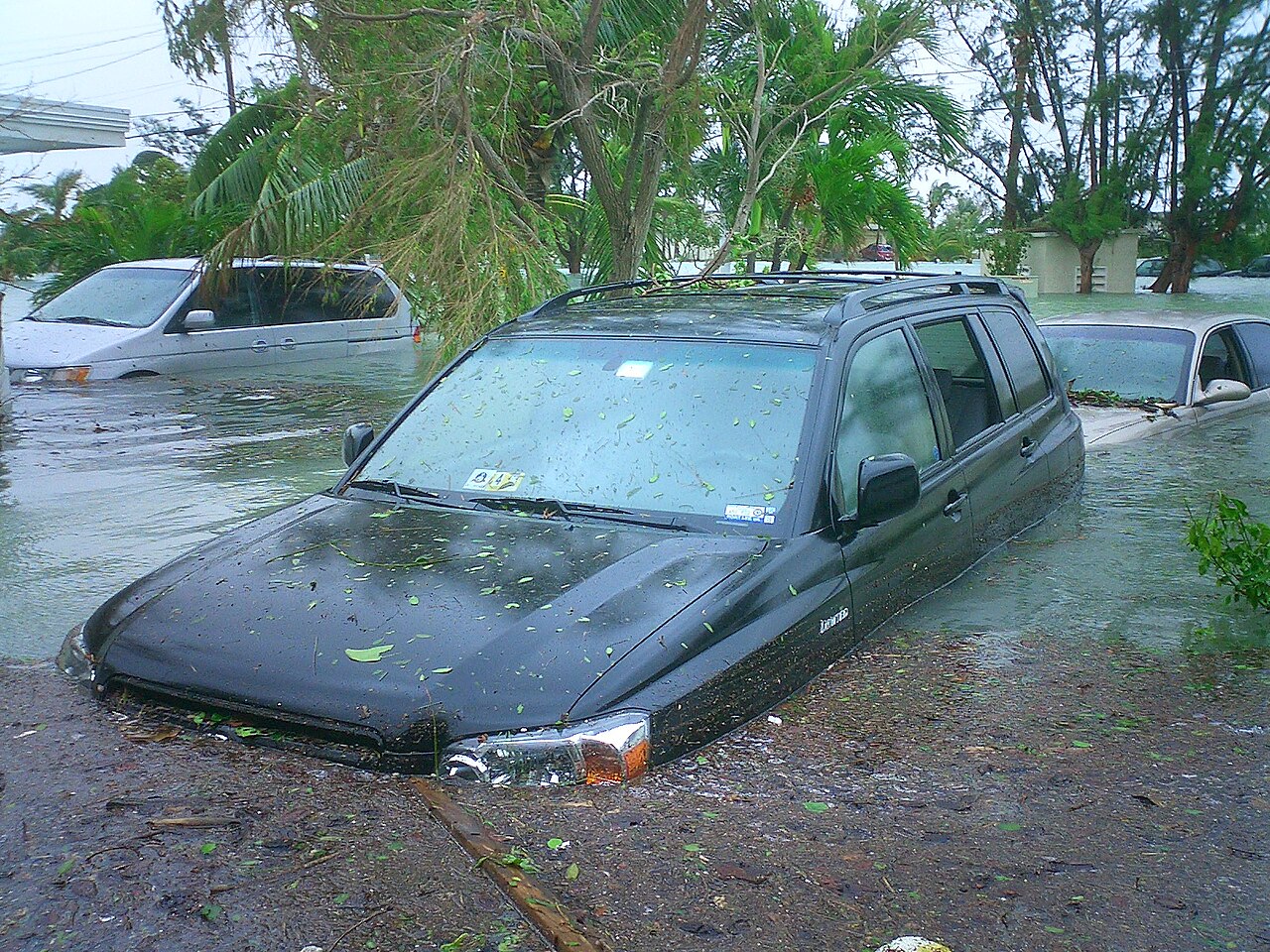
In 2017, Hurricane Irma caused substantial damage with wind and flooding, killing three people.
Geography
Key West is an island located at 24°33′55″N 81°46′33″W in the Straits of Florida. The island is about 4 miles (6 km) long and 1 mile (2 km) wide, with a total land area of 4.2 square miles (10.9 km2; 2,688.0 acres). The average elevation above sea level is about 8 feet (2.4 m) and the maximum elevation is about 18 feet (5.5 m), within a 1-acre (0-hectare) area known as Solares Hill.
The city of Key West is the southernmost city in the contiguous United States, and the island is the westernmost island connected by highway in the Florida Keys. The city boundaries include the island of Key West and several nearby islands, as well as the section of Stock Island north of U.S. Route 1, on the adjacent key to the east. The total land area of the city is 5.6 square miles (15 km2), with an additional 1.6 square miles (4.1 km2) of surrounding water within the city limits. Sigsbee Park—originally known as Dredgers Key—and Fleming Key, both located to the north, and Sunset Key located to the west are all included in the city boundaries. Both Fleming Key and Sigsbee Park are part of Naval Air Station Key West and are inaccessible to the general public.
In the late 1950s, many of the large salt ponds on the eastern side of the island were filled in. The new section on the eastern side is called New Town, which contains shopping centers, retail malls, residential areas, schools, ball parks, and Key West International Airport.
Key West and most of the rest of the Florida Keys are on the dividing line between the Atlantic Ocean and the Gulf of Mexico. The two bodies have different currents, with the calmer and warmer Gulf of Mexico being characterized by great clumps of seagrass. The shallow passage known as Hawk Channel lies directly south of the island and is conducive to the exchange of Gulf waters to the Atlantic via tidal currents. The area where the two bodies merge between Key West and Cuba is called the Straits of Florida. The warmest ocean waters anywhere on the United States mainland are found in the Florida Keys in winter, with sea surface temperatures averaging in the 75–77 °F (24–25 °C) range in December through February.
Duval Street is the main street in Key West and is 1.1 miles (1.8 km) in length in its 14-block-long crossing from the Gulf of Mexico to the Straits of Florida and the Atlantic Ocean.
Key West is closer to Havana (about 106 miles or 171 kilometers by air or sea) than it is to Miami (130 miles or 210 kilometers by air or 165 miles or 266 kilometers by road). Key West is the usual endpoint for marathon swims from Cuba, including Diana Nyad's 2013 swim and Susie Maroney's 1997 swim from within a shark cage.
Notable places
Old Town
The earliest Key West neighborhoods, on the western part of the island, are broadly known as Old Town. The Key West Historic District includes the major tourist destinations of the island, including Mallory Square, Duval Street, the Truman Annex, and Fort Zachary Taylor. Old Town is where the classic bungalows and guest mansions are found. Bahama Village, southwest of Whitehead Street, features houses, churches, and sites related to its Afro-Bahamian history. The Meadows, lying northeast of the White Street Gallery District, is exclusively residential.
Many of the structures in Old Town date from 1886 to 1912. The basic features that distinguish the local architecture include wood-frame construction of one- to two-and-a-half-story structures set on foundation piers about three feet (one meter) above the ground. Exterior characteristics of the buildings are peaked metal roofs, horizontal wood siding, gingerbread trim, pastel shades of paint, side-hinged louvered shutters, covered porches (or balconies, galleries, or verandas) along the fronts of the structures, and wood lattice screens covering the area elevated by the piers.
Some antebellum structures survive, including the Oldest (or Cussans-Watlington) House (1829–1836) and the John Huling Geiger House (1846–1849), now preserved as the Audubon House and Tropical Gardens. Fortifications such as Fort Zachary Taylor, the East Martello Tower, and the West Martello Tower, helped ensure that Key West would remain in Union control throughout the Civil War. Another landmark built by the federal government is the Key West Lighthouse, now a museum.
Two of the most notable buildings in Old Town, occupied by prominent 20th-century residents, are the Ernest Hemingway House, where the writer lived from 1931 to 1939, and the Harry S. Truman Little White House, where the president spent 175 days of his time in office. Additionally, the residences of some historical Key West families are recognized on the National Register of Historic Places as important landmarks of history and culture, including the Porter House on Caroline Street and the Gato House on Virginia Street.
Several historical residences of the Curry family remain extant, including the Benjamin Curry House, built by the brother of Florida's first millionaire, William Curry, as well as the Southernmost House and the Fogarty Mansion, built by the children of William Curry—his daughter Florida and son Charles, respectively.
In addition to architecture, Old Town includes the Key West Cemetery, founded in 1847, containing above-ground tombs, notable epitaphs, and a plot where some of the dead from the 1898 explosion of USS Maine are buried.
Casa Marina
The Casa Marina area takes its name from the Casa Marina Hotel, opened in 1921, the neighborhood's most conspicuous landmark. The Reynolds Street Pier, Higgs Beach, the West Martello Tower, the White Street Pier, and Rest Beach line the waterfront.
Southernmost point in the United States
One of the most popular attractions on the island is a concrete replica of a buoy at the corner of South and Whitehead Streets that claims to be the southernmost point in the contiguous United States. The point was originally marked with a basic sign. The city of Key West erected the current monument in 1983. The monument was repainted after damage by Hurricane Irma in 2017, and is the most often photographed tourist site in the Florida Keys.
Although the monument is labeled "Southernmost point continental U.S.A.", the actual southernmost point of Key West is Whitehead Spit, which is on the Truman Annex property just west of the buoy. The spit has no marker since it is on U.S. Navy land that cannot be entered by civilian tourists. The private property directly to the east of the buoy, and the beach areas of Truman Annex and Fort Zachary Taylor Historic State Park, also lie farther south than the buoy. The southernmost point of the contiguous United States is Ballast Key, a privately owned island just south and west of Key West. The southernmost location that the public can visit is the beach at Fort Zachary Taylor park.
The monument states "90 Miles to Cuba", although Key West and Cuba are actually about 95 statute miles (153 kilometers; 83 nautical miles) apart at their closest points. Note that the distance from the monument to Havana is, however, about 90 nautical miles (104 statute miles; 167 kilometers).
Key West Library
The first public library was officially established in 1853, which was housed in the then-Masonic Temple on Simonston Street, near where the federal courthouse is today. At the time, the first library president was James Lock, with the librarian being William Delaney. At the time, the library collected held 1,200 volumes for residents to access.
In 1919, a hurricane destroyed the library. Key West residents moved the library to various locations across the island. The county took over and finally found a permanent location. The library's new location was found in 1959. It was built on Fleming Street, where it is still found today.