
Hut Point Peninsula (77°47′S 166°51′E) is a long, narrow peninsula from 2 to 3 nautical miles (3.7 to 5.6 km; 2.3 to 3.5 mi) wide and 15 nautical miles (28 km; 17 mi) long, projecting south-west from the slopes of Mount Erebus on Ross Island, Antarctica.
McMurdo Station (US) and Scott Base (NZ) are Antarctic research stations located on the Hut Point Peninsula.
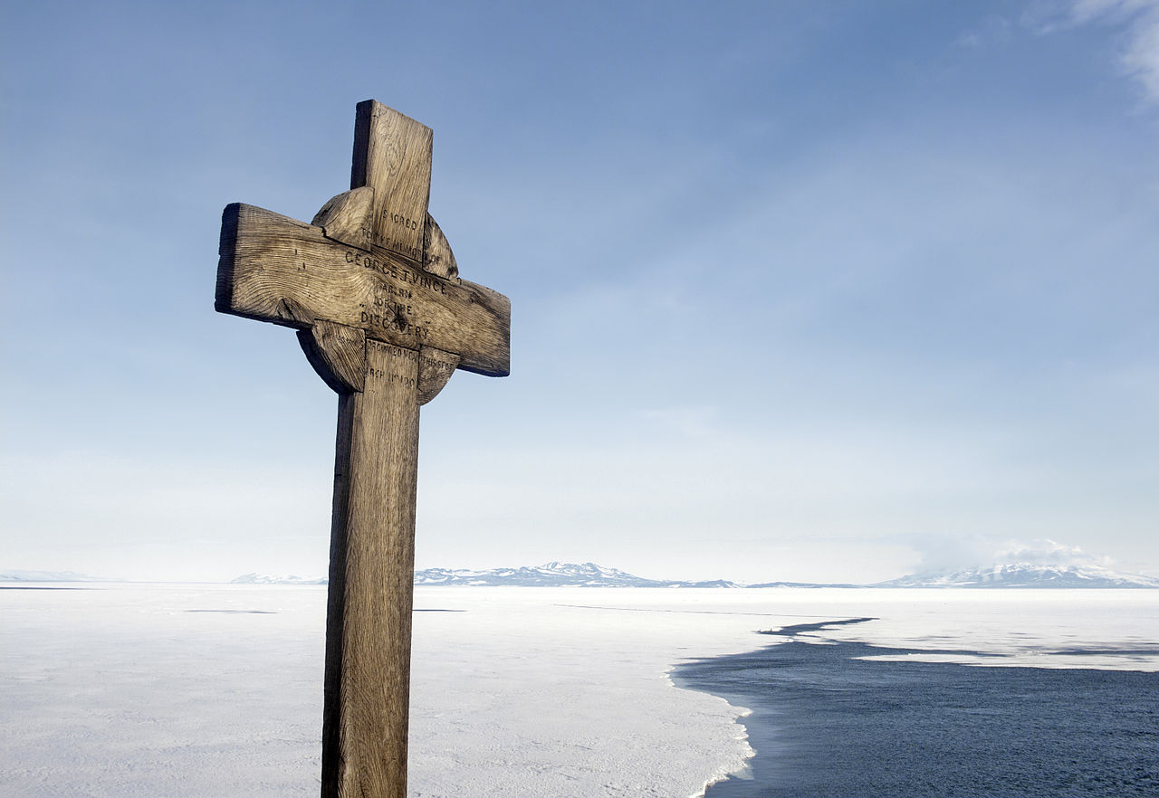
It is also home to historical sites including the Discovery Hut from Robert Falcon Scott's 1901 expedition, and memorials of various types. Hut Point Peninsula is the most inhabited place on Antarctica since the 1950s and is continuously occupied.

History
The British National Antarctic Expedition (1901–04) under Robert Falcon Scott built its Discovery Hut on Hut Point, at the southern headland of the peninsula.
Members of the British Antarctic Expedition, 1910–13 (BAE), under Scott, wintering on Cape Evans and often using the hut during their journeys, came to refer to the whole peninsula as the Hut Point Peninsula.
Historic sites and monuments
Several features on Hut Point, including the cross memorial for George Vince and the store hut for the Scott expeditions, are protected under the Antarctic Treaty.

Both the cross (HSM 19) and the hut (HSM 18) have been designated Historic Sites or Monuments, following proposals by New Zealand and the United Kingdom to the Antarctic Treaty Consultative Meeting. The point is protected as Antarctic Specially Protected Area No.158 largely because of its historic significance as one of the principal sites of early human activity in Antarctica.
Features
Hut Point Peninsula consists of a series of basaltic scoria cones, craters and domes that were formed in the last 1.34 million years.
Other features around the Hut Point Peninsula include Sultans Head Rock, Descent Cliff, Hutton Cliffs, Turtle Rock, Knob Point, Danger Slopes, Arrival Heights, Crater Hill, Hut Point, Cape Armitage, Observation Hill, The Gap and Pram Point.

Craters
First Crater
77°50′S 166°39′E.
A crater on Arrival Heights, located 0.75 nautical miles (1.39 km; 0.86 mi) north of Hut Point.
Named by Debenham in 1912 on his local survey of Hut Point Peninsula during the British Antarctic Expedition, 1910-13.
Second Crater
77°49′S 166°40′E.
A crater on Arrival Heights, situated 0.6 nautical miles (1.1 km; 0.69 mi) northeast of First Crater.
Named by F. Debenham in 1912 on his local survey of Hut Point Peninsula during the British Antarctic Expedition, 1910-13.

Sheppard Crater
77.805347°S 166.841572°E / -77.805347; 166.841572.
A distinctive breached crater rising to 200 metres (660 ft) high about 0.8 nautical miles (1.5 km; 0.92 mi) east of Castle Rock.
Named in 2000 by New Zealand Geographic Board (NZGB) after Deirdre Jeanette Sheppard, DSIR Antarctic Division/NZAP/Antarctica NZ librarian, 1980-96, who worked one season at Vanda Station.

Half Moon Crater
77.807744°S 166.747093°E / -77.807744; 166.747093.
A crater 0.5 nautical miles (0.93 km; 0.58 mi) southwest of Castle Rock.
Descriptively named for its shape by Frank Debenham of British Antarctic Expedition (British Antarctic Expedition), 1910-13, who made a plane table survey of the peninsula in 1912.
Twin Crater
77.840604°S 166.686128°E / -77.840604; 166.686128.
A crater with twin nested cones that rises behind McMurdo Station and 0.5 nautical miles (0.93 km; 0.58 mi) west of Crater Hill.
This crater was named Middle Crater by Frank Debenham of the British Antarctic Expedition (British Antarctic Expedition), 1910-13, apparently for its location in relation to First Crater and Crater Hill, but the name has fallen into disuse.
Twin Crater, alluding to the nested cones in the crater, was applied as early as 1971 and the name has become established because of consistent use in current maps and reports.
Northern features
Features in the north of the peninsula, from north to south, include
Centipede Nunatak
77.747205°S 166.892322°E / -77.747205; 166.892322.
A narrow nunatak that is 0.3 nautical miles (0.56 km; 0.35 mi) long, located 0.8 nautical miles (1.5 km; 0.92 mi) north-northwest of Ford Rock in central Hut Point Peninsula.
The name is allusive; snow that cuts across parts of the nunatak gives it a segmented appearance resembling that of a centipede.
Named by the Advisory Committee on Antarctic Names (US-ACAN), 2000.
Rodgers Point
77.767734°S 166.783895°E / -77.767734; 166.783895.
A point 2.5 nautical miles (4.6 km; 2.9 mi) northeast of Knob Point on the west side of Hut Point Peninsula.
Named by New Zealand Geographic Board (NZGB) (2000) after Thelma Rodgers, scientific officer, who was the first woman to winter-over at Scott Base, 1979.
Ford Rock
77°46′S 166°53′E.
A prominent rock 1 nautical mile (1.9 km; 1.2 mi) northeast of Cone Hill.
Cone Hill and this rock were designated "Cone Hill I" and "Cone Hill II," respectively, by the British Antarctic Expedition under Scott, 1910-13.
Cone Hill has been approved for Scott's "Cone Hill I," but a new name suggested by A.J. Heine has been substituted for this prominent rock.
M.R.J. Ford, New Zealand surveyor, established a survey beacon network for the McMurdo Ice Shelf Project, 1962-63.
A survey beacon was established earlier on this rock by a United States Hydrographic Office survey team, 1955-56.
Cone Hill
77°47′S 166°51′E.
A hill 2 nautical miles (3.7 km; 2.3 mi) northeast of Castle Rock.
The descriptive name "Cone Hill I" was used by the British Antarctic Expedition under Robert Falcon Scott, 1910-13, but the form Cone Hill has come into general use.
Ackley Point
77.789466°S 166.920391°E / -77.789466; 166.920391.
An ice-covered point 1 nautical mile (1.9 km; 1.2 mi) southeast of Cone Hill on the east side of Hut Point Peninsula.
Named by the Advisory Committee on Antarctic Names (US-ACAN) in 2000 after Stephen F. Ackley, Snow and Ice Division, U.S. Army Cold Regions Research and Engineering Laboratory (CRREL), Hanover, New Hampshire, a U.S. Antarctic Project (USAP) sea ice specialist who worked in McMurdo Sod and diverse parts of the Southern Ocean for more than 25 years, dating from the 1976-77 austral season.