County Meath ( MEEDH; Irish: Contae na Mí or simply an Mhí, lit. 'middle') is a county in the Eastern and Midland Region of Ireland, within the province of Leinster. It is bordered by County Dublin to the southeast, Louth to the northeast, Kildare to the south, Offaly to the southwest, Westmeath to the west, Cavan to the northwest, and Monaghan to the north. To the east, Meath also borders the Irish Sea along a narrow strip between the rivers Boyne and Delvin, giving it the second shortest coastline of any county. Meath County Council is the local authority for the county.
Meath is the 14th-largest of Ireland's 32 traditional counties by land area, and the 8th-most populous, with a total population of 220,826 according to the 2022 census. The county town and largest settlement in Meath is Navan, located in the centre of the county along the River Boyne. Other towns in the county include Trim, Kells, Laytown, Ashbourne, Dunboyne, Slane and Bettystown.
Colloquially known as "The Royal County", the historic Kingdom of Meath was the seat of the High King of Ireland and, for a time, was also the island's fifth province. Ruled for centuries by the Southern Uí Néill dynasty, in the late 1100s the kingdom was invaded by the Anglo-Norman conqueror Hugh de Lacy, who ousted the Uí Néill and established himself as the Lord of Meath. This lordship gradually diminished in size before being formally shired as County Meath in 1297, which was further sub-divided into Meath and Westmeath in 1542. The county took its present boundaries in 1977, when much of Drogheda was transferred to County Louth.
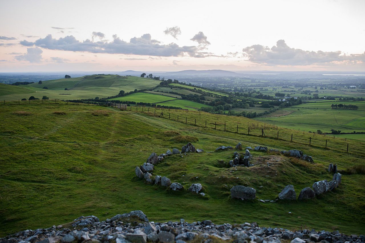
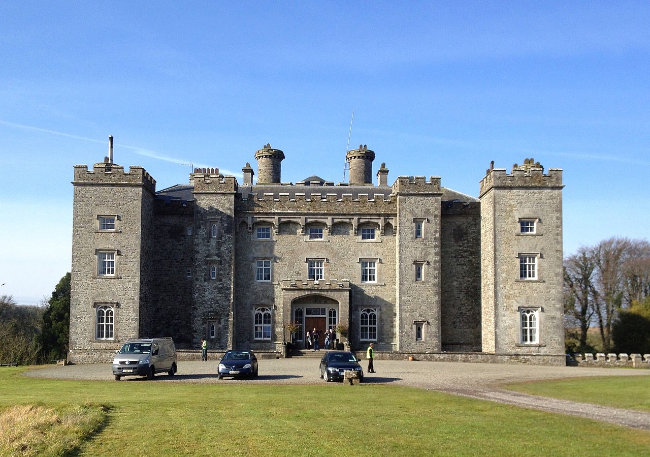
Meath has an abundance of historical sites, including the Hill of Tara, Hill of Slane, Newgrange, Knowth, Dowth, Loughcrew, the Abbey of Kells, Trim Castle and Slane Castle. The county was also the site of the seminal Battle of the Boyne, which was fought near Oldbridge in 1690, ending in the defeat of James II and his flight to France. It is the only county in Leinster to have Gaeltacht regions, at Ráth Chairn and Baile Ghib, and is also one of only two counties outside of the west of Ireland to have an official Gaeltacht (the other being County Waterford).
Geography and subdivisions
Meath is the 14th-largest of Ireland's 32 counties by area, and the eighth-largest in terms of population. It is the second-largest of Leinster's 12 counties in size, and the third-largest in terms of population. Meath borders seven counties – Dublin and Louth to the east, Westmeath and Offaly to the west, Kildare to the south, and Cavan and Monaghan to the north. Meath's coastline stretches for roughly 20 km (12 mi) along the Irish Sea between the Boyne and Delvin rivers, making it the second shortest coastline of any coastal county. The county town, Navan, is the largest settlement in Meath, and is situated on the River Boyne in the middle of the county. Navan is approximately 50 km (31 mi) from Dublin and 140 km (87 mi) from Belfast.
Physical geography
Owing to the fertile agricultural plains along the Boyne valley, which dominate the county, Meath's landscape is largely rural in nature. However, it is also one of the most densely populated counties in Ireland, with a population density of 94 people per km2. Centuries of exhaustive harvesting and reclamation for agriculture have severely reduced the extent of bogland in the county, especially in comparison to the neighbouring Midland counties. However, small areas of bogland survived, such as Jamestown Bog, Girley Bog and Killyconny Bog, and are currently protected as either Special Areas of Conservation (SACs) or Natural Heritage Areas (NHAs).
The River Boyne, at 112 km (70 mi) in length, is Meath's dominant geographic feature and is synonymous with the county, having defined its history and culture over millennia. The two most prominent tributaries of the Boyne are the Leinster Blackwater, which has its source in Cavan and flows south for 68 km (42 mi) before joining the Boyne at Navan, and the Enfield Blackwater, which has its source in Kildare and flows north for 25 km (16 mi) before joining the Boyne at Donore. In the east of the county, both the River Nanny and the Delvin River flow to the Irish sea, with the latter demarcating the border with County Dublin.
As of 2017, there is a total of 13,326 ha (32,929 acres) of forest cover in the county, representing 5.7% of the total land area. This is an increase from just 11,200 ha (27,676 acres) (4.8%) in 2006. Nevertheless, Meath is Ireland's third-least forested county and remains well below the national average of 11% forest cover. Historically, Meath was extensively forested, but experienced a near total deforestation between the 16th and 18th centuries. Although it has rebounded in recent years, the low forest cover compared to other counties can be explained by the lack of a significant commercial forestry industry within the county. Meath is one of the smallest contributors to the national timber supply, and over two-thirds of Meath's forests are broadleaf – the highest of any county – as opposed to more commercially viable conifers. Additionally, three-quarters of forests within the county are privately owned.
Climate
Under Köppen climate classification, Meath experiences a maritime temperate oceanic climate with cool winters, mild humid summers, and a lack of temperature extremes. Met Éireann records the climate data for Meath from their station at Dunsany, situated 83 m (272 ft) above sea level. The average maximum January temperature is 7.3 °C (45 °F), while the average maximum July temperature is 19.6 °C (67 °F). On average, the sunniest months are May and June, while the wettest month is October with 87 mm (3 in) of rain, and the driest month is June with 67 mm (3 in). Humidity is high year-round and rainfall is evenly distributed throughout the year. A number of synoptic stations which record rainfall are located throughout the county. The driest parts of the county are in the east and south, while the wettest are in the west. Julianstown near the east coast receives 781 mm (31 in) of rainfall per year, while Oldcastle in the west receives 1,002 mm (39 in). The annual precipitation at Dunsany is 847 mm (33 in).

Snow showers generally occur between November and March, but prolonged or heavy snow events are rare. Although frost is common in the central and western areas of the county, temperatures typically fall below 0 °C (32 °F) on just a few days per year. The lowest ever temperature in Meath was recorded in December 2010, at −13.3 °C (8 °F). Summer daytime temperatures range between 15 °C (59 °F) and 22 °C (72 °F), with temperatures rarely going beyond 25 °C (77 °F). As with rainfall, the sunniest areas of the county are located along the coast. The climate gets progressively duller and wetter inland due to the convective development of clouds over land.
Geology
The county's geological landscape is predominantly made up of Lower Carboniferous limestone, which underlies approximately 75% of the county. These were laid down following the erosion of mountain ranges which formed due to the closure of the Iapetus Ocean. The eroded mountains became basins in which limestone sediments and carbonate mud were deposited. The oldest rocks in the county are Ordovician in age and are found in thin layers near Slane and at Stamullen, while the youngest rocks are of Paleogene age, and were formed as a result of volcanic activity. These are found in small dykes and sills throughout the county. Crustal stretching beneath Ireland during the Carboniferous allowed fluids to infiltrate through faults in the rock, and extensive mineralisation occurred. Most notably, zinc-bearing Sphalerite and lead-bearing Galena were deposited in vast quantities, giving Ireland the highest concentration of zinc per square kilometre on Earth. The ubiquity of these minerals gave rise to the term "Irish-type" lead-zinc deposits, which is a descriptive term for lead-zinc deposits hosted in carbonate rocks.
Meath's landscape was shaped during the Last Glacial Period, which ended 11,700 years ago. The soils of the county are mostly derived from glacial till, consisting of a mix of clay, sand and gravel which were deposited by glacial melt-water. In the north of the county near the border with Cavan, a small series of drumlins were formed from boulder clay. Loughs typically form in between the poorly-drained inter-drumlin areas, however unlike in neighbouring Cavan and Westmeath, Meath has no sizable loughs, other than Lough Sheelin, on which the county shares a small coastline in its westernmost tip.

Meath is largely flat and much of the county lies below 100 m (330 ft) above sea-level. The minor hills in the far west of the county at Loughcrew, and in the north at Carrickleck are the only upland areas of any significance. Slieve na Calliagh, at just 276 m (906 ft) in height, is the highest point in the county, making it the second lowest county top in Ireland. Carrickleck Hill, near the Cavan border, is the second highest peak in Meath, at 173 m (568 ft). The Hill of Tara is located south of Navan and, although just 155 m (509 ft) in height, is the most prominent feature in the local topography, commanding a panoramic view of the surrounding area.
Baronies
There are eighteen historic baronies in the county. While baronies continue to be officially defined units, they are no longer used for many administrative purposes, and the barony boundaries in County Meath which continuously changed from the 16th to 19th centuries were last finalised in 1807. Their official status is illustrated by Placenames Orders made since 2003, where official Irish names of baronies are listed under "Administrative units". The largest barony in Meath is Kells Upper, at 49,552 acres (201 km2), and the smallest barony is Dunboyne, at 16,781 acres (68 km2).
Civil parishes and townlands
Townlands are the smallest officially defined geographical divisions in Ireland, there are approximately 1,634 townlands in the county. Historic town boundaries are registered as their own townlands and much larger than rural townlands which, within County Meath, are typically small in size, ranging from just 1 acre to 2,681 acres, with the average size of a townland in the county (excluding towns) being 356 acres.

Towns and villages
European statistical region
For statistical purposes at EU level, the county is part of the Mid-East Region – a NUTS III entity – which is in turn part of the level II NUTS entity – Eastern and Midland Region.
Governance and politics
Local government
Meath County Council is the local authority governing County Meath. It has 40 councillors, and the county is divided into divided into six local electoral areas, each of which also forms a municipal district: Ashbourne (6), Kells (7), Laytown–Bettystown (7), Navan (7), Ratoath (7) and Trim (6).
Fine Gael currently hold 11 seats, Fianna Fáil hold 9, Sinn Féin hold 6, Aontú hold 2, and the Social Democrats hold 1. There are 11 independent councillors. Council elections are held every 5 years, with the next election due to be held in June 2029. The 2024 Meath local elections had a voter turnout of 48.0%, a very slight decrease of 0.1% on the 2019 election. The highest turnout was at Kells (55.0%) and the lowest was at Trim (43.9%).

The council has three representatives on the Eastern and Midland Regional Assembly.
The county town is Navan, where the county hall and government are located, although Trim, the former county town, has historical significance and remains a sitting place of the circuit court.
Former districts
County Meath was divided under the Local Government (Ireland) Act 1898 into the rural districts of Ardee No. 2, Dunshaughlin, Kells, Meath, Navan, Oldcastle, Trim, and Edenderry No. 3, and the urban districts of An Uaimh (Navan), Ceannanus Mór (Kells), and Trim. The rural districts were abolished in 1925. The urban districts became town councils in 2002. All town councils in Ireland were abolished in 2014.
National elections
County Meath is within two Dáil constituencies:
Meath East – lies entirely within the borders of the county;
Meath West – comprises the western portion of the county.
From 1923 to 1937, and again from 1948 to 2007, there was one Meath constituency. From 1937 to 1948 the county was within the Meath–Westmeath constituency. Between 1923 and 2007 a total of 31 general elections and by-elections were held. Following the demise of Cumann na nGaedheal in the 1930s, national politics in the Meath and Meath–Westmeath constituencies was dominated by Fianna Fáil, Fine Gael and Labour Party. During those years, the Meath and Meath–Westmeath constituencies returned a total of 106 TDs to Dáil Éireann, of which 54 were from Fianna Fáil, 34 from Fine Gael and 11 from Labour; with Cumann na nGaedheal and the Farmers' Party returning 6 and 1 TDs respectively in the 1920s and 1930s. No other party would win a Dáil seat in Meath until 2011, when Peadar Tóibín was elected to Meath West for Sinn Féin.
Meath East and Meath West return seven TDs to the Dáil. In the most recent general election in 2024, Sinn Féin won two, Fianna Fáil won two and Fine Gael, Aontú and an independent won one seat each.
European elections
The county is part of the five seat Midlands–North-West constituency for elections to the European Parliament.
History
The county is colloquially known by the nickname "The Royal County", owing to its history as the seat of the High King of Ireland. It formed from the eastern part of the former Kingdom of Mide but now forms part of the province of Leinster. Historically, the kingdom and its successor territory the Lordship of Meath included all of the counties Meath, Fingal and Westmeath as well as parts of counties Cavan, Longford, Louth, Offaly and Kildare. The seat of the High King of Ireland was at Tara. The archaeological complex of Brú na Bóinne in the north-east of the county is 5,000 years old and is a UNESCO-designated World Heritage Site.
Pre-history
The earliest known evidence of human settlement in the county is the Mesolithic flints found at Randalstown north of Navan, which were uncovered during the construction of the tailings pond for Tara Mines in the 1970s. These flints have been dated to 9,500 BC and are one of the earliest traces of pre-historic humans in Ireland. The excavation site at Randalstown also revealed other evidence of hunter-gatherer society, such as a fulacht fiadh and mounds of burnt soil and stone.
Farming was established in the area during the Neolithic period. This provided a surplus of time and resources which was spent constructing great stone monuments to the dead, such as passage graves, court cairns and wedge tombs. There are hundreds of surviving examples of these dotted across the landscape, however, the most famous Neolithic monuments in Ireland are those at Brú na Bóinne – Newgrange, Knowth and Dowth. These tombs were constructed prior to 3,000 BC making them older than Stonehenge and the Egyptian pyramids. The site is believed to have been of religious significance and is decorated with megalithic art. Newgrange, the largest pre-historic tomb in Ireland, is most famous for its alignment with the equinoxes, when sunlight shines through a 'roofbox' and floods the inner chamber. In constructing the tomb the early settlers displayed an advanced knowledge of astronomy and a calendar system. However, a writing system would not be developed until the 1st century BC, with the emergence of Ogham.
The arrival of the Celts to Ireland around 500 BC heralded the beginning of the Iron Age and the establishment of most of what would define Gaelic Irish culture for millennia; including Primitive Irish, Irish mythology, Celtic paganism and an early form of the Gaelic calendar. The ancient monuments of the Boyne Valley were assimilated into Celtic culture and mythology, with Cú Chulainn said to have been conceived at Newgrange. Furthermore, tradition states that Sláine mac Dela, of the Fir Bolg, cleared the forest at Brú na Bóinne and built the monuments, becoming the first High King of Ireland. It was during the Celtic period that Meath was divided into 8 túatha, the primary political unit of Celtic Ireland. The túatha were independent petty kingdoms ruled by a chief who was elected by members of their extended family.
Early Christian period (400–1169)
Kingdom of Meath
Due to a lack of extensive written historical records prior to the 5th century AD, the early history of Meath is murky and largely mythologised. Irish legend purports that the title of "High King of Ireland" stretches back millennia, however, it is today known that the Hill of Tara did not become a seat of power until the early centuries AD. In the 400s, Niall of the Nine Hostages, King of the Uí Néill, conquered southward from Ulster and established a kingdom in Meath. As was commonplace in Ireland at the time, the achievements of Niall and his sons were propagandised and mythicised by bards to such an extent that much of what is known about them is considered fictional. Nevertheless, the dynasty of the Uí Néill had become firmly established in the centre of Ireland and they proclaimed themselves the Kings of Tara and Kings of Uisnech. The Uí Néill dynasty subsequently divided into two septs, the Northern Uí Néill who remained in Ulster, and the Southern Uí Néill who now ruled over several small, disjointed kingdoms established throughout modern-day Meath, Westmeath and Dublin.
Following the split, a series of internecine conflicts erupted between members of the Uí Néill septs. The feud was eventually resolved, and as part of the resolution, it was decided that the position of King of Tara would alternate between the northern and southern Uí Néill septs. The title alternated between the two septs for over 500 years, with every second king travelling south from Ulster for an inauguration ceremony at Tara. By 740, Domnall Midi of the Clann Cholmáin dynasty, the most powerful branch of the southern Uí Néill, had conquered or subdued all neighbouring clans in Meath, and the Uí Néill were recognised as their suzerain. Domnall was now in possession of both Tara, the seat of the Uí Néill, and the Hill of Uisneach, which held symbolic significance as the geographical centre of Ireland. Having secured his power in the heart of the island, Domnall now presided over a unified Kingdom of Mide (Meath), a name derived from the Old Irish meaning "middle".
The first annalistic mention of a "High King of Ireland" or "Ard-Rí" was Máel Sechnaill mac Máele Ruanaid, King of Mide, who died in 862 AD, having achieved many victories against both the Norse and the kingdoms of Ulster. Later historians would retroactively apply the title of "High King" to the earlier Kings of Tara, although there were no contemporary references to either the Kings of Tara or Mide being referred to as Ard-Rí prior to the 9th century. During the reign of Máel Sechnaill mac Domnaill in the 970s, the fort of Dun-na-Scia near Lough Ennell became the permanent royal residence, thereby creating two seats of power within the kingdom – one for the High King and one for the King of Mide.
In the late 10th century, the Dalcassians to the south, led by Brian Boru, consolidated their hold over Munster, with Boru establishing himself as King of Munster. The ascendancy of this longtime rival kingdom posed a serious threat to High King Máel Sechnaill mac Domnaill, so the two leaders met at Clonfert in 997 and agreed upon a truce, whereby Boru was granted overlordship of the southern half of the island. The Kingdom of Leinster immediately rebelled against Boru and allied with the Norse Kingdom of Dublin. Mide and Munster formed a defensive alliance and, after a series of campaigns throughout 998–999, crushed the forces of Leinster and Dublin, which both became vassals of Munster.
Boru now believed that Munster was the most powerful kingdom in Ireland and therefore he, and not Máel Sechnaill, should be the High King. Máel Sechnaill's claim to the kingship was challenged by Boru in 1002 at the Hill of Tara. The Meath king requested a month-long truce to rally his subordinates to his side, which Boru accepted, however, Máel Sechnaill was quickly abandoned by his northern Uí Néill kinsmen. Having failed to raise enough troops to challenge Boru, he was forced to abdicate, thus ending the hereditary right of the Uí Néill to the title of High King. Although they remained Kings of Meath, the power and prestige of the southern Uí Néill would never recover.
Monastic settlement
Traditional accounts of the arrival of Saint Patrick and Christianity to Ireland are centred on Meath and its legendary High Kings. Folklore states that he travelled to the kingdom to light a Paschal Fire on the Hill of Slane, in defiance of High-King Lóegaire mac Néill, who was on the nearby Hill of Tara celebrating a pagan festival. Patrick was then summoned to the king's court and so impressed Lóegaire with his teachings that he was allowed to continue preaching Christianity across Ireland. While Christian missionaries were documented in Ireland long before the time of Saint Patrick, and accounts of his activities are heavily shrouded in myth, what is known is that by the late 6th century AD Christianity had supplanted Celtic Paganism in every corner of the island. In a similar manner to how the Celts assimilated prehistoric traditions into their beliefs, many Celtic pagan beliefs and festivities were adapted to Celtic Christianity, such as Samhain, which became Halloween, and Imbolc, which became St. Brigid's Day.
By the 7th century a network of monasteries and religious settlements had been set up throughout Ireland and Western Scotland, supported by local kings and chieftains. Beginning at this time, the "Golden Age of Irish Christianity" lasted for several centuries. Irish Scholars preserved invaluable Latin texts and Gaelic monasteries developed into centres of learning which attracted theologians from across Europe. These monasteries sent missionaries to northern and central Europe to re-ignite Christianity and Latin tradition in areas where it had lapsed following the fall of the Western Roman Empire. One of Ireland's national nicknames, "the land of saints and scholars", is in reference to this period.
Patronage of the Church was also used as a political tool to project wealth and prestige in Irish kingdoms until the 16th century. Successive High Kings and Kings of Meath supported the establishment of prominent religious settlements and institutions, such as Kells and Clonard Abbey, the latter of which taught Ireland's most significant saints, dubbed the Twelve Apostles of Ireland. During the golden age, the monasteries of Meath were associated with several of Ireland's most famous artefacts, which are considered to be among the finest examples of Insular and medieval Christian art in existence.
As knowledge of the importance and wealth of the Irish monasteries became more widely known, they began to attract the attention of Vikings, who were raiding throughout Britain and Ireland in the 8th century. The most distinctive feature of Irish monasteries, their round towers, were built in response to these Viking raids. Eventually, the Vikings established kingdoms and founded Ireland's first cities along coastal areas, including in neighbouring Dublin. The High Kings and lesser kingdoms waged near-continuous war with these Norse-Gael settlers for over two centuries.
Lordship of Ireland (1169–1542)
Norman period
In 1166, Diarmait Mac Murchada was banished from Ireland by the High King Ruaidrí Ua Conchobair for the abduction of Lady of Meath Derbforgaill ingen Maeleachlainn, wife of Tigernán Ua Ruairc, King of Breifne. Mac Murchada returned with Norman allies and landed at Bannow in Wexford in 1169, after which they conquered northward throughout 1169–70, initiating the Norman Invasion of Ireland. In response, the High King assembled an alliance which included King Magnus Ua Máel Sechlainn of Meath as well as soldiers from Connacht, Breifne and Dublin along with their respective kings. They confronted Mac Murchada's forces at Ferns and an agreement was reached whereby Mac Murchada was acknowledged as king of Leinster, in return for acknowledging Ruaidrí as his overlord and agreeing to send his foreign allies away permanently. However, Mac Murchada breached the agreement and enlisted more Normans to his side before continuing his conquests, capturing Dublin in 1171 and forcing the capitulation of Magnus Ua Máel Sechlainn.