
The Chicago "L" (short for "elevated") is the rapid transit system serving the city of Chicago and some of its surrounding suburbs in the U.S. state of Illinois. Operated by the Chicago Transit Authority (CTA), it is the fourth-largest rapid transit system in the United States in terms of total route length, at 102.8 miles (165.4 km), as of 2014, and the third-busiest rapid transit system in the United States after the New York City Subway and the Washington Metro. As of January 2024, the "L" had 1,480 rail cars operating across eight different routes on 224.1 miles of track. CTA trains make about 1,888 trips each day servicing 146 train stations. In 2025, the system had 135,202,800 rides, or about 385,500 per weekday in the first quarter of 2026.
The "L" provides 24-hour service on the Red and Blue Lines, making Chicago, New York City, London and Copenhagen the only four cities in the world to offer 24-hour train service on some of their lines throughout their respective city limits. The Orange Line has planned 24-hour service beginning in 2026. The oldest sections of the Chicago "L" started operations in 1892, making it the second-oldest rapid transit system in the Americas, after New York City's elevated lines. The "L" gained its name from "el" because most parts of the system run on elevated track, although portions of the network are in subway tunnels, at grade level, or in open cuts.
The "L" has been credited for fostering the growth of Chicago's dense city core that is one of the city's distinguishing features. And according to urban engineer Christof Speiler, the system stands out in the United States because it continued to invest in services even through the post-World-War era growth of the expressway; its general use of alleyways instead of streets throughout its history, and expressway medians after the war, better knit the system into the city, and in pioneering ways. It consists of eight rapid transit lines laid out in a spoke–hub distribution paradigm focusing transit toward the Loop.
In a 2005 poll, Chicago Tribune readers voted it one of the "seven wonders of Chicago", behind the lakefront and Wrigley Field, and ahead of Willis Tower (formerly the Sears Tower), the Water Tower, the University of Chicago, and the Museum of Science and Industry.
History
Pre-CTA era
The first "L", the Chicago and South Side Rapid Transit Railroad, began revenue service on June 6, 1892, when a steam locomotive pulling four wooden coaches, carrying more than a couple of dozen people, departed the 39th Street station and arrived at the Congress Street Terminal 14 minutes later, over tracks that are still in use by the Green Line. Over the next year, service was extended to 63rd Street and Stony Island Avenue, then the Transportation Building of the World's Columbian Exposition in Jackson Park.
In 1893, trains began running on the Lake Street Elevated Railroad and in 1895 on the Metropolitan West Side Elevated, which had lines to Douglas Park, Garfield Park (since replaced), Humboldt Park (since demolished), and Logan Square. The Metropolitan was the United States' first non-exhibition rapid transit system powered by electric traction motors, a technology whose practicality had been demonstrated in 1893 on the "intramural railway" at the World's Columbian Exposition in Chicago. Two years later the South Side "L" introduced multiple-unit control, in which the operator can control all the motorized cars in a train, not just the lead unit. Electrification and MU control remain standard features of most of the world's rapid transit systems.

A drawback of early "L" service was that none of the lines entered the central business district. Instead trains dropped passengers at stub terminals on the periphery due to a state law at the time requiring approval by neighboring property owners for tracks built over public streets, something not easily obtained downtown. This obstacle was overcome by the legendary traction magnate Charles Tyson Yerkes, who went on to play a pivotal role in the development of the London Underground, and who was immortalized by Theodore Dreiser as the ruthless schemer Frank Cowperwood in The Titan (1914) and other novels.
Yerkes, who controlled much of the city's streetcar system, obtained the necessary signatures through cash and guile—at one point he secured a franchise to build a mile-long "L" over Van Buren Street from Wabash Avenue to Halsted Street, extracting the requisite majority from the pliable owners on the western half of the route, then building tracks chiefly over the eastern half, where property owners had opposed him. Designed by noted bridge builder John Alexander Low Waddell, the elevated tracks used a multiple close-rivet system to withstand the forces of the passing trains' kinetic energy.
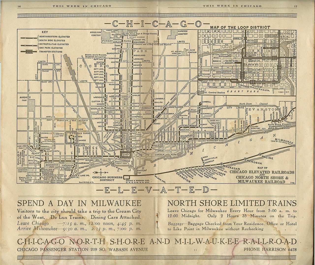
The Union Loop opened in 1897 and greatly increased the rapid transit system's convenience. Operation on the Yerkes-owned Northwestern Elevated, which built the North Side "L" lines, began three years later, essentially completing the elevated infrastructure in the urban core although extensions and branches continued to be constructed in outlying areas through the 1920s.

After 1911, the "L" lines came under the control of Samuel Insull, president of the Chicago Edison electric utility (now Commonwealth Edison), whose interest stemmed initially from the fact that the trains were the city's largest consumer of electricity. Insull instituted many improvements, including free transfers and through routing, although he did not formally combine the original firms into the Chicago Rapid Transit Company until 1924. He also bought three other Chicago electrified railroads, the Chicago North Shore and Milwaukee Railroad, Chicago Aurora and Elgin Railroad, and South Shore Line interurban lines, and ran the trains of the first two into downtown Chicago via the "L" tracks.
This period of relative prosperity ended when Insull's empire collapsed in 1932, but later in the decade the city, with the help of the federal government, accumulated sufficient funds to begin construction of two subway lines to supplement and, some hoped, permit eventual replacement of the Loop elevated; as early as the 1920s some city leaders wanted to replace the "ugly" elevated tracks. These plans advanced in the 1970s under mayors Richard J. Daley and Michael Bilandic until a public outcry against tearing down the popular "L" began, led by Chicago Tribune columnist Paul Gapp and architect Harry Weese. Instead, then new Mayor Jane Byrne protected the elevated lines and directed their rehabilitation.
The State Street subway opened on October 17, 1943. The Dearborn Subway, on which work had been suspended during World War II, opened on February 25, 1951. The subways were constructed with a secondary purpose of serving as bomb shelters, as evidenced by the close spacing of the support columns (a more extensive plan proposed replacing the entire elevated system with subways). The subways bypassed a number of tight curves and circuitous routings on the original elevated lines (Milwaukee trains, for example, originated on Chicago's northwest side but entered the Loop at the southwest corner), speeding service for many riders.
CTA assumes control
By the 1940s, the financial condition of the "L", and of Chicago mass transit in general, had become too precarious to permit continued operation without subsidies, and the necessary steps were taken to enable a public takeover. In 1947, the Chicago Transit Authority (CTA) acquired the assets of the Chicago Rapid Transit Company and the Chicago Surface Lines, operator of the city's streetcars. Over the next few years CTA modernized the "L", replacing wooden cars with new steel ones and closing lightly used branch lines and stations, many of which had been spaced only a quarter-mile apart.
Rail service to O'Hare International Airport first opened in 1984 and to Midway International Airport in 1993. That same year, the CTA renamed all of its rail lines; they are now identified by color. The CTA introduced fare cards for the first time in 1997.
Skip-stop service
Later, after assuming control of the "L", the CTA introduced A/B skip-stop service. Under this service, trains were designated as either "A" or "B" trains, and stations were alternately designated as "A" stations or "B" stations, with heavily used stations designated as both – "AB". "A" trains would stop only at "A" and "AB" stations, and "B" trains would stop only at "B" and "AB" stations. The system was designed to speed up lines by having trains skip stations while still allowing for frequent service at the heavily used "AB" stations.
A/B skip-stop service debuted on the Lake Street Elevated in 1948, and the service proved effective as travel times were cut by a third. By the 1950s, the service was used throughout the system. All lines used the A/B skip-stop service between the 1950s and the 1990s with the exception of the Evanston and Skokie lines, which were suburban-only lines and did not justify skip-stop service.
On the lines with branches, skip-stop service sent all "A" trains to one branch and "B" trains to another branch. Individual stops were not skipped beyond the points where those branches diverged. As time went by, the time periods which employed skip-stop service gradually decreased, as the waits at "A" and "B" stations became increasingly longer during non-peak service.
By the 1990s, use of the A/B skip-stop system was only used during rush hour service. Another problem was that trains skipping stations to save time still could not pass the train that was directly ahead, so skipping stations was not advantageous in all regards. In 1993, the CTA began to eliminate skip-stop service when it switched the southern branches of the West-South and North-South Lines to improve rider efficiency, creating the current Red and Green Lines. From this point, Green Line trains made all stops along the entire route, while Red Line trains stopped at all stations south of Harrison. The elimination of A/B skip-stop service continued with the opening of the all-stop Orange Line and the conversion of the Brown Line to all-stop service.
In April 1995, the last of the A/B skip-stop system was eliminated with the conversion of the O'Hare branch of the Blue Line and the Howard branch of the Red Line to all-stop service. The removal of skip-stop service resulted in some increases in travel times, and greatly increased ridership at former "A" and "B" stations due to increased train frequencies. Station signage highlighting the former skip-stop patterns would remain into the 2000s, when it was gradually replaced across the system.
New rolling stock
The first air-conditioned cars were introduced in 1964. The last pre–World War II cars were retired in 1973. New lines were built in expressway medians, a technique implemented in Chicago and followed by other cities worldwide. The Congress branch, built in the median of the Eisenhower Expressway, replaced the Garfield Park "L" in 1958. The Dan Ryan branch, built in the median of the Dan Ryan Expressway, opened on September 28, 1969, followed by an extension of the Milwaukee elevated into the Kennedy Expressway in 1970.
System renovation and service improvements
2000–2010
During the 2000s and 2010s, the CTA has completed several renovation and new construction projects.
Pink Line service began on June 25, 2006, though it did not include any new tracks or stations. The Pink Line travels over what was formerly a branch of the Blue Line from the 54th/Cermak terminal in Cicero to the Polk station in Chicago. Pink Line trains then proceed via the Paulina Connector to the Lake Street branch of the Green Line and then clockwise around the Loop elevated via Lake-Wabash-Van Buren-Wells. Douglas trains used the same route between April 4, 1954, and June 22, 1958, after the old Garfield Park "L" line was demolished to make way for the Eisenhower Expressway. The new route, which serves 22 stations, offered more frequent service for riders on both the Congress and Douglas branches. Pink Line trains could be scheduled independently of Blue Line trains, and ran more frequently than the Douglas branch of the Blue Line did.
In late 2007, trains were forced to operate at reduced speed over more than 22% of the system due to deteriorated track, structure, and other problems. By October 2008, system-wide slow zones had been reduced to 9.1% and by January 2010, total slow zones were reduced to 6.3%. CTA's Slow Zone Elimination Project is an ongoing effort to restore track work to conditions where trains no longer have to reduce speeds through deteriorating areas. The Loop received track work in 2012–2013. The Purple Line in Evanston received track work and viaduct replacement in 2011–2013. The Green Line Ashland branch received track work in 2013, prior to the Red Line Dan Ryan branch reconstruction.
The Brown Line Capacity Expansion Project enabled CTA to run eight-car trains on the Brown Line, and rebuilt stations to modern standards, including accessibility. Before the project, Brown Line platforms could only accommodate six-car trains, and increasing ridership led to uncomfortably crowded trains. After several years of construction, eight-car trains began to run at rush hour on the Brown Line in April 2008. The project was completed in December 2009, on time and on budget, with only minor punch list work remaining. The project's total cost was expected to be around $530 million.
2010–present
While various mayors of Chicago had recognized the importance of reliable public transit, Rahm Emanuel received credit for making improving service a top priority. In addition to local funding, he managed to secure federal dollars by lobbying.
One of the largest reconstruction projects in the CTA's history, at a cost of $425 million, was the Red Line South reconstruction project. From May 19, 2013, through October 20, 2013, the project closed and rebuilt the entire Dan Ryan branch—replacing and rebuilding all the tracks, ties, ballast and drainage systems—from Cermak-Chinatown to 95th/Dan Ryan. The station work involved renewing and improving eight stations, including new paint and lights, bus bridge improvements, new elevators at the Garfield, 63rd, and 87th stations and new roofs and canopies at some stations. "We are looking forward to providing our south Red Line customers with improved stations that are cleaner, brighter and better than they have been in years," said CTA President Forrest Claypool. Shutting down a portion of the railway instead of relegating work to the weekends enabled the project to be completed in months rather than years.
In 2014, the CTA initiated station and track upgrades on the Blue Line between Grand and O'Hare. This $492 million project has modernized stations (some of which were originally built in 1895), rebuilt tracks, replaced station platforms, upgraded water utilities, installed public art, and improved access to some stations (by adding elevators). This project, nearing completion as of 2022, is expected to cut travel time between the Loop and O'Hare by ten minutes.
In late 2015, extensive 4G wireless coverage was added to both Blue and Red Line subways, with the $32.5 million installation cost paid for by T-Mobile, Sprint, AT&T, and Verizon. Upon the project's completion, Chicago became the largest American city with 4G Internet service in all of its subways and tunnels, a total of 22 miles (35 km). Besides adding to passenger convenience, it also improved security by allowing CTA personnel and first responders to communicate more easily in case of an emergency.
The new Wilson Station officially reopened in October 2017. The century-old station now includes accessible elevators, escalators, new security cameras, three entrances, wider stairwells, additional turnstiles, larger platforms, new lights and signage, as well as bus and train trackers.
FastTracks is a program intended to address the slow zones and to make train rides smoother and more reliable. In order to achieve this, crews would replace worn tracks, rail ties, and ballasts. An upgraded power system along the O'Hare Blue Line branch would enable more trains to operate during peak periods. The Blue, Brown, Green, and Red lines would be worked on. This program was set to begin in early 2018 and would continue through 2021. Funding for this $179 million project comes from a fee increase imposed on mobile app–based vehicle for hire companies in Chicago, the first of its kind in the country. In Mayor Emanuel's 2018 budget proposal, the fee went from 52 cents to 67 cents per trip. First introduced in 2015, this fee rose by another five cents in 2019.
In December 2018, The CTA Board approved $2.1 billion worth of contracts for the modernization of the Red and Purple Lines. The largest and most expensive in CTA history, this project includes the reconstruction of the junction between the Brown Line and Red/Purple line into a flying junction to reduce delays, and the reconstruction of the Lawrence, Argyle, Berwyn, and Bryn Mawr stations. Construction of the project began on October 2, 2019, and was completed on July 20, 2025. $100 million in federal funding for the reconstruction of the Red Line was approved September 2019. In the final days of the Barack Obama administration, the federal government agreed to provide $957 million in funding in total; the rest would come from a tax hike on property owners who lived within 0.5 miles (800 m) of the Red Line.
Google announced in November 2024 that it would pay for the redesign of the Clark/Lake station in a project related to the company's new Chicago headquarters at the former Thompson Center.
The Chicago Department of Transportation (CDOT) announced in December 2025 that State/Lake station would be closed on January 5 for demolition. The station is to be rebuilt with greater accessibility, wider platforms, a continuous canopy, a pedestrian flyover bridge by 2029. The project is estimated to cost $444 million.
Operations
As of 2014, Chicago "L" trains run over a total of 224.1 miles (360.7 km) of track.
Ridership
Ridership has been growing steadily after the CTA takeover despite declining mass transit usage nationwide, with an average of 594,000 riders boarding each weekday in 1960 and 759,866 in 2016 (or 47% of all CTA rides). Due to the Loop Flood in April 1992, ridership was at 418,000 that year because CTA was forced to suspend operation for several weeks in both the State and Dearborn subways, used by the most heavily traveled lines.
Growing ridership has not been uniformly distributed. Use of North Side lines is heavy and continues to grow, while that of West Side and South Side lines tend to remain stable. Ridership on the North Side Brown Line, for instance, has increased 83% since 1979, necessitating a station reconstruction project to accommodate longer trains.
Annual traffic on the Howard branch of the Red Line, which reached 38.7 million in 2010 and 40.9 million in 2011, has exceeded the 1927 prewar peak of 38.5 million. The section of the Blue Line between the Loop and Logan Square, which serves once-neglected but now bustling neighborhoods such as Wicker Park, Bucktown, and Palmer Square, has seen a 54% increase in weekday riders since 1992. On the other hand, weekday ridership on the South Side portion of the Green Line, which closed for two years for reconstruction from January 1994 to May 1996, was 50,400 in 1978 but only 13,000 in 2006.
Boardings at the 95th/Dan Ryan stop on the Red Line, though still among the system's busiest at 11,100 riders per weekday as of February 2015, are less than half the peak volume in the 1980s. In 1976, three North Side "L" branches – what were then known as the Howard, Milwaukee, and Ravenswood lines − accounted for 42% of non-downtown boardings. Today (with the help of the Blue Line extension to O'Hare), they account for 58%.
The North Side, which has historically been the highest density area of the city, reflects the Chicago building boom between 2000 and 2010, which has focused primarily on North Side neighborhoods and downtown. It may ease somewhat in the wake of the current high level of residential construction along the south lakefront. For example, ridership at the linked Roosevelt stops on the Green, Orange, and Red Lines, which serve the burgeoning South Loop neighborhood, has tripled since 1992, with an average of 8,000 boardings per weekday.
Patronage at the Cermak-Chinatown stop on the Red Line, with 4,000 weekday boardings, is at the highest level since the station opened in 1969. The 2003 Chicago Central Area Plan proposed construction of a Green Line station at Cermak, between Chinatown and the McCormick Place convention center, in expectation of continued density growth in the vicinity. This station opened in 2015.
Service
Currently, the Red Line and the Blue Line provide 24-hour service, while all other lines operate from early morning to late night. Prior to 1998, the Green Line, the Purple Line and the Douglas branch of the Blue Line (the modern-day Pink Line) also had 24-hour service. In the years of private ownership, the South Side Elevated Railroad (now the South Side Elevated portion of the Green Line) provided 24-hour service, a major advantage when compared to Chicago's cable railroads, which required daily overnight shutdown for cable maintenance. There are plans to add 24-hour service to the Orange Line with some of the funding received from Senate Bill 2111.
Fares
In 2013, the CTA introduced a new fare payment system called Ventra. Ventra enables passengers to purchase individual tickets, passes, or transit value online, by smart phone, or at participating retail locations. Ventra also works with CTA buses, Pace (suburban buses), and Metra (commuter rail). Payment by a smartphone app, the Ventra app, or by a contactless bankcard is possible.
As of 2018, the "L" uses a flat fare of $2.50 for almost the entire system, the only exception being O'Hare International Airport on the Blue Line, at which passengers entering the station are charged a higher fare of $5.00 (passengers leaving the system at this station are not charged this higher fare). The higher fare is being charged for what the CTA considers "premium-level" service to O'Hare. Use of the Midway International Airport station does not require this higher fare; it only requires the $2.50 regular fare.
In 2013, the higher charge at O'Hare has been the source of some controversy, because of the CTA's plan to eliminate the exemption from the premium fare for airport workers, Transportation Security Administration workers, and airline workers. After protests from those groups, the CTA extended the exemptions for six months.
Fare control
The CTA uses fare gates to verify that passengers have paid their fare. As of 2026, most gates at staffed stations use a rotating single bar that only rotates when you pay your fare. Some entrances that are unstaffed use high barrier fare gates, which are much harder to open making fare evasion levels go down. In order to comply with the Americans with Disabilities Act of 1990, the CTA has wider gates that allow wheelchairs and suitcases to pass through easily. Such gates were updated in 2023 to make them taller and improve the locking mechanism, further discouraging fare evasion. In March 2026, the CTA announced in response to their funding being cut by the FTA that they would install more high barrier fare gates at stations with high levels of fare evasion.
Lines
Since 1993, "L" lines have been officially identified by color, although older route names survive to some extent in CTA publications and popular usage to distinguish branches of longer lines. Stations are found throughout Chicago, as well as in the suburbs of Forest Park, Oak Park, Evanston, Wilmette, Cicero, Rosemont, and Skokie.