
Cebu ( seb-OO; Cebuano: Sugbo), officially the Province of Cebu (Cebuano: Lalawigan sa Sugbo; Filipino: Lalawigan ng Cebu), is a province of the Philippines located in the Central Visayas (Region VII) region, and consists of a main island and 167 surrounding islands and islets. The coastal zone of Cebu is identified as a site of highest marine biodiversity importance in the Coral Triangle.
Its capital and largest city is Cebu City, nicknamed "the Queen City of the South", is the oldest city and first capital of the Philippines, which is politically independent from the provincial government along with Mandaue and Lapu-Lapu City. The Cebu Metropolitan Area or Metro Cebu is the third largest metropolitan area in the Philippines (after Metro Manila and Metro Davao) with Cebu City as the main center of commerce, trade, education and industry in the Visayas as well as the regional center of Central Visayas. Being one of the most developed provinces in the Philippines, in a decade it has transformed into a global hub for business processing services, tourism, shipping, furniture-making, and heavy industry. Mactan–Cebu International Airport, located on Mactan Island, is the second busiest airport in the Philippines.
Cebu has the most combined cities and municipalities of any province in the Philippines, with 53 in total. With 9 cities in total, it has the second highest number of cities after its neighboring province of Negros Occidental.

Etymology
It is unclear whether the island was named sugbó or the settlement where Ferdinand Magellan's crew arrived in 1521. The capital city of the province is also named Cebu City.
The name is possibly derived from a hypothetical Proto-Philippine word *sug(e)bu meaning "to bathe" or "to wade into the water". The word has evolved in the Cebuano language as sugbú, meaning "to dive into water" and also exists in other Philippine languages such as Tagalog and Hiligaynon. In fact, there is also another municipality in Batangas, Philippines called Nasugbu, which may also share the same etymological root with the said province.
The modern name is most likely how the first Europeans heard of the name of the place in the 16th–17th centuries, as it was first recorded as Zubu or Çubu, and then eventually it became Cebu. The reason for the spelling change is because Visayans were mostly illiterate in the 16th and 17th centuries.

History
Early history
Cebu was a native kingdom that existed prior to the arrival of the Spaniards. Visayan folklore relates it was founded by Sri Lumay otherwise known as Rajamuda Lumaya, a half-Malay, half-Tamil from Sumatra. The capital of the nation was Singhapala (சிங்கப்பூர்) which is Tamil-Sanskrit for "Lion City", the same root word as with the modern city-state of Singapore. The later Spanish chronicler Antonio Pigafetta mispronounced Singhapala as Cingopola instead.
Spanish Colonial Period
Report from the Magellan Expedition
The arrival of Portuguese explorer Ferdinand Magellan in 1521 began a period of Spanish exploration and colonization. Losing the favor of King Manuel I of Portugal for his plan of reaching the Spice Islands by sailing west from Europe, Magellan offered his services to King Charles I of Spain (Charles V, Holy Roman Emperor). On September 20, 1519, Magellan led five ships with a total complement of 250 people from the Spanish fort of Sanlúcar de Barrameda en route to southeast Asia via the Americas and the Pacific Ocean. They reached the Philippines on March 16, 1521. Rajah Kolambu, the rajah of Mazaua told them to sail for Cebu, where they could trade and obtain provisions.
Arriving in Cebu City, Magellan, with Enrique of Malacca as a translator, befriended Rajah Humabon a chief of a village in Cebu, and persuaded the natives to ally themselves with the Spanish. On April 14, Magellan erected a large wooden cross on the shores of Cebu. Afterwards, Rajah Humabon was baptized along with about 400 Sugbuanons.
Magellan soon heard of Datu Lapu-Lapu, a native chief in nearby Mactan Island, a rival of a chief in Cebu. It was thought that Humabon and Lapu–Lapu had been fighting for control of the flourishing trade in the area. On April 27 the Battle of Mactan occurred, where the Spaniards were defeated and Magellan was killed by the natives of Mactan in Mactan Island. According to Italian historian and chronicler Antonio Pigafetta, Magellan's body was never recovered despite efforts to trade it for spice and jewels. Magellan's second-in-command, Juan Sebastián Elcano, took his place as captain of the expedition and sailed the fleet back to Spain, circumnavigating the world.
Survivors of the Magellan expedition returned to Spain with tales of a savage island in the East Indies. Consequently, several Spanish expeditions were sent to the islands but all ended in failure.
Report from the Legazpi Expedition
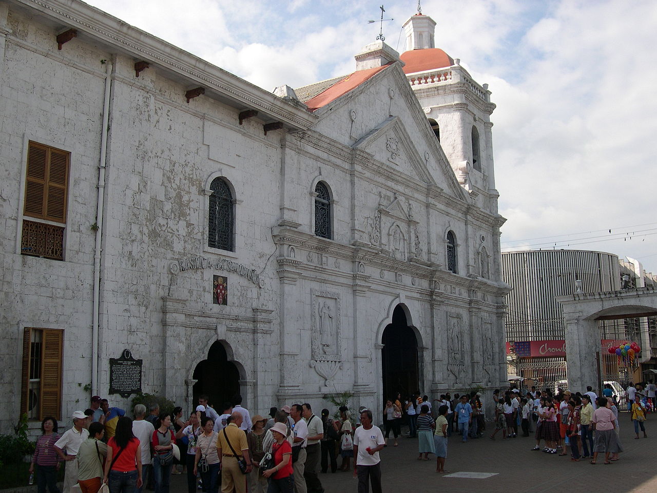
On April 27, 1565 Miguel López de Legazpi arrived on the island, and though he also intended to make peace, he was also prepared for a war since these were the same people that had killed Magellan 44 years prior. According to the report, a messenger went to the Spanish ship and informed them that Tupas and "along with 10 other chiefs" would be out to either make negotiations or as a warning to prepare for an upcoming battle. Despite trying to assure the natives that the Spanish were there with good intentions, the natives already armed themselves, both parties were reported to have taunted each other offshore. Legazpi aimed the artillery on the proas which briefly confused the opposing natives causing them to run into the woods thus making the shore clear for the Spanish to land. Salvaging any valuable item that could be found, Juan de Camuz came across an image of the Child Jesus, which was probably the one Magellan presented to the consort of the chief in 1521. From then on, a church was built on the site which would later become the Minor Basilica of the Holy Child. Twelve days later, on May 8, a fort was established and while the construction was ongoing, the natives frequently launched attacks but were always repulsed until eventually they gave in as soon as they realized the superior armament of the Europeans. Legazpi dealt only with Tupas, after a brief "trial" on grounds of apostasy and Magellan's murder, the Europeans pardoned the natives' chief and included the natives. After the exchange, the two parties then discussed the terms and conditions including confirmation of titles, who receives tax exemptions, land grants, authority and recognition of officials. The crew then left Cebu on June 1, 1565.

In the 1700s, Cebu housed 625 Spanish Filipino families and 28,112 native families There were 5 Conquistadors from Latin America that were given encomiendas in the region of Cebu. First was Adelantado Miguel Lopez de Legaspi, leader of the expedition from Mexico, he was given a large encomienda of an unknown number of Filipino tributaries. Next, is Jerónimo de Monzón, whose number of tributes was also not specifically cited. Cristóbal Sánchez, was mentioned next, with 3000 native Cebuano tributes, Followed by, Francisco Carreño with about 2000 Cebuano tributes, Afterwards, Andrés de Mirandaola with 1,000 tributes which are also in Cebu, and finally Pedro Arana, whose precise number of tributes are not specifically quantified. All of these Mexican conquistadors were given lands and encomiendas in and around the region of Cebu.
By the time of the 1818 census, the native Filipino families numbered 31,134 while the number of Spanish-Filipino families that settled in the archdiocese of Cebu increased to 631. Their number and cities or municipalities of residency are as follows: the distribution was centered primarily in Cebu City (Fort San Pedro) with 233 families, and the separate city of the Parián (The Chinatown) with 109, other notable concentrations included 75 families on Bantayan Island, 69 in Samboan, 57 in Danao, 20 in Mandaue, and 14 in Barili. This total also encompasses Spanish-Filipino families residing in the subordinate islands of Bohol, Siquijor, Dauis, and the Camotes Islands.
American colonial period
In 1898, the island was ceded to the United States after the Spanish–American War and Philippine–American War. In 1901, Cebu was governed by the United States for a brief period, however, it became a chartered city on February 24, 1937, and was governed independently by Filipino politicians.
Japanese occupation
Cebu, being one of the most densely populated islands in the Philippines, served as a Japanese base during their occupation in World War II which began with the landing of Japanese soldiers in April 1942. A Japanese businessman established Cebu's first "comfort station" during the war, where Japanese soldiers routinely gang-raped, humiliated, and murdered kidnapped girls and teenagers who they forced into sexual slavery under the brutal "comfort women" system. The 3rd, 8th, 82nd and 85th Infantry Division of the Philippine Commonwealth Army was re-established from January 3, 1942, to June 30, 1946, and the 8th Constabulary Regiment of the Philippine Constabulary was reestablished again from October 28, 1944, to June 30, 1946, at the military general headquarters and the military camps and garrisoned in Cebu city and Cebu province. They started the Anti-Japanese military operations in Cebu from April 1942 to September 1945 and helped Cebuano guerrillas and fought against the Japanese Imperial forces. Almost three years later in March 1945, combined Filipino and American forces landed and reoccupied the island during the liberation of the Philippines. Cebuano guerrilla groups led by an American, James M. Cushing, is credited for the establishment of the "Koga Papers", which is said to have changed the American plans to retake the Philippines from Japanese occupation in 1944, by helping the combined United States and the Philippine Commonwealth Army forces enter Cebu in 1945. The following year the island achieved independence from colonial rule in 1946.
During the Marcos dictatorship
Cebu became a key center of resistance against the Marcos dictatorship, first becoming apparent when the hastily put-together lineup of Pusyon Bisaya defeated the entire slate of Marcos' Kilusang Bagong Lipunan (KBL) in Region VII.
Among the Cebuanos immediately arrested by the Marcos dictatorship when martial law was announced on September 23, 1972, were columnist and future National Artist Resil Mojares and human rights lawyer and Carcar Vice Mayor Democrito Barcenas, who were both detained at Camp Sergio Osmeña.
One of the Marcos Martial Law Desaparecidos from Cebu was Redemptorist Priest Fr. Rudy Romano, a prominent Marcos critic and Executive Secretary of Cebu's Coalition against People's Persecution, who was accosted by armed men in Tisa, Labangon, Cebu City on June 11, 1985, and never seen again. Levi Ybañez, Romano's colleague in the Coalition against People's Persecution, was abducted on the same day as Fr. Romano, and was also never heard from again. Ribomapil Holganza, a prominent leader of Cebu's opposition was also arrested together with his son on Christmas Day, December 25, 1983, on political charges. He was subsequently released and cleared of all charges.
The Marcos era was a time of significant deforestation in Cebu and throughout the Philippines, with the forest cover of the Philippines shrinking until only 8% remained. In Cebu, two of the major companies given Timber License Agreements (TLAs) to cut down trees during Martial Law were Eurasia Match and Pan Oriental, which were owned by Juan Ponce Enrile. Enrile was the government official Ferdinand Marcos put in place to approve Timber License Agreements during Martial Law.
Role in the People Power Revolution
Later, Cebu would play a key role in the days leading up to the 1986 People Power revolution and the ouster of Marcos. It was from Fuente Osmeña circle in Cebu City that the opposition forces relaunched the Civil Disobedience Campaign against the Marcos regime and its cronies on February 22, 1986. After that, the Carmelite Monastery in Barangay Mabolo, Cebu City, served as a refuge for opposition candidates Corazon Aquino and Salvador Laurel during the first day of the People Power revolution, because it was not yet safe to go back to Manila.
Contemporary
In 2007, the municipalities of Bogo, Carcar, and Naga became component cities. Their respective cityhood laws were ratified in the same year. However, their cityhood status was lost twice in the years 2008 and 2010 after the LCP questioned the validity of the cityhood laws. Their cityhood status was reaffirmed after the court finalized its ruling on February 15, 2011, declaring their respective cityhood laws constitutional.
In February 2012, Cebu island experienced the effects of magnitude 6.7 earthquake on the neighboring island of Negros and was the largest quake in the area for 90 years. The tremor shook buildings but there were no reports of major building damage or loss of life on Cebu Island itself. This tremor was caused by a previously unrecorded fault.
In October 2013, Cebu and Bohol were hit by a record-setting 7.2 magnitude earthquake which left 222 dead and collapsed some buildings, including 5 historical churches. There were over 700 aftershocks. The northern part of the province was devastated by Typhoon Haiyan a month later.
In December 2021, Typhoon Rai wreaked havoc across the province, leading to a declaration of "calamity" by the government.
On September 30, 2025, northern Cebu was struck by an earthquake with a magnitude of 6.9, with dozens of fatalities and hundreds of injured.
Geography
Cebu is located to the east of Negros, to the west of Leyte and Bohol islands. The province consists of Cebu Island, as well as 167 smaller islands, which include Mactan, Bantayan, Malapascua, Olango and the Camotes Islands. But the highly urbanized cities of Cebu, Lapu-Lapu and Mandaue are independent cities not under provincial supervision, yet are often grouped with the province for geographical and statistical purposes.
The province's land area is 4,944 square kilometers (1,909 sq mi), or when the three independent cities (Cebu City, Lapu-Lapu and Mandaue) are included for geographical purposes, the total area is 5,342 square kilometers (2,063 sq mi).
Cebu's central location, proximity to an unusually exotic tourist destination, ready access to a diversity of plant, animal and geological wonders within the island, and remoteness from earthquake and typhoon activity are some of the special attributes of Cebu.
Cebu Island
Cebu Island is the 126th largest island in the world. Cebu Island itself is long and narrow, stretching 196 kilometers (122 mi) from north to south and 32 kilometers (20 mi) across at its widest point. It has narrow coastlines, limestone plateaus, and coastal plains. It also has rolling hills and rugged mountain ranges traversing the northern and southern lengths of the island.
Cebu's highest mountains are over 1,000 metres (3,300 ft) high. Flat tracts of land can be found in the city of Bogo and in the towns of San Remigio, Medellin and Daanbantayan at the northern region of the province.
The island's area is 4,468 square kilometres (1,725 sq mi), making it the 9th largest island in the Philippines. It supports over 5.2 million people, of which an estimated 2.9 million live in Metro Cebu.
Beaches, coral atolls, islands, and rich fishing grounds surround Cebu.
Coal was first discovered in Cebu about 1837. There were 15 localities over the whole island, on both coasts; some desultory mining had been carried out Naga near Mount Uling, but most serious operations were at Licos and Camansi west of Compostela and Danao. Active work ceased about 1895 with the insurrections, and no production was worked on for more than ten years. A topographic and geologic survey of Compostela, Danao, and Carmen took place in 1906. The Compostela-Danao coalfield contained about six million workable tons. The tramroads, one from Danao to Camansi, one from Compostela to Mount Licos, were undertaken in 1895, together with a wagon road built in 1877, from Cotcot to Dapdap.
Climate
The climate of Cebu is tropical. There are 2 seasons in Cebu − the dry and wet season. It is dry and sunny most of the year with some occasional rains during the months of June to December. The province of Cebu normally gets typhoons once a year or none.
Northern Cebu gets more rainfall and typhoons than southern Cebu because it has a different climate. Typhoon Haiyan (Yolanda) hit Northern Cebu in 2013 killing 73 people and injuring 348 others. Though most typhoons hit only the northern part of Cebu, the urban areas in central Cebu are sometimes hit, such as when Typhoon Mike (Ruping), one of the worst to hit Cebu lashed the central Cebu area in 1990. 31 years later, Typhoon Rai struck the central and southern portions of the province.
Cebu's temperatures can reach a high of 36 °C (97 °F) from March to May, and as low as 18 °C (64 °F) in the mountains during the wet season. The average temperature is around 24 to 34 °C (75 to 93 °F), and does not fluctuate much except during the month of May, which is the hottest month. Cebu averages 70–80% humidity.
Fauna
Endemic species in Cebu include the Cebu Flowerpecker (Dicaeum quadricolor), Cebu Slender Skink (Brachymeles cebuensis), Uling Goby (Sicyopus cebuensis), and Black Shama (Copsychus cebuensis).
There is also a subspecies of Idea leuconoe that is only endemic to Cebu. I. l. jumaloni is endemic to the area of Kawasan Falls in Badian, hence its common name, the Kawasan Paper Kite Butterfly. The subspecies is also named after Julian Jumalon, a Cebuano Lepidopterist and butterfly artist. The butterfly can also be observed in the Nug-as rainforest.
Flora
Cebu has little remaining forest cover. The remaining forest patches in Cebu are composed primarily of the following tree species.
Mount Lantoy: Carallia brachiata and introduced species Tectona grandis, Swietenia macrophylla, Gmelina arborea, and Casuarina equisetifolia
Palinipinon Mountains: Carallia brachiata and introduced species Swietenia macrophylla
Nug-as forest: Ficus spp., Artocarpus blancoi, Macaranga grandifolia, and Cinnamomum cebuense
Mount Lanaya: Carallia brachiata