
Benin, officially the Republic of Benin, formerly known as Dahomey, is a country in West Africa. It is bordered by Togo to the west, Nigeria to the east, Burkina Faso to the northwest, and Niger to the northeast. The majority of its population lives on the southern coastline of the Bight of Benin, part of the Gulf of Guinea in the northernmost tropical portion of the Atlantic Ocean. The capital is Porto-Novo, and the seat of government is in Cotonou, the most populous city and economic capital. Benin covers an area of 112,622 km2 (43,484 sq mi), and its population in 2021 was estimated to be approximately 13 million. It is a tropical country with an economy heavily dependent on agriculture and the exports of palm oil and cotton.
From the 17th to the 19th centuries, political entities in the area included the Kingdom of Dahomey, the city-state of Porto Novo, and other states to the north. France took over the territory in 1894, incorporating it into French West Africa as French Dahomey. In 1960, Dahomey gained full independence from France. As a sovereign state, Benin has had democratic governments, military coups, and military governments. A self-described Marxist–Leninist state called the People's Republic of Benin existed between 1975 and 1990. In 1991, it was replaced by the multi-party Republic of Benin.
The official language of Benin is French, with indigenous languages such as Fon, Bariba, Yoruba and Dendi also spoken. The largest religious group in Benin, as projected for 2020 by Pew Research Group based on 2010 statistics, is Christianity (52.2%), followed by Islam (24.6%) and African traditional religions (17.9%). Benin is a member of the United Nations, the African Union, the Economic Community of West African States, the Organisation of Islamic Cooperation, the South Atlantic Peace and Cooperation Zone, Francophonie, the Community of Sahel–Saharan States, the African Petroleum Producers Association and the Niger Basin Authority.

Etymology
During French colonial rule and after independence on 1 August 1960, the country was named Dahomey, after the Kingdom of Dahomey. On 30 November 1975, following a Marxist–Leninist military coup (the 1972 Dahomeyan coup d'état), the country was renamed Benin, after the Bight of Benin, which borders the country, since the name Dahomey is exclusively associated with the Fon who inhabited the southern half of the country. The bight takes its name from the Kingdom of Benin, located in present-day Nigeria.
History
Pre-colonial
Prior to 1600, present-day Benin comprised a variety of areas with different political systems and ethnicities. These included city-states along the coast (primarily of the Aja ethnic group and also including Yoruba and Gbe peoples) and tribal regions inland (composed of Bariba, Mahi, Gedevi, and Kabye peoples). The Oyo Empire, located primarily to the east of Benin, was a military force in the region, conducting raids and exacting tribute from the coastal kingdoms and tribal regions. The situation changed in the 17th and 18th centuries as the Kingdom of Dahomey, consisting mostly of Fon people, was founded on the Abomey plateau and began taking over areas along the coast. By 1727, King Agaja of the Kingdom of Dahomey had conquered the coastal cities of Allada and Whydah. Dahomey had become a tributary of the Oyo Empire, and rivaled but did not directly attack the Oyo-allied city-state of Porto-Novo. The rise of Dahomey, its rivalry with Porto-Novo, and tribal politics in the northern region persisted into the colonial and post-colonial periods.
In the Dahomey, some younger people were apprenticed to older soldiers and taught the kingdom's military customs until they were old enough to join the army. Dahomey instituted an elite female soldier corps variously called Ahosi (the king's wives), Mino ("our mothers" in Fongbe) or the "Dahomean Amazons". This emphasis on military preparation and achievement earned Dahomey the nickname of "Black Sparta", from European observers and 19th-century explorers such as Sir Richard Burton.

The kings of Dahomey sold their war captives into transatlantic slavery or killed them ritually in a ceremony known as the Annual Customs. By about 1750, the King of Dahomey was earning an estimated £250,000 per year by selling African captives to European slave-traders. The area was named the "Slave Coast" because of a flourishing slave trade. Court protocols which demanded that a portion of war captives from the kingdom's battles be decapitated, decreased the number of enslaved people exported from the area. The number went from 102,000 people per decade in the 1780s to 24,000 per decade by the 1860s. The decline was partly due to the Slave Trade Act 1807 banning the trans-Atlantic slave trade by Britain in 1808, followed by other countries. This decline continued until 1885 when the last slave ship departed the modern Benin Republic for Brazil, which had yet to abolish slavery. The capital Porto-Novo ("New Port" in Portuguese) was originally developed as a port for the slave trade.
Among the goods the Portuguese sought were carved items of ivory made by Benin's artisans in the form of carved saltcellars, spoons, and hunting horns – pieces of African art produced for sale abroad as exotic objects. Another major good sought by European settlers was palm oil. In 1856, approximately 2,500 tons of palm oil was exported by British companies which was valued at £112,500.
Colonial
By the middle of the 19th century, Dahomey had "begun to weaken and lose its status as the regional power". The French took over the area in 1892. In 1899, the French included the land called French Dahomey within the larger French West Africa colonial region.
France sought to benefit from Dahomey and the region "appeared to lack the necessary agricultural or mineral resources for large-scale capitalist development". As a result, France treated Dahomey as a sort of preserve in case future discoveries revealed resources worth developing.
The French government outlawed the capture and sale of slaves. Previous slaveowners sought to redefine their control over slaves as control over land, tenants, and lineage members. This provoked a struggle among Dahomeans, "concentrated in the period from 1895 to 1920, for the redistribution of control over land and labor. Villages sought to redefine boundaries of lands and fishing preserves. Religious disputes scarcely veiled the factional struggles over control of land and commerce which underlay them. Factions struggled for the leadership of great families".
In 1958, France granted autonomy to the Republic of Dahomey, and full independence on 1 August 1960 which is celebrated each year as Independence Day, a national holiday. The president who led the country to independence was Hubert Maga.

Post-colonial
After 1960, there were coups and regime changes, with the figures of Hubert Maga, Sourou Migan Apithy, Justin Ahomadégbé, and Émile Derlin Zinsou dominating; the first three each represented a different area and ethnicity of the country. These three agreed to form a Presidential Council after violence marred the 1970 elections.
On 7 May 1972, Maga ceded power to Ahomadégbé. On 26 October 1972, Lt. Col. Mathieu Kérékou overthrew the ruling triumvirate, becoming president and stating that the country would not "burden itself by copying foreign ideology, and wants neither Capitalism, Communism, nor Socialism". On 30 November 1974, he announced that the country was officially Marxist, under control of the Military Council of the Revolution (CMR), which nationalized the petroleum industry and banks. On 30 November 1975, he renamed the country the People's Republic of Benin. The regime of the People's Republic of Benin underwent changes over the course of its existence: a nationalist period (1972–1974); a socialist phase (1974–1982); and a phase involving an opening to Western countries and economic liberalism (1982–1990).
In 1974, the government embarked on a program to nationalize strategic sectors of the economy, reform the education system, establish agricultural cooperatives and new local government structures, and a campaign to eradicate "feudal forces" including tribalism. The regime banned opposition activities. Mathieu Kérékou was elected president by the National Revolutionary Assembly in 1980, re-elected in 1984. Establishing relations with China, North Korea, and Libya, he put "nearly all" businesses and economic activities under state control, causing foreign investment in Benin to dry up. Kérékou attempted to reorganize education, pushing his own aphorisms such as "Poverty is not a fatality". The regime financed itself by contracting to take nuclear waste, first from the Soviet Union and later from France.

In the 1980s, Benin experienced higher economic growth rates (15.6% in 1982, 4.6% in 1983 and 8.2% in 1984), until the closure of the Nigerian border with Benin led to a drop in customs and tax revenues. The government was no longer able to pay civil servants' salaries. In 1989, riots broke out when the regime did not have enough money to pay its army. The banking system collapsed. Eventually, Kérékou renounced Marxism, and a convention forced Kérékou to release political prisoners and arrange elections. Marxism–Leninism was abolished as the country's form of government.
The country's name was officially changed to the Republic of Benin on 1 March 1990, after the newly formed government's constitution was completed. Kérékou lost to Nicéphore Soglo in a 1991 election and became the first president on the African mainland to lose power through an election. Kérékou returned to power after winning the 1996 vote. In 2001, an election resulted in Kérékou winning another term, after which his opponents claimed election irregularities. In 1999, Kérékou issued a national apology for the substantial role that Africans had played in the Atlantic slave trade.
21st century
Kérékou and former president Soglo did not run in the 2006 elections, as both were barred by the constitution's restrictions on age and total terms of candidates. The Beninese presidential election, 2006 resulted in a runoff between Thomas Boni Yayi and Adrien Houngbédji. The runoff election was held on 19 March and was won by Boni, who assumed office on 6 April. Boni was reelected in 2011, taking 53.18% of the vote in the first round—enough to avoid a runoff election. He was the first president to win an election without a runoff since the restoration of democracy in 1991.
In the March 2016 presidential elections in which Boni Yayi was barred by the constitution from running for a third term, businessman Patrice Talon won the second round with 65.37% of the vote, defeating investment banker and former Prime Minister Lionel Zinsou. Talon was sworn in on 6 April 2016. Speaking on the same day that the Constitutional Court confirmed the results, Talon said that he would "first and foremost tackle constitutional reform", discussing his plan to limit presidents to a single term of 5 years to combat "complacency". He said that he planned to slash the size of the government from 28 to 16 members. In April 2021, President Patrice Talon was re-elected, with more than 86.3% of the votes cast in the 2021 Beninese presidential election. The change in election laws resulted in total control of parliament by president Talon's supporters.
In February 2022, Benin saw its largest terrorist attack in history, the W National Park massacre. On 20 February 2022, President Talon inaugurated an exhibition with 26 pieces of sacred art returned to Benin by France, 129 years after they were looted by colonial forces.
In March 2025, the government of Benin adopted a law, recognizing 16 kingdoms, 80 senior chiefs and 10 traditional chiefs through a new law. The pre-colonial period starting in 1894 for the south and 1897 for the north served as a historical reference for the bill, identifying traditional territories and rules to institutionalize chieftaincy.
In July 2025, the My Afro Origins law went into effect, granting the right of provisional Beninese citizenship to members of the African diaspora whose ancestry was impacted by the transatlantic slave trade.
On 7 December 2025, a coup attempt occurred in which a faction of the army led by Pascal Tigri claimed to have overthrown President Talon and suspended the government and all political parties. However, the government later announced it had suppressed the coup and regained full control of all institutions, although Talon's whereabouts were unknown.
Geography
The north–south strip of land in West Africa lies between latitudes 6° and 13°N, and longitudes 0° and 4°E. It is bounded by Togo to the west, Burkina Faso and Niger to the north, Nigeria to the east, and the Bight of Benin to the south. The distance from the Niger River in the north to the Atlantic Ocean in the south is about 650 km (404 mi). Although the coastline measures 121 km (75 mi), the country measures about 325 km (202 mi) at its widest point. Four terrestrial ecoregions lie within Benin's borders: Eastern Guinean forests, Nigerian lowland forests, Guinean forest-savanna mosaic, and West Sudanian savanna. It had a 2018 Forest Landscape Integrity Index mean score of 5.86/10, ranking it 93rd globally out of 172 countries.
Benin shows some variation in elevation and can be divided into four areas from the south to the north, starting with the lower-lying, sandy, coastal plain (highest elevation 10 m or 32.8 ft) which is, at most, 10 km (6.2 mi) wide. It is marshy and dotted with lakes and lagoons communicating with the ocean. Behind the coast lies the Guinean forest-savanna mosaic-covered plateaus of southern Benin (altitude between 20 and 200 m or 66 and 656 ft), which are split by valleys running north to south along the Couffo, Zou, and Ouémé Rivers.
This geography makes it vulnerable to climate change. With the majority of the country living near the coast in lower-lying areas, sea level rise could affect the economy and population. Northern areas will see additional regions become deserts.
An area of flatter land dotted with rocky hills whose altitude reaches 400 m (1,312 ft) extends around Nikki and Save.
A range of mountains extends along the northwest border and into Togo; these are the Atacora. The highest point, Mont Sokbaro, is at 658 m (2,159 ft). Benin has fields, mangroves and remnants of forests. In the rest of the country, the savanna is covered with thorny scrub and dotted with baobab trees. Some forests line the banks of rivers. In the north and the northwest of Benin, the Reserve du W du Niger and Pendjari National Park has African bush elephants, lions, antelopes, hippopotamus and monkeys. Pendjari National Park together with the bordering Parks Arli and W National Park in Burkina Faso and Niger are among the strongholds of the lion in West Africa; with an estimated 246–466 lions, W-Arli-Pendjari harbors the largest remaining lion population in West Africa. Historically Benin has served as habitat for the endangered African wild dog, Lycaon pictus; this canid is thought to have been locally extinct.
Annual rainfall in the coastal area averages 1300 mm or about 51 inches. Benin has two rainy and two dry seasons per year. The principal rainy season is from April to late July, with a shorter, less intense rainy period from September to November. The main dry season is from December to April, with a cooler dry season from July to September. Temperatures and humidity are higher along the tropical coast. In Cotonou, the average maximum temperature is 31 °C (87.8 °F); the minimum is 24 °C (75.2 °F).
Variations in temperature increase when moving north through savanna and plateau toward the Sahel. A dry wind from the Sahara called the harmattan blows from December to March, when the grass dries up, other vegetation turns reddish-brown, and a veil of fine dust hangs over the country, causing the skies to be overcast. It is also the season when farmers burn brush in the fields.
In Benin forest cover is around 28% of the total land area, equivalent to 3,135,150 ha (12,104.9 sq mi) of forest in 2020, down from 4,835,150 ha (18,668.6 sq mi) in 1990. In 2020, naturally regenerating forests covered 3,112,150 ha (12,016.1 sq mi), and planted forests covered 23,000 ha (89 sq mi).
Wildlife
Government and politics
Benin's politics take place in a framework of a presidential representative democratic republic in which the President of Benin is both head of state and head of government, within a multi-party system. Executive power is exercised by the government. Legislative power is vested in the government and the legislature. The judiciary is officially independent of the executive and the legislature, while in practice its independence has been gradually hollowed out by Talon, and the Constitutional Court is headed by his former personal lawyer. The political system is derived from the 1990 Constitution of Benin and the subsequent transition to democracy in 1991.
It was ranked 18th out of 52 African countries and scored best in the categories of Safety & Rule of Law and Participation & Human Rights. In its 2007 Worldwide Press Freedom Index, Reporters Without Borders ranked Benin 53rd out of 169 countries. That place had fallen to 78th by 2016, when Talon took office, and has fallen further to 113th. Benin has been rated equal-88th out of 159 countries in a 2005 analysis of police, business, and political corruption.
Its democratic system "has eroded" since Talon became president. In 2018, his government introduced new rules for fielding candidates and raised the cost of registering. The electoral commission, packed with Talon's allies, barred all opposition parties from the parliamentary election in 2019, resulting in a parliament made up entirely of supporters of Talon. That parliament subsequently changed election laws such that presidential candidates need to have the approval of at least 10% of Benin's MPs and mayors. As parliament and most mayors' offices are controlled by Talon, he has control over who can run for president. These changes have drawn condemnation from international observers and led to the United States government partially terminating development assistance to the country.
On 7 December 2025, a group of soldiers in Benin appeared on state television claiming they had overthrown Patrice Talon, dissolved the government, and installed a new ruling body they called the Military Committee for Refoundation. However, the government and loyalist forces quickly pushed back. The interior minister said the coup attempt had been foiled by forces loyal to the constitutional government, and public life was urged to continue normally. The regional body ECOWAS, at the request of President Talon, called for the immediate deployment of ECOWAS standby troops to suppress any further uprisings and fully reestablish control over Cotonou. Nigeria deployed fighter jets over Cotonou and also sent its land forces into Benin.
Administrative divisions
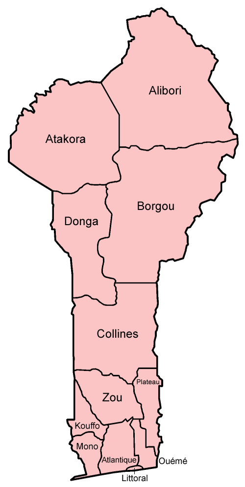
Benin is divided into twelve departments (French: départements) which are subdivided into 77 communes. In 1999, the previous six departments were each split into two-halves, forming the later twelve.
Military
Demographics
The majority of Benin's 11,485,000 inhabitants live in the south of the country. The life expectancy is 62 years. About 42 African ethnic groups live in this country, including the Yoruba in the southeast (migrated from Nigeria in the 12th century); the Dendi in the north-central area (who came from Mali in the 16th century); the Bariba and the Fula in the northeast; the Betammaribe and the Somba in the Atakora Mountains; the Fon in the area around Abomey in the South Central and the Mina, Xueda, and Aja (who came from Togo) on the coast.
The personnel of European embassies and foreign aid missions and of nongovernmental organisations and missionary groups account for a part of the 5,500 European population.
Non-Africans include Europeans, Lebanese people and South Asians.
Language
Local languages are used as the many languages of instruction in elementary schools, with French introduced in later years. At the secondary school level, French is the sole language of instruction. Beninese languages are "generally transcribed" with a separate letter for each speech sound (phoneme), rather than using diacritics as in French or digraphs as in English. This includes Beninese Yoruba, which in Nigeria is written with both diacritics and digraphs. For instance, the mid vowels written é, è, ô, o in French are written e, ɛ, o, ɔ in Beninese languages, whereas the consonants that are written ng and sh or ch in English are written ŋ and c. Digraphs are used for nasal vowels and the labial-velar consonants kp and gb, as in the name of the Fon language Fon gbe /fõ ɡ͡be/, and diacritics are used as tone marks. In French-language publications, a mixture of French and Beninese orthographies may be seen.
Religion
The two main religions in Benin are Christianity, followed mostly in the south and center, and Islam, brought by the Songhai Empire and Hausa merchants and followed in Alibori, Borgou, and Donga provinces, as well as among the Yoruba, who also practice Christianity. Some continue to hold Vodun and Orisha beliefs and have incorporated the pantheon of Vodun and Orisha into Christianity. Ahmadiyya, a sect of Islam originating in the 19th century, also has a presence in the country.
In the 2013 census, 48.5% of the population of Benin were Christian (25.5% Roman Catholic, 6.7% Celestial Church of Christ, 3.4% Methodist, and 12.9% other Christian denominations), 27.7% were Muslim, 11.6% practiced Vodun, 2.6% practiced other local traditional religions, 2.6% practiced other religions, and 5.8% claimed no religious affiliation. A government survey conducted by the Demographic and Health Surveys Program in 2011–2012 indicated that followers of Christianity comprised 57.5% of the population (with Catholics making up 33.9%, Methodists 3.0%, Celestials 6.2% and other Christians 14.5%), while Muslims were 22.8%.
According to the most recent (2020) estimate, the population of Benin was 52.2% Christian, 24.6% Muslim, 17.9% animist, and 5.3% other faiths or no religion.
Traditional religions include local animistic religions in the Atakora region and Vodun and Orisha veneration among the Yoruba and Tado peoples in the center and south of the nation. The town of Ouidah on the central coast is the spiritual center of Beninese Vodun or Voodoo.
Education
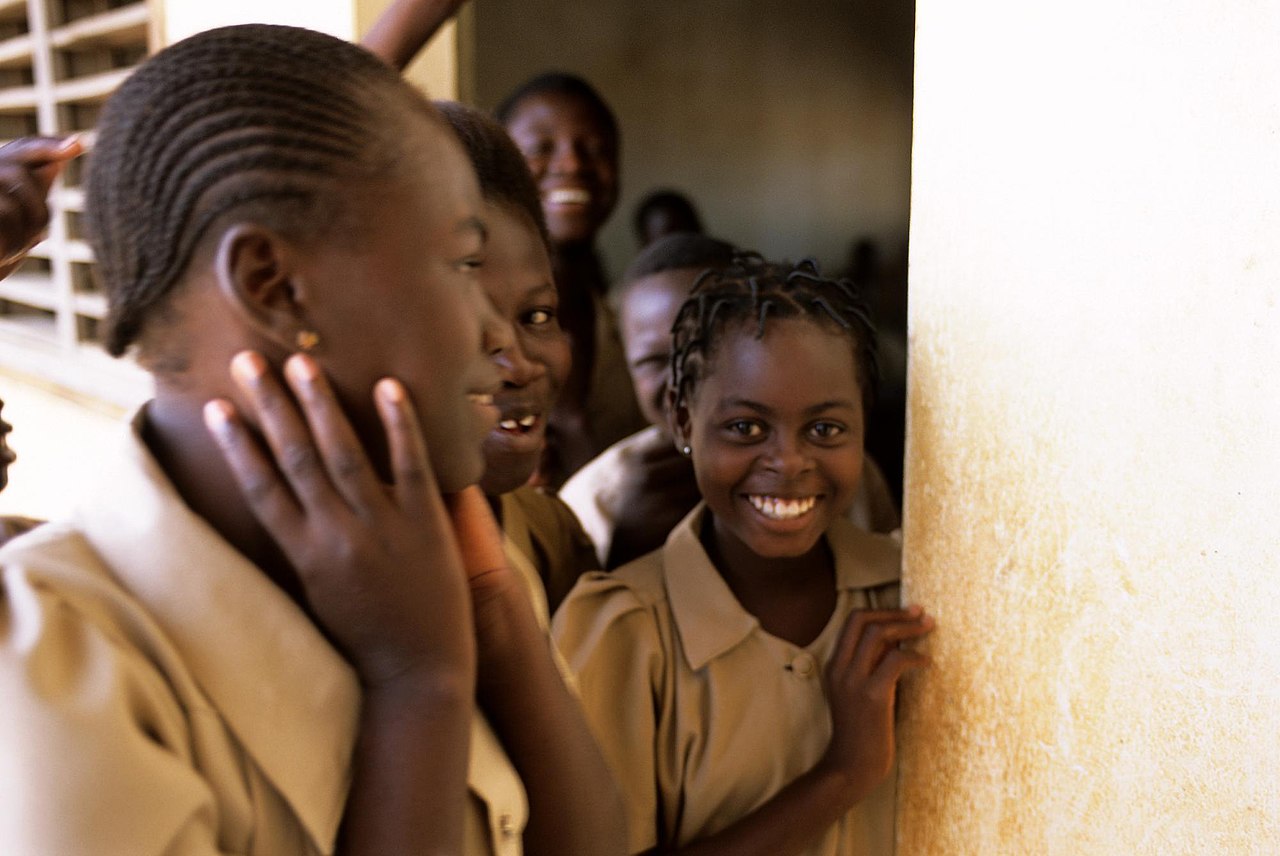
The literacy rate in 2015 was estimated to be 38.4% (49.9% for males and 27.3% for females). Benin has achieved universal primary education and half of the children (54%) were enrolled in secondary education in 2013, according to the UNESCO Institute for Statistics.