
The Arctic Ocean is the smallest and shallowest of the world's five oceanic divisions. It spans an area of approximately 14,060,000 km2 (5,430,000 sq mi) and is the coldest of the world's oceans. The International Hydrographic Organization (IHO) recognizes it as an ocean, although some oceanographers call it the Arctic Mediterranean Sea or North Polar Sea. It has also been described as an estuary of the Atlantic Ocean. It is also seen as the northernmost part of the all-encompassing world ocean.
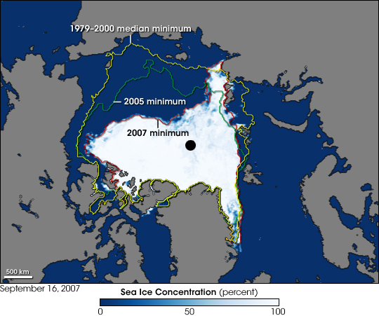
The Arctic Ocean includes the North Pole region in the middle of the Northern Hemisphere and extends south to about 60°N. The Arctic Ocean is surrounded by Eurasia and North America, and the borders follow topographic features: the Bering Strait on the Pacific side and the Greenland Scotland Ridge on the Atlantic side. It is mostly covered by sea ice throughout the year and almost completely in winter. The Arctic Ocean's surface temperature and salinity vary seasonally as the ice cover melts and freezes; its salinity is the lowest on average of the five major oceans, due to low evaporation, heavy fresh water inflow from rivers and streams, and limited connection and outflow to surrounding oceanic waters with higher salinities. The summer shrinking of the ice has been quoted at 50%.The US National Snow and Ice Data Center (NSIDC) uses satellite data to provide a daily record of Arctic sea ice cover and the rate of melting compared to an average period and specific past years, showing a continuous decline in sea ice extent. In September 2012, the Arctic ice extent reached a new record minimum. Compared to the average extent (1979–2000), the sea ice had diminished by 49%.
History
North America
Human habitation in the North American polar region goes back at least 17,000–50,000 years, during the Wisconsin glaciation. Falling sea levels allowed people to move across the Bering land bridge that joined Siberia to northwestern North America (Alaska), leading to the Settlement of the Americas.

Early Paleo-Eskimo groups included the Pre-Dorset (c. 3200–850 BC); the Saqqaq culture of Greenland (2500–800 BC); the Independence I and Independence II cultures of northeastern Canada and Greenland (c. 2400–1800 BC and c. 800–1 BC); and the Groswater of Labrador and Nunavik. The Dorset culture spread across Arctic North America between 500 BC and AD 1500. The Dorset were the last major Paleo-Eskimo culture in the Arctic before the migration east from present-day Alaska of the Thule people, ancestors of the modern Inuit.
The Thule Tradition lasted from about 200 BC to AD 1600, arising around the Bering Strait and later encompassing almost the entire Arctic region of North America. The Thule people were the ancestors of the Inuit, who now live in Alaska, Northwest Territories, Nunavut, Nunavik (northern Quebec), Labrador and Greenland.
Europe
For much of European history, the north polar regions remained largely unexplored and their geography conjectural. Pytheas of Massilia recorded an account of a journey northward in 325 BC, to a land he called "Eschate Thule", where the Sun only set for three hours each day and the water was replaced by a congealed substance "on which one can neither walk nor sail". He was probably describing loose sea ice known today as "growlers" or "bergy bits"; his "Thule" was probably Norway, though the Faroe Islands or Shetland have also been suggested.
Due to the limited information available at the time, early cartographers were unsure how to represent the regions around the North Pole, with some including regions of land (as in Johannes Ruysch's map of 1507, or Gerardus Mercator's map of 1595) or representing the entire region as water (as with Martin Waldseemüller's world map of 1507). The few expeditions to penetrate much beyond the Arctic Circle in that era added only small islands, such as Novaya Zemlya (11th century) and Spitzbergen (1596). From the late 16th to the early 20th century, expeditions to the Arctic Ocean became more common (see List of Arctic expeditions), often in search of trade routes from Europe to the Pacific Ocean, and so the geographical knowledge of the region gradually improved.
19th century
The lack of knowledge of what lay north of the shifting barrier of ice gave rise to a number of conjectures. In England and other European nations, the myth of an "Open Polar Sea" was persistent. John Barrow, longtime Second Secretary of the British Admiralty, promoted exploration of the region from 1818 to 1845 in search of this.
In the United States in the 1850s and 1860s, the explorers Elisha Kane and Isaac Israel Hayes both claimed to have seen part of this elusive body of water. Even quite late in the century, the eminent authority Matthew Fontaine Maury included a description of the Open Polar Sea in his textbook The Physical Geography of the Sea (1883). Nevertheless, as all the explorers who travelled closer and closer to the pole reported, the polar ice cap is quite thick and persists year-round, and the open polar sea theory was widely considered to be disproven by the early 1900s.
Fridtjof Nansen was the first to make a nautical crossing of the Arctic Ocean, in the Fram Expedition from 1893 to 1896.
20th century
The first surface crossing of the ocean was led by Wally Herbert in 1969, in a dog sled expedition from Alaska to Svalbard, with air support. The first nautical transit of the north pole was made in 1958 by the submarine USS Nautilus, and the first surface nautical transit occurred in 1977 by the icebreaker NS Arktika.
Since 1937, Soviet and Russian manned drifting ice stations have extensively monitored the Arctic Ocean. Scientific settlements were established on the drift ice and carried thousands of kilometres by ice floes.

In World War II, the European region of the Arctic Ocean was heavily contested: the Allied commitment to resupply the Soviet Union via its northern ports was opposed by German naval and air forces.
In 1954 Scandinavian Airlines (SAS) established the first commercial flights over the Arctic Ocean, between Los Angeles and Copenhagen.
21st century
In August 2019, US President Donald Trump suggested buying Greenland. He raised the idea firmly in December 2024, saying ownership of Greenland was necessary for the national security and economic interests of the United States. He has said the use of force is not ruled out. In a December 10, 2024, social media post, President-elect Trump referred to the prime minister of Canada as the governor of a purported 51st state. Previously he had said that annexation of Canada might be preferable from a trade point of view. On February 1, 2025, he began a trade war.
During a telephone call with new Canadian Prime Minister Mark Carney on March 28, 2025, Trump raised the idea of Canada becoming the 51st U.S. state and described his view of the advantages of annexation. In various other comments, formal and informal, he has expressed a desire to control Canada's resources and the Canadian Internal Waters of the Arctic, commonly known as the Northwest Passage.
Geography
Size
The Arctic Ocean occupies a roughly circular basin and covers an area of about 14,056,000 km2 (5,427,000 sq mi), almost the size of Antarctica. The coastline is 45,390 km (28,200 mi) long. It is the only ocean smaller than Russia, which has a land area of 17,098,246 km2 (6,601,670 sq mi).
Surrounding land and exclusive economic zones
The Arctic Ocean is surrounded by the land masses of Eurasia (Russia and Norway), North America (Canada and the U.S. state of Alaska), Greenland, and Iceland.
Note: Some parts of the areas listed in the table are located in the Atlantic Ocean. Other consists of Gulfs, Straits, Channels and other parts without specific names and excludes Exclusive Economic Zones.
Subareas and connections
The Arctic Ocean is connected to the Pacific Ocean by the Bering Strait and to the Atlantic Ocean through the Greenland Sea and Labrador Sea. (The Iceland Sea is sometimes considered part of the Greenland Sea, and sometimes separate.)
The largest seas in the Arctic Ocean:
Different authorities put various marginal seas in either the Arctic Ocean or the Atlantic Ocean, including: Hudson Bay,
Baffin Bay, the Norwegian Sea, and Hudson Strait.
Islands
The main islands and archipelagos in the Arctic Ocean are, from the prime meridian west:
Jan Mayen (Norway)
Iceland
Greenland
Arctic Archipelago (Canada, includes the Queen Elizabeth Islands and Baffin Island)
Wrangel Island (Russia)
New Siberian Islands (Russia)
Severnaya Zemlya (Russia)
Novaya Zemlya (Russia, includes Severny Island and Yuzhny Island)
Franz Josef Land (Russia)
Svalbard (Norway, including Bear Island)
Ports
There are several ports and harbours on the Arctic Ocean.
Alaska
Utqiaġvik (Barrow)
Prudhoe Bay
Canada
Manitoba: Churchill (Port of Churchill)
Nunavut: Nanisivik (Nanisivik Naval Facility)
Tuktoyaktuk and Inuvik in the Northwest Territories
Greenland: Nuuk (Nuuk Port and Harbour)
Norway
Mainland: Kirkenes and Vardø
Svalbard: Longyearbyen
Iceland
Akureyri