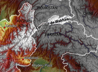
The Wakhan Corridor is a protruding strip of territory that is part of the Wakhan District in the Badakhshan Province of Afghanistan. It begins in Afghanistan's northeastern corner and stretches eastward, connecting the country to the Xinjiang Uygur Autonomous Region within China. The strip narrowly separates the Badakhshan Mountainous Autonomous Region in Tajikistan from Khyber Pakhtunkhwa in Pakistan as well as Pakistani-administered Gilgit–Baltistan. This high mountain valley, which rises to a maximum altitude of 4,923 m (16,152 ft), serves as the source of both the Panj and Pamir rivers, which converge to form the larger Amu Darya River. For countless centuries, a vital trade route has traversed this valley, facilitating the movement of travelers to and from East, South, and Central Asia.
Key Facts
| Subject | Wakhan Corridor |
| Category | Narrow strip of land in Afghanistan |
| Reading time | 1 min · Advanced |
| Key date | 923 |
People Mentioned
Reading level
Audio Summary
Played with your browser's voice. Studio-quality audio can be added with a text-to-speech service.
Ask about this article
📝 Quick Quiz1 / 3
What is "Wakhan Corridor" primarily known for?
Vocix Daily — In Your Inbox
Top stories, deep-dive articles, and "On This Day" history — one crisp digest delivered every morning.
Sources & references
Reference material for this entry is drawn from the open encyclopedic record, including Wikipedia , available under the CC BY-SA 4.0 license. Images are credited individually beside each photo.