
Tikal (; Tik'al in modern Mayan orthography) is the ruin of an ancient city, which was likely to have been called Yax Mutal, found in a rainforest in Guatemala. It is one of the largest archaeological sites and urban centers of the pre-Columbian Maya civilization. It is located in the archaeological region of the Petén Basin in what is now the Petén Department in northern Guatemala. The site is part of Guatemala's Tikal National Park, which was declared a UNESCO World Heritage Site in 1979.
Tikal was the capital of a state that became one of the most powerful kingdoms of the ancient Maya. Though monumental architecture at the site dates back as far as the 4th century BC, Tikal reached its apogee during the Classic Period, c. 200 to 900. During this time, the city dominated much of the Maya region politically, economically, and militarily, while interacting with areas throughout Mesoamerica such as the great metropolis of Teotihuacan in the distant Valley of Mexico. There is evidence that one of Tikal's great ruling dynasties was founded by conquerors from Teotihuacan in the 4th century AD. Following the end of the Late Classic Period, no new major monuments were built at Tikal and there is evidence that elite palaces were burned. These events were coupled with a gradual population decline, culminating with the site's abandonment by the end of the 10th century.
Tikal is the best understood of any of the large lowland Maya cities, with a long dynastic ruler list, the discovery of the tombs of many of the rulers on this list and the investigation of their monuments, temples and palaces.

After centuries of abandonment, the site was first explored in the modern era in 1848. Tikal National Park was established in 1955, protecting the site and 570 square kilometers (220 sq mi) of surrounding tropical forests, savannas, and wetlands within the Maya Biosphere Reserve.
Etymology
The name Tikal may be derived from ti ak'al in the Yucatec Maya language; it is said to be a relatively modern name meaning 'at the waterhole'. The name was apparently applied to one of the site's ancient reservoirs by hunters and travelers in the region. It has alternatively been interpreted as meaning 'the place of the voices' in the Itzaʼ Maya language. Tikal, however, is not the ancient name for the site but rather the name adopted shortly after its discovery in the 1840s. Hieroglyphic inscriptions at the ruins refer to the ancient city as Yax Mutal or Yax Mutul, meaning 'First Mutal'. Tikal may have come to have been called this because Dos Pilas also came to use the same emblem glyph; the rulers of the city presumably wanted to distinguish themselves as the first city to bear the name.
The kingdom as a whole was simply called Mutul, which is the reading of the "hair bundle" emblem glyph seen in the accompanying photo. Its precise meaning remains obscure.

Geography
The closest large modern settlements are Flores and Santa Elena, approximately 64 kilometers (40 mi) by road to the southwest. Tikal is approximately 303 kilometers (188 mi) north of Guatemala City. It is 19 kilometers (12 mi) south of the contemporary Maya city of Uaxactun and 30 kilometers (19 mi) northwest of Yaxha. The city was located 100 kilometers (62 mi) southeast of its great Classic Period rival, Calakmul, and 85 kilometers (53 mi) northwest of Calakmul's ally Caracol, now in Belize.
The city has been completely mapped and covered an area greater than 16 square kilometers (6.2 sq mi) that included about 3,000 structures. The topography of the site consists of a series of parallel limestone ridges rising above swampy lowlands. The major architecture of the site is clustered upon areas of higher ground and linked by raised causeways spanning the swamps. The area around Tikal has been declared as the Tikal National Park and the preserved area covers 570 square kilometers (220 sq mi). It was created on 26 May 1955 under the auspices of the Instituto de Antropología e Historia and was the first protected area in Guatemala.
The ruins lie among the tropical rainforests of northern Guatemala that formed the cradle of lowland Maya civilization. The city itself was located among abundant fertile upland soils, and may have dominated a natural east–west trade route across the Yucatán Peninsula. Conspicuous trees at the Tikal park include gigantic Kapok tree (Ceiba pentandra) the sacred tree of the Maya; tropical cedar (Cedrela odorata), and Honduras mahogany (Swietenia macrophylla). Regarding the fauna, agoutis, white-nosed coatis, gray foxes, Geoffroy's spider monkeys, howler monkeys, harpy eagles, falcons, ocellated turkeys, guans, toucans, green parrots and leafcutter ants can be seen there regularly. Jaguars, ocelots, and cougars are also said to roam in the park.
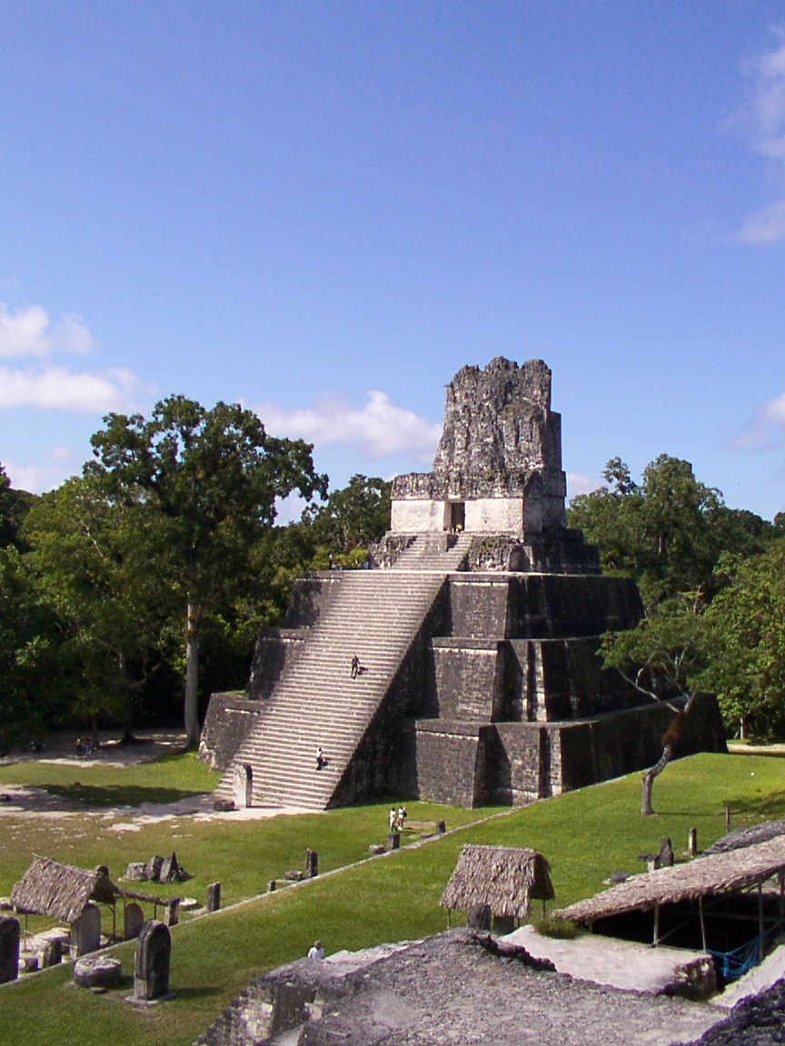
Tikal had no water other than what was collected from rainwater and stored in ten reservoirs. Archaeologists working in Tikal during the 20th century refurbished one of these ancient reservoirs to store water for their own use. The average annual rainfall at Tikal is 1,945 millimeters (76.6 in). However, the arrival of rain was often unpredictable, and long periods of drought could occur before the crops ripened, which severely threatened the inhabitants of the city.
Population
Population estimates for Tikal vary from 10,000 to as high as 90,000 inhabitants. The population of Tikal began a continuous curve of growth starting in the Preclassic Period (approximately 2000 BC – AD 200), with a peak in the Late Classic with the population growing rapidly from AD 700 through to 830, followed by a sharp decline. For the 120 square kilometers (46 sq mi) area falling within the earthwork defenses of the hinterland, the peak population is estimated at 517 per square kilometer (1340 per square mile). In an area within a 12 kilometers (7.5 mi) radius of the site core, peak population is estimated at 120,000; population density is estimated at 265 per square kilometer (689 per square mile). In a region within a 25 kilometers (16 mi) radius of the site core and including some satellite sites, peak population is estimated at 425,000 with a density of 216 per square kilometer (515 per square mile). These population figures are even more impressive because of the extensive swamplands that were unsuitable for habitation or agriculture. However, some archaeologists, such as David Webster, believe these figures to be far too high.
History
Preclassic
There are traces of early agriculture at the site dating as far back as 1000 BC, in the Middle Preclassic. A cache of Mamon ceramics dating from about 700–400 BC were found in a sealed chultun, a subterranean bottle-shaped chamber.
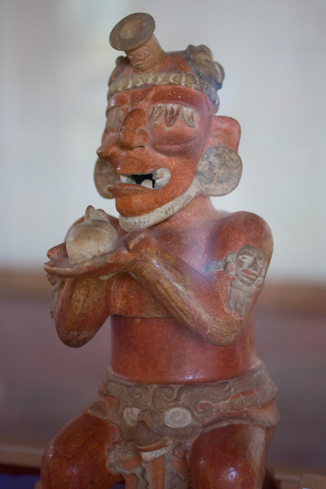
Major construction at Tikal was already taking place in the Late Preclassic period, first appearing around 400–300 BC, including the building of major pyramids and platforms, although the city was still dwarfed by sites further north such as El Mirador and Nakbe. At this time, Tikal participated in the widespread Chikanel culture that dominated the Central and Northern Maya areas at this time – a region that included the entire Yucatán Peninsula including northern and eastern Guatemala and all of Belize.
Two temples dating to Late Chikanel times had masonry-walled superstructures that may have been corbel-vaulted, although this has not been proven. One of these had elaborate paintings on the outer walls showing human figures against a scrollwork background, painted in yellow, black, pink and red.
In the 1st century AD, rich burials first appeared and Tikal underwent a political and cultural florescence as its giant northern neighbors declined. At the end of the Late Preclassic, the Izapan style art and architecture from the Pacific Coast began to influence Tikal, as demonstrated by a broken sculpture from the acropolis and early murals at the city.
Early Classic
Dynastic rulership among the lowland Maya is most deeply rooted at Tikal. According to later hieroglyphic records, the dynasty was founded by Yax Ehb Xook, perhaps in the 1st century AD. At the beginning of the Early Classic, power in the Maya region was concentrated at Tikal and Calakmul, in the core of the Maya heartland.
Tikal may have benefited from the collapse of the large Preclassic states such as El Mirador. In the Early Classic Tikal rapidly developed into the most dynamic city in the Maya region, stimulating the development of other nearby Maya cities.
The site, however, was often at war and inscriptions tell of alliances and conflict with other Maya states, including Uaxactun, Caracol, Naranjo and Calakmul. The site was defeated at the end of the Early Classic by Caracol, which rose to take Tikal's place as the paramount center in the southern Maya lowlands. The earlier part of the Early Classic saw hostilities between Tikal and its neighbor Uaxactun, with Uaxactun recording the capture of prisoners from Tikal.

There appears to have been a breakdown in the male succession by AD 317, when Lady Unen Bahlam conducted a Kʼatun-ending ceremony, apparently as queen of the city.
Tikal and Teotihuacan
As early as 200 AD, Teotihuacan had embassies in Tikal.
The fourteenth king of Tikal was Chak Tok Ichʼaak (Great Jaguar Paw). Chak Tok Ichʼaak built a palace that was preserved and developed by later rulers until it became the core of the Central Acropolis. Little is known about Chak Tok Ichʼaak except that he was killed on 14 January 378 AD. On the same day, Siyaj Kʼakʼ (Fire Is Born) arrived from the west, having passed through El Peru, a site to the west of Tikal, on 8 January. On Stela 31 he is named as "Lord of the West". Siyaj Kʼakʼ was probably a foreign general serving a figure represented by a non-Maya hieroglyph of a spearthrower combined with an owl, a glyph that is well known from the great metropolis of Teotihuacan in the distant Valley of Mexico. Spearthrower Owl may even have been the ruler of Teotihuacan. These recorded events strongly suggest that Siyaj Kʼakʼ led a Teotihuacan invasion that defeated the native Tikal king, who was captured and immediately executed. Siyaj Kʼakʼ appears to have been aided by a powerful political faction at Tikal itself; roughly at the time of the conquest, a group of Teotihuacan natives were apparently residing near the Lost World complex. He also exerted control over other cities in the area, including Uaxactun, where he became king, but did not take the throne of Tikal for himself. Within a year, the son of Spearthrower Owl by the name of Yax Nuun Ahiin I (First Crocodile) had been installed as the fifteenth king of Tikal while he was still a boy, being enthroned on 13 September 379. He reigned for 47 years as king of Tikal, and remained a vassal of Siyaj Kʼakʼ for as long as the latter lived. It seems likely that Yax Nuun Ayiin I took a wife from the preexisting, defeated, Tikal dynasty and thus legitimized the right to rule of his son, Siyaj Chan Kʼawiil II.
Río Azul, a small site 100 kilometers (62 mi) northeast of Tikal, was conquered by the latter during the reign of Yax Nuun Ayiin I. The site became an outpost of Tikal, shielding it from hostile cities further north, and also became a trade link to the Caribbean.
Although the new rulers of Tikal were foreign, their descendants were rapidly Mayanized. Tikal became the key ally and trading partner of Teotihuacan in the Maya lowlands. After being conquered by Teotihuacan, Tikal rapidly dominated the northern and eastern Peten. Uaxactun, together with smaller towns in the region, were absorbed into Tikal's kingdom. Other sites, such as Bejucal and Motul de San José near Lake Petén Itzá became vassals of their more powerful neighbor to the north. By the middle of the 5th century, Tikal had a core territory of at least 25 kilometers (16 mi) in every direction.
Around the 5th century, an impressive system of fortifications consisting of ditches and earthworks was built along the northern periphery of Tikal's hinterland, joining up with the natural defenses provided by large areas of swampland lying to the east and west of the city. Additional fortifications were probably also built to the south. These defenses protected Tikal's core population and agricultural resources, encircling an area of approximately 120 square kilometers (46 sq mi). Recent research suggests that the earthworks served as a water collection system rather than a defensive purpose.
Tikal and Copán
In the 5th century, the power of the city reached as far south as Copán, whose founder Kʼinich Yax Kʼukʼ Moʼ was clearly connected with Tikal. Copán itself was not in an ethnically Maya region and the founding of the Copán dynasty probably involved the direct intervention of Tikal. Kʼinich Yax Kukʼ Moʼ arrived in Copán in December 426, and bone analysis of his remains shows that he passed his childhood and youth at Tikal. An individual known as Ajaw Kʼukʼ Mo' (lord Kʼukʼ Moʼ) is referred to in an early text at Tikal and may well be the same person. His tomb had Teotihuacan characteristics and he was depicted in later portraits dressed in the warrior garb of Teotihuacan. Hieroglyphic texts refer to him as "Lord of the West", much like Siyaj Kʼakʼ. At the same time, in late 426, Copán founded the nearby site of Quiriguá, possibly sponsored by Tikal itself. The founding of these two centers may have been part of an effort to impose Tikal's authority upon the southeastern portion of the Maya region. The interaction between these sites and Tikal was intense over the next three centuries.
A long-running rivalry between Tikal and Calakmul began in the 6th century, with each of the two cities forming its own network of mutually hostile alliances arrayed against each other in what has been likened to a long-running war between two Maya superpowers. The kings of these two capitals adopted the title kaloomteʼ, a term that has not been precisely translated but that implies something akin to "high king".
The early 6th century saw another queen ruling the city, known only as the "Lady of Tikal", who was very likely a daughter of Chak Tok Ichʼaak II. She seems never to have ruled in her own right, rather being partnered with male co-rulers. The first of these was Kaloomteʼ Bahlam, who seems to have had a long career as a general at Tikal before becoming co-ruler and 19th in the dynastic sequence. The Lady of Tikal herself seems not have been counted in the dynastic numbering. It appears she was later paired with lord "Bird Claw", who is presumed to be the otherwise unknown 20th ruler.
Late Classic
Tikal hiatus
In the mid-6th century, Caracol seems to have allied with Calakmul and defeated Tikal, closing the Early Classic. The "Tikal hiatus" refers to a period between the late 6th to late 7th century where there was a lapse in the writing of inscriptions and large-scale construction at Tikal. In the latter half of the 6th century AD, a serious crisis befell the city, with no new stelae being erected and with widespread deliberate mutilation of public sculpture. This hiatus in activity at Tikal was long unexplained until later epigraphic decipherments identified that the period was prompted by Tikal's comprehensive defeat at the hands of Calakmul and the Caracol polity in AD 562, a defeat that seems to have resulted in the capture and sacrifice of the king of Tikal. The badly eroded Altar 21 at Caracol described how Tikal suffered this disastrous defeat in a major war in April 562. It seems that Caracol was an ally of Calakmul in the wider conflict between that city and Tikal, with the defeat of Tikal having a lasting impact upon the city. Tikal was not sacked but its power and influence were broken. After its great victory, Caracol grew rapidly and some of Tikal's population may have been forcibly relocated there. During the hiatus period, at least one ruler of Tikal took refuge with Janaabʼ Pakal of Palenque, another of Calakmul's victims. Calakmul itself thrived during Tikal's long hiatus period.
The beginning of the Tikal hiatus has served as a marker by which archaeologists commonly subdivide the Classic period of Mesoamerican chronology into the Early and Late Classic.
Tikal and Dos Pilas
In 629, Tikal founded Dos Pilas, some 110 kilometers (68 mi) to the southwest, as a military outpost in order to control trade along the course of the Pasión River. Bʼalaj Chan Kʼawiil was installed on the throne of the new outpost at the age of four, in 635. When he was older, for many years he served as a loyal vassal fighting for his brother, the king of Tikal. Roughly twenty years later, Dos Pilas was attacked by Calakmul and was soundly defeated. Bʼalaj Chan Kʼawiil was captured by the king of Calakmul but, instead of being sacrificed, he was re-instated on his throne as a vassal of his former enemy.
He attacked Tikal in 657, forcing Nuun Ujol Chaak, then king of Tikal, to temporarily abandon the city. The first two rulers of Dos Pilas continued to use the Mutal emblem glyph of Tikal, and they probably felt that they had a legitimate claim to the throne of Tikal itself. For some reason, Bʼalaj Chan Kʼawiil was not installed as the new ruler of Tikal; instead he stayed at Dos Pilas. Tikal counterattacked against Dos Pilas in 672, driving Bʼalaj Chan Kʼawiil into an exile that lasted five years. Calakmul tried to encircle Tikal within an area dominated by its allies, such as El Peru, Dos Pilas, and Caracol.
In 682, Jasaw Chan Kʼawiil I erected the first dated monument at Tikal in 120 years and claimed the title of kaloomteʼ, so ending the hiatus. He initiated a program of new construction and turned the tables on Calakmul when, in 695, he captured the enemy noble and threw the enemy state into a long decline from which it never fully recovered. After this, Calakmul never again erected a monument celebrating a military victory.
Tikal after Teotihuacan
By the 7th century, there was no active Teotihuacan presence at any Maya site and the center of Teotihuacan had been razed by 700. Even after this, formal war attire illustrated on monuments was Teotihuacan style. Jasaw Chan Kʼawiil I and his heir Yikʼin Chan Kʼawiil continued hostilities against Calakmul and its allies and imposed firm regional control over the area around Tikal, extending as far as the territory around Lake Petén Itzá. These two rulers were responsible for much of the impressive architecture visible today.
In 738, Quiriguá, a vassal of Copán, Tikal's key ally in the south, switched allegiance to Calakmul, defeated Copán and gained its own independence. It appears that this was a conscious effort on the part of Calakmul to bring about the collapse of Tikal's southern allies. This upset the balance of power in the southern Maya area and lead to a steady decline in the fortunes of Copán.
In the 8th century, the rulers of Tikal collected monuments from across the city and erected them in front of the North Acropolis. By the late 8th century and early 9th century, activity at Tikal slowed. Impressive architecture was still built but few hieroglyphic inscriptions refer to later rulers.
Terminal Classic
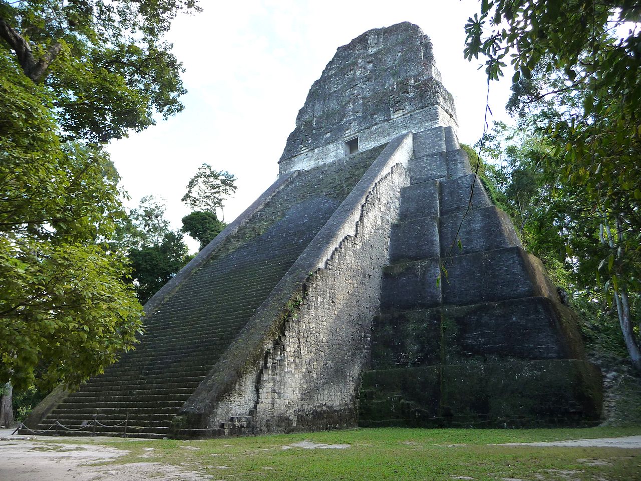
By the 9th century, the crisis of the Classic Maya collapse was sweeping across the region, with populations plummeting and city after city falling into silence. Increasingly endemic warfare in the Maya region caused Tikal's supporting population to heavily concentrate close to the city itself, accelerating the use of intensive agriculture and the corresponding environmental decline. Construction continued at the beginning of the century, with the erection of Temple 3, the last of the city's major pyramids, and the erection of monuments to mark the 19th Kʼatun in 810. The beginning of the 10th Bakʼtun in 830 passed uncelebrated, and marks the beginning of a 60-year hiatus, probably resulting from the collapse of central control in the city. During this hiatus, satellite sites traditionally under Tikal's control began to erect their own monuments featuring local rulers and using the Mutal emblem glyph, with Tikal apparently lacking the authority or the power to crush these bids for independence. In 849, Jewel Kʼawiil is mentioned on a stela at Seibal as visiting that city as the Divine Lord of Tikal but he is not recorded elsewhere and Tikal's once-great power was little more than a memory. The sites of Ixlu and Jimbal had by now inherited the once exclusive Mutal emblem glyph.
As Tikal and its hinterland reached peak population, the area suffered deforestation, soil erosion and nutrient loss followed by a rapid decline in population levels. Recent analysis also indicates that the city's freshwater sources became highly contaminated with mercury, phosphate and cyanobacteria leading to the accumulation of toxins. Tikal and its immediate surroundings seem to have lost most of their population between 830 and 950 and central authority seems to have collapsed rapidly. There is not much evidence from Tikal that the city was directly affected by the endemic warfare that afflicted parts of the Maya region during the Terminal Classic, although an influx of refugees from the Petexbatún region may have exacerbated problems resulting from the already stretched environmental resources.
In the latter half of the 9th century, there was an attempt to revive royal power at the much-diminished city of Tikal, as evidenced by a stela erected in the Great Plaza by Jasaw Chan Kʼawiil II in 869. This was the last monument erected at Tikal before the city finally fell into silence. The former satellites of Tikal, such as Jimbal and Uaxactun, did not last much longer, erecting their final monuments in 889. By the end of the 9th century, the vast majority of Tikal's population had deserted the city, its royal palaces were occupied by squatters and simple thatched dwellings were being erected in the city's ceremonial plazas. The squatters blocked some doorways in the rooms they reoccupied in the monumental structures of the site and left rubbish that included a mixture of domestic refuse and non-utilitarian items such as musical instruments. These inhabitants reused the earlier monuments for their own ritual activities, far removed from those of the royal dynasty that had erected them. Some monuments were vandalized and some were moved to new locations. Before its final abandonment all respect for the old rulers had disappeared, with the tombs of the North Acropolis being explored for jade and the easier-to-find tombs were looted. After 950, Tikal was all but deserted, although a remnant population may have survived in perishable huts interspersed among the ruins. Even these final inhabitants abandoned the city in the 10th or 11th centuries and the rainforest claimed the ruins for the next thousand years. Some of Tikal's population may have migrated to the Peten Lakes region, which remained heavily populated in spite of a plunge in population levels in the first half of the 9th century.
The most likely cause of collapse at Tikal is overpopulation and agrarian failure. The fall of Tikal was a blow to the heart of Classic Maya civilization, the city having been at the forefront of courtly life, art and architecture for over a thousand years, with an ancient ruling dynasty. However, new research regarding paleoenvironmental proxies from the Tikal reservoir system suggests that a meteorological drought may have led to the abandonment of Tikal, fouling some reservoirs near the temple and palace with algae blooms, while other reservoirs remained drinkable. Buildings were painted with mercury-bearing cinnabar, which were washed off by rain and polluted some reservoirs.
Works of Kohler and colleagues showed that this city reached an unsustainable level of inequalities at the end.
Rulers
Modern history
In 1525, the Spanish conquistador Hernán Cortés passed within a few kilometers of the ruins of Tikal but did not mention them in his letters. After Spanish friar Andrés de Avendaño became lost in the Petén forests in early 1696 he described a ruin that may well have been Tikal.
As is often the case with huge ancient ruins, knowledge of the site was never completely lost in the region. It seems that local people never forgot about Tikal and they guided Guatemalan expeditions to the ruins in the 1850s. Some second- or third-hand accounts of Tikal appeared in print starting in the 17th century, continuing through the writings of John Lloyd Stephens in the early 19th century (Stephens and his illustrator Frederick Catherwood heard rumors of a lost city, with white building tops towering above the jungle, during their 1839–40 travels in the region). Because of the site's remoteness from modern towns, however, no explorers visited Tikal until Modesto Méndez and Ambrosio Tut, respectively the commissioner and the governor of Petén, visited it in 1848. Artist Eusebio Lara accompanied them and their account was published in Germany in 1853. Several other expeditions came to further investigate, map, and photograph Tikal in the 19th century (including Alfred P. Maudslay in 1881–82) and the early 20th century. Pioneering archaeologists started to clear, map and record the ruins in the 1880s.
In 1951, a small airstrip was built at the ruins, which previously could only be reached by several days' travel through the jungle on foot or mule. Tikal National Park was established on May 26, 1955 under government decree by the Ministry of Education, via the Instituto de Antropología e Historia, advised by Dr. Adolfo Molina Orantes and under the government of Carlos Castillo Armas.
From 1956 to 1970 the University of Pennsylvania's Tikal Project mapped the city on a scale not previously seen in the Maya area and carried out major archaeological excavations to restore many of the structures. Excavations directed by Edwin M. Shook and later by William Coe of the university investigated the North Acropolis and the Central Plaza from 1957 to 1969. The Tikal Project recorded over 200 monuments at the site. In 1979, the Guatemalan government began a further archaeological project at Tikal, which continued through to 1984.
Filmmaker George Lucas used Tikal as a filming location for the fictional moon Yavin 4 in the first Star Wars film, which premiered in 1977. Subsequent Star Wars movie Rogue One (2016) and season 2 of TV series Andor (2025) were also filmed at Tikal for the same fictional location.