
The Rhine ( RYNE) is one of the major rivers of Europe. The river begins in the Swiss canton of Graubünden in the southeastern Swiss Alps. It forms part of the Swiss–Liechtenstein border, then part of the Swiss–Austrian border. From Lake Constance downstream, it forms part of the Swiss–German border. After that, the Rhine defines much of the Franco-German border. It then flows in a mostly northerly direction through the German Rhineland. Finally, the Rhine turns to flow predominantly west to enter the Netherlands, eventually emptying into the North Sea. It drains an area of 185,000 km2.
Its name derives from the Gaulish Rēnos. There are two German states named after the river, North Rhine-Westphalia and Rhineland-Palatinate, in addition to several districts (e.g. Rhein-Sieg). The departments of Bas-Rhin and Haut-Rhin in Alsace (France) are also named after the river. Some adjacent towns are named after it, such as Rheinau, Stein am Rhein, Rheineck, Rheinfelden (Switzerland) and Rheinfelden (Germany).
The International Commission for the Hydrology of the Rhine Basin (CHR) and EUWID contend that the river could experience a massive decrease in volume, or even dry up completely in case of drought, within the next 30 to 80 years, as a result of the climate crisis.

The Rhine is the second-longest river in Central and Western Europe (after the Danube), at about 1,230 km (760 mi), with an average discharge of about 2,900 m3/s (100,000 cu ft/s). It also contains the most powerful waterfall in Europe, the Rhine Falls.
The Rhine and the Danube comprised much of the Roman Empire's northern inland boundary, and the Rhine has been a vital navigable waterway bringing trade and goods deep inland since those days. The various castles and defenses built along it attest to its prominence as a waterway in the Holy Roman Empire. Among the largest and most important cities on the Rhine are Cologne, Rotterdam, Düsseldorf, Duisburg, Strasbourg, Arnhem, and Basel.
Name
The variants of the name of the Rhine (Latin Rhenus; French Rhin, Italian Reno, Romansh Rain or Rein, Dutch Rijn, Alemannic Ry, Ripuarian Rhing) in modern languages are all derived from the Gaulish name Rēnos, which was adapted in Roman-era geography (1st century BC) as Latin Rhenus, and as Greek Ῥῆνος (Rhēnos).

The spelling with Rh- in English Rhine as well as in German Rhein and French Rhin is due to the influence of Greek orthography, while the vocalization -i- is due to the Proto-Germanic adoption of the Gaulish name as *Rīnaz, via Old Frankish giving Old English Rín, Old High German Rīn, early Middle Dutch (c. 1200) Rijn (then also spelled Ryn or Rin).
The modern German diphthong vowel Rhein (also used in Romansh) Rein, Rain is a Central German development of the early modern period, with the Alemannic name Rhi(n) keeping the older vocalism. In Alemannic, the deletion of the ending -n in pausa is a recent development; the form Rhin is largely preserved in Lucernese dialects. Rhing in Ripuarian is diphthongized, as is Rhei, Rhoi in Palatine. While Spanish has adopted the Germanic vocalism Rin-, Italian, Occitan, and Portuguese have retained the Latin Ren-.
The Gaulish name Rēnos (Proto-Celtic or pre-Celtic *Reinos) belongs to a class of river names built from the Proto-Indo-European root *rei- "to move, flow, run", also found in other names such as the Reno in Italy.
The grammatical gender of the Celtic name (as well as of its Greek and Latin adaptation) is masculine, and the name remains masculine in German, Dutch, French, Spanish and Italian. The Old English river name was variously inflected as masculine or feminine; and its Old Icelandic adoption was inflected as feminine.
Geography
The length of the Rhine is conventionally measured in "Rhine-kilometers" (Rheinkilometer), a scale introduced in 1939 that runs from the 0 km datum at Old Rhine Bridge in the city of Konstanz, at the western end of Lake Constance, to the Hook of Holland at 1,036.20 km.
The river is significantly shortened from its natural course due to a number of canal projects completed in the 19th and 20th centuries. The "total length of the Rhine", including of Lake Constance and the Alpine Rhine is more difficult to measure objectively; it was cited as 1,232 kilometers (766 miles) by the Dutch Rijkswaterstaat in 2010.
Its course is conventionally divided as follows:
Headwaters and sources
Anterior Rhine and Posterior Rhine
The source of the river is generally considered north of Lai da Tuma/Tomasee on Rein Anteriur/Vorderrhein, although its southern tributary Rein da Medel is actually longer before its confluence with the Anterior Rhine near Disentis.
The Anterior Rhine (Romansh: Rein Anteriur, German: Vorderrhein) springs from Lai da Tuma/Tomasee, near the Oberalp Pass and passes the impressive Ruinaulta formed by the largest visible rock slide in the alps, the Flims Rockslide.

The Posterior Rhine (Romansh: Rein Posteriur, German: Hinterrhein) starts from the Paradies Glacier, near the Rheinwaldhorn. One of its tributaries, the Reno di Lei, drains the Valle di Lei on politically Italian territory. After three main valleys separated by the two gorges, Roflaschlucht and Viamala, it reaches Reichenau in Tamins.
The Anterior Rhine arises from numerous source streams in the upper Surselva and flows in an easterly direction. One source is Lai da Tuma (2,345 m (7,694 ft)) with the Rein da Tuma, which is usually indicated as source of the Rhine, flowing through it.
Into it flow tributaries from the south, some longer, some equal in length, such as the Rein da Medel, the Rein da Maighels, and the Rein da Curnera. The Cadlimo Valley in the canton of Ticino is drained by the Reno di Medel, which crosses the geomorphologic Alpine main ridge from the south. All streams in the source area are partially, sometimes completely, captured and sent to storage reservoirs for the local hydro-electric power plants.

The culminating point of the Anterior Rhine's drainage basin is the Piz Russein of the Tödi massif of the Glarus Alps at 3,613 meters (11,854 ft) above sea level. It starts with the creek Aua da Russein (lit.: "Water of the Russein").
In its lower course, the Anterior Rhine flows through a gorge named Ruinaulta (Flims Rockslide). The whole stretch of the Anterior Rhine to the Alpine Rhine confluence next to Reichenau in Tamins is accompanied by a long-distance hiking trail called Senda Sursilvana.
The Posterior Rhine flows first east-northeast, then north. It flows through the three valleys named Rheinwald, Schams and Domleschg-Heinzenberg. The valleys are separated by the Rofla Gorge and Viamala Gorge. Its sources are located in the Adula Alps (Rheinwaldhorn, Rheinquellhorn, and Güferhorn).
The Avers Rhine joins from the south. One of its headwaters, the Reno di Lei (stowed in the Lago di Lei), is partially located in Italy.
Near Sils the Posterior Rhine is joined by the Albula, from the east, from the Albula Pass region. The Albula draws its water mainly from the Landwasser with the Dischmabach as the largest source stream, but almost as much from the Gelgia, which comes down from the Julier Pass.
Numerous larger and smaller tributary rivers bear the name of the Rhine or equivalent in various Romansh idioms, including Rein or Ragn, including:
Anterior Rhine area: Rein Anteriur/Vorderrhein, Rein da Medel, Rein da Tuma, Rein da Curnera, Rein da Maighels, Rein da Cristallina, Rein da Nalps, Rein da Plattas, Rein da Sumvitg, Rein da Vigliuts, Valser Rhine
Posterior Rhine basin: Rein Posteriur/Hinterrhein, Reno di Lei, Madrischer Rhein, Avers Rhine, Jufer Rhein
Albula-Landwasser area: In the Dischma valley, near Davos, far east of the Rhine, there's a place called Am Rin ("Upon Rhine"). A tributary of the Dischma is called Riner Tälli. Nearby, on the other side of the Sertig, is the Rinerhorn.
Alpine Rhine
Next to Reichenau in Tamins the Anterior Rhine and the Posterior Rhine join and form the Alpine Rhine. The river makes a distinctive turn to the north near Chur. This section is nearly 86 km long, and descends from a height of 599 meters to 396 meters. It flows through a wide glacial Alpine valley known as the Rhine Valley (German: Rheintal). Near Sargan a natural dam, only a few meters high, prevents it from flowing into the open Sztal valley and then through Lake Walen and Lake Zurich into the Aare. The Alpine Rhine begins in the westernmost part of the Swiss canton of Graubünden, and later forms the border between Switzerland to the west and Liechtenstein and later Austria to the east.
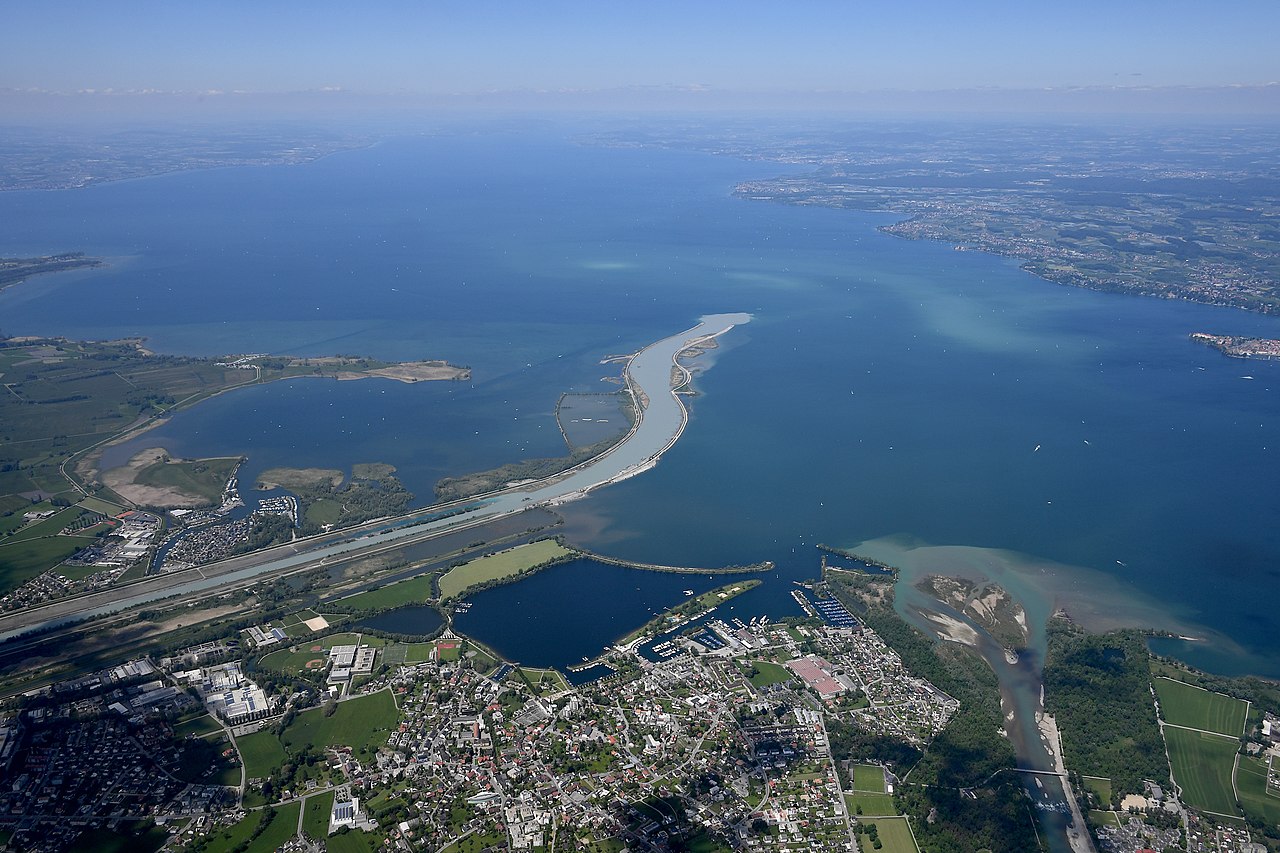
As an effect of human work, it empties into Lake Constance on Austrian territory and not on the border that follows its old natural river bed called Alter Rhein (lit. 'Old Rhine').
The mouth of the Rhine into Lake Constance forms an inland delta. The delta is delimited in the west by the Alter Rhein and in the east by the modern canalized section of the Alpine Rhine (Fußacher Durchstich). Most of the delta is a nature reserve and bird sanctuary. It includes the Austrian towns of Gaißau, Höchst and Fußach. The natural Rhine originally branched into at least two arms and formed small islands by precipitating sediments. In the local Alemannic dialect, the singular is pronounced "Isel" and this is also the local pronunciation of Esel ("Donkey"). Many local fields have an official name containing this element.
A regulation of the Rhine was called for, with an upper canal near Diepoldsau and a lower canal at Fußach, in order to counteract the constant flooding and strong sedimentation in the western Rhine Delta. The Dornbirner Ach had to be diverted, too, and it now flows parallel to the canalized Rhine into the lake. Its water has a darker color than the Rhine; the latter's lighter suspended load comes from higher up the mountains. It is expected that the continuous input of sediment into the lake will silt up the lake. This has already happened to the former Lake Tuggenersee.
The cut-off Old Rhine at first formed a swamp landscape. Later an artificial ditch of about two km was dug. It was made navigable to the Swiss town of Rheineck.
Lake Constance
Lake Constance (Bodensee) consists of three bodies of water: the Obersee (lit. 'upper lake'), the Untersee (lit. 'lower lake'), and a connecting stretch of the Rhine, called the Seerhein (lit. 'Rhine of the lake(s)'). The lake is situated in Germany, Switzerland and Austria near the Alps. Specifically, its shorelines lie in the German states of Bavaria and Baden-Württemberg, the Austrian state of Vorarlberg, and the Swiss cantons of Schaffhausen, St. Gallen and Thurgau. The Rhine flows into it from the south following the Swiss-Austrian border. It is located at approximately 47°39′N 9°19′E.
Obersee
The flow of cold, grey mountain water continues for some distance into the lake. The cold water flows near the surface and at first does not mix with the warmer, green waters of Upper Lake. But then, at the so-called Rheinbrech, the Rhine water abruptly falls into the depths because of the greater density of cold water. The flow reappears on the surface at the northern (German) shore of the lake, off the island of Lindau. The water then follows the northern shore until Hagnau am Bodensee. A small fraction of the flow is diverted off the island of Mainau into Lake Überlingen. Most of the water flows via the Constance Hopper into the Rheinrinne (lit. 'Rhine Gutter') and Seerhein. Depending on the water level, this flow of the Rhine water is clearly visible along the entire length of the lake.
The Rhine carries very large amounts of debris into the lake – over three million cubic meters (110,000,000 cu ft) annually. In the mouth region, it is therefore necessary to permanently remove gravel by dredging. The large sediment loads are partly due to the extensive land improvements upstream.
Three countries border the Obersee, namely Switzerland in the south, Austria in the southeast and the German states of Bavaria in the northeast and Baden-Württemberg in the north and northwest.
Seerhein
The Seerhein is only 4 kilometers (2.5 mi) long. It connects the Obersee with the 30 cm (12 in) lower Untersee. Distance markers along the Rhine measure the distance from the bridge in the old city center of Konstanz.
For most of its length, the Seerhein forms the border between Germany and Switzerland. The exception is the old city center of Konstanz, on the Swiss side of the river.
The Seerhein emerged in the last thousands of years, when erosion caused the lake level to be lowered by about 10 metres (33 ft). Previously, the two lakes formed a single lake, as the name still suggests.
Untersee
Like in the Obersee, the flow the Rhine can be traced in the Untersee. Here, too, the river water is hardly mixed with the lake water. The northern parts of the Untersee (Lake Zell and Gnadensee) remain virtually unaffected by the flow. The river traverses the southern, which, in isolation, is sometimes called Rhinesee (lit. 'Lake Rhine'). The Schweizerische Schifffahrtsgesellschaft Untersee und Rhein (URh) offers regular boat trips on Untersee.
Besides the Seerhein, the Radolfzeller Aach is the main tributary of Untersee. It adds large amounts of water from the Danube system to the Untersee via the Danube Sinkhole.
Reichenau Island was formed at the same time as the Seerhein, when the water level fell to its current level.
Lake Untersee is part of the border between Switzerland and Germany, with Germany on the north bank and Switzerland on the south, except both sides are Swiss in Stein am Rhein, where the High Rhine flows out of the lake.
High Rhine
The High Rhine (Hochrhein) begins in Stein am Rhein at the western end of the Untersee. Now flowing generally westwards, it passes over the Rhine Falls (Rheinfall) below Schaffhausen before being joined – near Koblenz in the canton of Aargau – by its major tributary, the Aare. The Aare more than doubles the Rhine's water discharge, to an average of slightly more than 1,000 m3/s (35,000 cu ft/s), and provides more than a fifth of the discharge at the Dutch border. The Aare also contains the waters from the 4,274 m (14,022 ft) summit of Finsteraarhorn, the highest point of the Rhine basin.
Between Eglisau and Basel, the vast majority of its length, the High Rhine forms the border between Germany and Switzerland. Only for brief distances at its extremities does the river run entirely within Switzerland; at the eastern end it separates the bulk of the canton of Schaffhausen and the German exclave of Büsingen am Hochrhein on the northern bank from cantons of Zürich and Thurgau, while at the western end it bisects the canton of Basel-Stadt. Here, at the Rhine knee, the river turns north and leaves Switzerland altogether.
The High Rhine is characterized by numerous dams. On the few remaining natural sections, there are still several rapids. Over its entire course from Lake Constance to the Swiss border at Basel the river descends from 395 to 252 m (1,296 to 827 ft).
There are passenger boat lines on the lower High Rhine and between Schaffhausen and Kreuzlingen.
Upper Rhine
In the center of Basel, the first major city in the course of the stream, is the Rhine knee, a major bend, where the overall direction of the Rhine changes from west to north. Here the High Rhine ends. Legally, the Central Bridge is the boundary between High and Upper Rhine. The river now flows north as Upper Rhine through the Upper Rhine Plain, which is about 300 km long and up to 40 km wide. The most important tributaries in this area are the Ill below of Strasbourg, the Neckar in Mannheim and the Main across from Mainz. In Mainz, the Rhine leaves the Upper Rhine Valley and flows through the Mainz Basin.
The southern half of the Upper Rhine forms the border between France (Alsace) and Germany (Baden-Württemberg). The northern part forms the border between the German states of Rhineland-Palatinate in the west on the one hand, and Baden-Württemberg and Hesse on the other hand, in the east and north. A curiosity of this border line is that the parts of the city of Mainz on the right bank of the Rhine were given to Hesse by the occupying forces in 1945.