
New Westminster (colloquially known as New West, hən̓q̓əmin̓əm̓: sӽəyəməɬ) is a city in the Lower Mainland region of British Columbia, Canada, and a member municipality of the Metro Vancouver Regional District.
It was founded in 1858 by Richard Clement Moody as the capital of the Colony of British Columbia, and served as such until the mainland and Vancouver Island colonies were merged to form the new Colony of British Columbia in 1866. It was the British Columbia mainland's largest city from its foundation until the first decade of the 20th century, when it was surpassed in population by Vancouver.
It is located on the banks of the Fraser River as it turns southwest towards its estuary, on the southwest side of the Burrard Peninsula and roughly at the centre of the Greater Vancouver region.
History
The area now known as New Westminster was originally inhabited by Kwantlen First Nation. The discovery of gold in BC and the arrival of gold seekers from the south prompted fear amongst the settlers that Americans may invade to take over this land.
Richard Clement Moody, a colonel, arrived in British Columbia in December 1858, at the head of the Royal Engineers, Columbia Detachment, having been hand picked to 'found a second England on the shores of the Pacific' and to transform the new colony into the British Empire's 'bulwark in the farthest west'. Moody "wanted to build a city of beauty in the wilderness" and planned his city as an iconic visual metaphor for British dominance, "styled and located with the objective of reinforcing the authority of the Crown and of the robe". Subsequent to the enactment of the Pre-emption Act of 1860, Moody settled the Lower Mainland and selected the site and founded the new capital, New Westminster. Moody and the Royal Engineers were trained in settlement and selected the site because of its defensibility: it was farther from the American border than the site of the colony's proclamation, Fort Langley, possessed "great facilities for communication by water, as well as by future great trunk railways into the interior", and possessed an excellent port. Moody was also struck by the majestic beauty of the site, writing in his letter to Blackwood:
The entrance to the Fraser is very striking—Extending miles to the right & left are low marsh lands (apparently of very rich qualities) & yet fr [sic] the Background of Superb Mountains—Swiss in outline, dark in woods, grandly towering into the clouds there is a sublimity that deeply impresses you. Everything is large and magnificent, worthy of the entrance to the Queen of England's dominions on the Pacific mainland. [...] My imagination converted the silent marshes into Cuyp-like pictures of horses and cattle lazily fattening in rich meadows in a glowing sunset. [...] The water of the deep clear Frazer was of a glassy stillness, not a ripple before us, except when a fish rose to the surface or broods of wild ducks fluttered away.

It was suggested by Moody and the Royal Engineers, Columbia Detachment that the site be proclaimed "Queensborough". Governor James Douglas proclaimed the new capital with this name on February 14, 1859. The name "Queensborough", however, did not appeal to London and it was Queen Victoria who named the city after Westminster, that part of the British capital of London where the Parliament Buildings were, and are to this day, situated. From this naming by the Queen, the City gained its official nickname, "the Royal City". A year later New Westminster became the first City in British Columbia to be incorporated and have an elected municipal government. It became a major outfitting point for prospectors coming to the Fraser Gold Rush, as all travel to the goldfield ports of Yale and Port Douglas was by steamboat or canoe up the Fraser River.
However, Colonial Office secretary Edward Bulwer-Lytton "forgot the practicalities of paying for clearing and developing the site and the town" and the efforts of Moody's engineers were continuously hampered by insufficient funds, which, together with the continuous opposition of Douglas, "made it impossible for [Moody's] design to be fulfilled".
Governor Douglas spent little time in New Westminster and had little affection for the city; and the feelings were amply repaid by the citizens of New Westminster, who avidly supported Moody's city-building efforts and castigated the governor, who preferred to remain for the most part isolated in distant Victoria. In contrast to Victoria, where settlers from England had established a strong British presence, New Westminster's early citizens were largely Canadians and Maritimers, who brought a more business-oriented approach to commerce and dismissed the pretensions of the older community. Despite being granted a municipal council, the mainlanders in New Westminster also pressed for a legislative assembly to be created for British Columbia, and were infuriated when Governor Douglas granted free port status to Victoria, which stifled the economic growth of the Fraser River city. Moreover, to pay for the expense of building roads into the Interior of the colony, Douglas imposed duties on imports into New Westminster.
In 1866, the Colony of British Columbia and the Colony of Vancouver Island were united as "British Columbia". However, the capital of the Colony of Vancouver Island, Victoria, was made the capital of the newly amalgamated Colony of British Columbia following a vote in the House of Assembly. On the day of the vote, one member of the assembly, William Cox (one of the colony's Gold Commissioners and a Victoria supporter), shuffled the pages of the speech that William Franklyn from Nanaimo (a New Westminster supporter) intended to give, so that Franklyn lost his place and read the first paragraph three times. Cox then popped the lenses of Franklyn's glasses from their frames so that the Nanaimo representative could see nothing at all of his speech. After a recess to settle the resulting uproar and allow the member from Nanaimo a chance to sort out his speaking notes and his spectacles, the Speaker John Sebastian Helmcken (from Victoria) refused to allow Franklyn a "second" chance to speak. The subsequent vote was 13 to 8 against New Westminster.
With the entry of British Columbia into the Dominion of Canada in 1871, as the sixth province, New Westminster's economic prospects improved, but the Royal City would lose out again, this time to the new railway terminus town of Vancouver, when the Canadian Pacific Railway was extended to the shores of Burrard Inlet, even though a spur of the railway did reach New Westminster in 1886.
In 1898, a fire destroyed downtown New Westminster, and in 1916 the federal government shut down the "common" reserves set aside for Coastal First Nations people who visited New Westminster during the fishing season. In 1916 the remaining land on Poplar Island was turned over to the BC government.

From 1927 to 1969, the British Columbia Shore Station Oceanographic Program was collecting coastal water temperature and salinity measurements from New Westminster every day for the Department of Fisheries and Oceans.
In 1991, the New Westminster Armoury was recognized as a Federal Heritage building on the Register of the Government of Canada Heritage Buildings. Along with the rest of the Greater Vancouver region, in 2020 New Westminster experienced the worst air quality in the world due to the combined effects of the 2020 Western American wildfires and a fire at the old Pier at the quay.
In 2022, efforts were made within the city to phase-out the "Royal City" moniker and undergo a rebrand of the city's logo and mottos. The citys logo was rebranded on June 9, 2025.

Geography
New Westminster is located on the Burrard Peninsula, mainly on the north bank of the Fraser River. It is 19 kilometres (12 mi) southeast of the City of Vancouver proper, adjacent to Burnaby and Coquitlam and across the Fraser River from Surrey and Delta. A portion of New Westminster called Queensborough is located on the eastern tip of Lulu Island, adjacent to Richmond. The total land area is 15.62 square kilometres (6.03 mi2).
Historical urban geography
New Westminster has changed markedly over time and by the results of its incorporation into the wider urbanization of the Lower Mainland. (See also: Architecture of Greater Vancouver.)
BC Penitentiary
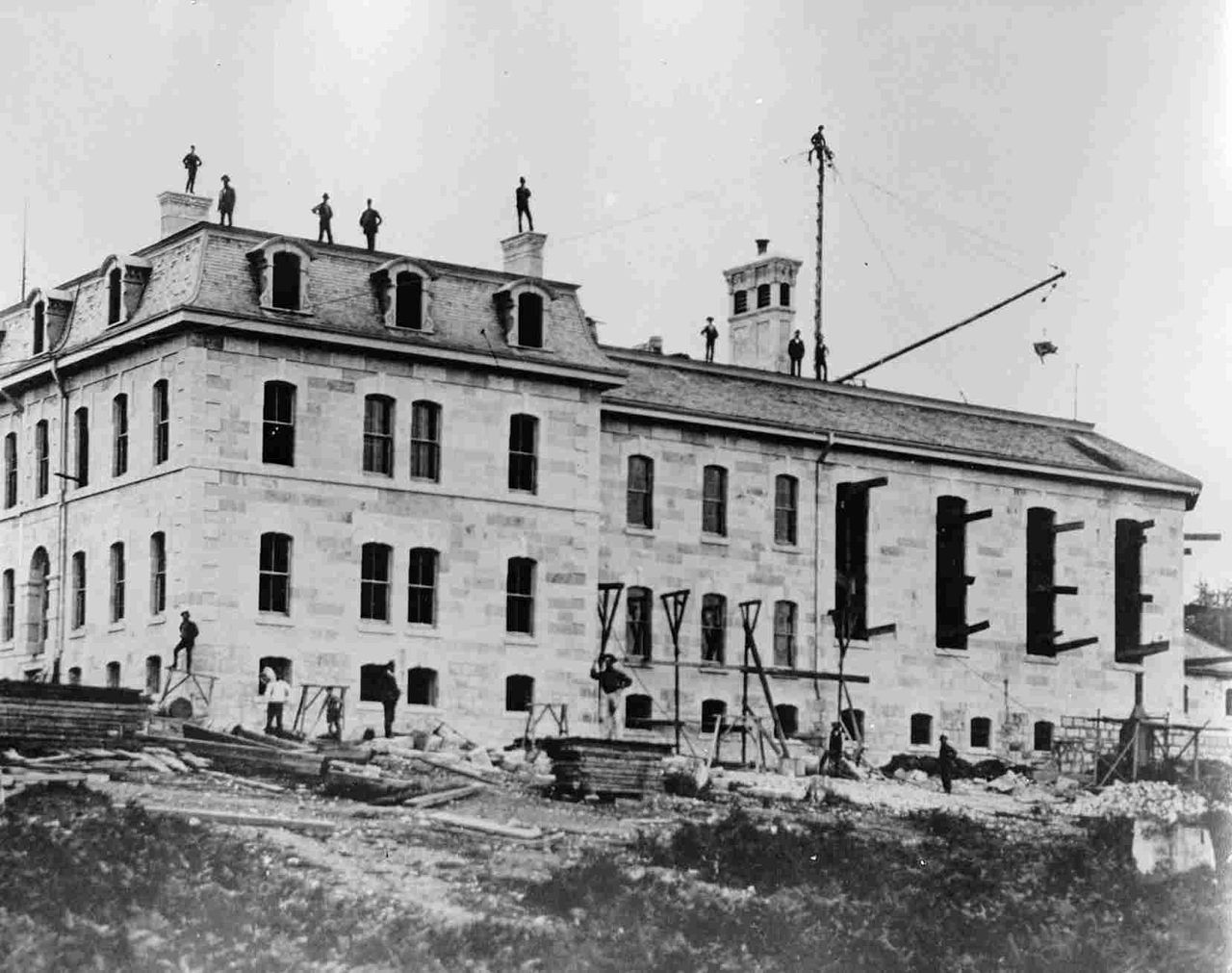
In 1878, the Government of Canada opened the British Columbia Penitentiary, the first federal penitentiary west of Manitoba. "BC Pen", or simply "the Pen", as it was known (and also in old days as the "skookum house" in the English-Chinook Jargon patois common in early BC), was located between the Sapperton neighbourhood and what is now Queen's Park. It housed maximum-security prisoners for the next 102 years, closing in 1980. The original centre block of the Pen still stands and has been converted into offices. The Gatehouse, steps leading up to it and old Coal House still stand. The rest of the Pen's grounds have been filled with newly built townhouses and condominiums and parkland. Below the main complex on the waterfront the prison's old armoury still stands as part of a new waterfront park; this was also the location of the prison's wharf which was much-used when steamboat was the main means of transportation within the Lower Mainland and for some years after.

Woodlands
The mental hospital for children, was located to the west of the BC Pen and was adjacent to the offramps of the Pattullo Bridge. After it was closed, the derelict main building was, except for the tower entrance, destroyed by fire on July 9, 2008. In October 2011, all remaining old structures were levelled and cleared, to the joy of some former residents who had bad memories of their childhood experiences.
Chinatown
New Westminster's Chinatown was one of the earliest established in the mainland colony and initially the second-largest after Victoria's. Prior to the rise of Vancouver's Chinatown it was the largest on the mainland following Barkerville's wane as a centre of population.
It was located along Front Street. A second Chinatown opened in an area known as "The Swamp" at the southwestern edge of downtown, bounded roughly by Royal Avenue, Columbia Street, and 8th and 12th Streets. The "Swamp" name is because area was then boggy ground of low value for the stone and brick buildings of the main part of downtown up Columbia Street to the northeast; and also close to the river and the railway.
Chinatown was destroyed in the Great Fire of 1898 and only partly rebuilt afterwards, with a church and cultural and community events hall the first to be started.
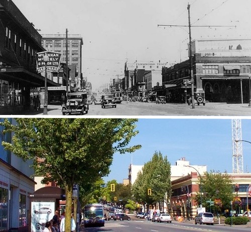
Columbia Street
Until the 1964 completion of the Highway 1 freeway, which bypassed New Westminster to its north, Columbia Street, the downtown core of New Westminster close to the city's waterfront, was the main commercial retail and service centre for the Fraser Valley and nearby areas of Burnaby and Coquitlam. Known as "the golden mile", it hosted major department stores such as Eaton's, Kresge's and Woolworths as well as long-established New Westminster retailers. This was a time when road travel to Vancouver remained distant for Valley communities, and daily interurban rail service to and from Chilliwack was still in place (the service ended in 1950). The quality of shops was such that even Vancouverites would make the trip by interurban rail or, later on, via Kingsway (originally called the Westminster Highway or Westminster Road), to shop on Columbia Street. In addition to the retailers, Columbia Street was home to major movie houses, the Columbia and the Paramount, rivalling in size and quality to those on Vancouver's Theatre Row. The freeway and the building of suburban malls with free parking is generally conceded to have "killed" Columbia Street, which fell into a slump despite the building of a large parkade above nearby Front Street in the 50s and 60s. Department stores (other than the Army and Navy) left downtown as the Uptown area continued to develop to become New Westminster's main retail and services centre. In October 2006, Columbia Street underwent reconstruction to change to one lane in both directions, with a bike lane and reverse angle parking. This was done to encourage more foot and bicycle traffic. Major high-rise or renovation projects are completed or nearing completion. By May 2012, these include the Plaza 88 development which includes three condominium towers, the complete renovation of the Columbia which is now a cabaret style theatre for concerts, weddings and fundraisers, and the home of Lafflines Comedy Club. The new $25 million Westminster Pier Park officially opened on June 16, 2012, and a new civic centre and office tower named The Anvil Centre on Columbia Street at Begbie Street completed in September 2014. The Salient Group built a tower on top of the Trapp + Holbrook buildings (while restoring the facade) and another condominium called Northbank was built at the east entrance of Columbia Street. Close to the Trapp building, a major fire razed the E.L. Lewis Building and the Hamley Block on October 13, 2013, displacing 30 businesses and destroying a chunk of Columbia Street's historical character. One of the most well-known of these businesses was Copp's Shoes, which had not changed between its 1925 opening and its closure in early 2013.
Connaught Heights
The westernmost neighbourhood in the city, Connaught Heights, began life as District Lot 172 after the Royal Engineers surveyed the land in the 1860s. In 1892, when the official civic boundaries for New Westminster were set, they only included its original city and suburban lots, thus leaving District Lot 172 disincorporated. The City of Burnaby also chose not to incorporate District Lot 172 when its official civic boundaries were set, resulting in the area being outside any municipal jurisdiction.
In 1911, the original landowner subdivided the land into residential lots that followed the grid established by neighbouring New Westminster; the first residential home had only been built a year prior. In 1912, the BC Electric Railway took advantage of this by building the "Connaught Hill" station at Tenth Avenue for the new interurban electric tramway, which connected New Westminster with Vancouver. The station was named for Prince Arthur, Duke of Connaught and Strathearn. This station became the namesake for the neighbourhood, while the modern SkyTrain tracks follow the path of this historic tramway.
Initially, the provincial government neglected the district, but as the density of residents increased so did the quality of amenities and civic services. In 1939, when there were approximately 200 homes, funding was secured to improve the water and electric services under the Municipality Improvements Assistance Act 1938. Before the improvements, District Lot 172 was designated as Connaught Heights Waterworks District under the Water Act. Following these improvements, land was set aside for a school and parksite. By the 1950s, the notion of incorporating Connaught Heights Waterworks District into New Westminster became more commonplace. In 1960, the construction of the Queensborough Bridge resulted in the demolition of property in Connaught Heights Waterworks District, showing further interaction between the city and district. The first of two referendums to vote on incorporating Connaught Heights Waterworks District into the City of New Westminster was held in 1961, which failed to achieve enough positive votes to proceed with incorporation. Construction of Connaught Heights Elementary School was completed in 1963, and the school was opened and joined the New Westminster School District the following year. A second referendum was held in 1964, which garnered enough positive votes to make Connaught Heights Waterworks District part of New Westminster. By 1965, the amalgamation was officially complete, with Connaught Heights becoming the newest neighbourhood in New Westminster.
Front Street
Originally a dockside street and market, and also the location of the original Chinatown, Front Street was converted into a truck-route bypass and elevated parkade during the 1960s in an effort to provide increased parking for adjacent Columbia Street. In recent decades it has been the focus of the city's thriving antiques and second-hand trade, which is also concentrated on 12 Street. It has also been used as a location in feature films such as Rumble in the Bronx (substituting for the Bronx), I, Robot (as a futuristic Chicago), Shooter (doubling for Philadelphia, with the Fraser River being the Delaware River), and New Moon. In early 2016, a partial demolition of the parkade commenced as part of the City's continued efforts to revitalize and improve their waterfront area.
Government House
The original colonial Government House was located approximately where Royal City Manor is now. It was originally occupied by Richard Clement Moody, who commanded the Columbia Detachment of Royal Engineers who established the city. Rarely used by Governor Douglas, its first full-time viceregal resident was Governor Frederick Seymour.
New Westminster Canadian Pacific Railway Station
A former Canadian Pacific Railway station is adjacent to the New Westminster Skytrain station. It is a two-storey asymmetrical red brick building with steeply pitched bellcast roofs. The building, which was built in 1899, is a classic example of CPR's signature Château-styled railway stations. In 1911, two wings were added to the station, and in 1973, the ageing train station was converted into a branch of The Keg restaurant chain. In 2013, however, the restaurant closed its doors to the public due to structural issues surrounding the then-114-year-old structure. As of 2023, the train station is occupied by Kelly O'Bryan's, a BC Irish restaurant and pub chain.
Queensborough
Queensborough was the name originally chosen for the colonial capital by Royal Engineer commander Colonel Richard Clement Moody. When Queen Victoria designated New Westminster instead as her new capital's name, the name Queensborough became applied to New Westminster's portion of Lulu Island, across the north arm of the Fraser from the southern end of the city. Queensborough is today a growing housing area with its own distinct identity. Some new condominium complexes have been built adjacent to the Westminster Quay development. In Chinook Jargon, "Koonspa", an adaptation of the name Queensborough, is the usual name for New Westminster as a whole.
Sapperton
Sapperton was originally a "suburb" of New Westminster, named for the Columbia Detachment of Royal Engineers ("Sappers"), whose camp was on the hill now occupied by the Fraserview neighbourhood. It is the location of the historic Fraser Cemetery, which rivals Victoria's Ross Bay Cemetery for the number of historically significant graves and monuments. Sapperton is the home of the first commercial brewery to operate in British Columbia known as the "City Brewery". Over the years the brewery changed hands and was operated by Labatts until it closed in 2005. In its place is a recent condo development known as the "Brewery District", although there is no brewery on the premises. New Westminster does have two breweries currently. One is named Steel & Oak which opened its doors in 2014 and is situated on the other end of the Westminster Quay. The other brewery in New Westminster is named Another Beer Co and it is located in Sapperton, close to where the Labatts Brewery was in the Brewery District, since 2019. Also located in Sapperton are the Royal Columbian Hospital, Sapperton Station, Braid Station, and the TransLink (British Columbia) headquarters.
Uptown "6th and 6th"
Development of an uptown commercial area around 6th Street and 6th Avenue started in 1954, with the opening of Woodward's department store. Added momentum came with the relocation of the public library from downtown to uptown in 1958. In 1992 Woodward's was expanded and modernized into a shopping centre and took the name Woodwards Place. With the bankruptcy of Woodward's in 1993, the name of the centre was changed to Royal City Centre Mall. Moody Park is an important recreational area in the uptown area.
West End
Opposite Sapperton's north end, New Westminster's West End was once fairly separate from the city proper, and has a neighbourhood commercial node along 12th Street and 20th Street approximately between London Street and Eighth Ave. The 12th Street area features antique and one-of-a-kind stores.
Westminster Quay
Westminster Quay was a mid-1980s development to revitalize New Westminster and accompanied the development of the SkyTrain line to Vancouver. In addition to a large public market and a 2.5-diamond-rated hotel, The Inn at the Quay, a large condominium tower and townhouse complex was built, accessed from the older Columbia Street area of downtown by an overpass. The impetus provided by this project has spilled over onto the inland side of the rail tracks, with new tower developments focusing on the area southwest of 8th Street (the area known formerly as "the Swamp" and Chinatown). As of July 2007, the Quay's commercial component had noticeably decreased, with many vacancies, compared to the much more active Lonsdale Quay Market in North Vancouver. Responding to the decrease of business, the ownership group closed the Westminster Quay Market for renovations. The market re-opened as The River Market in September 2010 with Donald's Market as the main anchor. The Westminster Quay is also known to house a 9.75-metre-tall (32.0 ft) tin soldier which was given the title of the world's largest by the Guinness Book of World Records back in 2002.
Demographics
In the 2021 Canadian census conducted by Statistics Canada, New Westminster had a population of 78,916 living in 36,099 of its 37,737 total private dwellings, a change of 11.2% from its 2016 population of 70,996. With a land area of 15.62 km2 (6.03 sq mi), it had a population density of 5,052.2/km2 (13,085.2/sq mi) in 2021. New Westminster had the second highest population density of any Canadian city, trailing only Vancouver.
Ethnicity
A legacy of early 20th century settlement, the Queensborough neighbourhood has a large South Asian population, primarily of Punjabi Sikh descent.
Languages
The 2016 census found that English was spoken as mother tongue by 50.47% of the population. The next most common mother tongue language was Tagalog, spoken by 4.5% of the population, followed by Mandarin at 4.4%, and Punjabi at 3.5%.
Religion
According to the 2021 census, religious groups in New Westminster included:
Irreligion (36,595 persons or 46.9%)
Christianity (30,345 persons or 38.9%)