Mount Bird (77°17′S 166°43′E) is a 1,765 metres (5,791 ft) high shield volcano standing about 7 nautical miles (13 km; 8.1 mi) south of Cape Bird, the northern extremity of Ross Island. It was mapped by the British National Antarctic Expedition, 1901–04, under Robert Falcon Scott, and apparently named by them after Cape Bird.
Geography
Mount Bird was originally a separate island, which through volcanic activity has become a rounded peninsula on the northwestern tip of Ross Island. At its southernmost point, where it is connected with the rest of the island by a 10-kilometre (6.2 mi) wide isthmus, a 500-metre (1,600 ft) high pass, Bird Pass, separates the bulk of Mount Bird from the northern slopes of Mount Erebus. The peninsula is flanked to the west and east by two large and frequently ice-bound bays, Wohlschlag Bay in the west and Lewis Bay in the east.
Geology
Mount Bird is a basaltic shield volcano that was active from 4.6 to 3.8 million years ago. On the flanks of the volcano there are poorly exposed basalt scoria cones, and phonolite domes and flows. The coastal cliffs display the shield's thick stack of basalt lava flows.

Glaciers and streams
Several glaciers or meltwater streams flow from the mountain to the sea.
Fitzgerald Stream
77°16′S 166°21′E.
A stream between Fitzgerald Hill and Inclusion Hill on the lower ice-free west slopes of Mount Bird, flowing to McMurdo Sound across McDonald Beach.

Explored by the NZGSAE, 1958-59, and named by the NZ-APC for E.B. Fitzgerald, deputy leader of the expedition.
Shell Glacier
77°16′S 166°25′E.
A western lobe of the Mount Bird icecap.

It descends steeply in the valley north of Trachyte Hill and Harrison Bluff in the center of the ice-free area on the lower western slopes of Mount Bird.
Mapped and so named by the New Zealand Geological Survey Antarctic Expedition (NZGSAE), 1958–59, because of the marine shell content of the moraines.
Harrison Stream
77°17′S 166°24′E.
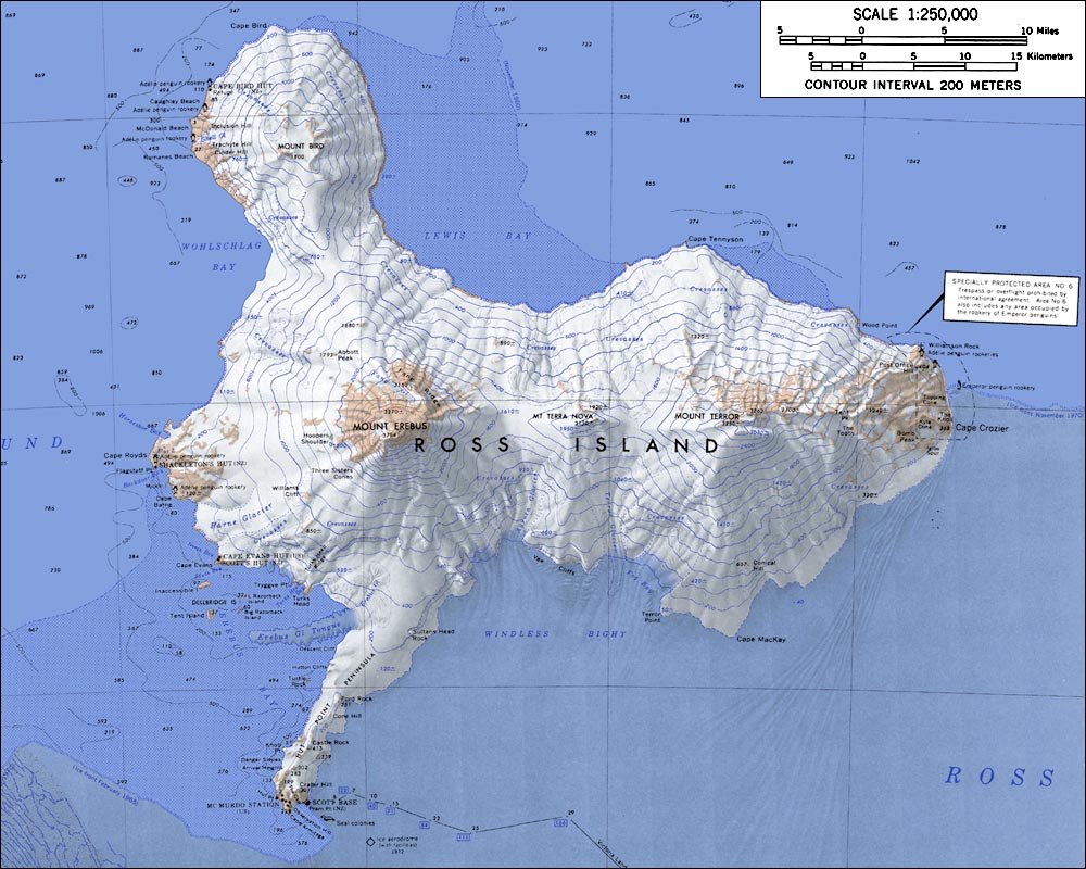
A small stream flowing west between Trachyte and Cinder Hills to the north end of Romanes Beach.
Mapped by the NZGSAE, 1958-59.
Named by the New Zealand Antarctic Place-Names Committee (NZ-APC) for J. Harrison, mountaineer-assistant with the expedition.

Wilson Stream
77°17′S 166°26′E.
A meltwater stream which flows from the ice-free lower west slopes of Mount Bird, to the south of Alexander Hill, and over steep sea cliffs into Wohlschlag Bay.
Mapped by the NZGSAE, 1958-59, and named by the NZ-APC for J. Wilson, mountaineer assistant with the expedition.

Quaternary Icefall
77°18′S 166°30′E.
A western lobe of the Mount Bird icecap, descending steeply into Wohlschlag Bay 1 nautical mile (1.9 km; 1.2 mi) south of Cinder Hill.
Mapped and so named by the NZGSAE, 1958-59, because of the Quaternary glacial period marine shells carried by the glacier and deposited in terminal moraines.
Endeavour Piedmont Glacier
77.406111°S 166.710398°E / -77.406111; 166.710398.
A piedmont glacier, 6 nautical miles (11 km; 6.9 mi) long and 2 nautical miles (3.7 km; 2.3 mi) wide, between the southwest part of Mount Bird and Micou Point.
In association with the names of expedition ships grouped on this island, named after HMNZS Endeavour, tanker/supply ship which for at least 10 seasons, 1962-63 to 1971-72, transported bulk petroleum products and cargo to Scott Base and McMurdo Station on Ross Island.
Northern features
Inland features around the north of Mount Bird include:
Takahe Nunatak
77.21506°S 166.803196°E / -77.21506; 166.803196.
The northern of two similar nunataks that lie 0.3 nautical miles (0.56 km; 0.35 mi) apart and 3.3 nautical miles (6.1 km; 3.8 mi) north-northeast of Mount Bird in northwest Ross Island. It rises to about 1,100 metres (3,600 ft) high and, like Kakapo Nunatak is one of several features near Mount Bird assigned the native name of a New Zealand mountain bird. Named by New Zealand Geographic Board (NZGB), 2000.
Kakapo Nunatak
77.220489°S 166.795824°E / -77.220489; 166.795824.
The southern of two similar nunataks that lie 0.3 nautical miles (0.56 km; 0.35 mi) apart and 3.3 nautical miles (6.1 km; 3.8 mi) north-northeast of Mount Bird in northwest Ross Island. It rises to about 1,200 metres (3,900 ft) high and, like Takahe Nunatak close NE, appears to be part of an ice-covered crater rim. Kakapo Nunatak is one of several features near Mount Bird assigned the native name of a New Zealand mountain bird. Named by New Zealand Geographic Board (NZGB), 2000.
Norman Crag
77.233769°S 166.746487°E / -77.233769; 166.746487.
A rugged nunatak 2.2 nautical miles (4.1 km; 2.5 mi) north of the summit of Mount Bird. The feature has a divided summit area and rises to over 1,400 metres (4,600 ft). Named by New Zealand Geographic Board (NZGB) (2000) after Bob Norman.
Ruru Crests
77.240196°S 166.634762°E / -77.240196; 166.634762.
Two parallel rock ridges 2.2 nautical miles (4.1 km; 2.5 mi) northwest of the summit of Mount Bird. The feature rises to about 1,400 metres (4,600 ft). It is one of several landmarks near Mount Bird assigned the native name of a New Zealand mountain bird. Named by New Zealand Geographic Board (NZGB), 2000.
Nash Peak
77.252198°S 166.739187°E / -77.252198; 166.739187.
A prominent peak 1.4 nautical miles (2.6 km; 1.6 mi) north of the Mount Bird summit in northwest Ross Island.
The feature rises to over 1,600 metres (5,200 ft).
Named by the New Zealand Geographic Board (NZGB) (2000) after Sir Walter Nash, who was deeply involved in promoting New Zealand's role in Antarctica and who signed the Antarctic Treaty for New Zealand as Prime Minister.
Wong Peak
77.251495°S 166.834328°E / -77.251495; 166.834328
A peak 1.6 nautical miles (3.0 km; 1.8 mi) northeast of the summit of Mount Bird in northwest Ross Island.
The feature rises to over 1,600 metres (5,200 ft).
Named by New Zealand Geographic Board (NZGB) (2000) after Frank Wong.
Beeby Peak
77.257089°S 166.907954°E / -77.257089; 166.907954.
A peak 2.4 nautical miles (4.4 km; 2.8 mi) east-northeast of the summit of Mount Bird in northwest Ross Island. The feature rises to about 1,400 metres (4,600 ft).