The Mississippi River is the primary river of the largest drainage basin in the United States. It is the second-longest river in the United States, behind only the Missouri. From its traditional source of Lake Itasca in northern Minnesota, it flows generally south for 2,340 mi (3,766 km) to the Mississippi River Delta in the Gulf of Mexico. With its many tributaries, the Mississippi's watershed drains all or parts of 32 U.S. states and two Canadian provinces between the Rocky and Appalachian mountains. The river either borders or passes through the states of Minnesota, Wisconsin, Iowa, Illinois, Missouri, Kentucky, Tennessee, Arkansas, Mississippi, and Louisiana. The main stem is entirely within the United States; the total drainage basin is 1,151,000 mi2 (2,980,000 km2), of which only about one percent is in Canada. The Mississippi ranks as the world's tenth-largest river by discharge flow, and the largest in North America.
Native Americans have lived along the Mississippi River and its tributaries for thousands of years. Many were hunter-gatherers, but some, such as the Mound Builders, formed prolific agricultural and urban civilizations, and some practiced aquaculture. The arrival of Europeans in the 16th century changed the native way of life as first explorers, then settlers, ventured into the basin in increasing numbers. The river served sometimes as a barrier, forming borders for New Spain, New France, and the early United States, and throughout as a vital transportation artery and communications link. In the 19th century, during the height of the ideology of manifest destiny, the Mississippi and several tributaries, most notably its largest, the Ohio and Missouri, formed pathways for the western expansion of the United States. The river also became the subject of American literature, particularly in the writings of Mark Twain.
Formed from thick layers of the river's silt deposits, the Mississippi embayment, and American Bottom are some of the most fertile regions of the United States; steamboats were widely used in the 19th and early 20th centuries to ship agricultural and industrial goods. During the American Civil War, the Mississippi's final capture by Union forces marked a turning point to victory for the Union. Because of the substantial growth of cities and the larger ships and barges that replaced steamboats, the first decades of the 20th century saw the construction of massive engineering works such as levees, locks and dams, often built in combination. A major focus of this work has been to prevent the lower Mississippi from shifting into the channel of the Atchafalaya River and bypassing New Orleans.

Since the 20th century, the Mississippi River has also experienced major pollution and environmental problems, most notably elevated nutrient and chemical levels from agricultural runoff, the primary contributor to the Gulf of Mexico dead zone.
Name and significance
The word Mississippi itself comes from Misi zipi, the French rendering of the Anishinaabe (Ojibwe or Algonquian) name for the river, Misi-ziibi (Great River).
In the 18th century, the river was set by the Treaty of Paris as, for the most part, the western border of the new United States. With the Louisiana Purchase and the country's westward expansion, it became a convenient boundary line between the western and eastern halves of the country. This is reflected in the Gateway Arch in St. Louis, which was designed to symbolize the opening of the West, and the focus on the "Trans-Mississippi" region in the Trans-Mississippi Exposition.
Regional landmarks are often classified in relation to the river, such as "the highest peak east of the Mississippi" or "the oldest city west of the Mississippi". The FCC also uses it as the dividing line for broadcast call-signs, which begin with W to the east and K to the west, overlapping in media markets along the river.
Due to its size and importance, it has been nicknamed The Mighty Mississippi River or simply The Mighty Mississippi.
Divisions
The Mississippi River can be divided into three sections: the Upper Mississippi, the river from its headwaters to the confluence with the Missouri River; the Middle Mississippi, which is downriver from the Missouri to the Ohio River; and the Lower Mississippi, which flows from the Ohio to the Gulf of Mexico.

Upper Mississippi
The Upper Mississippi runs from its headwaters to its confluence with the Missouri River at St. Louis, Missouri. It is divided into two sections:
The headwaters, 493 miles (793 km) from the source to Saint Anthony Falls in Minneapolis, Minnesota; and
A navigable channel, formed by a series of human-made lakes between Minneapolis and St. Louis, Missouri, some 664 miles (1,069 km).

The source of the Upper Mississippi branch is traditionally accepted as Lake Itasca, 1,475 feet (450 m) above sea level in Itasca State Park in Clearwater County, Minnesota. The name Itasca was chosen to designate the "true head" of the Mississippi River as a combination of the last four letters of the Latin word for truth (veritas) and the first two letters of the Latin word for head (caput). However, the lake is in turn fed by a number of smaller streams.
From its origin at Lake Itasca to St. Louis, Missouri, the waterway's flow is moderated by 43 dams. Fourteen of these dams are located above Minneapolis in the headwaters region and serve multiple purposes, including power generation and recreation. The remaining 29 dams, beginning in downtown Minneapolis, all contain locks and were constructed to improve commercial navigation of the upper river. Taken as a whole, these 43 dams significantly shape the geography and influence the ecology of the upper river. Beginning just below Saint Paul, Minnesota, and continuing throughout the upper and lower river, the Mississippi is further controlled by thousands of wing dikes that moderate the river's flow in order to maintain an open navigation channel and prevent the river from eroding its banks.
The head of navigation on the Mississippi is the St. Anthony Falls Lock. Before the Coon Rapids Dam in Coon Rapids, Minnesota, was built in 1913, steamboats could occasionally go upstream as far as Saint Cloud, Minnesota, depending on river conditions.

The uppermost lock and dam on the Upper Mississippi River is the Upper St. Anthony Falls Lock and Dam in Minneapolis. Above the dam, the river's elevation is 799 feet (244 m). Below the dam, the river's elevation is 750 feet (230 m). This 49-foot (15 m) drop is the largest of all the Mississippi River locks and dams. The origin of the dramatic drop is a waterfall preserved adjacent to the lock under an apron of concrete. Saint Anthony Falls is the only true waterfall on the entire Mississippi River. The water elevation continues to drop steeply as it passes through the gorge carved by the waterfall.
After the completion of the St. Anthony Falls Lock and Dam in 1963, the river's head of navigation moved upstream, to the Coon Rapids Dam. However, the Locks were closed in 2015 to control the spread of invasive Asian carp, making Minneapolis once again the site of the head of navigation of the river.
The Upper Mississippi has a number of natural and artificial lakes, with its widest point being Lake Winnibigoshish, near Grand Rapids, Minnesota, over 11 miles (18 km) across. Lake Onalaska, created by Lock and Dam No. 7, near La Crosse, Wisconsin, is more than 4 miles (6.4 km) wide. Lake Pepin, a natural lake formed behind the delta of the Chippewa River of Wisconsin as it enters the Upper Mississippi, is more than 2 miles (3.2 km) wide.

By the time the Upper Mississippi reaches Saint Paul, Minnesota, below Lock and Dam No. 1, it has dropped more than half its original elevation and is 687 feet (209 m) above sea level. From St. Paul to St. Louis, Missouri, the river elevation falls much more slowly and is controlled and managed as a series of pools created by 26 locks and dams.
The Upper Mississippi River is joined by the Minnesota River at Fort Snelling in the Twin Cities; the St. Croix River near Prescott, Wisconsin; the Cannon River near Red Wing, Minnesota; the Zumbro River at Wabasha, Minnesota; the Black, La Crosse, and Root rivers in La Crosse, Wisconsin; the Wisconsin River at Prairie du Chien, Wisconsin; the Rock River at the Quad Cities; the Iowa River near Wapello, Iowa; the Skunk River south of Burlington, Iowa; and the Des Moines River at Keokuk, Iowa. Other major tributaries of the Upper Mississippi include the Crow River in Minnesota, the Chippewa River in Wisconsin, the Maquoketa River and the Wapsipinicon River in Iowa, and the Illinois River in Illinois.
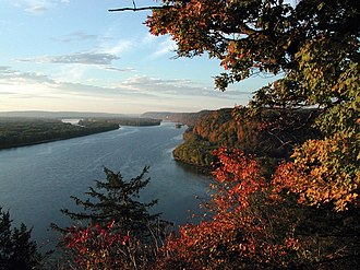
The Upper Mississippi is largely a multi-thread stream with many bars and islands. From its confluence with the St. Croix River downstream to Dubuque, Iowa, the river is entrenched, with high bedrock bluffs lying on either side. The height of these bluffs decreases to the south of Dubuque, though they are still significant through Savanna, Illinois. This topography contrasts strongly with the Lower Mississippi, which is a meandering river in a broad, flat area, only rarely flowing alongside a bluff (as at Vicksburg, Mississippi).
Middle Mississippi
The Mississippi River is known as the Middle Mississippi from the Upper Mississippi River's confluence with the Missouri River at St. Louis, Missouri, for 190 miles (310 km) to its confluence with the Ohio River at Cairo, Illinois.
The Middle Mississippi is relatively free-flowing. From St. Louis to the Ohio River confluence, the Middle Mississippi falls 220 feet (67 m) over 180 miles (290 km) for an average rate of 1.2 feet per mile (23 cm/km). At its confluence with the Ohio River, the Middle Mississippi is 315 feet (96 m) above sea level. Apart from the Missouri and Meramec rivers of Missouri and the Kaskaskia River of Illinois, no major tributaries enter the Middle Mississippi River.
Lower Mississippi
The Mississippi River is called the Lower Mississippi River from its confluence with the Ohio River to its mouth at the Gulf of Mexico, a distance of about 1,000 miles (1,600 km). At the confluence of the Ohio and the Middle Mississippi, the long-term mean discharge of the Ohio at Cairo, Illinois is 281,500 cubic feet per second (7,970 cubic meters per second), while the long-term mean discharge of the Mississippi at Thebes, Illinois (just upriver from Cairo) is 208,200 cu ft/s (5,900 m3/s). Thus, by volume, the main branch of the Mississippi River system at Cairo can be considered to be the Ohio River (and the Allegheny River further upstream), rather than the Middle Mississippi.
In addition to the Ohio River, the major tributaries of the Lower Mississippi River are the White River, flowing in at the White River National Wildlife Refuge in east-central Arkansas; the Arkansas River, joining the Mississippi at Arkansas Post; the Big Black River in Mississippi; and the Yazoo River, meeting the Mississippi at Vicksburg, Mississippi.
Deliberate water diversion at the Old River Control Structure in Louisiana allows the Atchafalaya River in Louisiana to be a major distributary of the Mississippi River, with 30% of the combined flow of the Mississippi and Red Rivers flowing to the Gulf of Mexico by this route, rather than continuing down the Mississippi's current channel past Baton Rouge and New Orleans on a longer route to the Gulf. Although the Red River was once an additional tributary, its water now flows separately into the Gulf of Mexico through the Atchafalaya River.
Watershed
The Mississippi River has the world's fourth-largest drainage basin ("watershed" or "catchment"). The basin covers more than 1,245,000 square miles (3,220,000 km2), including all or parts of 32 U.S. states and two Canadian provinces. The drainage basin empties into the Gulf of Mexico, part of the Atlantic Ocean. The total catchment of the Mississippi River covers nearly 40% of the landmass of the continental United States. The highest point within the watershed is also the highest point of the Rocky Mountains, Mount Elbert at 14,440 feet (4,400 m).
In the United States, the Mississippi River drains the majority of the area between the crest of the Rocky Mountains and the crest of the Appalachian Mountains, except for various regions drained to Hudson Bay by the Red River of the North; to the Atlantic Ocean by the Great Lakes and the Saint Lawrence River; and to the Gulf of Mexico by the Rio Grande, the Alabama and Tombigbee rivers, the Chattahoochee and Appalachicola rivers, and various smaller coastal waterways along the Gulf.
The Mississippi River empties into the Gulf of Mexico about 100 miles (160 km) downstream from New Orleans. Measurements of the length of the Mississippi from Lake Itasca to the Gulf of Mexico vary somewhat, but the United States Geological Survey's number is 2,340 miles (3,766 km). The retention time from Lake Itasca to the Gulf is typically about 90 days; while speed varies along the course of the river, this gives an overall average of around 26 mi (42 km) per day, or 1 mi (1.6 km) per hour.
The stream gradient of the entire river is 0.01%, a drop of 450 m over 3,766 km.
Outflow
The Mississippi River discharges at an annual average rate of between 200 and 700 thousand cubic feet per second (6,000 and 20,000 m3/s). The Mississippi is the fourteenth largest river in the world by volume. On average, the Mississippi has 8% the flow of the Amazon River,
which moves nearly 7 million cubic feet per second (200,000 m3/s) during wet seasons.
Before 1900, the Mississippi River transported an estimated 440 million short tons (400 million metric tons) of sediment per year from the interior of the United States to coastal Louisiana and the Gulf of Mexico. During the last two decades, this number was only 160 million short tons (145 million metric tons) per year. The reduction in sediment transported down the Mississippi River is the result of engineering modification of the Mississippi, Missouri, and Ohio rivers and their tributaries by dams, meander cutoffs, river-training structures, and bank revetments and soil erosion control programs in the areas drained by them.
Mixing with salt water
Denser salt water from the Gulf of Mexico forms a salt wedge along the river bottom near the mouth of the river, while fresh water flows near the surface. In drought years, with less fresh water to push it out, salt water can travel many miles upstream—64 miles (103 km) in 2022—contaminating drinking water supplies and requiring the use of desalination. The United States Army Corps of Engineers constructed "saltwater sills" or "underwater levees" to contain this in 1988, 1999, 2012, and 2022. This consists of a large mound of sand spanning the width of the river 55 feet below the surface, allowing fresh water and large cargo ships to pass over.
Fresh river water flowing from the Mississippi into the Gulf of Mexico does not mix into the salt water immediately. The images from NASA's MODIS show a large plume of fresh water, which appears as a dark ribbon against the lighter-blue surrounding waters. These images demonstrate that the plume did not mix with the surrounding sea water immediately. Instead, it stayed intact as it flowed through the Gulf of Mexico, into the Straits of Florida, and entered the Gulf Stream. The Mississippi River water rounded the tip of Florida and traveled up the southeast coast to the latitude of Georgia before finally mixing in so thoroughly with the ocean that it could no longer be detected by MODIS.
Course changes
Over geologic time, the Mississippi River has experienced numerous large and small changes to its main course, as well as additions, deletions, and other changes among its numerous tributaries, and the lower Mississippi River has used different pathways as its main channel to the Gulf of Mexico across the delta region.
As Pangaea began to break up about 95 million years ago, North America passed over a volcanic "hotspot" in the Earth's mantle (specifically, the Bermuda hotspot) that was undergoing a period of intense activity. The upwelling of magma from the hotspot forced the further uplift to a height of perhaps 2–3 km of part of the Appalachian-Ouachita range, forming an arch that blocked southbound water flows. The uplifted land quickly eroded and, as North America moved away from the hot spot and as the hotspot's activity declined, the crust beneath the embayment region cooled, contracted and subsided to a depth of 2.6 km, and around 80 million years ago the Reelfoot Rift formed a trough that was flooded by the Gulf of Mexico. As sea levels dropped, the Mississippi and other rivers extended their courses into the embayment, which gradually became filled with sediment with the Mississippi River at its center.
Through a natural process known as avulsion or delta switching, the lower Mississippi River has shifted its final course to the mouth of the Gulf of Mexico every thousand years or so. This occurs because the deposits of silt and sediment begin to clog its channel, raising the river's level and causing it to eventually find a steeper, more direct route to the Gulf of Mexico. The abandoned distributaries diminish in volume and form what are known as bayous. This process has, over the past 5,000 years, caused the coastline of south Louisiana to advance toward the Gulf from 15 to 50 miles (24 to 80 km). The currently active delta lobe is called the Birdfoot Delta, after its shape, or the Balize Delta, after La Balize, Louisiana, the first French settlement at the mouth of the Mississippi.
Prehistoric courses
The current form of the Mississippi River basin was largely shaped by the Laurentide Ice Sheet of the most recent Ice Age. The southernmost extent of this enormous glaciation extended well into the present-day United States and Mississippi basin. When the ice sheet began to recede, hundreds of feet of rich sediment were deposited, creating the flat and fertile landscape of the Mississippi Valley. During the melt, giant glacial rivers found drainage paths into the Mississippi watershed, creating such features as the Minnesota River, James River, and Milk River valleys. When the ice sheet completely retreated, many of these "temporary" rivers found paths to Hudson Bay or the Arctic Ocean, leaving the Mississippi Basin with many features "over-sized" for the existing rivers to have carved in the same time period.
Ice sheets during the Illinoian Stage, about 300,000 to 132,000 years before present, blocked the Mississippi near Rock Island, Illinois, diverting it to its present channel farther to the west, the current western border of Illinois. The Hennepin Canal roughly follows the ancient channel of the Mississippi downstream from Rock Island to Hennepin, Illinois. South of Hennepin, to Alton, Illinois, the current Illinois River follows the ancient channel used by the Mississippi River before the Illinoian Stage.
Timeline of outflow course changes
c. 5000 BC: The last ice age ended; world sea level became what it is now.
c. 2500 BC: Bayou Teche became the main course of the Mississippi.
c. 800 BC: The Mississippi diverted further east.
c. 200 AD: Bayou Lafourche became the main course of the Mississippi.
c. 1000 AD: The Mississippi's present course took over.
Before c. 1400 AD: The Red River of the South flowed parallel to the lower Mississippi to the sea
15th century: Turnbull's Bend in the lower Mississippi extended so far west that it captured the Red River of the South. The Red River below the captured section became the Atchafalaya River.
1831: Captain Henry M. Shreve dug a new short course for the Mississippi through the neck of Turnbull's Bend.
1833 to November 1873: The Great Raft (a huge logjam in the Atchafalaya River) was cleared. The Atchafalaya started to capture the Mississippi and to become its new main lower course.