
Kwajalein Atoll (; Marshallese: Kuwajleen [kʷuwɑzʲ(ɛ)lʲɛːnʲ]) is part of the Republic of the Marshall Islands (RMI). The southernmost and largest island in the atoll is named Kwajalein Island, which its majority English-speaking residents (about 1,000 mostly U.S. civilian personnel) often shorten to Kwaj . The total land area of the atoll is just over 6 square miles (16 km2). It lies in the Ralik Chain, 2,100 nautical miles (3,900 km; 2,400 mi) southwest of Honolulu, Hawaii.
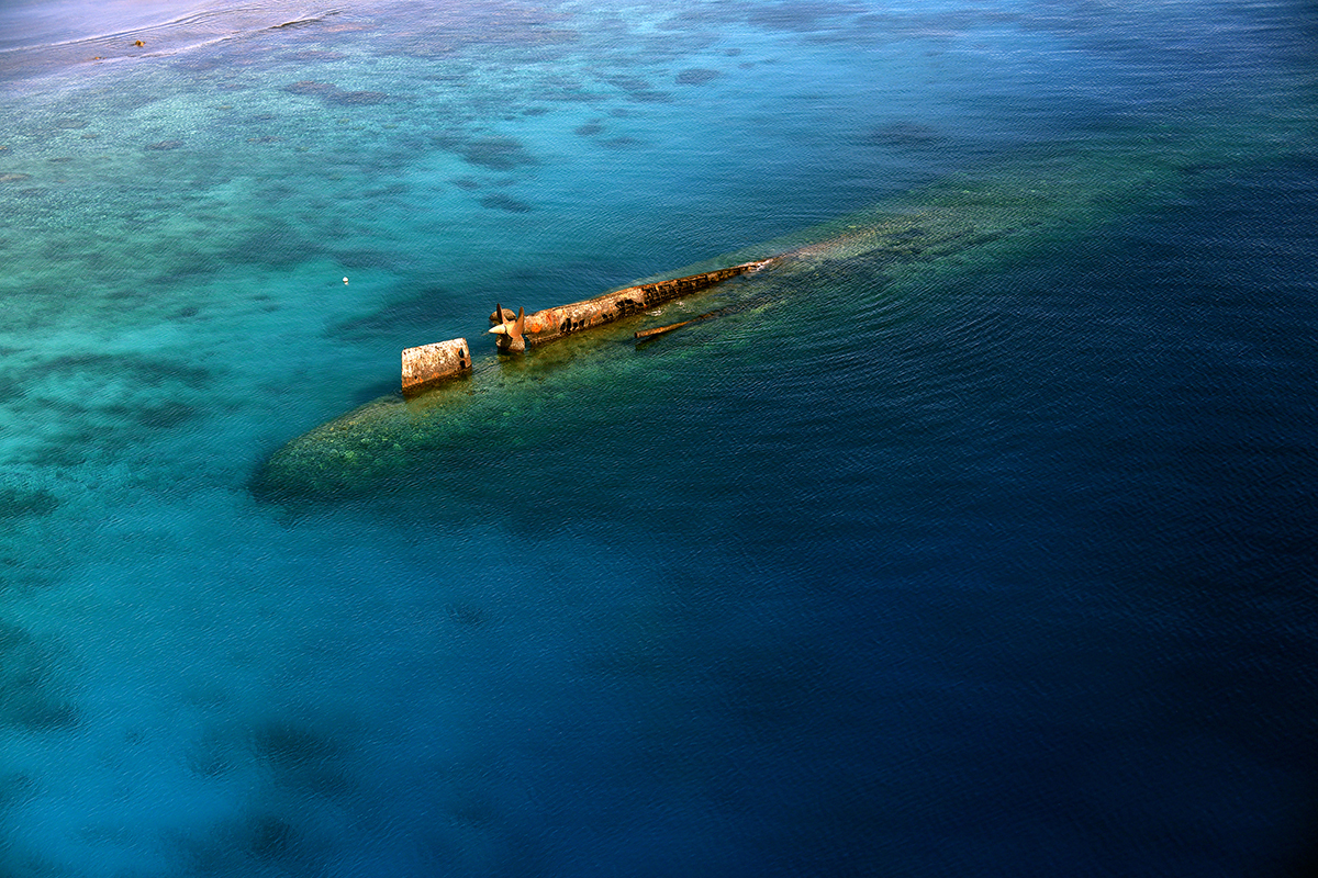
The U.S. Army has hosted an army base on Kwajalein Island since World War II. It was the final resting place of the German cruiser Prinz Eugen after it survived the Operation Crossroads nuclear test in 1946. In the late 1950s, the U.S. Army took over the base as part of their Nike Zeus anti-ballistic missile efforts, and since then the atoll has been widely used for missile tests of all sorts. Today it is part of the Ronald Reagan Ballistic Missile Defense Test Site, with various radars, tracking cameras, missile launchers, and many support systems spread across many islands. One of the five ground stations used in controlling the operation of the Global Positioning System (GPS) navigation system is located on Kwajalein.
The Marshall Islands are a dependent nation through the Free Compact of Association with the United States, after their independence established in the 1980s from a U.N. Protectorate. The defense of the Kwajalein, and the Marshall Islands is the responsibility of the United States. The important missile test range has been a mutually agreed task, and many Marshalese work at the military bases.

The atoll is also used as a base for orbital rocket launches with the Pegasus-XL rocket, and previously had a base for SpaceX for their Falcon 1 rocket.
Geography
Kwajalein is the 14th largest coral atoll as measured by area of enclosed water. Comprising 97 islands and islets, it has a land area of 16.4 km2 (6.3 sq mi) and surrounds one of the largest lagoons in the world, with an area of 2,174 km2 (839 sq mi). The average height above sea level for all the islands is about 1.8 m (6 ft).
The atoll was formed when volcanoes on the seabed from 165 to 76 mya built up enough lava that the land rose from beneath the sea. It cannot be determined how far above sea level the original land rose. Then coral started growing around the land/volcano, about 56 mya. Then the land subsided, leaving the coral ring of the atoll. The water temperature averages 27 °C (81 °F) degrees. Underwater visibility is typically 30 m (100 ft) on the ocean side of the atoll.

The atoll has an extended oval shape, running roughly WNW-ESE on the western side and then bending to run almost due south on the eastern side. It is bordered by its three largest islands, Ebadon, Roi-Namur, and Kwajalein, located at the extreme western, northern, and southern points, respectively. Roi-Namur is about 70 km (43 mi) east of Ebadon and 80 km (50 mi) NWN of Kwajalein. The atoll is 3,400 km (2,100 mi) from Honolulu, 3,200 km (2,000 mi) from Australia, and 3,400 km (2,100 mi) from Japan. Kwajalein Island is about 800 km (500 mi) north of the equator.
Islands often have alternate names: The first is the Marshallese name, the second was assigned somewhat arbitrarily by the U.S. Navy prior to their attack on the atoll during World War II. The original name was considered too difficult for English speakers to properly differentiate among the islands. The latter has often been retained by English speakers. The exception to this is Kwajalein itself, which is close to the native name; the received spelling, however, is from German.
Kwajalein Island
Kwajalein Island is the southernmost and largest of the islands in the atoll. The area is about 3.1 km2 (1.2 mi2). It is 4.0 km (2.5 mi) long and averages about 730 m (800 yd) wide. To enlarge the island, the Americans placed fill at both the northwestern part of the island above the pier (within the atoll, by 1953), the northern part extending towards Ebeye, and the southwestern parts of the island (by 1970). The northern extension was used for housing, while the remainder was used for industrial purposes.

Kwajalein Island's population is about 1,000, mostly made up of Americans with a small number of Marshall Islanders and other nationalities, all of whom require express permission from the U.S. Army to live there. Some 13,500 Marshallese citizens live on the atoll, most of them on Ebeye Island.
Passes near Kwajalein Island
SAR Pass (Search And Rescue Pass) is the closest to Kwajalein on the West Reef. This pass is man-made and was created in the mid-1950s. It is very narrow and shallow compared to the natural passes in the lagoon, and is used only by small boats.
South Pass is on the West Reef, north of SAR Pass. It is very wide.

Gea Pass is a deep water pass between Gea and Ninni islands.
Bigej Pass is the first pass on the East reef north of Kwajalein and Ebeye.
Other large islands
Other islands in the atoll:

Ebeye is about 7.2 km (4.5 mi) north of eastern end of Kwajalein Island. It is not part of the Reagan Test Site; it is a Marshallese island-city with shops, restaurants, and an active commercial port. It is the administrative center of the Republic of the Marshall Islands at Kwajalein Atoll and the Kwajalein Atoll Local Government (KALGOV). It has the largest population in the atoll, with approximately 13,000 residents living on 32 ha (80 acres) of land. Inhabitants are mostly Marshall Islanders but include a small population of migrants and volunteers from other island groups and nations.
Ebeye is one of the most densely populated places in the world. Many of its residents live in poverty. A coral reef (visible and able to be traveled at low tide) links them to Kwajalein and the rest of the outside world. A causeway at the northern end of the island provides a roadway that connects to several other islands, forming a chain of inhabited islands about 10 km (6.2 mi) long. Connected islands include Loi, Shell, and Gugeegue.
Ebadon (Epatōn, [ɛbʲɑdˠʌnʲ]) is located at the westernmost tip of the atoll. It was the second-largest island in the atoll before the formation of Roi-Namur. Like Ebeye, it falls fully under the jurisdiction of the Republic of the Marshall Islands and is not part of the Reagan Test Site. The village of Ebadon was much more heavily populated before the war, and it was where some of the irooj (chiefs) of Kwajalein Atoll grew up. Like many other key islets in the atoll, it has significant cultural and spiritual significance in Marshallese cosmology.
Roi-Namur is the northernmost island in the atoll, located some distance north of Kwajalein. It has several radar installations and a small residential community of unaccompanied U.S. personnel who deal with mission support and radar tracking. It also has a number of Japanese bunkers and buildings from World War II which are preserved in good condition. Roi-Namur used to be four islands: Roi, Namur, Enedrikdrik (Ane-dikdik), and Kottepina. Roi and Namur were joined by a causeway built by forced laborers working under the Japanese military; it was filled with sand that was dredged from the lagoon by both the Japanese and later American administrations between 1940 and 1945. After the war, the resulting conjoined islands were renamed Roi-Namur. There is a significant indigenous Marshall Islander workforce that commutes from the nearby island of Ennubirr to Roi-Namur, much as workers commute from Ebeye to Kwajalein. These workers are badged and have limited access to the island, although access is granted for islanders who need to use the air terminal to fly to Kwajalein.
Smaller islands
Eastern side
Little Bustard (Orpāp, [worˠ(ɤ)bʲæpʲ]) and Big Bustard (Epjā-dik, [ɛbʲ(ɛ)zʲæːrʲik], 'little Ebeye') are the first and second islets respectively north of Kwajalein island on the East reef, and are the only islets between Kwajalein and Ebeye. During low tide and with protective boots, it is possible to wade across the reef between Kwajalein and Little Bustard.
Gugeegue or Gugegwe ( GOO-jee-goo; Marshallese: Kōn̄e-jekāān-eņ, [kɤŋeːzʲɛɡæːnʲɛːnˠ]) is an islet north of Ebeye and is the northernmost point of the concrete causeway connecting the islets between them. Gugeegue is just south of the Bigej Pass, which separates it from the Bigej islet.
Bigej, just north of the Ebeye chain, is covered with tropical palm trees and jungle. People from Kwajalein have visited it for picnics and camping. It is a site of cultural significance to the indigenous people of Kwajalein Atoll, as are most of the small islands throughout the atoll. Some Kwajalein atoll landowners have proposed developing Bigej to look similar to the landscaped beauty of Kwajalein islet, for the exclusive use of Kwajalein atoll landowners and their families.
Meck is about 31 km (19 mi) north of Kwajalein. It is a launch site for anti-ballistic missiles and is probably the most restricted island of all the U.S.-leased sites. It was originally built up as part of the Nike-X program, as the main island of Kwajalein was already filled with equipment from the earlier Nike Zeus program, some of which remained in use during Nike-X testing. A large berm was built on the northern end of the island to support the missile silos, while a Missile Site Radar was built to its south, on the western side. An airstrip, somewhat longer than 300 m (1,000 ft) running north–south at the southeastern end of the island provided STOL service to the base, although the strong prevailing winds from the west made for very tricky landings. Air service was later deemed too dangerous and replaced by helicopter pads at either end of the runway. After the Army's main ABM programs shut down in the 1970s, Meck has served as the primary launch site for a variety of follow-on programs, including the Homing Overlay Experiment and THAAD, among many others.
Omelek, about 5 km (3.1 mi) north of Meck, is uninhabited and leased by the U.S. military. From 2006 to 2009, SpaceX used it to launch five Falcon 1 rockets.
Western side
Enubuj (Āne-buoj, [ænʲeːbˠuotʲ]), or "Carlson" Islet, which was its 1944 World War II U.S. operation codename, is situated next to Kwajalein to the northwest, directly west of Little Bustard. It was from this island that U.S. forces launched their amphibious invasion of Kwajalein Island. Today, it is the site of a small Marshallese village, a church, and a small cemetery. The sunken vessel Prinz Eugen, used during the Bikini Atoll atomic weapons tests, is along the islet's northern lagoon side.
Ennylabegan (Āneeļļap-kaņ, [ænʲeːllˠɑbʲ(ɛ)ɡɑnˠ]), or "Carlos" Islet, is the site of a small Marshall Islander community that has decreased in size in recent decades; it was once a bigger village. Until 2012, it was actively used by the Reagan Test Site for telemetry tracking activities during missions and has been one of the only non-restricted Marshallese-populated islands used by the United States Army. As such, power and clean drinking water were provided to half of the island, similar to the other military-leased islands. This has been phased out as the island no longer serves as a mission support site. The power plant, which also performed water treatment, is no longer in use.
Legan (Am̧bo, [ɑmbˠo]) is uninhabited, but it has a few buildings on the southern part. Most of the island is thick and jungle-covered, like most in the Marshall Islands. Unlike most islands, Legan has a very small lake in the middle.
Illeginni was used as a remote launch site for Sprint and Spartan missiles during the 1970s, with Meck as the primary control center. Coral soil dredged from the northeastern tip of the island was piled up to build a berm supporting the missile launchers. Several remotely controlled tracking cameras and other devices were also built on the island and serviced by boats or helicopters landing on a pad at the western end of the island. Today, a single tracking camera remains in use, along with telemetry equipment to support it. Illeginni was used successfully for the first Minuteman III missile land impact test in 1980. It also hosts one of the two remote receivers for the Tradex radar, the other being on Gellinam, with the main radar on Roi-Namur.
Nell has a unique convergence of protected channels and small islands. The Nell area is unique and a popular destination for locals and Americans sailing through it, provided they have proper permission from the Republic of the Marshall Islands (all non-leased islands are strictly off-limits to American base residents and personnel without prior permission).
Enmat (Enm̧aat, [ɛnʲ(ʌ)mˠɑːtˠ]), birthplace of the Irooj (chiefly families) is mo̧ or taboo, and therefore off-limits to anyone without the blessing of the Iroijlaplap (paramount chief). The remains of a small Marshallese village and burial sites are still intact. This island is in the Mid-Atoll Corridor, and no one can reside there or on the surrounding islands due to missile tests.
Wrecks in the lagoon
Because of the Battle of Kwajalein of World War II, the lagoon contains the wrecks of many ships and aircraft. Most of the ships were merchant vessels.
Concrete barge Chromite (BCL-2570) – deliberately sunk as a breakwater near Ennylabegan (Carlos)
Prinz Eugen – sunk by accident near Enubuj (Carlson) after a post-war atomic bomb test
Akibasan Maru – Japanese 4,607-ton freighter below "P-buoy" with the actual buoy marker no longer there. Sunk 30 January 1944.
Ikuta Maru – 2,968-ton Japanese freighter at "P-North" just north of the now missing P-buoy. This is listed as being one of the transports for Allied prisoners of war during World War II.
Unidentified wreck at G-buoy, 35 m (115 ft) in length
Tateyama Maru, K-5 side
Asakaze Maru, K-5 upright
Tyoko Maru (or Choko Maru), a 3,535-ton freighter, at Barracuda Junction. Sunk December 5, 1943.
Barge, between South Carlson and Sar Pass
Wooden auxiliary sub chaser wreck near South Pass. The wooden hull has almost completely deteriorated.
Shonan Maru #6, grounded at Gebh Island to avoid sinking but blown up
Shell (or Ebwaj) Island wreck. 34 m (110 ft) trawler or whaler.
South Shell wreck, similar to the Shell Island wreck
Daisan Maru, a former whaler, near Bigej Pass
Palawan, an engine freighter captured by the Japanese during the Battle of the Philippines. Sunk by the U.S. destroyer Harrison January 31, 1944, near Bigej.
Shoei Maru, a sunken freighter resting upside down at the O-buoy
A Japanese aircraft just west of Ebeye
A Martin PBM Mariner about 1 nautical mile west of Ebeye
Four North American B-25 Mitchells, a Grumman TBF Avenger, a Vought F4U Corsair, four Douglas SBD Dauntlesses, and a Curtiss C-46 Commando in the western reef inside Roi-Namur
Barracuda Junction is about 1.6 km (1 mi) northeast of the southern tip of Enubuj (Carlson) Island.
Climate
The atoll has a tropical rainforest climate under the Köppen climate classification. The average temperature varies less than 1.1 °C (2 °F) from month to month. The record low from 1950 to 1969 was 21 °C (70 °F). The highest temperature was 36 °C (97 °F).