
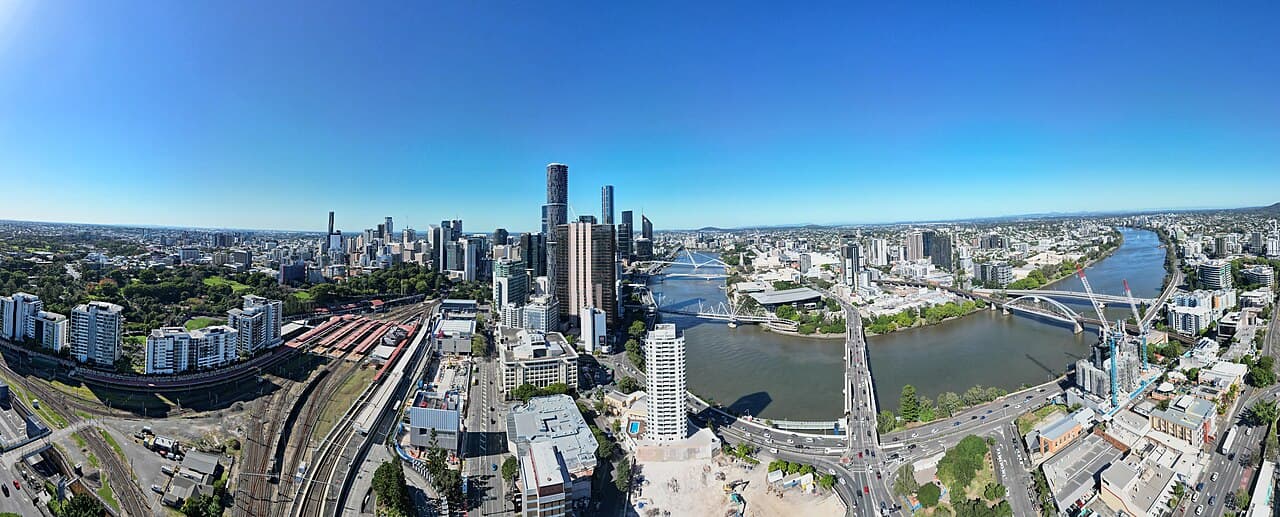
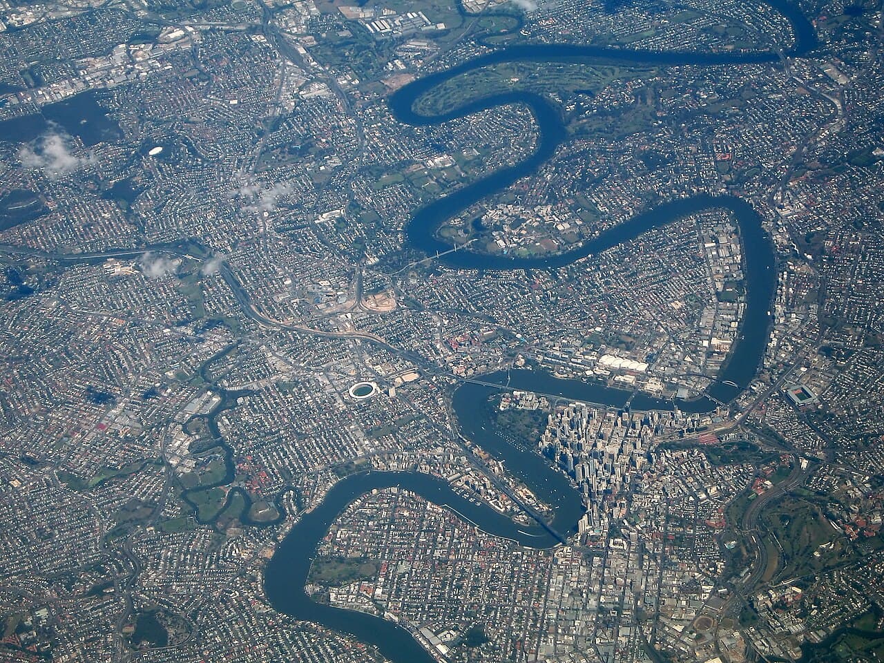
The Brisbane River (Turrbal: Maiwar) is the longest river in South East Queensland, Australia. It flows through the city of Brisbane, before emptying into Moreton Bay on the Coral Sea. John Oxley, the first European to explore the river, named it after the Governor of New South Wales, Sir Thomas Brisbane in 1823. The penal colony of Moreton Bay later adopted the same name, eventually becoming the present city of Brisbane. The river is a tidal estuary and the water is brackish from its mouth through the majority of the Brisbane metropolitan area westward to the Mount Crosby Weir. The river is wide and navigable throughout the Brisbane metropolitan area. It is affectionately known by locals as the "Brown Snake", on account of its silty waters and long, winding course.
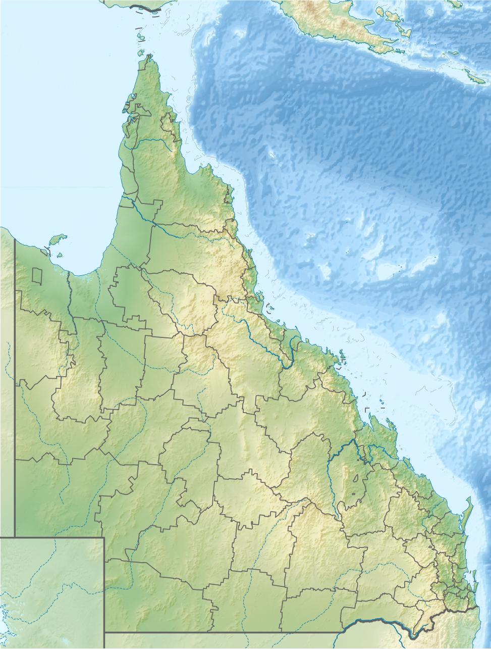
The river travels 344 km (214 mi) from Mount Stanley. The river is dammed by the Wivenhoe Dam, forming Lake Wivenhoe, the main water supply for Brisbane. The waterway is a habitat for the rare Queensland lungfish, Brisbane River cod (extinct), and bull sharks.
Early travellers along the waterway admired the natural beauty, abundant fish and rich vegetation along its banks. From 1862 the Brisbane River has been dredged for navigation purposes. The river served as an important carriageway between Brisbane and Ipswich before a railway linking the towns was built in 1875. By the late 1920s, water quality in the river had significantly deteriorated.

Multiple major floods occurred in 1893. In 1974, the most damaging flood on record occurred, causing the 66,000-tonne vessel Robert Miller (largest ship ever built on the river) to break free from its mooring. Other major floods occurred in January 2011 and February 2022.
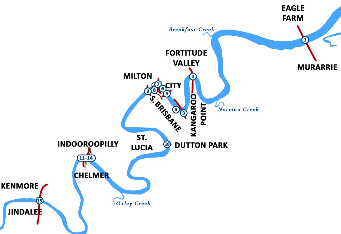
Extensive port facilities have been constructed on the Fisherman Islands, now known as the Port of Brisbane, located at the mouth of the river on Moreton Bay. There are 16 major bridges that cross the river. The Clem Jones Tunnel, opened in 2010, is the river's first underground crossing for road transport. The CityCat and KittyCat ferry services deliver passengers along the inner-city reaches of the river.
Name
In 1823 John Oxley named the river after the Governor Thomas Brisbane while surveying the area to locate a new penal settlement. The name is of Scottish origin, dating from at least 1643, from their family lands at Rothiebrisbane, Aberdeenshire. This is the name now used by the Queensland Government.
Maiwar is the name of the river in the Turrbal language (the language of an Aboriginal group native to the Brisbane area). The name is also used for the inner-western state electorate of Maiwar.
According to Archibald Meston and Tom Petrie in 1901, the Aboriginal people of the Brisbane area did not have a single name for the river, but rather they named individual reaches and bends.
Course
The Brisbane River East and West branches traditionally have their headwaters in the ranges east of Kingaroy. The two branches merge into a single watercourse south of Mount Stanley. Using an alternative modern definition, the source is located at the top of Fig Tree Gully in the Bunya Mountains, which are the headwaters of the river's longest tributary Cooyar Creek. Water from the highest point in the catchment has fallen on the Bunya Mountains, 992m above sea level.
The junction of Cooyar Creek and Brisbane River is south of Avoca Vale, and the river then makes its way south past townships including Linville, Moore and Toogoolawah before being joined by the Stanley River, just south of Somerset Dam.
The river runs from there into Lake Wivenhoe, created by the Wivenhoe Dam. Beyond the dam, the river meanders eastward, meeting the Bremer River near Ipswich, then making its way through Brisbane's western suburbs, including Jindalee, Indooroopilly and Toowong.
The Brisbane River then flows past wharves including Pinkenba Wharf and Portside Wharf, past Bulwer Island and Luggage Point through the Port of Brisbane and into southern Bramble Bay an embayment of Moreton Bay.
Kangaroo Point Cliffs
On the southern side of the river, opposite Gardens Point, are the Kangaroo Point Cliffs; made from Triassic aged volcanic rock of rhyolite composition called Brisbane tuff. The Kangaroo Point Cliffs were created by a quarrying operation that, according to Allan Cunninghams' Field Book, was underway prior to 1829 when he observed a "stone wharf presumably used for landing the blocks of stone ferried across the river for the construction of buildings in the settlement". This was in the vicinity of Edward Street ferry terminal. Quarrying this volcanic rock formed part of the hard labour undertaken by the convicts of the Moreton Bay Penal Settlement, which not only provided the convicts with the punishment of hard labour but also provided the settlement with a useful building material. Many of the early buildings including the Commissariat Store, Brisbane were built by convicts using tuff from this quarry. After the penal settlement was closed, the Petrie family leased the cliffs and quarried the tuff for use in their construction projects, but ultimately quarrying this material became uneconomic without the free labour of the convicts.
The volcanic rock Ignimbrite which formed the cliffs was deposited in the Triassic period about 220 million years ago. They currently form the banks of the Brisbane River.
Reaches
A number of the reaches of the Brisbane River are named, including the following listed below (from upstream to downstream), together with their location relative to tributaries of the river and river crossings:
Tributaries
The following major tributaries flow into the Brisbane River from the north; Breakfast Creek, Moggill Creek and the Stanley River. On the southside Bulimba Creek, Norman Creek, Oxley Creek, Bremer River and Lockyer Creek waterways enter the Brisbane River. The following smaller creeks also flow into the river; Cressbrook Creek, Cooyar Creek, Cubberla Creek, Black Snake Creek, Wolston Creek, Woogaroo Creek, Goodna Creek, Six Mile Creek, Pullen Pullen Creek and Kholo Creek.
History
Before European settlement, the Brisbane River was spiritually important and a vital food source for the Aboriginal people of the Turrbal people, primarily through fishing in the tidal sections downstream. Additionally, fishing and fire-stick farming took place in the upper reaches of the river where there was freshwater, in some seasons.
Four European navigators, namely James Cook, Matthew Flinders, John Bingle and William Edwardson, all visited Moreton Bay but failed to discover the river. The exploration by Flinders took place during his expedition from Port Jackson north to Hervey Bay in 1799. He spent a total of 15 days in the area, touching down at Woody Point and several other spots, but failed to discover the mouth of the river although there were suspicions of its existence. This is consistent with accounts of many other rivers along the east coast of Australia, which could not be found by seaward exploration but were discovered by inland travellers.
On 21 March 1823, four ticket-of-leave convicts sailing south from Sydney on a timber getting mission to Illawarra, Thomas Pamphlett, John Finnegan, Richard Parsons and John Thompson were blown north by a storm. They went 21 days without water, continuing north in the belief they had been blown south, during which time Thompson died. They landed on Moreton Island on 16 April and made it to the mainland on the south of the Brisbane River. They immediately began trekking north in order to return to Sydney, still believing themselves to be somewhere south of Jervis Bay. Subsequently, they became the first known Europeans to discover the river, stumbling across it somewhere near the entrance. They walked upstream along its banks for nearly a month before making their first crossing at Canoe Reach, the junction of Oxley Creek. It was here they stole a small canoe left by the Turrbal people of the region.
John Oxley was Surveyor General of New South Wales when, in the same year and under orders from Governor Brisbane, he sailed into Moreton Bay looking for a suitable new site for a convict settlement to be established. An entry in Oxley's diary on 19 November 1823 describes his surprise meeting with one of the shipwrecked men:
"We rounded the Point Skirmish about 5 o'clock and observed a number of natives running along the beach towards the vessel, the foremost much lighter in colour than the rest. We were to the last degree astonished when he came abreast the vessel to hear him hail us in good English."
By that time Pamphlett and Finnegan were living with natives near Bribie Island. Parsons, who had continued to travel north in search of Sydney, was picked up by Oxley on 11 September 1824.
On 2 December 1823, Oxley and Stirling, with Finnegan as a somewhat reluctant guide, entered the river and sailed upstream as far as present-day Goodna. Oxley noted the abundant fish and tall pine trees. Early European explorers marvelled at the sheer natural beauty they witnessed while travelling up the lower reaches.
Reports by early European explorers such as Allan Cunningham and Oxley indicate rainforest once fringed the Brisbane River and its major tributaries, especially on the broader floodplains such as St Lucia and Seventeen Mile Rocks. The coastal lowlands were extensively vegetated with Melaleuca woodlands in low lying, poorly drained coastal areas. When first described by Europeans, the lower reaches of the Brisbane River were fringed by a mosaic of open forest, closed forest and rainforest.
In the same year of 1823, the river was named after Sir Thomas Brisbane, the then Governor of New South Wales. Upon the establishment of a local settlement in 1824, other explorers such as Allan Cunningham, Patrick Logan and Major Edmund Lockyer made expeditions and surveys further upstream, and, in May 1825, the Moreton Bay penal colony at Redcliffe under the command of Heny Miller relocated to North Quay.
The entrance to the Brisbane River was surveyed and marked with buoys in May 1825 by Pilot John M Gray sent from Sydney for the purpose by Governor Sir Thomas Brisbane. Gray also transferred the soldiers and convicts from the First Settlement at Redcliffe at this time. The first small private wharves were built on the river in about 1848. and the once popular, shark-proof river baths were first built in 1857 at Kangaroo Point. By 1850, nearly all the prime alluvial lands in the Brisbane River valley had been taken up by settlers.
From 1862 the Brisbane River has been dredged for navigation purposes. Throughout much of the 20th century large quantities of sand and gravel were extracted from the estuary of the river. Since the rate of materials being deposited is not as high as that which was removed, the river has acted as a subaqueous mine.
In 1865, water police were stationed on board Proserpine, a hulk moored at the mouth of the Brisbane River.
In 1866, there was a breakwater built at the junction of the Bremer and Brisbane rivers that was designed to stop shingle from blocking the access to the Bremer's boat channel. The first pile light using kerosene was built in 1882. The steel framed light also served as an early port signal station.
In February 1896, one of the river's worst disasters occurred with the capsize of the ferry Pearl (which struck the anchor chain of the government yacht Lucinda) with the loss of around 40 lives.
20th century
By 1928, due to the early settlement of Brisbane, the water quality had deteriorated to the point where several public baths had to cease sourcing water from the river. Yet even up to the 1930s, the water was said to be very clear, with reports of people seeing the river bed 5 to 6 m (16 to 20 ft) below the surface. Swimming was once popular at Oxley Point under the Walter Taylor Bridge. In the middle tidal reaches in more recent times, visibility has been about 0.2 m (8 in). As Brisbane grew, the condition of the river worsened until at its worst it was no more than an open sewer and waste dump. The banks were cleared of timber and introduced animals and plants rapidly changed the river's ecology to its detriment.
On 25 March 1941, a USA goodwill flotilla arrived in the city docking at wharves along the river and built Naval Base Brisbane. The largest ship built on the river was the Robert Miller. Construction was near complete when the 66,000 tonne vessel became un-moored in the 1974 Brisbane flood. In 1977, Queen Elizabeth II switched on the Jubilee Fountain positioned in front of the proposed Queensland Cultural Centre. The jets pushed the floodlit river water up to 75 m (246 ft) in the air. The floating fountain sank late on the 31 December 1984. 1987 was proclaimed the "Year of the River" by the Lord Mayor of Brisbane at the time, Sallyanne Atkinson.
Over the 20th century, enough obstacles, sand and gravel had been removed from the river that its channel depth increased the tidal flow and tidal range upstream.
21st century
On 9 August 2020, it was discovered that Google Maps accidentally changed the Brisbane River name to Ithaca Creek after a complaint that Ithaca Creek was incorrectly named Brisbane River.
Floods
The Brisbane River floods frequently, although the occurrence and magnitude of flooding has diminished following the construction of the Wivenhoe Dam on the upper reaches of the river.
Past floods have resulted in both deepening and reduction in river depth, creation of new sand banks and shoals as well as increased transport of suspended sediment from upstream. Before the invention of modern dredging techniques the sediment deposited by flooding created hazards to ships navigating the river. Even medium-sized vessels no longer travel up the Brisbane River beyond the city reach, and dredging of the upper reaches has ceased, allowing the river to recover substantially from the fine silt dislodged by gravel and sand extraction.
Significant floods have occurred several times since the European settlement of Brisbane. There have been 12 Major flood peaks (over 3.5m) recorded at the Brisbane gauge since records began in 1841, including:
14 January 1841, with a maximum river level of 8.43m at the gauge, the highest flood level recorded to date
10 January 1844, 7.1m flood peak at Brisbane.
February 1863, 3.8m flood peak
January 1887, 3.8m flood peak
July 1889, 3.8m flood peak
March 1890, 5.3m flood peak
February 1893, a sequence of flood peaks (8.35 metres and 8.09 metres) over two weeks saw the highest recorded flood level in the Brisbane central business district. Seven lives were lost in the Eclipse Colliery at North Ipswich as a direct result of the flooding. Several other people drowned as well.
June 1897, 5.0m flood peak
February 1907, 3.6m flood peak
27 January 1974, the largest flood to affect Brisbane City in the 20th Century, with a level of 5.45 metres
Post construction of Wivenhoe Dam
11 January 2011 with a level of 4.45 metres
28 February 2022, 4.0m flood peak
Flooding along the Brisbane River has the potential to be devastating, as documented in 1974, 2011 and 2022. For much of the river's length its banks are relatively high, but topped by a broad plain. The river's meandering course means that flood waters from upstream cannot be quickly discharged into Moreton Bay. Thus higher than normal flows cause river levels to rise rapidly and once the top of the banks are breached the floodwaters can spread over wide areas of the city.