
The Amazon River (UK: , US: ; Portuguese: rio Amazonas, Spanish: río Amazonas) in South America is the largest river by discharge volume of water in the world, and the second-longest or longest river system in the world, a title which is disputed with the Nile.
The headwaters of the Apurímac River on Nevado Mismi in Peru had been considered, for nearly a century, the Amazon basin's most distant source until a 2014 study found it to be the headwaters of the Mantaro River on the Cordillera Rumi Cruz in Peru. The Mantaro and Apurímac rivers join, and with other tributaries form the Ucayali River, which in turn meets the Marañón River upstream of Iquitos, Peru, forming what countries other than Brazil consider to be the main stem of the Amazon. Brazilians call this section the Solimões River above its confluence with the Rio Negro forming what Brazilians call the Amazon at the Meeting of Waters (Portuguese: Encontro das Águas) at Manaus, the largest city on the river.
The Amazon River has an average discharge of about 215,000 to 230,000 cubic meters per second (7,600,000 to 8,100,000 cu ft/s)—approximately 6,591 to 7,570 cubic kilometers (1,581 to 1,816 cu mi) per year, greater than the next seven largest independent rivers combined. Two of the top ten rivers by discharge are tributaries of the Amazon river. The Amazon represents 20% of the global riverine discharge into oceans. The Amazon basin is the largest drainage basin in the world, with an area of approximately 7,000,000 square kilometers (2,700,000 sq mi). The portion of the river's drainage basin in Brazil alone is larger than any other river's basin. The Amazon enters Brazil with only one-fifth of the flow it finally discharges into the Atlantic Ocean yet already has a greater flow at this point than the discharge of any other river in the world. It has a recognized length of 6,400 kilometers (4,000 mi), but according to some reports, its length varies from 6,575 to 7,062 kilometers (4,086 to 4,388 mi).
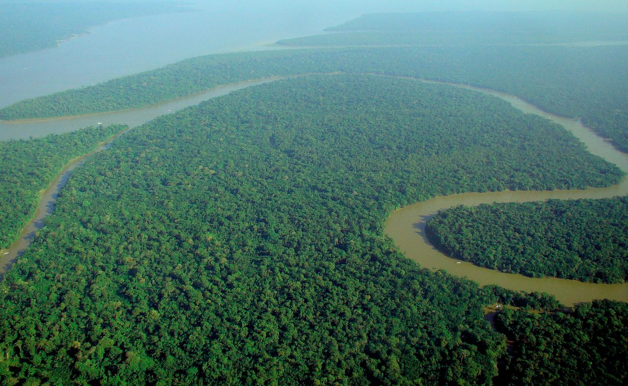
Etymology
The Amazon was initially known by Europeans as the Marañón, and the Peruvian part of the river is still known by that name, as well as the Brazilian state of Maranhão, which contains part of the Amazon. It later became known as Rio Amazonas in Spanish and Portuguese.
The name Rio Amazonas was reportedly given after native warriors attacked a 16th-century expedition by Francisco de Orellana. The warriors were led by women, reminding de Orellana of the Amazon warriors, a tribe of women warriors related to Iranian Scythians and Sarmatians mentioned in Greek mythology.
The word Amazon itself may be derived from the Iranian compound * ha-maz-an- "(one) fighting together" or ethnonym * ha-mazan- "warriors", a word attested indirectly through a derivation, a denominal verb in Hesychius of Alexandria's gloss "ἁμαζακάραν· πολεμεῖν. Πέρσαι" ("hamazakaran: 'to make war' in Persian"), where it appears together with the Indo-Iranian root * kar- "make" (from which Sanskrit karma is also derived).

History
Geological history
Geological studies suggest that for millions of years, the Amazon River flowed in the opposite direction – from east to west. Eventually the Andes Mountains formed, blocking its flow to the Pacific Ocean and causing it to switch directions to its current mouth in the Atlantic Ocean.
Pre-Columbian era
During what many archaeologists called the formative stage, Amazonian societies were deeply involved in the emergence of South America's highland agrarian systems. The trade with Andean civilizations in the terrains of the headwaters in the Andes formed an essential contribution to the social and religious development of higher-altitude civilizations like the Muisca and Incas. Early human settlements were typically based on low-lying hills or mounds.
Shell mounds were the earliest evidence of habitation; they represent piles of human refuse and are mainly dated between 7500 BC and 4000 BC. They are associated with ceramic age cultures; no preceramic shell mounds have been documented so far by archaeologists. Artificial earth platforms for entire villages are the second type of mounds. They are best represented by the Marajoara culture. Figurative mounds are the most recent types of occupation.

There is ample evidence that the areas surrounding the Amazon River were home to complex and large-scale indigenous societies, mainly chiefdoms who developed towns and cities. Archaeologists estimate that by the time the Spanish conquistador De Orellana traveled across the Amazon in 1541, more than 3 million indigenous people lived around the Amazon. These pre-Columbian settlements created highly developed civilizations. For instance, pre-Columbian indigenous people on the island of Marajó may have developed social stratification and supported a population of 100,000 people. To achieve this level of development, the indigenous inhabitants of the Amazon rainforest altered the forest's ecology by selective cultivation and the use of fire. Scientists argue that by burning areas of the forest repeatedly, the indigenous people caused the soil to become richer in nutrients. This created dark soil areas known as terra preta de índio ("Indian black earth"). Because of the terra preta, indigenous communities were able to make land fertile and thus sustainable for the large-scale agriculture needed to support their large populations and complex social structures. Further research has hypothesized that this practice began around 11,000 years ago. Some say that its effects on forest ecology and regional climate explain the otherwise inexplicable band of lower rainfall through the Amazon basin.
Many indigenous tribes engaged in constant warfare. According to James S. Olson, "The Munduruku expansion (in the 18th century) dislocated and displaced the Kawahíb, breaking the tribe down into much smaller groups ... [Munduruku] first came to the attention of Europeans in 1770 when they began a series of widespread attacks on Brazilian settlements along the Amazon River."
Arrival of Europeans
In March 1500, Spanish conquistador Vicente Yáñez Pinzón was the first documented European to sail up the Amazon River. Pinzón called the stream Río Santa María del Mar Dulce, later shortened to Mar Dulce, literally, sweet sea, because of its freshwater pushing out into the ocean. Another Spanish explorer, Francisco de Orellana, was the first European to travel from the origins of the upstream river basins, situated in the Andes, to the mouth of the river. In this journey, Orellana baptized some of the affluents of the Amazonas like Rio Negro, Napo and Jurua.

The name Amazonas is thought to be taken from the native warriors, mostly women, whose attack on this expedition reminded De Orellana of the mythical female Amazon warriors from the ancient Hellenic culture in Greece (see also Origin of the name).
Exploration
Gonzalo Pizarro set off in 1541 to explore east of Quito into the South American interior in search of El Dorado, the "city of gold" and La Canela, the "valley of cinnamon". He was accompanied by his second-in-command Francisco de Orellana. After 170 km (106 mi), the Coca River joined the Napo River (at a point now known as Puerto Francisco de Orellana); the party stopped for a few weeks to build a boat just upriver from this confluence. They continued downriver through an uninhabited area, where they could not find food. Orellana offered and was ordered to follow the Napo River, then known as Río de la Canela ("Cinnamon River"), and return with food for the party. Based on intelligence received from a captive native chief named Delicola, they expected to find food within a few days downriver by ascending another river to the north.
De Orellana took about 57 men, the boat, and some canoes and left Pizarro's troops on 26 December 1541. However, De Orellana missed the confluence (probably with the Aguarico) where he was searching supplies for his men. By the time he and his men reached another village, many of them were sick from hunger and eating "noxious plants", and near death. Seven men died in that village. His men threatened to mutiny if the expedition turned back to attempt to rejoin Pizarro, the party being over 100 leagues downstream at this point. He accepted to change the purpose of the expedition to discover new lands in the name of the king of Spain, and the men built a larger boat in which to navigate downstream. After a journey of 600 km (370 mi) down the Napo River, they reached a further major confluence, at a point near modern Iquitos, and then followed the upper Amazon, now known as the Solimões, for a further 1,200 km (750 mi) to its confluence with the Rio Negro (near modern Manaus), which they reached on 3 June 1542.

Regarding the initial mission of finding cinnamon, Pizarro reported to the king that they had found cinnamon trees, but that they could not be profitably harvested. True cinnamon (Cinnamomum Verum) is not native to South America. Other related cinnamon-containing plants (of the family Lauraceae) are fairly common in that part of the Amazon and Pizarro probably saw some of these. The expedition reached the mouth of the Amazon on 24 August 1542, demonstrating the practical navigability of the Great River.
In 1560, another Spanish conquistador, Lope de Aguirre, may have made the second descent of the Amazon. Historians are uncertain whether the river he descended was the Amazon or the Orinoco River, which runs more or less parallel to the Amazon further north.
Portuguese explorer Pedro Teixeira was the first European to travel up the entire river. He arrived in Quito in 1637, and returned via the same route.

From 1648 to 1652, Portuguese Brazilian bandeirante António Raposo Tavares led an expedition from São Paulo overland to the mouth of the Amazon, investigating many of its tributaries, including the Rio Negro, and covering a distance of over 10,000 km (6,200 mi).
In what is currently in Brazil, Ecuador, Bolivia, Colombia, Peru, and Venezuela, several colonial and religious settlements were established along the banks of primary rivers and tributaries for trade, slaving , and evangelization among the indigenous peoples of the vast rainforest, such as the Urarina. In the late 1600s, Czech Jesuit Father Samuel Fritz, an apostle of the Omagus established some forty mission villages. Fritz proposed that the Marañón River must be the source of the Amazon, noting on his 1707 map that the Marañón "has its source on the southern shore of a lake that is called Lauricocha, near Huánuco." Fritz reasoned that the Marañón is the largest river branch one encounters when journeying upstream, and lies farther to the west than any other tributary of the Amazon. For most of the 18th–19th centuries and into the 20th century, the Marañón was generally considered the source of the Amazon.
Scientific exploration
Early scientific, zoological, and botanical exploration of the Amazon River and basin took place from the 18th century through the first half of the 19th century.
Charles Marie de La Condamine explored the river in 1743.
Alexander von Humboldt, 1799–1804
Johann Baptist von Spix and Carl Friedrich Philipp von Martius, 1817–1820
Georg von Langsdorff, 1826–1828
Henry Walter Bates and Alfred Russel Wallace, 1848–1859
Richard Spruce, 1849–1864
Post-colonial exploitation and settlement
The Cabanagem revolt (1835–1840) was directed against the white ruling class. It is estimated that from 30% to 40% of the population of Grão-Pará, estimated at 100,000 people, died.
The population of the Brazilian portion of the Amazon basin in 1850 was perhaps 300,000, of whom about 175,000 were Europeans and 25,000 were slaves. The Brazilian Amazon's principal commercial city, Pará (now Belém), had from 10,000 to 12,000 inhabitants, including slaves. The town of Manáos, now Manaus, at the mouth of the Rio Negro, had a population between 1,000 and 1,500. All the remaining villages, as far up as Tabatinga, on the Brazilian frontier of Peru, were relatively small.
On 6 September 1850, Emperor Pedro II of Brazil sanctioned a law authorizing steam navigation on the Amazon and gave the Viscount of Mauá (Irineu Evangelista de Sousa) the task of putting it into effect. He organised the "Companhia de Navegação e Comércio do Amazonas" in Rio de Janeiro in 1852; in the following year it commenced operations with four small steamers, the Monarca ('Monarch'), the Cametá, the Marajó and the Rio Negro.
At first, navigation was principally confined to the main river; and even in 1857 a modification of the government contract only obliged the company to a monthly service between Pará and Manaus, with steamers of 200 tons cargo capacity, a second line to make six round voyages a year between Manaus and Tabatinga, and a third, two trips a month between Pará and Cametá. This was the first step in opening up the vast interior.
The success of the venture called attention to the opportunities for economic exploitation of the Amazon, and a second company soon opened commerce on the Madeira, Purús, and Negro; a third established a line between Pará and Manaus, and a fourth found it profitable to navigate some of the smaller streams. In that same period, the Amazonas Company was increasing its fleet. Meanwhile, private individuals were building and running small steam craft of their own on the main river as well as on many of its tributaries.
On 31 July 1867, the government of Brazil, constantly pressed by the maritime powers and by the countries encircling the upper Amazon basin, especially Peru, decreed the opening of the Amazon to all countries, but they limited this to certain defined points: Tabatinga – on the Amazon; Cametá – on the Tocantins; Santarém – on the Tapajós; Borba – on the Madeira, and Manaus – on the Rio Negro. The Brazilian decree took effect on 7 September 1867.
Thanks in part to the mercantile development associated with steamboat navigation coupled with the internationally driven demand for natural rubber, the Peruvian city of Iquitos became a thriving, cosmopolitan center of commerce. Foreign companies settled in Iquitos, from where they controlled the extraction of rubber. In 1851 Iquitos had a population of 200, and by 1900 its population reached 20,000. In the 1860s, approximately 3,000 tons of rubber were being exported annually, and by 1911 annual exports had grown to 44,000 tons, representing 9.3% of Peru's exports. During the rubber boom it is estimated that diseases brought by immigrants, such as typhus and malaria, killed 40,000 native Amazonians.
The first direct foreign trade with Manaus commenced around 1874. Local trade along the river was carried on by the English successors to the Amazonas Company—the Amazon Steam Navigation Company—as well as numerous small steamboats, belonging to companies and firms engaged in the rubber trade, navigating the Negro, Madeira, Purús, and many other tributaries, such as the Marañón, to ports as distant as Nauta, Peru.
By the turn of the 20th century, the exports of the Amazon basin were India-rubber, cacao beans, Brazil nuts and a few other products of minor importance, such as pelts and exotic forest produce (resins, barks, woven hammocks, prized bird feathers, live animals) and extracted goods, such as lumber and gold.
20th-century development
Since colonial times, the Portuguese portion of the Amazon basin has remained a land largely undeveloped by agriculture and occupied by indigenous people who survived the arrival of European diseases.
Four centuries after the European discovery of the Amazon river, the total cultivated area in its basin was probably less than 65 km2 (25 sq mi), excluding the limited and crudely cultivated areas among the mountains at its extreme headwaters. This situation changed dramatically during the 20th century.
Wary of foreign exploitation of the nation's resources, Brazilian governments in the 1940s set out to develop the interior, away from the seaboard where foreigners owned large tracts of land. The original architect of this expansion was president Getúlio Vargas, with the demand for rubber from the Allied forces in World War II providing funding for the drive.
In the 1960s, economic exploitation of the Amazon basin was seen as a way to fuel the "economic miracle" occurring at the time. This resulted in the development of "Operation Amazon", an economic development project that brought large-scale agriculture and ranching to Amazonia. This was done through a combination of credit and fiscal incentives.
However, in the 1970s the government took a new approach with the National Integration Program (PIN). A large-scale colonization program saw families from northeastern Brazil relocated to the "land without people" in the Amazon Basin. This was done in conjunction with infrastructure projects mainly the Trans-Amazonian Highway (Transamazônica).
The Trans-Amazonian Highway's three pioneering highways were completed within ten years but never fulfilled their promise. Large portions of the Trans-Amazonian and its accessory roads, such as BR-317 (Manaus-Porto Velho), are derelict and impassable in the rainy season. Small towns and villages are scattered across the forest, and because its vegetation is so dense, some remote areas are still unexplored.
Many settlements grew along the road from Brasília to Belém with the highway and National Integration Program, however, the program failed as the settlers were unequipped to live in the delicate rainforest ecosystem. This, although the government believed it could sustain millions, instead could sustain very few.
With a population of 1.9 million people in 2014, Manaus is the largest city on the Amazon. Manaus alone makes up approximately 50% of the population of the largest Brazilian state of Amazonas. The racial makeup of the city is 64% pardo (mulatto and mestizo) and 32% white.
Although the Amazon river remains undammed, around 412 dams are in operation on the Amazon's tributary rivers. Of these 412 dams, 151 are constructed over six of the main tributary rivers that drain into the Amazon. Since only 4% of the Amazon's hydropower potential has been developed in countries like Brazil, more damming projects are underway and hundreds more are planned. After witnessing the negative effects of environmental degradation, sedimentation, navigation and flood control caused by the Three Gorges Dam in the Yangtze River, scientists are worried that constructing more dams in the Amazon will harm its biodiversity in the same way by "blocking fish-spawning runs, reducing the flows of vital oil nutrients and clearing forests". Damming the Amazon River could potentially bring about the "end of free flowing rivers" and contribute to an "ecosystem collapse" that will cause major social and environmental problems.
Course
Origins
The most distant source of the Amazon was thought to be in the Apurímac river drainage for nearly a century. Such studies continued to be published even as recently as 1996, 2001, 2007, and 2008, where various authors identified the snowcapped 5,597 m (18,363 ft) Nevado Mismi peak, located roughly 160 km (99 mi) west of Lake Titicaca and 700 km (430 mi) southeast of Lima, as the most distant source of the river. From that point, Quebrada Carhuasanta emerges from Nevado Mismi, joins Quebrada Apacheta and soon forms Río Lloqueta which becomes Río Hornillos and eventually joins the Río Apurímac.
A 2014 study by Americans James Contos and Nicolas Tripcevich in Area, a peer-reviewed journal of the Royal Geographical Society, however, identifies the most distant source of the Amazon as actually being in the Río Mantaro drainage. A variety of methods were used to compare the lengths of the Mantaro river vs. the Apurímac river from their most distant source points to their confluence, showing the longer length of the Mantaro. Then distances from Lago Junín to several potential source points in the uppermost Mantaro river were measured, which enabled them to determine that the Cordillera Rumi Cruz was the most distant source of water in the Mantaro basin (and therefore in the entire Amazon basin). The most accurate measurement method was direct GPS measurement obtained by kayak descent of each of the rivers from their source points to their confluence (performed by Contos). Obtaining these measurements was difficult given the class IV–V nature of each of these rivers, especially in their lower "Abyss" sections. Ultimately, they determined that the most distant point in the Mantaro drainage is nearly 80 km farther upstream compared to Mt. Mismi in the Apurímac drainage, and thus the maximal length of the Amazon river is about 80 km longer than previously thought. Contos continued downstream to the ocean and finished the first complete descent of the Amazon from its newly identified source (finishing November 2012), a journey repeated by two groups after the news spread.
After about 700 km (430 mi), the Apurímac then joins Río Mantaro to form the Ene, which joins the Perene to form the Tambo, which joins the Urubamba River to form the Ucayali. After the confluence of Apurímac and Ucayali, the river leaves Andean terrain and is surrounded by floodplain. From this point to the confluence of the Ucayali and the Marañón, some 1,600 km (990 mi), the forested banks are just above the water and are inundated long before the river attains its maximum flood stage. The low river banks are interrupted by only a few hills, and the river enters the enormous Amazon rainforest.
The Upper Amazon or Solimões
Although the Ucayali–Marañón confluence is the point at which most geographers place the beginning of the Amazon River proper, in Brazil the river is known at this point as the Solimões das Águas. The river systems and flood plains in Brazil, Peru, Ecuador, Colombia, and Venezuela, whose waters drain into the Solimões and its tributaries, are called the "Upper Amazon".